Bridge Statistics for Cornwall, New York (NY)
Condition, Traffic, Stress, Structural Evaluation, Project Costs
- National Bridge Inventory (NBI) Statistics
- 31Number of bridges
- 226ft / 69.1mTotal length
- $68,699,000Total costs
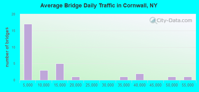
- 333,188Total average daily traffic
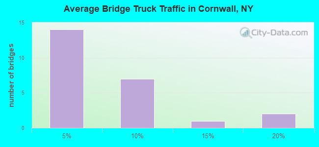
- 19,121Total average daily truck traffic
- National Bridge Inventory (NBI) Registered Bridges for Cornwall
- No street view available for this location
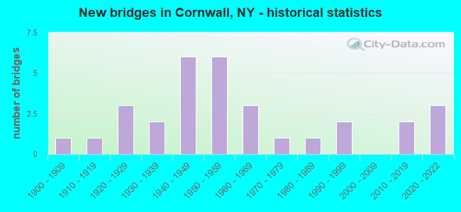
- New bridges - historical statistics
- 11900-1909
- 11910-1919
- 31920-1929
- 21930-1939
- 61940-1949
- 61950-1959
- 31960-1969
- 11970-1979
- 11980-1989
- 21990-1999
- 22010-2019
- 32020-2022
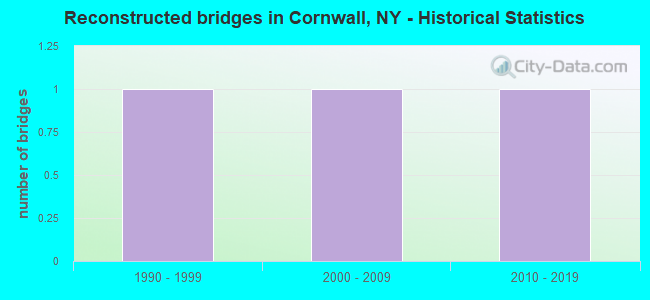
- Reconstructed bridges - Historical Statistics
- 11990-1999
- 12000-2009
- 12010-2019
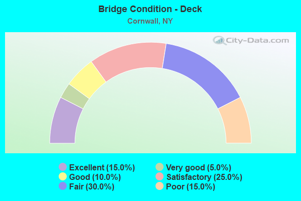
- Bridge Condition - Deck
- 15.0%Excellent
- 5.0%Very good
- 10.0%Good
- 25.0%Satisfactory
- 30.0%Fair
- 15.0%Poor
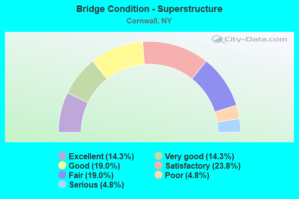
- Bridge Condition - Superstructure
- 14.3%Excellent
- 14.3%Very good
- 19.0%Good
- 23.8%Satisfactory
- 19.0%Fair
- 4.8%Poor
- 4.8%Serious
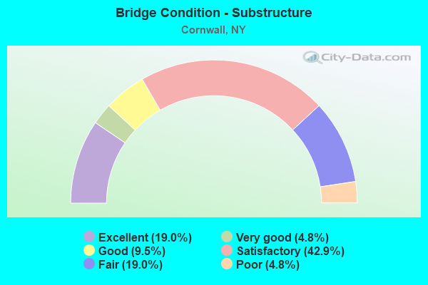
- Bridge Condition - Substructure
- 19.0%Excellent
- 4.8%Very good
- 9.5%Good
- 42.9%Satisfactory
- 19.0%Fair
- 4.8%Poor
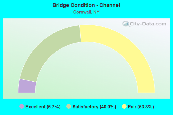
- Bridge Condition - Channel
- 6.7%Excellent
- 40.0%Satisfactory
- 53.3%Fair
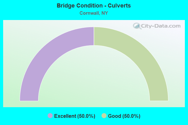
- Bridge Condition - Culverts
- 50.0%Excellent
- 50.0%Good
Find on map >> Show street view
Structure Number: 1007209, Location: 4.6 MI N JCT US9W & SH293 (Lat: 41.420411, Lng: -74.027564), Route carried "on" structure: US 9W, Year Built: 1937, Status: Open, Structure Length: 0.67m (2.20ft), Average Daily Traffic: 13,013 (year 2020), Truck Traffic: 5%, Average Future Daily Traffic: 13,074 (year 2040), Design Load: H 20, Features Intersected: BLACK FOREST CRK
Minimum Vertical Clearance: 30+ m (98+ ft), Kilometerpoint: 16.364, Lanes on structure: 4, Base Highway Network: Yes, Owner: State Highway Agency, Approaching Roadway Width: 17.7m (58.1ft), Skew: 23 degrees, Material/Design: Concrete, Design/Construction: Culvert, Number Of Spans In Main Unit: 1, Length of Maximum Span: 6.4m (21.0ft)
Condition: Channel: Satisfactory, Culverts: Good, Structural Evaluation: Better than present minimum criteria, Waterway Adequacy: Meets minimum limits, Approach Roadway Alignment: Equal to present desirable criteria, Length Of Structure Improvement: 0.67m (2.20ft), Designated Inspection Frequency: Every 24 months, Inspection Date: September 2021, Bridge Improvement Cost: $334,000, Roadway Improvement Cost: $196,000, Total Project Cost: $530,000 ( Estimate for 2021)
Find on map >> Show street view
Structure Number: 100721, Location: 6.6 MI N JCT RTS 9W+293 (Lat: 41.427636, Lng: -74.042169), Route carried "on" structure: County highway , Year Built: 2021, Status: Open, Structure Length: 3.26m (10.70ft), Average Daily Traffic: 3,675 (year 2020), Truck Traffic: 4%, Average Future Daily Traffic: 4,547 (year 2040), Design Load: HL 93, Features Intersected: 9W 9W83021111 NB, 9W 9, Facility Carried by Structure: ANGOLA ROAD
Minimum Vertical Clearance: 32.69m (107.25ft), Kilometerpoint: 13.178, Lanes on structure: 2, Lanes under structure: 4, Owner: State Highway Agency, Approaching Roadway Width: 11.0m (36.1ft), Material/Design: Steel, Design/Construction: Stringer/Multi-beam, Number Of Spans In Main Unit: 1, Length of Maximum Span: 30.8m (101.0ft), Curb-To-Curb Width: 10.9m (35.8ft), Out-to-Out Width: 12.3m (40.4ft)
Condition: Deck: Excellent, Superstructure: Excellent, Substructure: Excellent, Inventory Rating: 73.5 metric tons, Method Used To Determine Inventory Rating: Load Factor (LF), Structural Evaluation: Superior to present desirable criteria, Deck Geometry: Somewhat better than minimum adequacy, Underclear: High priority of corrective action, Approach Roadway Alignment: Equal to present desirable criteria, Designated Inspection Frequency: Every 24 months, Inspection Date: September 2021, Deck Structure Type: Concrete Cast-file-Place, Wearing Surface/Protective System: Wearing Surface: Integral Concrete, Deck Protection: Epoxy Coated Reinforcing
Find on map >> Show street view
Structure Number: 1007229, Location: 7 MI N JCT US 9W & SH 293 (Lat: 41.432839, Lng: -74.044867), Route carried "on" structure: US 9, Year Built: 2021, Status: Open, Structure Length: 3.17m (10.40ft), Average Daily Traffic: 13,338 (year 2019), Truck Traffic: 5%, Average Future Daily Traffic: 13,400 (year 2040), Design Load: HL 93, Features Intersected: COUNTY ROAD 107 - QUAKER
Minimum Vertical Clearance: 32.69m (107.25ft), Kilometerpoint: 18.552, Lanes on structure: 4, Lanes under structure: 2, Owner: State Highway Agency, Approaching Roadway Width: 20.7m (67.9ft), Skew: 32 degrees, Material/Design: Steel, Design/Construction: Stringer/Multi-beam, Number Of Spans In Main Unit: 1, Length of Maximum Span: 31.1m (102.0ft), Curb-To-Curb Width: 20.8m (68.2ft), Out-to-Out Width: 21.7m (71.2ft)
Condition: Deck: Very good, Superstructure: Excellent, Substructure: Excellent, Operating Rating: 74.4 metric tons, Method Used To Determine Operating Rating: Load Factor (LF), Inventory Rating: 44.5 metric tons, Method Used To Determine Inventory Rating: Load Factor (LF), Structural Evaluation: Superior to present desirable criteria, Deck Geometry: Superior to present desirable criteria, Underclear: Equal to present minimum criteria, Approach Roadway Alignment: Better than present minimum criteria, Designated Inspection Frequency: Every 24 months, Inspection Date: August 2021, Deck Structure Type: Concrete Cast-file-Place, Wearing Surface/Protective System: Wearing Surface: Integral Concrete
Find on map >> Show street view
Structure Number: 100723, Location: .6 MI SW JCT US9W & SH218 (Lat: 41.441481, Lng: -74.041592), Route carried "on" structure: County highway , Year Built: 1941, Year Reconstructed: 2003, Status: Open, Structure Length: 5.49m (18.01ft), Average Daily Traffic: 1,124 (year 2020), Truck Traffic: 3%, Average Future Daily Traffic: 1,390 (year 2040), Design Load: H 20, Features Intersected: RTE 9W, Facility Carried by Structure: WILLOW AVENUE
Minimum Vertical Clearance: 30+ m (98+ ft), Kilometerpoint: 2.076, Lanes on structure: 2, Lanes under structure: 4, Owner: State Highway Agency, Approaching Roadway Width: 7.3m (24.0ft), Skew: 2 degrees, Material/Design: Steel, Design/Construction: Stringer/Multi-beam, Number Of Spans In Main Unit: 1, Length of Maximum Span: 34.7m (113.8ft), Curb or Sidewalk Widths: Left: 1.5m (4.9ft), Right: 1.5m (4.9ft), Curb-To-Curb Width: 7.9m (25.9ft), Out-to-Out Width: 11.9m (39.0ft)
Condition: Deck: Excellent, Superstructure: Excellent, Substructure: Excellent, Inventory Rating: 72.6 metric tons, Method Used To Determine Inventory Rating: Load Factor (LF), Structural Evaluation: Superior to present desirable criteria, Deck Geometry: Meets minimum limits, Underclear: High priority of corrective action, Approach Roadway Alignment: Meets minimum limits, Length Of Structure Improvement: 4.20m (13.78ft), Designated Inspection Frequency: Every 24 months, Inspection Date: April 2021, Bridge Improvement Cost: $2,210,000, Roadway Improvement Cost: $1,294,000, Total Project Cost: $3,505,000 ( Estimate for 2021), Deck Structure Type: Concrete Cast-file-Place, Wearing Surface/Protective System: Wearing Surface: Bituminous
Find on map >> Show street view
Structure Number: 1007249, Location: 8.3 MI N JCT RTS 9W + 293 (Lat: 41.449075, Lng: -74.032336), Route carried "on" structure: US 9W, Year Built: 1941, Status: Open, Structure Length: 1.46m (4.79ft), Average Daily Traffic: 11,368 (year 2020), Truck Traffic: 5%, Average Future Daily Traffic: 11,421 (year 2040), Design Load: H 20, Features Intersected: RTE 218
Minimum Vertical Clearance: 30+ m (98+ ft), Kilometerpoint: 20.708, Lanes on structure: 2, Lanes under structure: 2, Base Highway Network: Yes, Owner: State Highway Agency, Approaching Roadway Width: 17.7m (58.1ft), Skew: 23 degrees, Material/Design: Concrete, Design/Construction: Frame, Number Of Spans In Main Unit: 1, Length of Maximum Span: 13.1m (43.0ft), Curb-To-Curb Width: 7.3m (24.0ft), Out-to-Out Width: 18.9m (62.0ft)
Condition: Deck: Fair, Superstructure: Fair, Substructure: Satisfactory, Operating Rating: 66.2 metric tons, Method Used To Determine Operating Rating: Allowable Stress (AS), Inventory Rating: 26.3 metric tons, Method Used To Determine Inventory Rating: Allowable Stress (AS), Structural Evaluation: Somewhat better than minimum adequacy, Deck Geometry: High priority of replacement, Underclear: High priority of corrective action, Approach Roadway Alignment: Meets minimum limits, Length Of Structure Improvement: 1.46m (4.79ft), Designated Inspection Frequency: Every 24 months, Inspection Date: March 2021, Bridge Improvement Cost: $1,866,000, Roadway Improvement Cost: $1,092,000, Total Project Cost: $2,958,000 ( Estimate for 2021), Wearing Surface/Protective System: Wearing Surface: Bituminous
Find on map >> Show street view
Structure Number: 102224, Location: 1.6 MI S JCT RTS 32+94 (Lat: 41.433094, Lng: -74.054192), Route carried "on" structure: State highway 32, Year Built: 1932, Year Reconstructed: 2013, Status: Open, Structure Length: 5.49m (18.01ft), Average Daily Traffic: 15,896 (year 2017), Truck Traffic: 5%, Average Future Daily Traffic: 19,310 (year 2040), Design Load: HS 20, Features Intersected: MOODNA CREEK
Minimum Vertical Clearance: 4.62m (15.16ft), Kilometerpoint: 15.961, Lanes on structure: 2, Base Highway Network: Yes, Owner: State Highway Agency, Approaching Roadway Width: 11.3m (37.1ft), Skew: 20 degrees, Material/Design: Steel, Design/Construction: Truss - Thru, Number Of Spans In Main Unit: 1, Length of Maximum Span: 53.3m (174.9ft), Curb-To-Curb Width: 11.4m (37.4ft), Out-to-Out Width: 12.6m (41.3ft)
Condition: Deck: Good, Superstructure: Satisfactory, Substructure: Satisfactory, Channel: Fair, Operating Rating: 47.6 metric tons, Method Used To Determine Operating Rating: Load and Resistance Factor Rating (LRFR) rating reported by rating factor(RF) method using HL-93 loadings, Inventory Rating: 36.6 metric tons, Method Used To Determine Inventory Rating: Load and Resistance Factor Rating (LRFR) rating reported by rating factor(RF) method using HL-93 loadings, Structural Evaluation: Equal to present minimum criteria, Deck Geometry: Meets minimum limits, Waterway Adequacy: Superior to present desirable criteria, Approach Roadway Alignment: Equal to present desirable criteria, Length Of Structure Improvement: 5.48m (17.98ft), Designated Inspection Frequency: Every 24 months, Critical Feature Inspection Frequency: Every 24 months, Inspection Date: September 2021, Critical Feature Inspection Date: September 2021, Bridge Improvement Cost: $6,414,000, Roadway Improvement Cost: $3,756,000, Total Project Cost: $10,169,000 ( Estimate for 2021), Deck Structure Type: Concrete Cast-file-Place, Wearing Surface/Protective System: Wearing Surface: Integral Concrete, Deck Protection: Epoxy Coated Reinforcing
Find on map >> Show street view
Structure Number: 222312, Location: 4.2 MI SW OF CORNWALL (Lat: 41.404869, Lng: -74.077969), Route carried "on" structure: ServiceOther road , Year Built: 2016, Status: Open, Structure Length: 1.55m (5.09ft), Average Daily Traffic: 967 (year 2018), Truck Traffic: 2%, Average Future Daily Traffic: 1,354 (year 2038), Design Load: HL 93, Features Intersected: WOODBURY CREEK, Facility Carried by Structure: TAYLOR ROAD
Minimum Vertical Clearance: 30+ m (98+ ft), Kilometerpoint: 2.639, Lanes on structure: 2, Owner: Town or Township Highway Agency, Approaching Roadway Width: 8.2m (26.9ft), Material/Design: Concrete, Design/Construction: Frame, Number Of Spans In Main Unit: 1, Length of Maximum Span: 14.6m (47.9ft), Curb-To-Curb Width: 8.5m (27.9ft), Out-to-Out Width: 9.6m (31.5ft)
Condition: Superstructure: Very good, Substructure: Excellent, Channel: Satisfactory, Operating Rating: 68.9 metric tons, Method Used To Determine Operating Rating: Load Factor (LF), Inventory Rating: 40.8 metric tons, Method Used To Determine Inventory Rating: Load Factor (LF), Structural Evaluation: Equal to present desirable criteria, Deck Geometry: Somewhat better than minimum adequacy, Waterway Adequacy: Superior to present desirable criteria, Approach Roadway Alignment: High priority of corrective action, Length Of Structure Improvement: 1.55m (5.09ft), Designated Inspection Frequency: Every 24 months, Inspection Date: December 2020, Bridge Improvement Cost: $505,000, Roadway Improvement Cost: $296,000, Total Project Cost: $800,000 ( Estimate for 2021), Wearing Surface/Protective System: Wearing Surface: Bituminous, Membrane: Other
Find on map >> Show street view
Structure Number: 222313, Location: 1.5 MI SW OF CORNWALL (Lat: 41.424603, Lng: -74.029389), Route carried "on" structure: Other road , Year Built: 1920, Status: Open, Structure Length: 0.82m (2.69ft), Average Daily Traffic: 204 (year 2016), Truck Traffic: 4%, Average Future Daily Traffic: 286 (year 2036), Features Intersected: IDLEWILD CREEK, Facility Carried by Structure: BOULEVARD ROAD
Minimum Vertical Clearance: 30+ m (98+ ft), Kilometerpoint: 0.129, Lanes on structure: 2, Owner: Town or Township Highway Agency, Approaching Roadway Width: 5.8m (19.0ft), Skew: 3 degrees, Material/Design: Steel, Design/Construction: Stringer/Multi-beam, Number Of Spans In Main Unit: 1, Length of Maximum Span: 7.6m (24.9ft), Curb-To-Curb Width: 5.5m (18.0ft), Out-to-Out Width: 6.3m (20.7ft)
Condition: Deck: Satisfactory, Superstructure: Fair, Substructure: Satisfactory, Channel: Fair, Operating Rating: 48.1 metric tons, Method Used To Determine Operating Rating: Load Factor (LF), Inventory Rating: 29.0 metric tons, Method Used To Determine Inventory Rating: Load Factor (LF), Structural Evaluation: Somewhat better than minimum adequacy, Deck Geometry: High priority of corrective action, Waterway Adequacy: Meets minimum limits, Approach Roadway Alignment: Somewhat better than minimum adequacy, Length Of Structure Improvement: 0.82m (2.69ft), Designated Inspection Frequency: Every 24 months, Inspection Date: July 2020, Bridge Improvement Cost: $299,000, Roadway Improvement Cost: $175,000, Total Project Cost: $474,000 ( Estimate for 2021), Deck Structure Type: Concrete Cast-file-Place, Wearing Surface/Protective System: Wearing Surface: Bituminous
Find on map >> Show street view
Structure Number: 321012, Location: 4.9 MI N OF LUDLOWVILLE (Lat: 42.622944, Lng: -76.537700), Route carried "on" structure: Other road , Year Built: 1977, Status: Open, Structure Length: 2.04m (6.69ft), Average Daily Traffic: 213 (year 2016), Truck Traffic: 8%, Average Future Daily Traffic: 298 (year 2036), Design Load: HS 20, Features Intersected: SALMON CREEK, Facility Carried by Structure: SALMON CREEK ROAD
Minimum Vertical Clearance: 30+ m (98+ ft), Kilometerpoint: 8.109, Lanes on structure: 2, Owner: County Highway Agency, Approaching Roadway Width: 6.1m (20.0ft), Material/Design: Steel, Design/Construction: Stringer/Multi-beam, Number Of Spans In Main Unit: 1, Length of Maximum Span: 20.1m (65.9ft), Curb-To-Curb Width: 8.8m (28.9ft), Out-to-Out Width: 9.8m (32.2ft)
Condition: Deck: Fair, Superstructure: Satisfactory, Substructure: Fair, Channel: Fair, Operating Rating: 64.4 metric tons, Method Used To Determine Operating Rating: Load Factor (LF), Inventory Rating: 38.1 metric tons, Method Used To Determine Inventory Rating: Load Factor (LF), Structural Evaluation: Somewhat better than minimum adequacy, Deck Geometry: Equal to present minimum criteria, Waterway Adequacy: Meets minimum limits, Approach Roadway Alignment: Somewhat better than minimum adequacy, Length Of Structure Improvement: 2.04m (6.69ft), Designated Inspection Frequency: Every 24 months, Inspection Date: September 2021, Bridge Improvement Cost: $748,000, Roadway Improvement Cost: $438,000, Total Project Cost: $1,185,000 ( Estimate for 2021), Deck Structure Type: Concrete Cast-file-Place, Wearing Surface/Protective System: Wearing Surface: Integral Concrete, Deck Protection: Other Coated Reinforcing
Find on map >> Show street view
Structure Number: 321032, Location: 1 MI SW FREEVLE VIRGIL CK (Lat: 42.504850, Lng: -76.349675), Route carried "on" structure: Other road , Year Built: 1985, Status: Open, Structure Length: 1.34m (4.40ft), Average Daily Traffic: 524 (year 2016), Truck Traffic: 11%, Average Future Daily Traffic: 734 (year 2036), Design Load: HS 20, Features Intersected: VIRGIL CREEK, Facility Carried by Structure: JOHNSON ROAD
Minimum Vertical Clearance: 32.69m (107.25ft), Kilometerpoint: 0.595, Lanes on structure: 2, Owner: County Highway Agency, Approaching Roadway Width: 7.9m (25.9ft), Material/Design: Steel, Design/Construction: Stringer/Multi-beam, Number Of Spans In Main Unit: 1, Length of Maximum Span: 12.4m (40.7ft), Curb-To-Curb Width: 7.9m (25.9ft), Out-to-Out Width: 8.5m (27.9ft)
Condition: Deck: Excellent, Superstructure: Very good, Substructure: Very good, Channel: Fair, Operating Rating: 29.9 metric tons, Method Used To Determine Operating Rating: Allowable Stress (AS), Inventory Rating: 19.1 metric tons, Method Used To Determine Inventory Rating: Allowable Stress (AS), Structural Evaluation: Somewhat better than minimum adequacy, Deck Geometry: Somewhat better than minimum adequacy, Waterway Adequacy: Meets minimum limits, Approach Roadway Alignment: Equal to present minimum criteria, Length Of Structure Improvement: 1.34m (4.40ft), Designated Inspection Frequency: Every 24 months, Inspection Date: May 2021, Bridge Improvement Cost: $358,000, Roadway Improvement Cost: $209,000, Total Project Cost: $567,000 ( Estimate for 2021), Deck Structure Type: Wood or Timber, Wearing Surface/Protective System: Wearing Surface: Bituminous
Find on map >> Show street view
Structure Number: 334428, Location: 1.1 MI W OF CORNWALL (Lat: 41.434142, Lng: -74.035597), Route carried "on" structure: Other road , Year Built: 1940, Status: Open, Structure Length: 1.16m (3.81ft), Average Daily Traffic: 1,531 (year 2020), Truck Traffic: 2%, Average Future Daily Traffic: 2,143 (year 2040), Design Load: H 15, Features Intersected: IDLEWILD CREEK, Facility Carried by Structure: HASBROUCK AVENUE
Minimum Vertical Clearance: 30+ m (98+ ft), Kilometerpoint: 0.016, Lanes on structure: 2, Owner: County Highway Agency, Approaching Roadway Width: 7.3m (24.0ft), Skew: 2 degrees, Material/Design: Steel, Design/Construction: Stringer/Multi-beam, Number Of Spans In Main Unit: 1, Length of Maximum Span: 11.2m (36.7ft), Curb or Sidewalk Widths: Left: 0.0m, Right: 1.2m (3.9ft), Curb-To-Curb Width: 7.3m (24.0ft), Out-to-Out Width: 9.1m (29.9ft)
Condition: Deck: Poor, Superstructure: Satisfactory, Substructure: Satisfactory, Channel: Satisfactory, Operating Rating: 38.1 metric tons, Method Used To Determine Operating Rating: Load Factor (LF), Inventory Rating: 22.7 metric tons, Method Used To Determine Inventory Rating: Load Factor (LF), Structural Evaluation: Equal to present minimum criteria, Deck Geometry: Meets minimum limits, Waterway Adequacy: Somewhat better than minimum adequacy, Approach Roadway Alignment: High priority of corrective action, Length Of Structure Improvement: 1.15m (3.77ft), Designated Inspection Frequency: Every 24 months, Inspection Date: September 2020, Bridge Improvement Cost: $689,000, Roadway Improvement Cost: $404,000, Total Project Cost: $1,093,000 ( Estimate for 2021), Deck Structure Type: Concrete Cast-file-Place, Wearing Surface/Protective System: Wearing Surface: Bituminous
Find on map >> Show street view
Structure Number: 334429, Location: 4.4 MI SW OF CORNWALL (Lat: 41.402081, Lng: -74.078997), Route carried "on" structure: Other road , Year Built: 1910, Status: Posted for load, Structure Length: 1.86m (6.10ft), Average Daily Traffic: 25 (year 2016), Average Future Daily Traffic: 35 (year 2036), Features Intersected: WOODBURY CREEK, Facility Carried by Structure: CREAMERY HILL ROAD
Minimum Vertical Clearance: 30+ m (98+ ft), Kilometerpoint: 0.274, Lanes on structure: 2, Owner: Town or Township Highway Agency, Approaching Roadway Width: 5.2m (17.1ft), Material/Design: Steel, Design/Construction: Truss - Thru, Number Of Spans In Main Unit: 1, Length of Maximum Span: 18.3m (60.0ft), Curb-To-Curb Width: 6.7m (22.0ft), Out-to-Out Width: 7.6m (24.9ft)
Condition: Deck: Poor, Superstructure: Serious, Substructure: Poor, Channel: Fair, Operating Rating: 6.5 metric tons, Method Used To Determine Operating Rating: Load and Resistance Factor Rating (LRFR) rating reported by rating factor(RF) method using HL-93 loadings, Inventory Rating: 4.9 metric tons, Method Used To Determine Inventory Rating: Load and Resistance Factor Rating (LRFR) rating reported by rating factor(RF) method using HL-93 loadings, Structural Evaluation: High priority of corrective action, Deck Geometry: Somewhat better than minimum adequacy, Waterway Adequacy: Meets minimum limits, Approach Roadway Alignment: Somewhat better than minimum adequacy, Bridge Posting: Required (Relationship of Operating Rating to Maximum Legal Load: > 39.9% below), Length Of Structure Improvement: 1.85m (6.07ft), Designated Inspection Frequency: Every 12 months, Critical Feature Inspection Frequency: Every 12 months, Inspection Date: July 2021, Critical Feature Inspection Date: July 2021, Bridge Improvement Cost: $1,916,000, Roadway Improvement Cost: $1,122,000, Total Project Cost: $3,038,000 ( Estimate for 2021), Deck Structure Type: Concrete Cast-file-Place, Wearing Surface/Protective System: Wearing Surface: Bituminous
Find on map >> Show street view
Structure Number: 33443, Location: 1.0 MI W OF CORNWALL (Lat: 41.436917, Lng: -74.032983), Route carried "on" structure: County highway , Year Built: 2015, Status: Open, Structure Length: 0.82m (2.69ft), Average Daily Traffic: 1,124 (year 2020), Truck Traffic: 3%, Average Future Daily Traffic: 1,390 (year 2040), Design Load: HS 20, Features Intersected: IDLEWILD CREEK, Facility Carried by Structure: WILLOW AVENUE
Minimum Vertical Clearance: 30+ m (98+ ft), Kilometerpoint: 2.977, Lanes on structure: 2, Owner: County Highway Agency, Approaching Roadway Width: 9.1m (29.9ft), Skew: 2 degrees, Material/Design: Aluminum, Iron, Design/Construction: Culvert, Number Of Spans In Main Unit: 1, Length of Maximum Span: 7.6m (24.9ft), Curb or Sidewalk Widths: Left: 0.0m, Right: 1.5m (4.9ft)
Condition: Channel: Excellent, Culverts: Excellent, Operating Rating: 78.0 metric tons, Method Used To Determine Operating Rating: Field evaluation and documented engineering judgment, Inventory Rating: 32.7 metric tons, Method Used To Determine Inventory Rating: Field evaluation and documented engineering judgment, Structural Evaluation: Superior to present desirable criteria, Waterway Adequacy: Somewhat better than minimum adequacy, Approach Roadway Alignment: Better than present minimum criteria, Length Of Structure Improvement: 0.82m (2.69ft), Designated Inspection Frequency: Every 24 months, Inspection Date: July 2020, Bridge Improvement Cost: $212,000, Roadway Improvement Cost: $124,000, Total Project Cost: $336,000 ( Estimate for 2021), Wearing Surface/Protective System: Wearing Surface: Bituminous
Find on map >> Show street view
Structure Number: 334431, Location: 3.3 MI E WASHINGTONVILLE (Lat: 41.425972, Lng: -74.087494), Route carried "on" structure: Other road , Year Built: 1966, Status: Open, Structure Length: 2.96m (9.71ft), Average Daily Traffic: 1,483 (year 2015), Truck Traffic: 2%, Average Future Daily Traffic: 2,076 (year 2035), Design Load: HS 20, Features Intersected: MOODNA CREEK, Facility Carried by Structure: OTTERKILL ROAD
Minimum Vertical Clearance: 30+ m (98+ ft), Kilometerpoint: 1.432, Lanes on structure: 2, Owner: County Highway Agency, Approaching Roadway Width: 7.6m (24.9ft), Material/Design: Steel, Design/Construction: Stringer/Multi-beam, Number Of Spans In Main Unit: 1, Length of Maximum Span: 28.0m (91.9ft), Curb-To-Curb Width: 8.5m (27.9ft), Out-to-Out Width: 9.4m (30.8ft)
Condition: Deck: Satisfactory, Superstructure: Good, Substructure: Satisfactory, Channel: Satisfactory, Operating Rating: 93.4 metric tons, Method Used To Determine Operating Rating: Load Factor (LF), Inventory Rating: 55.3 metric tons, Method Used To Determine Inventory Rating: Load Factor (LF), Structural Evaluation: Equal to present minimum criteria, Deck Geometry: Somewhat better than minimum adequacy, Waterway Adequacy: Somewhat better than minimum adequacy, Approach Roadway Alignment: Equal to present desirable criteria, Length Of Structure Improvement: 2.95m (9.68ft), Designated Inspection Frequency: Every 24 months, Inspection Date: December 2020, Bridge Improvement Cost: $1,948,000, Roadway Improvement Cost: $1,140,000, Total Project Cost: $3,088,000 ( Estimate for 2021), Deck Structure Type: Concrete Cast-file-Place, Wearing Surface/Protective System: Wearing Surface: Bituminous
Find on map >> Show street view
Structure Number: 334432, Location: 0.8 MI N OF CORNWALL (Lat: 41.452622, Lng: -74.021033), Route carried "on" structure: Other road , Year Built: 1962, Status: Open, Structure Length: 1.83m (6.00ft), Average Daily Traffic: 1,452 (year 2018), Truck Traffic: 4%, Average Future Daily Traffic: 2,033 (year 2038), Design Load: H 20, Features Intersected: IDLEWILD CREEK, Facility Carried by Structure: SHORE ROAD
Minimum Vertical Clearance: 30+ m (98+ ft), Kilometerpoint: 0.000, Lanes on structure: 2, Owner: County Highway Agency, Approaching Roadway Width: 7.3m (24.0ft), Material/Design: Steel, Design/Construction: Stringer/Multi-beam, Number Of Spans In Main Unit: 1, Length of Maximum Span: 17.0m (55.8ft), Curb-To-Curb Width: 8.5m (27.9ft), Out-to-Out Width: 9.4m (30.8ft)
Condition: Deck: Satisfactory, Superstructure: Good, Substructure: Satisfactory, Channel: Satisfactory, Operating Rating: 46.3 metric tons, Method Used To Determine Operating Rating: Load Factor (LF), Inventory Rating: 27.2 metric tons, Method Used To Determine Inventory Rating: Load Factor (LF), Structural Evaluation: Equal to present minimum criteria, Deck Geometry: Somewhat better than minimum adequacy, Waterway Adequacy: Equal to present desirable criteria, Approach Roadway Alignment: Equal to present desirable criteria, Length Of Structure Improvement: 1.82m (5.97ft), Designated Inspection Frequency: Every 24 months, Inspection Date: September 2020, Bridge Improvement Cost: $989,000, Roadway Improvement Cost: $579,000, Total Project Cost: $1,568,000 ( Estimate for 2021), Deck Structure Type: Concrete Cast-file-Place, Wearing Surface/Protective System: Wearing Surface: Bituminous
Find on map >> Show street view
Structure Number: 334433, Location: 2.7 MI SW OF CORNWALL (Lat: 41.409317, Lng: -74.073336), Route carried "on" structure: County highway , Year Built: 1969, Status: Open, Structure Length: 2.96m (9.71ft), Average Daily Traffic: 501 (year 2017), Truck Traffic: 7%, Average Future Daily Traffic: 619 (year 2040), Design Load: HS 20, Features Intersected: MOODNA CREEK, Facility Carried by Structure: PLEASANT HILL RD
Minimum Vertical Clearance: 30+ m (98+ ft), Kilometerpoint: 0.805, Lanes on structure: 2, Owner: County Highway Agency, Approaching Roadway Width: 6.7m (22.0ft), Material/Design: Steel, Design/Construction: Stringer/Multi-beam, Number Of Spans In Main Unit: 1, Length of Maximum Span: 28.0m (91.9ft), Curb-To-Curb Width: 8.5m (27.9ft), Out-to-Out Width: 9.4m (30.8ft)
Condition: Deck: Fair, Superstructure: Good, Substructure: Satisfactory, Channel: Fair, Operating Rating: 63.5 metric tons, Method Used To Determine Operating Rating: Load and Resistance Factor Rating (LRFR) rating reported by rating factor(RF) method using HL-93 loadings, Inventory Rating: 48.9 metric tons, Method Used To Determine Inventory Rating: Load and Resistance Factor Rating (LRFR) rating reported by rating factor(RF) method using HL-93 loadings, Structural Evaluation: Equal to present minimum criteria, Deck Geometry: Somewhat better than minimum adequacy, Waterway Adequacy: Somewhat better than minimum adequacy, Approach Roadway Alignment: Equal to present minimum criteria, Length Of Structure Improvement: 2.95m (9.68ft), Designated Inspection Frequency: Every 24 months, Inspection Date: May 2020, Bridge Improvement Cost: $1,631,000, Roadway Improvement Cost: $955,000, Total Project Cost: $2,586,000 ( Estimate for 2021), Deck Structure Type: Concrete Cast-file-Place, Wearing Surface/Protective System: Wearing Surface: Bituminous
Find on map >> Show street view
Structure Number: 334543, Location: 0.9 MI W OF CORNWALL (Lat: 41.443000, Lng: -74.029036), Route carried "on" structure: County highway , Year Built: 1929, Status: Open, Structure Length: 1.37m (4.49ft), Average Daily Traffic: 1,350 (year 2017), Truck Traffic: 2%, Average Future Daily Traffic: 1,670 (year 2040), Features Intersected: IDLEWILD CREEK, Facility Carried by Structure: MAIN STREET
Minimum Vertical Clearance: 30+ m (98+ ft), Kilometerpoint: 15.350, Lanes on structure: 2, Owner: County Highway Agency, Approaching Roadway Width: 7.3m (24.0ft), Skew: 3 degrees, Material/Design: Concrete, Design/Construction: Tee Beam, Number Of Spans In Main Unit: 1, Length of Maximum Span: 13.1m (43.0ft), Curb or Sidewalk Widths: Left: 1.2m (3.9ft), Right: 0.0m, Curb-To-Curb Width: 8.0m (26.2ft), Out-to-Out Width: 10.1m (33.1ft)
Condition: Deck: Fair, Superstructure: Poor, Substructure: Fair, Channel: Fair, Operating Rating: 39.7 metric tons, Method Used To Determine Operating Rating: Field evaluation and documented engineering judgment, Inventory Rating: 11.0 metric tons, Method Used To Determine Inventory Rating: Field evaluation and documented engineering judgment, Structural Evaluation: High priority of corrective action, Deck Geometry: Meets minimum limits, Waterway Adequacy: Meets minimum limits, Approach Roadway Alignment: Better than present minimum criteria, Length Of Structure Improvement: 1.37m (4.49ft), Designated Inspection Frequency: Every 24 months, Inspection Date: September 2021, Bridge Improvement Cost: $575,000, Roadway Improvement Cost: $337,000, Total Project Cost: $912,000 ( Estimate for 2021), Deck Structure Type: Concrete Cast-file-Place, Wearing Surface/Protective System: Wearing Surface: Bituminous
Find on map >> Show street view
Structure Number: 334544, Location: 1.0 MI W OF CORNWALL (Lat: 41.434814, Lng: -74.035500), Route carried "on" structure: County highway , Year Built: 1929, Status: Open, Structure Length: 1.37m (4.49ft), Average Daily Traffic: 5,623 (year 2020), Truck Traffic: 4%, Average Future Daily Traffic: 6,957 (year 2040), Features Intersected: IDLEWILD CREEK, Facility Carried by Structure: MAIN STREET CR9
Minimum Vertical Clearance: 30+ m (98+ ft), Kilometerpoint: 14.159, Lanes on structure: 2, Owner: County Highway Agency, Approaching Roadway Width: 13.1m (43.0ft), Material/Design: Concrete continuous, Design/Construction: Slab, Number Of Spans In Main Unit: 2, Length of Maximum Span: 6.4m (21.0ft), Curb or Sidewalk Widths: Left: 1.4m (4.6ft), Right: 1.4m (4.6ft), Curb-To-Curb Width: 13.2m (43.3ft), Out-to-Out Width: 16.6m (54.5ft)
Condition: Deck: Poor, Superstructure: Fair, Substructure: Satisfactory, Channel: Fair, Operating Rating: 51.6 metric tons, Method Used To Determine Operating Rating: Field evaluation and documented engineering judgment, Inventory Rating: 22.0 metric tons, Method Used To Determine Inventory Rating: Field evaluation and documented engineering judgment, Structural Evaluation: Somewhat better than minimum adequacy, Deck Geometry: Somewhat better than minimum adequacy, Waterway Adequacy: High priority of corrective action, Approach Roadway Alignment: High priority of corrective action, Length Of Structure Improvement: 1.37m (4.49ft), Designated Inspection Frequency: Every 24 months, Inspection Date: September 2020, Bridge Improvement Cost: $753,000, Roadway Improvement Cost: $441,000, Total Project Cost: $1,194,000 ( Estimate for 2021), Wearing Surface/Protective System: Wearing Surface: Bituminous
Find on map >> Show street view
Structure Number: 55143, Location: 1.8 MI S JCT CR20 & I87 (Lat: 41.406353, Lng: -74.080119), Route carried "on" structure: Other road , Year Built: 1953, Status: Open, Structure Length: 6.13m (20.11ft), Average Daily Traffic: 967 (year 2018), Truck Traffic: 2%, Average Future Daily Traffic: 1,354 (year 2038), Design Load: HS 20, Features Intersected: 87IX (SB), RTE I87, Facility Carried by Structure: TAYLOR RD
Minimum Vertical Clearance: 30+ m (98+ ft), Kilometerpoint: 0.241, Lanes on structure: 2, Lanes under structure: 4, Owner: State Toll Authority, Approaching Roadway Width: 6.7m (22.0ft), Material/Design: Steel, Design/Construction: Stringer/Multi-beam, Number Of Spans In Main Unit: 4, Length of Maximum Span: 17.4m (57.1ft), Curb or Sidewalk Widths: Left: 0.8m (2.6ft), Right: 0.8m (2.6ft), Curb-To-Curb Width: 7.9m (25.9ft), Out-to-Out Width: 10.1m (33.1ft)
Condition: Deck: Satisfactory, Superstructure: Fair, Substructure: Satisfactory, Operating Rating: 68.4 metric tons, Method Used To Determine Operating Rating: Load and Resistance Factor Rating (LRFR) rating reported by rating factor(RF) method using HL-93 loadings, Inventory Rating: 52.5 metric tons, Method Used To Determine Inventory Rating: Load and Resistance Factor Rating (LRFR) rating reported by rating factor(RF) method using HL-93 loadings, Structural Evaluation: Somewhat better than minimum adequacy, Deck Geometry: Somewhat better than minimum adequacy, Underclear: High priority of corrective action, Approach Roadway Alignment: Equal to present minimum criteria, Length Of Structure Improvement: 6.12m (20.08ft), Designated Inspection Frequency: Every 24 months, Inspection Date: May 2020, Bridge Improvement Cost: $2,368,000, Roadway Improvement Cost: $1,387,000, Total Project Cost: $3,754,000 ( Estimate for 2021), Deck Structure Type: Concrete Cast-file-Place, Wearing Surface/Protective System: Wearing Surface: Bituminous
Find on map >> Show street view
Structure Number: 5514319, Location: 3.0 MI S JCT RTS 94(Lat: 41.409339, Lng: -74.077108), Route carried "on" structure: Interstate 87, Year Built: 1953, Status: Open, Structure Length: 6.10m (20.01ft), Average Daily Traffic: 39,792 (year 2018), Truck Traffic: 19%, Average Future Daily Traffic: 67,383 (year 2040), Design Load: HS 20+Mod, Features Intersected: MOODNA CREEK
Minimum Vertical Clearance: 30+ m (98+ ft), Kilometerpoint: 28.206, Lanes on structure: 4, Base Highway Network: Yes, Toll: On Interstate toll segment, Owner: State Toll Authority, Approaching Roadway Width: 33.5m (109.9ft), Skew: 20 degrees, Material/Design: Steel, Design/Construction: Stringer/Multi-beam, Number Of Spans In Main Unit: 3, Length of Maximum Span: 31.0m (101.7ft), Curb-To-Curb Width: 33.2m (108.9ft), Out-to-Out Width: 34.1m (111.9ft)
Condition: Deck: Fair, Superstructure: Satisfactory, Substructure: Fair, Channel: Satisfactory, Operating Rating: 69.9 metric tons, Method Used To Determine Operating Rating: Load Factor (LF), Inventory Rating: 41.7 metric tons, Method Used To Determine Inventory Rating: Load Factor (LF), Structural Evaluation: Somewhat better than minimum adequacy, Deck Geometry: Superior to present desirable criteria, Waterway Adequacy: Superior to present desirable criteria, Approach Roadway Alignment: Equal to present desirable criteria, Length Of Structure Improvement: 6.09m (19.98ft), Designated Inspection Frequency: Every 24 months, Inspection Date: March 2021, Bridge Improvement Cost: $8,143,000, Roadway Improvement Cost: $4,769,000, Total Project Cost: $12,912,000 ( Estimate for 2021), Deck Structure Type: Concrete Cast-file-Place, Wearing Surface/Protective System: Wearing Surface: Bituminous, Membrane: Preformed Fabric
Structure Number: 5514319, Location: 3.0 MI S JCT RTS 94
Minimum Vertical Clearance: 30+ m (98+ ft), Kilometerpoint: 28.206, Lanes on structure: 4, Base Highway Network: Yes, Toll: On Interstate toll segment, Owner: State Toll Authority, Approaching Roadway Width: 33.5m (109.9ft), Skew: 20 degrees, Material/Design: Steel, Design/Construction: Stringer/Multi-beam, Number Of Spans In Main Unit: 3, Length of Maximum Span: 31.0m (101.7ft), Curb-To-Curb Width: 33.2m (108.9ft), Out-to-Out Width: 34.1m (111.9ft)
Condition: Deck: Fair, Superstructure: Satisfactory, Substructure: Fair, Channel: Satisfactory, Operating Rating: 69.9 metric tons, Method Used To Determine Operating Rating: Load Factor (LF), Inventory Rating: 41.7 metric tons, Method Used To Determine Inventory Rating: Load Factor (LF), Structural Evaluation: Somewhat better than minimum adequacy, Deck Geometry: Superior to present desirable criteria, Waterway Adequacy: Superior to present desirable criteria, Approach Roadway Alignment: Equal to present desirable criteria, Length Of Structure Improvement: 6.09m (19.98ft), Designated Inspection Frequency: Every 24 months, Inspection Date: March 2021, Bridge Improvement Cost: $8,143,000, Roadway Improvement Cost: $4,769,000, Total Project Cost: $12,912,000 ( Estimate for 2021), Deck Structure Type: Concrete Cast-file-Place, Wearing Surface/Protective System: Wearing Surface: Bituminous, Membrane: Preformed Fabric
Find on map >> Show street view
Structure Number: 551432, Location: 2.9 MI S JCT RTS 94 & I87 (Lat: 41.412142, Lng: -74.073633), Route carried "on" structure: County highway , Year Built: 1953, Year Reconstructed: 2015, Status: Open, Structure Length: 7.65m (25.10ft), Average Daily Traffic: 501 (year 2017), Truck Traffic: 7%, Average Future Daily Traffic: 619 (year 2040), Design Load: HS 20, Features Intersected: 87IX, RTE I87, Facility Carried by Structure: CR-79
Minimum Vertical Clearance: 30+ m (98+ ft), Kilometerpoint: 1.142, Lanes on structure: 2, Lanes under structure: 4, Owner: State Toll Authority, Approaching Roadway Width: 8.2m (26.9ft), Skew: 3 degrees, Material/Design: Steel, Design/Construction: Stringer/Multi-beam, Number Of Spans In Main Unit: 4, Length of Maximum Span: 21.3m (69.9ft), Curb or Sidewalk Widths: Left: 0.0m, Right: 0.5m (1.6ft), Curb-To-Curb Width: 8.1m (26.6ft), Out-to-Out Width: 10.1m (33.1ft)
Condition: Deck: Good, Superstructure: Good, Substructure: Good, Operating Rating: 88.0 metric tons, Method Used To Determine Operating Rating: Load Factor (LF), Inventory Rating: 52.6 metric tons, Method Used To Determine Inventory Rating: Load Factor (LF), Structural Evaluation: Better than present minimum criteria, Deck Geometry: Somewhat better than minimum adequacy, Underclear: High priority of corrective action, Approach Roadway Alignment: Equal to present desirable criteria, Length Of Structure Improvement: 7.65m (25.10ft), Designated Inspection Frequency: Every 24 months, Inspection Date: May 2020, Bridge Improvement Cost: $3,001,000, Roadway Improvement Cost: $1,757,000, Total Project Cost: $4,759,000 ( Estimate for 2021), Deck Structure Type: Concrete Cast-file-Place, Wearing Surface/Protective System: Wearing Surface: Monolithic Concrete
Find on map >> Show street view
Structure Number: 551433, Location: 1.6 MI S. RTS 94 & I87 (Lat: 41.429725, Lng: -74.068278), Route carried "on" structure: County highway , Year Built: 1993, Status: Open, Structure Length: 8.05m (26.41ft), Average Daily Traffic: 3,991 (year 2020), Truck Traffic: 4%, Average Future Daily Traffic: 4,848 (year 2040), Design Load: HS 25 or greater, Features Intersected: 87IX - Northbound, RTE I, Facility Carried by Structure: County Road 20
Minimum Vertical Clearance: 30+ m (98+ ft), Kilometerpoint: 5.020, Lanes on structure: 2, Lanes under structure: 4, Owner: State Toll Authority, Approaching Roadway Width: 9.4m (30.8ft), Skew: 3 degrees, Material/Design: Steel continuous, Design/Construction: Stringer/Multi-beam, Number Of Spans In Main Unit: 2, Length of Maximum Span: 45.4m (149.0ft), Curb-To-Curb Width: 9.4m (30.8ft), Out-to-Out Width: 10.1m (33.1ft)
Condition: Deck: Satisfactory, Superstructure: Very good, Substructure: Good, Operating Rating: 89.8 metric tons, Method Used To Determine Operating Rating: Load Factor (LF), Inventory Rating: 41.7 metric tons, Method Used To Determine Inventory Rating: Load Factor (LF), Structural Evaluation: Better than present minimum criteria, Deck Geometry: Meets minimum limits, Underclear: Meets minimum limits, Approach Roadway Alignment: Equal to present desirable criteria, Length Of Structure Improvement: 8.04m (26.38ft), Designated Inspection Frequency: Every 24 months, Inspection Date: July 2021, Bridge Improvement Cost: $3,230,000, Roadway Improvement Cost: $1,891,000, Total Project Cost: $5,121,000 ( Estimate for 2021), Deck Structure Type: Concrete Cast-file-Place, Wearing Surface/Protective System: Wearing Surface: Bituminous, Membrane: Other, Deck Protection: Epoxy Coated Reinforcing
Find on map >> Show street view
Structure Number: 5514349, Location: 1.2 MI S JCT SH 94 & I87 (Lat: 41.434986, Lng: -74.067803), Route carried "on" structure: Interstate 87, Year Built: 1953, Status: Open, Structure Length: 1.58m (5.18ft), Average Daily Traffic: 39,792 (year 2018), Truck Traffic: 19%, Average Future Daily Traffic: 67,383 (year 2040), Design Load: HS 20+Mod, Features Intersected: ABAND. RR (NY ONT AND WE
Minimum Vertical Clearance: 30+ m (98+ ft), Kilometerpoint: 31.295, Lanes on structure: 4, Base Highway Network: Yes, Toll: On Interstate toll segment, Owner: State Toll Authority, Approaching Roadway Width: 33.2m (108.9ft), Skew: 31 degrees, Material/Design: Concrete, Design/Construction: Frame, Number Of Spans In Main Unit: 1, Length of Maximum Span: 13.1m (43.0ft), Curb-To-Curb Width: 31.5m (103.3ft), Out-to-Out Width: 34.4m (112.9ft)
Condition: Deck: Fair, Superstructure: Satisfactory, Substructure: Fair, Operating Rating: 81.9 metric tons, Method Used To Determine Operating Rating: Field evaluation and documented engineering judgment, Inventory Rating: 32.7 metric tons, Method Used To Determine Inventory Rating: Field evaluation and documented engineering judgment, Structural Evaluation: Somewhat better than minimum adequacy, Deck Geometry: Superior to present desirable criteria, Approach Roadway Alignment: Equal to present desirable criteria, Length Of Structure Improvement: 1.58m (5.18ft), Designated Inspection Frequency: Every 24 months, Inspection Date: May 2020, Bridge Improvement Cost: $5,140,000, Roadway Improvement Cost: $3,010,000, Total Project Cost: $8,150,000 ( Estimate for 2021)
Find on map >> Show street view
Structure Number: 1007229, Location: 7 MI N JCT US 9W & SH 293 (Lat: 41.432839, Lng: -74.044867), Route carried "under" structure: County highway , Year Built: 2021, Structure Length: 0. m, Average Daily Traffic: 12,767 (year 2018), Truck Traffic: 3%, Features Intersected: COUNTY ROAD 107 - QUAKER, Facility Carried by Structure: RTE 9
Minimum Vertical Clearance: 4.60m (15.09ft), Kilometerpoint: 0.000, Lanes on structure: 4, Lanes under structure: 2, Material/Design: Steel, Design/Construction: Stringer/Multi-beam, Length of Maximum Span: 31.1m (102.0ft)
Find on map >> Show street view
Structure Number: 100723, Location: .6 MI SW JCT US9W & SH218 (Lat: 41.441481, Lng: -74.041592), Route carried "under" structure: US 9W, Year Built: 1941, Structure Length: 0. m, Average Daily Traffic: 13,183 (year 1998), Features Intersected: RTE 9W, Facility Carried by Structure: WILLOW AVENUE
Minimum Vertical Clearance: 4.75m (15.58ft), Kilometerpoint: 19.742, Lanes on structure: 2, Lanes under structure: 4, Material/Design: Steel, Design/Construction: Stringer/Multi-beam, Length of Maximum Span: 34.7m (113.8ft)
Find on map >> Show street view
Structure Number: 1007249, Location: 8.3 MI N JCT RTS 9W + 293 (Lat: 41.449075, Lng: -74.032336), Route carried "under" structure: State highway 218, Year Built: 1941, Structure Length: 0. m, Average Daily Traffic: 9,450 (year 1978), Features Intersected: RTE 218, Facility Carried by Structure: RTE 9W
Minimum Vertical Clearance: 4.98m (16.34ft), Kilometerpoint: 20.804, Lanes on structure: 2, Lanes under structure: 2, Material/Design: Concrete, Design/Construction: Frame, Length of Maximum Span: 13.1m (43.0ft)
Find on map >> Show street view
Structure Number: 55143, Location: 1.8 MI S JCT CR20 & I87 (Lat: 41.406353, Lng: -74.080119), Route carried "under" structure: Interstate 87, Year Built: 1953, Structure Length: 0. m, Average Daily Traffic: 51,500 (year 2014), Features Intersected: 87IX (SB), RTE I87, Facility Carried by Structure: TAYLOR RD
Minimum Vertical Clearance: 4.70m (15.42ft), Kilometerpoint: 84.585, Lanes on structure: 2, Lanes under structure: 2, Toll: On Interstate toll segment, Material/Design: Steel, Design/Construction: Stringer/Multi-beam, Length of Maximum Span: 17.4m (57.1ft)
Find on map >> Show street view
Structure Number: 551432, Location: 2.9 MI S JCT RTS 94 & I87 (Lat: 41.412142, Lng: -74.073633), Route carried "under" structure: Interstate 87, Year Built: 1953, Structure Length: 0. m, Average Daily Traffic: 48,006 (year 2014), Features Intersected: 87IX, RTE I87, Facility Carried by Structure: CR-79
Minimum Vertical Clearance: 4.80m (15.75ft), Kilometerpoint: 85.438, Lanes on structure: 2, Lanes under structure: 2, Toll: On Interstate toll segment, Material/Design: Steel, Design/Construction: Stringer/Multi-beam, Length of Maximum Span: 21.3m (69.9ft)
Find on map >> Show street view
Structure Number: 551433, Location: 1.6 MI S. RTS 94 & I87 (Lat: 41.429725, Lng: -74.068278), Route carried "under" structure: Interstate 87, Year Built: 1993, Structure Length: 0. m, Average Daily Traffic: 31,562 (year 1990), Features Intersected: 87IX - Northbound, RTE I, Facility Carried by Structure: County Road 20
Minimum Vertical Clearance: 6.81m (22.34ft), Kilometerpoint: 87.481, Lanes on structure: 2, Lanes under structure: 2, Toll: On Interstate toll segment, Material/Design: Steel continuous, Design/Construction: Stringer/Multi-beam, Length of Maximum Span: 45.4m (149.0ft)
Find on map >> Show street view
Structure Number: 70349, Location: 2.2 MI SW JCT SH94 & I87 (Lat: 41.435772, Lng: -74.101281), Route carried "under" structure: State highway 94, Year Built: 1940, Structure Length: 0. m, Average Daily Traffic: 7,766 (year 1999), Features Intersected: RTE 94, Facility Carried by Structure: MNRR PJ LINE
Minimum Vertical Clearance: 8.71m (28.58ft), Kilometerpoint: 43.057, Lanes under structure: 2, Material/Design: Steel, Design/Construction: Girder and Floorbeam System, Length of Maximum Span: 19.8m (65.0ft)
Find on map >> Show street view
Structure Number: 771296, Location: 4.6 MI WEST OF CORNWALL (Lat: 41.426450, Lng: -74.097408), Route carried "under" structure: County highway , Year Built: 1907, Structure Length: 0. m, Average Daily Traffic: 500 (year 2015), Truck Traffic: 2%, Features Intersected: ORRS MILLS R CR20, OTTER, Facility Carried by Structure: MNRR PJ LINE
Minimum Vertical Clearance: 22.86m (75.00ft), Kilometerpoint: 0.000, Lanes under structure: 4, Material/Design: Steel, Design/Construction: Stringer/Multi-beam, Length of Maximum Span: 33.5m (109.9ft)