Bridge Statistics for Cornelia, Georgia (GA)
Condition, Traffic, Stress, Structural Evaluation, Project Costs
- National Bridge Inventory (NBI) Statistics
- 19Number of bridges
- 213ft / 64.9mTotal length
- $12,534,000Total costs
- 157,720Total average daily traffic
- 1,573Total average daily truck traffic
- National Bridge Inventory (NBI) Registered Bridges for Cornelia
- No street view available for this location
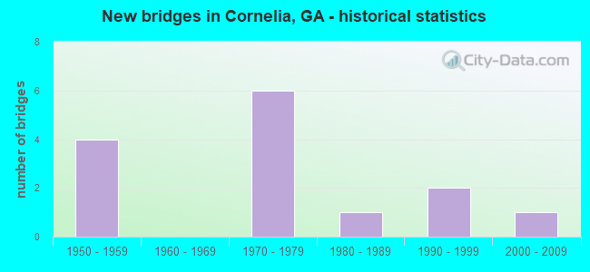
- New bridges - historical statistics
- 41950-1959
- 61970-1979
- 11980-1989
- 21990-1999
- 12000-2009


- Bridge Condition - Deck
- 87.5%Good
- 12.5%Satisfactory

- Bridge Condition - Superstructure
- 12.5%Very good
- 75.0%Good
- 12.5%Satisfactory

- Bridge Condition - Substructure
- 87.5%Good
- 12.5%Fair

- Bridge Condition - Channel
- 37.5%Very good
- 37.5%Good
- 12.5%Satisfactory
- 12.5%Fair

- Bridge Condition - Culverts
- 66.7%Good
- 33.3%Satisfactory
Find on map >> Show street view
Structure Number: 110015, Location: 9.5 MI N OF HOMER (Lat: 34.469250, Lng: -83.491689), Route carried "on" structure: State highway 105, Year Built: 1956, Status: Open, Structure Length: 1.01m (3.31ft), Average Daily Traffic: 410 (year 2012), Truck Traffic: 1%, Average Future Daily Traffic: 615 (year 2032), Design Load: H 15, Features Intersected: NANCY TOWN CREEK
Minimum Vertical Clearance: 30+ m (98+ ft), Kilometerpoint: 11.265, Lanes on structure: 2, Base Highway Network: Yes, Owner: State Highway Agency, Approaching Roadway Width: 7.3m (24.0ft), Skew: 1 degrees, Material/Design: Concrete, Design/Construction: Culvert, Number Of Spans In Main Unit: 3, Length of Maximum Span: 3.0m (9.8ft)
Condition: Channel: Very good, Culverts: Good, Operating Rating: 77.1 metric tons, Method Used To Determine Operating Rating: Load Factor (LF), Inventory Rating: 46.2 metric tons, Method Used To Determine Inventory Rating: Load Factor (LF), Structural Evaluation: Better than present minimum criteria, Waterway Adequacy: Equal to present desirable criteria, Approach Roadway Alignment: Equal to present desirable criteria, Designated Inspection Frequency: Every 24 months, Inspection Date: August 2021, Bridge Improvement Cost: $129,000, Roadway Improvement Cost: $13,000, Total Project Cost: $193,000
Find on map >> Show street view
Structure Number: 115068, Location: 9.6 MI N OF HOMER (Lat: 34.470328, Lng: -83.484358), Route carried "on" structure: State highway 105, Year Built: 2005, Status: Open, Structure Length: 5.94m (19.49ft), Average Daily Traffic: 410 (year 2012), Truck Traffic: 1%, Average Future Daily Traffic: 615 (year 2032), Design Load: HS 20+Mod, Features Intersected: MIDDLE FORK BROAD
Minimum Vertical Clearance: 30+ m (98+ ft), Kilometerpoint: 11.265, Lanes on structure: 2, Base Highway Network: Yes, Owner: State Highway Agency, Approaching Roadway Width: 8.5m (27.9ft), Skew: 1 degrees, Material/Design: Prestressed concrete, Design/Construction: Stringer/Multi-beam, Number Of Spans In Main Unit: 3, Length of Maximum Span: 21.3m (69.9ft), Curb-To-Curb Width: 12.2m (40.0ft), Out-to-Out Width: 13.1m (43.0ft)
Condition: Deck: Good, Superstructure: Very good, Substructure: Good, Channel: Good, Operating Rating: 64.4 metric tons, Method Used To Determine Operating Rating: Load Factor (LF), Inventory Rating: 32.6 metric tons, Method Used To Determine Inventory Rating: Load Factor (LF), Structural Evaluation: Better than present minimum criteria, Deck Geometry: Equal to present desirable criteria, Waterway Adequacy: Equal to present desirable criteria, Approach Roadway Alignment: Equal to present minimum criteria, Designated Inspection Frequency: Every 24 months, Inspection Date: August 2021, Deck Structure Type: Concrete Cast-file-Place
Find on map >> Show street view
Structure Number: 1370001, Location: IN WEST CORNELIA (Lat: 34.514897, Lng: -83.554158), Route carried "on" structure: Ramp State highway 15, Year Built: 1979, Status: Open, Structure Length: 8.81m (28.90ft), Average Daily Traffic: 8,900 (year 2012), Truck Traffic: 1%, Average Future Daily Traffic: 13,350 (year 2032), Design Load: HS 20+Mod, Features Intersected: SR 365 (US 23)
Minimum Vertical Clearance: 30+ m (98+ ft), Kilometerpoint: 0.000, Lanes on structure: 2, Lanes under structure: 4, Base Highway Network: Yes, Owner: State Highway Agency, Approaching Roadway Width: 11.0m (36.1ft), Skew: 1 degrees, Material/Design: Prestressed concrete continuous, Design/Construction: Box Beam or Girders - Single/Spread, Number Of Spans In Main Unit: 2, Length of Maximum Span: 44.8m (147.0ft), Curb-To-Curb Width: 13.0m (42.7ft), Out-to-Out Width: 13.9m (45.6ft)
Condition: Deck: Good, Superstructure: Good, Substructure: Good, Operating Rating: 62.5 metric tons, Method Used To Determine Operating Rating: Allowable Stress (AS), Inventory Rating: 32.6 metric tons, Method Used To Determine Inventory Rating: Allowable Stress (AS), Structural Evaluation: Better than present minimum criteria, Deck Geometry: Superior to present desirable criteria, Underclear: Superior to present desirable criteria, Approach Roadway Alignment: Equal to present desirable criteria, Designated Inspection Frequency: Every 24 months, Inspection Date: April 2020, Bridge Improvement Cost: $1,129,000, Roadway Improvement Cost: $113,000, Total Project Cost: $1,694,000, Deck Structure Type: Concrete Cast-file-Place, Wearing Surface/Protective System: Wearing Surface: Epoxy Overlay
Find on map >> Show street view
Structure Number: 1370004, Location: IN WEST CORNELIA (Lat: 34.515789, Lng: -83.544989), Route carried "on" structure: US 441, Year Built: 1972, Status: Open, Structure Length: 1.10m (3.61ft), Average Daily Traffic: 11,020 (year 2011), Truck Traffic: 1%, Average Future Daily Traffic: 16,530 (year 2031), Design Load: HS 20+Mod, Features Intersected: SOUTH FORK MUD CREEK
Minimum Vertical Clearance: 30+ m (98+ ft), Kilometerpoint: 3.219, Lanes on structure: 4, Base Highway Network: Yes, Owner: State Highway Agency, Approaching Roadway Width: 18.6m (61.0ft), Skew: 29 degrees, Material/Design: Concrete, Design/Construction: Culvert, Number Of Spans In Main Unit: 3, Length of Maximum Span: 3.4m (11.2ft)
Condition: Channel: Good, Culverts: Good, Inventory Rating: 90.7 metric tons, Method Used To Determine Inventory Rating: Load Factor (LF), Structural Evaluation: Better than present minimum criteria, Waterway Adequacy: Better than present minimum criteria, Approach Roadway Alignment: Better than present minimum criteria, Designated Inspection Frequency: Every 24 months, Inspection Date: May 2020, Bridge Improvement Cost: $217,000, Roadway Improvement Cost: $22,000, Total Project Cost: $326,000
Find on map >> Show street view
Structure Number: 1370005, Location: IN NORTHWEST CORNELIA (Lat: 34.519669, Lng: -83.544789), Route carried "on" structure: US 441, Year Built: 1979, Status: Open, Structure Length: 7.22m (23.69ft), Average Daily Traffic: 11,020 (year 2011), Truck Traffic: 1%, Average Future Daily Traffic: 16,530 (year 2031), Design Load: HS 20+Mod, Features Intersected: SR 365 NBL (US 23)
Minimum Vertical Clearance: 30+ m (98+ ft), Kilometerpoint: 3.219, Lanes on structure: 1, Lanes under structure: 2, Base Highway Network: Yes, Owner: State Highway Agency, Approaching Roadway Width: 7.0m (23.0ft), Skew: 4 degrees, Material/Design: Steel, Design/Construction: Stringer/Multi-beam, Number Of Spans In Main Unit: 3, Length of Maximum Span: 35.7m (117.1ft), Curb-To-Curb Width: 8.7m (28.5ft), Out-to-Out Width: 9.7m (31.8ft)
Condition: Deck: Good, Superstructure: Good, Substructure: Good, Operating Rating: 85.2 metric tons, Method Used To Determine Operating Rating: Load Factor (LF), Inventory Rating: 50.8 metric tons, Method Used To Determine Inventory Rating: Load Factor (LF), Structural Evaluation: Better than present minimum criteria, Deck Geometry: Meets minimum limits, Underclear: Better than present minimum criteria, Approach Roadway Alignment: Equal to present minimum criteria, Designated Inspection Frequency: Every 24 months, Inspection Date: April 2020, Bridge Improvement Cost: $673,000, Roadway Improvement Cost: $67,000, Total Project Cost: $1,010,000, Deck Structure Type: Concrete Cast-file-Place, Wearing Surface/Protective System: Wearing Surface: Bituminous
Find on map >> Show street view
Structure Number: 137003, Location: 2.1 MI NW OF DEMOREST (Lat: 34.592708, Lng: -83.559328), Route carried "on" structure: County highway 383, Year Built: 1958, Status: Open, Structure Length: 5.85m (19.19ft), Average Daily Traffic: 2,070 (year 2012), Truck Traffic: 1%, Average Future Daily Traffic: 3,105 (year 2032), Design Load: H 15, Features Intersected: SOQUEE RIVER, Facility Carried by Structure: HABERSHAM MILLS RD
Minimum Vertical Clearance: 30+ m (98+ ft), Kilometerpoint: 1.609, Lanes on structure: 2, Base Highway Network: Yes, Owner: County Highway Agency, Approaching Roadway Width: 6.7m (22.0ft), Material/Design: Steel, Design/Construction: Stringer/Multi-beam, Number Of Spans In Main Unit: 4, Length of Maximum Span: 14.6m (47.9ft), Curb or Sidewalk Widths: Left: 1.2m (3.9ft), Right: 1.2m (3.9ft), Curb-To-Curb Width: 7.9m (25.9ft), Out-to-Out Width: 10.9m (35.8ft)
Condition: Deck: Good, Superstructure: Good, Substructure: Good, Channel: Very good, Operating Rating: 45.3 metric tons, Method Used To Determine Operating Rating: Load Factor (LF), Inventory Rating: 27.2 metric tons, Method Used To Determine Inventory Rating: Load Factor (LF), Structural Evaluation: Equal to present minimum criteria, Deck Geometry: High priority of corrective action, Waterway Adequacy: Superior to present desirable criteria, Approach Roadway Alignment: Equal to present desirable criteria, Length Of Structure Improvement: 12.28m (40.29ft), Designated Inspection Frequency: Every 24 months, Underwater Inspection Frequency: Every 60 months, Inspection Date: May 2020, Underwater Inspection Date: May 2020, Bridge Improvement Cost: $750,000, Roadway Improvement Cost: $75,000, Total Project Cost: $1,125,000, Deck Structure Type: Concrete Cast-file-Place, Wearing Surface/Protective System: Wearing Surface: Epoxy Overlay
Find on map >> Show street view
Structure Number: 1370035, Location: 1.4 MI NW OF CORNELIA (Lat: 34.522558, Lng: -83.542719), Route carried "on" structure: County highway 393, Year Built: 1979, Status: Open, Structure Length: 13.75m (45.11ft), Average Daily Traffic: 1,570 (year 2012), Truck Traffic: 1%, Average Future Daily Traffic: 2,355 (year 2032), Design Load: HS 20+Mod, Features Intersected: SR 15 (SR 365 US 23)-RMP
Minimum Vertical Clearance: 30+ m (98+ ft), Kilometerpoint: 4.828, Lanes on structure: 2, Lanes under structure: 6, Base Highway Network: Yes, Owner: State Highway Agency, Approaching Roadway Width: 6.1m (20.0ft), Material/Design: Prestressed concrete continuous, Design/Construction: Box Beam or Girders - Single/Spread, Number Of Spans In Main Unit: 3, Length of Maximum Span: 47.2m (154.9ft), Curb-To-Curb Width: 11.7m (38.4ft), Out-to-Out Width: 12.7m (41.7ft)
Condition: Deck: Good, Superstructure: Good, Substructure: Good, Operating Rating: 55.3 metric tons, Method Used To Determine Operating Rating: Allowable Stress (AS), Inventory Rating: 31.7 metric tons, Method Used To Determine Inventory Rating: Allowable Stress (AS), Structural Evaluation: Better than present minimum criteria, Deck Geometry: Equal to present minimum criteria, Underclear: Superior to present desirable criteria, Approach Roadway Alignment: Equal to present desirable criteria, Designated Inspection Frequency: Every 24 months, Inspection Date: April 2020, Bridge Improvement Cost: $1,762,000, Roadway Improvement Cost: $176,000, Total Project Cost: $2,643,000, Deck Structure Type: Concrete Cast-file-Place, Wearing Surface/Protective System: Wearing Surface: Epoxy Overlay
Find on map >> Show street view
Structure Number: 1370039, Location: IN SOUTH CORNELIA (Lat: 34.505728, Lng: -83.534628), Route carried "on" structure: City street 913, Year Built: 1992, Status: Open, Structure Length: 4.66m (15.29ft), Average Daily Traffic: 1,720 (year 2011), Truck Traffic: 1%, Average Future Daily Traffic: 2,580 (year 2031), Design Load: HS 20+Mod, Features Intersected: NS RAILROAD
Minimum Vertical Clearance: 30+ m (98+ ft), Kilometerpoint: 0.000, Lanes on structure: 2, Base Highway Network: Yes, Owner: City or Municipal Highway Agency, Approaching Roadway Width: 6.7m (22.0ft), Material/Design: Steel continuous, Design/Construction: Stringer/Multi-beam, Number Of Spans In Main Unit: 3, Length of Maximum Span: 20.4m (66.9ft), Curb or Sidewalk Widths: Left: 1.8m (5.9ft), Right: 0.0m, Curb-To-Curb Width: 8.5m (27.9ft), Out-to-Out Width: 11.2m (36.7ft)
Condition: Deck: Good, Superstructure: Good, Substructure: Good, Operating Rating: 42.6 metric tons, Method Used To Determine Operating Rating: Load Factor (LF), Inventory Rating: 25.4 metric tons, Method Used To Determine Inventory Rating: Load Factor (LF), Structural Evaluation: Equal to present minimum criteria, Deck Geometry: Somewhat better than minimum adequacy, Underclear: Equal to present minimum criteria, Approach Roadway Alignment: Better than present minimum criteria, Designated Inspection Frequency: Every 24 months, Inspection Date: May 2020, Bridge Improvement Cost: $598,000, Roadway Improvement Cost: $60,000, Total Project Cost: $897,000, Deck Structure Type: Concrete Cast-file-Place
Find on map >> Show street view
Structure Number: 1370041, Location: 2 MI NW OF CORNELIA (Lat: 34.539531, Lng: -83.539086), Route carried "on" structure: Business US 441, Year Built: 1988, Status: Open, Structure Length: 8.78m (28.81ft), Average Daily Traffic: 22,580 (year 2011), Truck Traffic: 1%, Average Future Daily Traffic: 33,870 (year 2031), Design Load: HS 20+Mod, Features Intersected: SR 365 (US 23)
Minimum Vertical Clearance: 30+ m (98+ ft), Kilometerpoint: 6.437, Lanes on structure: 5, Lanes under structure: 6, Base Highway Network: Yes, Owner: State Highway Agency, Approaching Roadway Width: 7.0m (23.0ft), Skew: 2 degrees, Material/Design: Prestressed concrete, Design/Construction: Stringer/Multi-beam, Number Of Spans In Main Unit: 4, Length of Maximum Span: 32.6m (107.0ft), Curb-To-Curb Width: 24.9m (81.7ft), Out-to-Out Width: 25.8m (84.6ft)
Condition: Deck: Good, Superstructure: Good, Substructure: Good, Operating Rating: 39.0 metric tons, Method Used To Determine Operating Rating: Load Factor (LF), Inventory Rating: 22.6 metric tons, Method Used To Determine Inventory Rating: Load Factor (LF), Structural Evaluation: Somewhat better than minimum adequacy, Deck Geometry: Superior to present desirable criteria, Underclear: Superior to present desirable criteria, Approach Roadway Alignment: Equal to present desirable criteria, Designated Inspection Frequency: Every 24 months, Inspection Date: April 2020, Bridge Improvement Cost: $2,046,000, Roadway Improvement Cost: $205,000, Total Project Cost: $3,069,000, Deck Structure Type: Concrete Cast-file-Place, Wearing Surface/Protective System: Wearing Surface: Epoxy Overlay
Find on map >> Show street view
Structure Number: 1370053, Location: 1 MI W OF CORNELIA (Lat: 34.518469, Lng: -83.546989), Route carried "on" structure: US 23, Year Built: 1979, Status: Open, Structure Length: 0.79m (2.59ft), Average Daily Traffic: 17,640 (year 2011), Truck Traffic: 1%, Average Future Daily Traffic: 26,460 (year 2031), Design Load: HS 20+Mod, Features Intersected: SOUTH FORK MUD CREEK
Minimum Vertical Clearance: 30+ m (98+ ft), Kilometerpoint: 70.811, Lanes on structure: 4, Base Highway Network: Yes, Owner: State Highway Agency, Approaching Roadway Width: 24.4m (80.1ft), Skew: 10 degrees, Material/Design: Concrete, Design/Construction: Culvert, Number Of Spans In Main Unit: 3, Length of Maximum Span: 2.4m (7.9ft)
Condition: Channel: Good, Culverts: Good, Structural Evaluation: Better than present minimum criteria, Waterway Adequacy: Superior to present desirable criteria, Approach Roadway Alignment: Equal to present desirable criteria, Designated Inspection Frequency: Every 24 months, Inspection Date: April 2020, Bridge Improvement Cost: $157,000, Roadway Improvement Cost: $16,000, Total Project Cost: $235,000
Find on map >> Show street view
Structure Number: 1375005, Location: 3.3 MI NW OF CORNELIA (Lat: 34.530578, Lng: -83.572858), Route carried "on" structure: County highway 42, Year Built: 1976, Status: Open, Structure Length: 0.64m (2.10ft), Average Daily Traffic: 600 (year 2011), Truck Traffic: 1%, Average Future Daily Traffic: 900 (year 2031), Design Load: HS 20+Mod, Features Intersected: MUD CREEK, Facility Carried by Structure: HILLS MILL ROAD
Minimum Vertical Clearance: 30+ m (98+ ft), Kilometerpoint: 1.609, Lanes on structure: 2, Base Highway Network: Yes, Owner: County Highway Agency, Approaching Roadway Width: 6.1m (20.0ft), Material/Design: Concrete, Design/Construction: Culvert, Number Of Spans In Main Unit: 2, Length of Maximum Span: 3.0m (9.8ft)
Condition: Channel: Satisfactory, Culverts: Satisfactory, Operating Rating: 55.3 metric tons, Method Used To Determine Operating Rating: Field evaluation and documented engineering judgment, Inventory Rating: 32.6 metric tons, Method Used To Determine Inventory Rating: Field evaluation and documented engineering judgment, Structural Evaluation: Equal to present minimum criteria, Waterway Adequacy: Equal to present desirable criteria, Approach Roadway Alignment: Equal to present minimum criteria, Designated Inspection Frequency: Every 24 months, Inspection Date: April 2020, Bridge Improvement Cost: $82,000, Roadway Improvement Cost: $8,000, Total Project Cost: $123,000
Find on map >> Show street view
Structure Number: 137504, Location: IN CORNELIA (Lat: 34.508556, Lng: -83.530844), Route carried "on" structure: City street 836, Year Built: 1952, Year Reconstructed: 1993, Status: Posted for load, Structure Length: 4.79m (15.72ft), Average Daily Traffic: 330 (year 2011), Truck Traffic: 1%, Average Future Daily Traffic: 495 (year 2031), Features Intersected: NS RAILROAD, Facility Carried by Structure: HOYT STREET
Minimum Vertical Clearance: 30+ m (98+ ft), Kilometerpoint: 0.000, Lanes on structure: 2, Base Highway Network: Yes, Owner: Railroad, Approaching Roadway Width: 5.2m (17.1ft), Material/Design: Steel, Design/Construction: Stringer/Multi-beam, Number Of Spans In Main Unit: 1, Number Of Approach Spans: 7, Length of Maximum Span: 10.1m (33.1ft), Curb or Sidewalk Widths: Left: 0.2m (0.7ft), Right: 0.2m (0.7ft), Curb-To-Curb Width: 5.5m (18.0ft), Out-to-Out Width: 5.9m (19.4ft)
Condition: Deck: Satisfactory, Superstructure: Satisfactory, Substructure: Fair, Operating Rating: 16.3 metric tons, Method Used To Determine Operating Rating: Allowable Stress (AS), Inventory Rating: 9.9 metric tons, Method Used To Determine Inventory Rating: Allowable Stress (AS), Structural Evaluation: High priority of replacement, Deck Geometry: High priority of corrective action, Underclear: High priority of replacement, Approach Roadway Alignment: Somewhat better than minimum adequacy, Bridge Posting: Required (Relationship of Operating Rating to Maximum Legal Load: > 39.9% below), Length Of Structure Improvement: 45.05m (147.80ft), Designated Inspection Frequency: Every 24 months, Inspection Date: April 2020, Bridge Improvement Cost: $613,000, Roadway Improvement Cost: $61,000, Total Project Cost: $920,000, Deck Structure Type: Wood or Timber, Wearing Surface/Protective System: Wearing Surface: Bituminous
Find on map >> Show street view
Structure Number: 1375063, Location: IN CORNELIA (Lat: 34.508808, Lng: -83.524878), Route carried "on" structure: Business State highway 105, Year Built: 1956, Status: Open, Structure Length: 0.88m (2.89ft), Average Daily Traffic: 5,140 (year 2011), Truck Traffic: 1%, Average Future Daily Traffic: 7,710 (year 2031), Design Load: H 15, Features Intersected: MUD CREEK
Minimum Vertical Clearance: 30+ m (98+ ft), Kilometerpoint: 3.219, Lanes on structure: 2, Base Highway Network: Yes, Owner: State Highway Agency, Approaching Roadway Width: 6.7m (22.0ft), Skew: 4 degrees, Material/Design: Concrete, Design/Construction: Culvert, Number Of Spans In Main Unit: 3, Length of Maximum Span: 2.7m (8.9ft)
Condition: Channel: Very good, Culverts: Good, Operating Rating: 41.7 metric tons, Method Used To Determine Operating Rating: Field evaluation and documented engineering judgment, Inventory Rating: 24.4 metric tons, Method Used To Determine Inventory Rating: Field evaluation and documented engineering judgment, Structural Evaluation: Equal to present minimum criteria, Waterway Adequacy: Superior to present desirable criteria, Approach Roadway Alignment: Better than present minimum criteria, Designated Inspection Frequency: Every 24 months, Inspection Date: March 2020, Bridge Improvement Cost: $113,000, Roadway Improvement Cost: $11,000, Total Project Cost: $170,000
Find on map >> Show street view
Structure Number: 1375067, Location: 3.3 MI WEST OF CORNELIA (Lat: 34.535358, Lng: -83.565897), Route carried "on" structure: County highway 393, Year Built: 1999, Status: Open, Structure Length: 0.67m (2.20ft), Average Daily Traffic: 1,610 (year 2011), Truck Traffic: 1%, Average Future Daily Traffic: 2,415 (year 2031), Design Load: HS 20, Features Intersected: MUD CREEK, Facility Carried by Structure: OLD CLEVELAND ROAD
Minimum Vertical Clearance: 30+ m (98+ ft), Kilometerpoint: 0.000, Lanes on structure: 2, Base Highway Network: Yes, Owner: County Highway Agency, Approaching Roadway Width: 6.7m (22.0ft), Skew: 2 degrees, Material/Design: Concrete, Design/Construction: Culvert, Number Of Spans In Main Unit: 2, Length of Maximum Span: 3.0m (9.8ft)
Condition: Channel: Fair, Culverts: Satisfactory, Structural Evaluation: Equal to present minimum criteria, Waterway Adequacy: Superior to present desirable criteria, Approach Roadway Alignment: Better than present minimum criteria, Designated Inspection Frequency: Every 24 months, Inspection Date: March 2020, Bridge Improvement Cost: $86,000, Roadway Improvement Cost: $9,000, Total Project Cost: $129,000
Find on map >> Show street view
Structure Number: 1370001, Location: IN WEST CORNELIA (Lat: 34.514897, Lng: -83.554158), Route carried "under" structure: US 23, Structure Length: 0. m, Average Daily Traffic: 15,000 (year 1999), Truck Traffic: 1%, Features Intersected: SR 15 CONN GROVE ROAD, Facility Carried by Structure: SR 15C GROVE ROAD
Minimum Vertical Clearance: 5.15m (16.90ft), Kilometerpoint: 70.811, Lanes on structure: 2, Length of Maximum Span: 0.0m
Find on map >> Show street view
Structure Number: 1370005, Location: IN NORTHWEST CORNELIA (Lat: 34.519669, Lng: -83.544789), Route carried "under" structure: US 542, Structure Length: 0. m, Average Daily Traffic: 15,000 (year 1999), Truck Traffic: 1%, Features Intersected: SR 15 SBL (US 441), Facility Carried by Structure: US 441 (SBL)/SR15
Minimum Vertical Clearance: 5.00m (16.40ft), Kilometerpoint: 70.811, Lanes on structure: 1, Length of Maximum Span: 0.0m
Find on map >> Show street view
Structure Number: 1370035, Location: 1.4 MI NW OF CORNELIA (Lat: 34.522558, Lng: -83.542719), Route carried "under" structure: US 23, Structure Length: 0. m, Average Daily Traffic: 24,900 (year 1999), Truck Traffic: 1%, Features Intersected: CR 393 OLD CLEVELAND RD., Facility Carried by Structure: CR 393 - OLD CLEVE
Minimum Vertical Clearance: 5.51m (18.08ft), Kilometerpoint: 4.828, Lanes on structure: 2, Length of Maximum Span: 0.0m
Find on map >> Show street view
Structure Number: 1370041, Location: 2 MI NW OF CORNELIA (Lat: 34.539531, Lng: -83.539086), Route carried "under" structure: US 23, Structure Length: 0. m, Average Daily Traffic: 17,200 (year 1999), Truck Traffic: 1%, Features Intersected: SR 105 (US 441), Facility Carried by Structure: US 441 BUS. /SR 10
Minimum Vertical Clearance: 5.53m (18.14ft), Kilometerpoint: 70.811, Lanes on structure: 5, Length of Maximum Span: 0.0m
Find on map >> Show street view
Structure Number: 1375042, Location: IN CORNELIA (Lat: 34.510628, Lng: -83.527789), Route carried "under" structure: City street 905, Structure Length: 0. m, Average Daily Traffic: 600 (year 2011), Truck Traffic: 1%, Features Intersected: CR 905 WELLS STREET, Facility Carried by Structure: NS RAILROAD
Minimum Vertical Clearance: 3.75m (12.30ft), Kilometerpoint: 0.000, Length of Maximum Span: 0.0m