Bridge Statistics for Cordes Lakes, Arizona (AZ)
Condition, Traffic, Stress, Structural Evaluation, Project Costs
- National Bridge Inventory (NBI) Statistics
- 20Number of bridges
- 194ft / 58.9mTotal length
- $1,000Total costs
- 153,704Total average daily traffic
- 24,168Total average daily truck traffic
- National Bridge Inventory (NBI) Registered Bridges for Cordes Lakes
- No street view available for this location
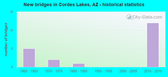
- New bridges - historical statistics
- 51960-1969
- 21970-1979
- 11980-1989
- 122010-2019


- Bridge Condition - Deck
- 87.5%Good
- 12.5%Satisfactory

- Bridge Condition - Superstructure
- 87.5%Very good
- 12.5%Satisfactory

- Bridge Condition - Substructure
- 50.0%Very good
- 50.0%Good

- Bridge Condition - Channel
- 80.0%Good
- 20.0%Fair
Find on map >> Show street view
Structure Number: 749, Location: 6.7 mi S Jct SR 69 (Lat: 34.236900, Lng: -112.111600), Route carried "on" structure: Interstate 17, Year Built: 1963, Status: Open, Structure Length: 2.74m (8.99ft), Average Daily Traffic: 19,903 (year 2018), Truck Traffic: 13%, Average Future Daily Traffic: 19,913 (year 2040), Design Load: HS 20, Features Intersected: Badger Springs Road
Minimum Vertical Clearance: 30+ m (98+ ft), Kilometerpoint: 412.073, Lanes on structure: 2, Lanes under structure: 2, Owner: State Highway Agency, Approaching Roadway Width: 11.6m (38.1ft), Material/Design: Concrete continuous, Design/Construction: Slab, Number Of Spans In Main Unit: 3, Length of Maximum Span: 10.1m (33.1ft), Curb-To-Curb Width: 11.6m (38.1ft), Out-to-Out Width: 13.2m (43.3ft)
Condition: Deck: Satisfactory, Superstructure: Satisfactory, Substructure: Good, Operating Rating: 57.2 metric tons, Method Used To Determine Operating Rating: Load Factor (LF), Inventory Rating: 34.5 metric tons, Method Used To Determine Inventory Rating: Load Factor (LF), Structural Evaluation: Equal to present minimum criteria, Deck Geometry: Equal to present minimum criteria, Underclear: High priority of corrective action, Approach Roadway Alignment: Equal to present desirable criteria, Designated Inspection Frequency: Every 24 months, Inspection Date: July 2020, Deck Structure Type: Concrete Cast-file-Place, Wearing Surface/Protective System: Wearing Surface: Bituminous
Find on map >> Show street view
Structure Number: 2938, Location: Jct SR 69 (Lat: 34.328100, Lng: -112.120900), Route carried "on" structure: Ramp Interstate 17, Year Built: 2012, Status: Open, Structure Length: 12.13m (39.80ft), Average Daily Traffic: 7,000 (year 2020), Truck Traffic: 10%, Average Future Daily Traffic: 7,010 (year 2040), Design Load: HS 25 or greater, Features Intersected: I-17, Facility Carried by Structure: Ramp N-N
Minimum Vertical Clearance: 30+ m (98+ ft), Kilometerpoint: 422.839, Lanes on structure: 2, Lanes under structure: 6, Owner: State Highway Agency, Approaching Roadway Width: 12.2m (40.0ft), Skew: 4 degrees, Material/Design: Prestressed concrete continuous, Design/Construction: Box Beam or Girders - Single/Spread, Number Of Spans In Main Unit: 2, Length of Maximum Span: 65.5m (214.9ft), Curb-To-Curb Width: 12.2m (40.0ft), Out-to-Out Width: 13.2m (43.3ft)
Condition: Deck: Good, Superstructure: Very good, Substructure: Very good, Operating Rating: 89.8 metric tons, Method Used To Determine Operating Rating: Load Factor (LF), Inventory Rating: 67.1 metric tons, Method Used To Determine Inventory Rating: Load Factor (LF), Structural Evaluation: Equal to present desirable criteria, Deck Geometry: Superior to present desirable criteria, Underclear: Meets minimum limits, Approach Roadway Alignment: Equal to present desirable criteria, Designated Inspection Frequency: Every 24 months, Inspection Date: July 2020, Deck Structure Type: Concrete Cast-file-Place, Wearing Surface/Protective System: Wearing Surface: Monolithic Concrete
Find on map >> Show street view
Structure Number: 2939, Location: 0.3 mi N Jct SR 69 (Lat: 34.333900, Lng: -112.120200), Route carried "on" structure: County highway , Year Built: 2012, Status: Open, Structure Length: 6.86m (22.51ft), Average Daily Traffic: 1,000 (year 2020), Truck Traffic: 2%, Average Future Daily Traffic: 1,010 (year 2040), Design Load: HS 20, Features Intersected: I-17, Facility Carried by Structure: Arcosanti Rd
Minimum Vertical Clearance: 30+ m (98+ ft), Kilometerpoint: 0.000, Lanes on structure: 4, Lanes under structure: 4, Owner: State Highway Agency, Approaching Roadway Width: 19.8m (65.0ft), Material/Design: Prestressed concrete continuous, Design/Construction: Stringer/Multi-beam, Number Of Spans In Main Unit: 2, Length of Maximum Span: 33.5m (109.9ft), Curb or Sidewalk Widths: Left: 0.0m, Right: 2.0m (6.6ft), Curb-To-Curb Width: 19.8m (65.0ft), Out-to-Out Width: 22.7m (74.5ft)
Condition: Deck: Good, Superstructure: Very good, Substructure: Good, Operating Rating: 89.8 metric tons, Method Used To Determine Operating Rating: Load Factor (LF), Inventory Rating: 44.5 metric tons, Method Used To Determine Inventory Rating: Load Factor (LF), Structural Evaluation: Better than present minimum criteria, Deck Geometry: Better than present minimum criteria, Underclear: Superior to present desirable criteria, Approach Roadway Alignment: Equal to present desirable criteria, Designated Inspection Frequency: Every 24 months, Inspection Date: July 2020, Deck Structure Type: Concrete Cast-file-Place, Wearing Surface/Protective System: Wearing Surface: Monolithic Concrete
Find on map >> Show street view
Structure Number: 2941, Location: Jct SR 69 (Lat: 34.329100, Lng: -112.120700), Route carried "on" structure: County highway , Year Built: 2012, Status: Open, Structure Length: 7.96m (26.12ft), Average Daily Traffic: 2,000 (year 2020), Truck Traffic: 5%, Average Future Daily Traffic: 2,010 (year 2040), Design Load: HS 25 or greater, Features Intersected: I-17, Facility Carried by Structure: Cordes Lakes Rd
Minimum Vertical Clearance: 30+ m (98+ ft), Kilometerpoint: 0.000, Lanes on structure: 2, Lanes under structure: 6, Owner: State Highway Agency, Approaching Roadway Width: 13.4m (44.0ft), Skew: 3 degrees, Material/Design: Prestressed concrete continuous, Design/Construction: Stringer/Multi-beam, Number Of Spans In Main Unit: 2, Length of Maximum Span: 38.7m (127.0ft), Curb-To-Curb Width: 13.4m (44.0ft), Out-to-Out Width: 14.4m (47.2ft)
Condition: Deck: Good, Superstructure: Very good, Substructure: Good, Operating Rating: 89.8 metric tons, Method Used To Determine Operating Rating: Load Factor (LF), Inventory Rating: 45.4 metric tons, Method Used To Determine Inventory Rating: Load Factor (LF), Structural Evaluation: Better than present minimum criteria, Deck Geometry: Equal to present desirable criteria, Underclear: Meets minimum limits, Approach Roadway Alignment: Equal to present desirable criteria, Designated Inspection Frequency: Every 24 months, Inspection Date: July 2020, Deck Structure Type: Concrete Cast-file-Place, Wearing Surface/Protective System: Wearing Surface: Monolithic Concrete
Find on map >> Show street view
Structure Number: 2942, Location: 0.3 mi W Jct I-17 (Lat: 34.332300, Lng: -112.125100), Route carried "on" structure: Ramp Interstate 17, Year Built: 2012, Status: Open, Structure Length: 4.11m (13.48ft), Average Daily Traffic: 7,000 (year 2020), Truck Traffic: 6%, Average Future Daily Traffic: 7,010 (year 2040), Design Load: HS 25 or greater, Features Intersected: Arcosanti Rd, Facility Carried by Structure: Ramp N-N
Minimum Vertical Clearance: 30+ m (98+ ft), Kilometerpoint: 423.225, Lanes on structure: 2, Lanes under structure: 2, Owner: State Highway Agency, Approaching Roadway Width: 12.2m (40.0ft), Material/Design: Prestressed concrete, Design/Construction: Box Beam or Girders - Single/Spread, Number Of Spans In Main Unit: 1, Length of Maximum Span: 39.6m (129.9ft), Curb-To-Curb Width: 12.2m (40.0ft), Out-to-Out Width: 13.1m (43.0ft)
Condition: Deck: Good, Superstructure: Very good, Substructure: Very good, Operating Rating: 85.3 metric tons, Method Used To Determine Operating Rating: Load Factor (LF), Inventory Rating: 50.8 metric tons, Method Used To Determine Inventory Rating: Load Factor (LF), Structural Evaluation: Equal to present desirable criteria, Deck Geometry: Superior to present desirable criteria, Underclear: Superior to present desirable criteria, Approach Roadway Alignment: Equal to present desirable criteria, Designated Inspection Frequency: Every 24 months, Inspection Date: July 2020, Deck Structure Type: Concrete Cast-file-Place, Wearing Surface/Protective System: Wearing Surface: Monolithic Concrete
Find on map >> Show street view
Structure Number: 2943, Location: 0.3 mi W Jct I-17 (Lat: 34.332100, Lng: -112.125300), Route carried "on" structure: Ramp Interstate 17, Year Built: 2012, Status: Open, Structure Length: 4.11m (13.48ft), Average Daily Traffic: 7,000 (year 2020), Truck Traffic: 6%, Average Future Daily Traffic: 7,010 (year 2040), Design Load: HS 25 or greater, Features Intersected: Arcosanti Rd, Facility Carried by Structure: Ramp S-S
Minimum Vertical Clearance: 30+ m (98+ ft), Kilometerpoint: 423.386, Lanes on structure: 1, Lanes under structure: 2, Owner: State Highway Agency, Approaching Roadway Width: 12.2m (40.0ft), Material/Design: Prestressed concrete, Design/Construction: Box Beam or Girders - Single/Spread, Number Of Spans In Main Unit: 1, Length of Maximum Span: 39.6m (129.9ft), Curb-To-Curb Width: 12.2m (40.0ft), Out-to-Out Width: 13.1m (43.0ft)
Condition: Deck: Good, Superstructure: Very good, Substructure: Very good, Operating Rating: 85.3 metric tons, Method Used To Determine Operating Rating: Load Factor (LF), Inventory Rating: 50.8 metric tons, Method Used To Determine Inventory Rating: Load Factor (LF), Structural Evaluation: Equal to present desirable criteria, Deck Geometry: Superior to present desirable criteria, Underclear: Superior to present desirable criteria, Approach Roadway Alignment: Equal to present desirable criteria, Designated Inspection Frequency: Every 24 months, Inspection Date: July 2020, Deck Structure Type: Concrete Cast-file-Place, Wearing Surface/Protective System: Wearing Surface: Monolithic Concrete
Find on map >> Show street view
Structure Number: 6634, Location: 11.8 mi S Jct I-40 (Lat: 34.317200, Lng: -112.104900), Route carried "on" structure: State highway 95, Year Built: 1977, Status: Open, Structure Length: 1.37m (4.49ft), Average Daily Traffic: 8,827 (year 2014), Truck Traffic: 18%, Average Future Daily Traffic: 8,837 (year 2036), Design Load: HS 20, Features Intersected: Dry Wash
Minimum Vertical Clearance: 30+ m (98+ ft), Kilometerpoint: 306.162, Lanes on structure: 3, Owner: State Highway Agency, Approaching Roadway Width: 17.1m (56.1ft), Skew: 3 degrees, Material/Design: Concrete continuous, Design/Construction: Culvert, Number Of Spans In Main Unit: 6, Length of Maximum Span: 1.8m (5.9ft)
Condition: Channel: Good, Culverts: Good, Operating Rating: 89.8 metric tons, Method Used To Determine Operating Rating: Load Factor (LF), Inventory Rating: 89.8 metric tons, Method Used To Determine Inventory Rating: Load Factor (LF), Structural Evaluation: Better than present minimum criteria, Waterway Adequacy: Equal to present minimum criteria, Approach Roadway Alignment: Equal to present desirable criteria, Length Of Structure Improvement: 2.13m (6.99ft), Designated Inspection Frequency: Every 48 months, Inspection Date: Febuary 2020, Total Project Cost: $1,000 ( Estimate for 2016)
Find on map >> Show street view
Structure Number: 8623, Location: 2.4 mi SE of Jct I 17 (Lat: 34.300528, Lng: -112.104861), Route carried "on" structure: County highway , Year Built: 1979, Status: Open, Structure Length: 2.23m (7.32ft), Average Daily Traffic: 310 (year 2019), Truck Traffic: 1%, Average Future Daily Traffic: 320 (year 2039), Design Load: HS 20, Features Intersected: Big Bug Creek, Facility Carried by Structure: Cordes Lakes Drive
Minimum Vertical Clearance: 30+ m (98+ ft), Kilometerpoint: 0.000, Lanes on structure: 2, Owner: County Highway Agency, Approaching Roadway Width: 7.3m (24.0ft), Skew: 4 degrees, Material/Design: Concrete continuous, Design/Construction: Culvert, Number Of Spans In Main Unit: 4, Length of Maximum Span: 3.7m (12.1ft), Curb or Sidewalk Widths: Left: 0.3m (1.0ft), Right: 0.3m (1.0ft), Curb-To-Curb Width: 8.8m (28.9ft), Out-to-Out Width: 9.4m (30.8ft)
Condition: Channel: Good, Culverts: Good, Operating Rating: 53.5 metric tons, Method Used To Determine Operating Rating: Load Factor (LF), Inventory Rating: 31.8 metric tons, Method Used To Determine Inventory Rating: Load Factor (LF), Structural Evaluation: Better than present minimum criteria, Deck Geometry: Equal to present minimum criteria, Waterway Adequacy: Better than present minimum criteria, Approach Roadway Alignment: Somewhat better than minimum adequacy, Designated Inspection Frequency: Every 48 months, Inspection Date: July 2019, Deck Structure Type: Concrete Cast-file-Place, Wearing Surface/Protective System: Wearing Surface: Monolithic Concrete
Find on map >> Show street view
Structure Number: 10707, Location: W of S Brahma Dr (Lat: 34.304583, Lng: -112.113611), Route carried "on" structure: County highway , Year Built: 1980, Status: Open, Structure Length: 0.85m (2.79ft), Average Daily Traffic: 110 (year 2019), Truck Traffic: 1%, Average Future Daily Traffic: 120 (year 2039), Design Load: HS 20, Features Intersected: Unnamed Wash, Facility Carried by Structure: Fremont Dr
Minimum Vertical Clearance: 30+ m (98+ ft), Kilometerpoint: 0.000, Lanes on structure: 2, Owner: County Highway Agency, Approaching Roadway Width: 7.3m (24.0ft), Material/Design: Steel, Design/Construction: Culvert, Number Of Spans In Main Unit: 4, Length of Maximum Span: 1.5m (4.9ft)
Condition: Channel: Fair, Culverts: Good, Operating Rating: 89.8 metric tons, Method Used To Determine Operating Rating: Load Factor (LF), Inventory Rating: 89.8 metric tons, Method Used To Determine Inventory Rating: Load Factor (LF), Structural Evaluation: Better than present minimum criteria, Waterway Adequacy: Equal to present minimum criteria, Approach Roadway Alignment: Somewhat better than minimum adequacy, Designated Inspection Frequency: Every 48 months, Inspection Date: July 2019
Find on map >> Show street view
Structure Number: 20027, Location: 0.7 mi S Jct SR 69 (Lat: 34.320100, Lng: -112.122900), Route carried "on" structure: Interstate 17, Year Built: 2012, Status: Open, Structure Length: 8.29m (27.20ft), Average Daily Traffic: 16,351 (year 2018), Truck Traffic: 16%, Average Future Daily Traffic: 16,361 (year 2040), Design Load: HS 25 or greater, Features Intersected: Big Bug Creek
Minimum Vertical Clearance: 30+ m (98+ ft), Kilometerpoint: 421.729, Lanes on structure: 4, Owner: State Highway Agency, Approaching Roadway Width: 27.4m (89.9ft), Skew: 1 degrees, Material/Design: Prestressed concrete continuous, Design/Construction: Stringer/Multi-beam, Number Of Spans In Main Unit: 3, Length of Maximum Span: 27.4m (89.9ft), Curb-To-Curb Width: 28.7m (94.2ft), Out-to-Out Width: 29.7m (97.4ft)
Condition: Deck: Good, Superstructure: Very good, Substructure: Very good, Channel: Good, Operating Rating: 78.0 metric tons, Method Used To Determine Operating Rating: Load Factor (LF), Inventory Rating: 43.5 metric tons, Method Used To Determine Inventory Rating: Load Factor (LF), Structural Evaluation: Equal to present desirable criteria, Deck Geometry: Superior to present desirable criteria, Waterway Adequacy: Equal to present desirable criteria, Approach Roadway Alignment: Equal to present desirable criteria, Designated Inspection Frequency: Every 24 months, Inspection Date: July 2020, Deck Structure Type: Concrete Cast-file-Place, Wearing Surface/Protective System: Wearing Surface: Monolithic Concrete
Find on map >> Show street view
Structure Number: 20028, Location: 0.7 mi S Jct SR 69 (Lat: 34.320300, Lng: -112.123300), Route carried "on" structure: Interstate 17, Year Built: 2012, Status: Open, Structure Length: 8.29m (27.20ft), Average Daily Traffic: 16,351 (year 2018), Truck Traffic: 16%, Average Future Daily Traffic: 16,361 (year 2040), Design Load: HS 25 or greater, Features Intersected: Big Bug Creek
Minimum Vertical Clearance: 30+ m (98+ ft), Kilometerpoint: 421.729, Lanes on structure: 2, Owner: State Highway Agency, Approaching Roadway Width: 17.1m (56.1ft), Skew: 1 degrees, Material/Design: Prestressed concrete continuous, Design/Construction: Stringer/Multi-beam, Number Of Spans In Main Unit: 3, Length of Maximum Span: 27.4m (89.9ft), Curb-To-Curb Width: 18.3m (60.0ft), Out-to-Out Width: 19.2m (63.0ft)
Condition: Deck: Good, Superstructure: Very good, Substructure: Good, Channel: Good, Operating Rating: 78.0 metric tons, Method Used To Determine Operating Rating: Load Factor (LF), Inventory Rating: 43.5 metric tons, Method Used To Determine Inventory Rating: Load Factor (LF), Structural Evaluation: Better than present minimum criteria, Deck Geometry: Superior to present desirable criteria, Waterway Adequacy: Equal to present desirable criteria, Approach Roadway Alignment: Equal to present desirable criteria, Designated Inspection Frequency: Every 24 months, Inspection Date: July 2020, Deck Structure Type: Concrete Cast-file-Place, Wearing Surface/Protective System: Wearing Surface: Monolithic Concrete
Find on map >> Show street view
Structure Number: 749, Location: 6.7 mi S Jct SR 69 (Lat: 34.236900, Lng: -112.111600), Route carried "under" structure: County highway , Year Built: 1963, Structure Length: 0. m, Average Daily Traffic: 250 (year 2020), Truck Traffic: 2%, Features Intersected: Badger Springs Road, Facility Carried by Structure: I-17 NB
Minimum Vertical Clearance: 4.68m (15.35ft), Kilometerpoint: 0.000, Lanes on structure: 2, Lanes under structure: 2, Material/Design: Concrete continuous, Design/Construction: Slab, Length of Maximum Span: 10.1m (33.1ft)
Find on map >> Show street view
Structure Number: 75, Location: 6.8 mi S Jct SR 69 (Lat: 34.235700, Lng: -112.116900), Route carried "under" structure: County highway , Year Built: 1963, Structure Length: 0. m, Average Daily Traffic: 250 (year 2020), Truck Traffic: 2%, Features Intersected: Badger Springs Road, Facility Carried by Structure: I-17 SB
Minimum Vertical Clearance: 4.94m (16.21ft), Kilometerpoint: 0.000, Lanes on structure: 2, Lanes under structure: 2, Material/Design: Concrete continuous, Design/Construction: Slab, Length of Maximum Span: 10.1m (33.1ft)
Find on map >> Show street view
Structure Number: 751, Location: 3.3 mi S Jct SR 69 (Lat: 34.284100, Lng: -112.120500), Route carried "under" structure: County highway , Year Built: 1963, Structure Length: 0. m, Average Daily Traffic: 250 (year 2020), Truck Traffic: 2%, Features Intersected: Bloody Basin Rd, Facility Carried by Structure: I-17 NB
Minimum Vertical Clearance: 4.67m (15.32ft), Kilometerpoint: 0.000, Lanes on structure: 2, Lanes under structure: 2, Material/Design: Concrete continuous, Design/Construction: Slab, Length of Maximum Span: 10.1m (33.1ft)
Find on map >> Show street view
Structure Number: 752, Location: 3.3 mi S Jct SR 69 (Lat: 34.284000, Lng: -112.120800), Route carried "under" structure: County highway , Year Built: 1964, Structure Length: 0. m, Average Daily Traffic: 200 (year 2020), Truck Traffic: 1%, Features Intersected: Bloody Basin Rd, Facility Carried by Structure: I-17 SB
Minimum Vertical Clearance: 4.89m (16.04ft), Kilometerpoint: 0.000, Lanes on structure: 2, Lanes under structure: 2, Material/Design: Concrete continuous, Design/Construction: Slab, Length of Maximum Span: 10.1m (33.1ft)
Find on map >> Show street view
Structure Number: 2938, Location: Jct SR 69 (Lat: 34.328100, Lng: -112.120900), Route carried "under" structure: Interstate 17, Year Built: 2012, Structure Length: 0. m, Average Daily Traffic: 21,634 (year 2018), Truck Traffic: 18%, Features Intersected: I-17, Facility Carried by Structure: Ramp N-N
Minimum Vertical Clearance: 6.90m (22.64ft), Kilometerpoint: 422.678, Lanes on structure: 2, Lanes under structure: 6, Material/Design: Prestressed concrete continuous, Design/Construction: Box Beam or Girders - Single/Spread, Length of Maximum Span: 65.5m (214.9ft)
Find on map >> Show street view
Structure Number: 2939, Location: 0.3 mi N Jct SR 69 (Lat: 34.333900, Lng: -112.120200), Route carried "under" structure: Interstate 17, Year Built: 2012, Structure Length: 0. m, Average Daily Traffic: 21,634 (year 2018), Truck Traffic: 24%, Features Intersected: I-17, Facility Carried by Structure: Arcosanti Rd
Minimum Vertical Clearance: 5.79m (19.00ft), Kilometerpoint: 423.257, Lanes on structure: 4, Lanes under structure: 4, Material/Design: Prestressed concrete continuous, Design/Construction: Stringer/Multi-beam, Length of Maximum Span: 33.5m (109.9ft)
Find on map >> Show street view
Structure Number: 2941, Location: Jct SR 69 (Lat: 34.329100, Lng: -112.120700), Route carried "under" structure: Interstate 17, Year Built: 2012, Structure Length: 0. m, Average Daily Traffic: 21,634 (year 2018), Truck Traffic: 18%, Features Intersected: I-17, Facility Carried by Structure: Cordes Lakes Rd
Minimum Vertical Clearance: 6.04m (19.82ft), Kilometerpoint: 422.742, Lanes on structure: 2, Lanes under structure: 6, Material/Design: Prestressed concrete continuous, Design/Construction: Stringer/Multi-beam, Length of Maximum Span: 38.7m (127.0ft)
Find on map >> Show street view
Structure Number: 2942, Location: 0.3 mi W Jct I-17 (Lat: 34.332300, Lng: -112.125100), Route carried "under" structure: County highway , Year Built: 2012, Structure Length: 0. m, Average Daily Traffic: 1,000 (year 2020), Truck Traffic: 5%, Features Intersected: Arcosanti Rd, Facility Carried by Structure: Ramp N-N
Minimum Vertical Clearance: 5.92m (19.42ft), Kilometerpoint: 0.000, Lanes on structure: 2, Lanes under structure: 2, Material/Design: Prestressed concrete, Design/Construction: Box Beam or Girders - Single/Spread, Length of Maximum Span: 39.6m (129.9ft)
Find on map >> Show street view
Structure Number: 2943, Location: 0.3 mi W Jct I-17 (Lat: 34.332100, Lng: -112.125300), Route carried "under" structure: County highway , Year Built: 2012, Structure Length: 0. m, Average Daily Traffic: 1,000 (year 2020), Truck Traffic: 5%, Features Intersected: Arcosanti Rd, Facility Carried by Structure: Ramp S-S
Minimum Vertical Clearance: 5.18m (16.99ft), Kilometerpoint: 0.000, Lanes on structure: 1, Lanes under structure: 2, Material/Design: Prestressed concrete, Design/Construction: Box Beam or Girders - Single/Spread, Length of Maximum Span: 39.6m (129.9ft)