Bridge Statistics for Coral Springs, Florida (FL)
Condition, Traffic, Stress, Structural Evaluation, Project Costs
- National Bridge Inventory (NBI) Statistics
- 38Number of bridges
- 318ft / 97.0mTotal length
- 795,812Total average daily traffic
- 49,547Total average daily truck traffic
- National Bridge Inventory (NBI) Registered Bridges for Coral Springs
- No street view available for this location
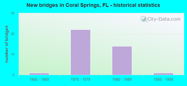
- New bridges - historical statistics
- 11960-1969
- 221970-1979
- 141980-1989
- 11990-1999
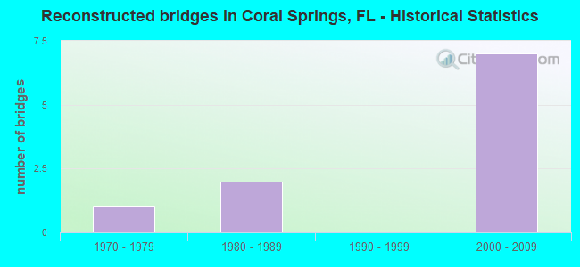
- Reconstructed bridges - Historical Statistics
- 11970-1979
- 21980-1989
- 01990-1999
- 72000-2009
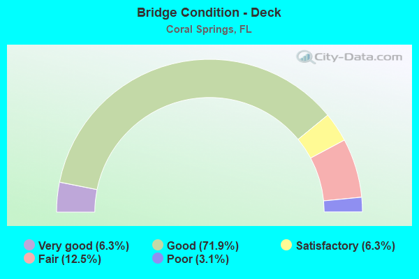
- Bridge Condition - Deck
- 6.3%Very good
- 71.9%Good
- 6.3%Satisfactory
- 12.5%Fair
- 3.1%Poor
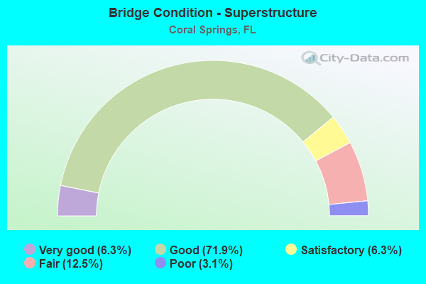
- Bridge Condition - Superstructure
- 6.3%Very good
- 71.9%Good
- 6.3%Satisfactory
- 12.5%Fair
- 3.1%Poor
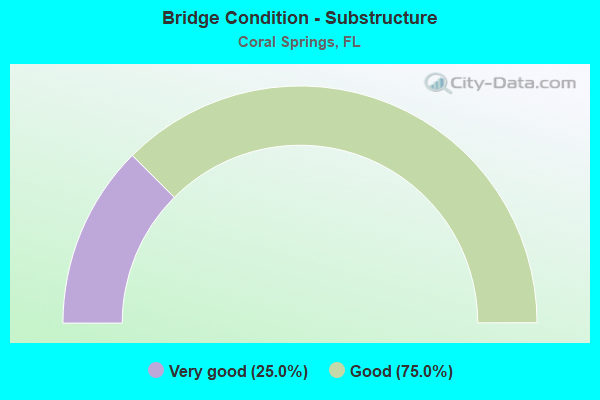
- Bridge Condition - Substructure
- 25.0%Very good
- 75.0%Good
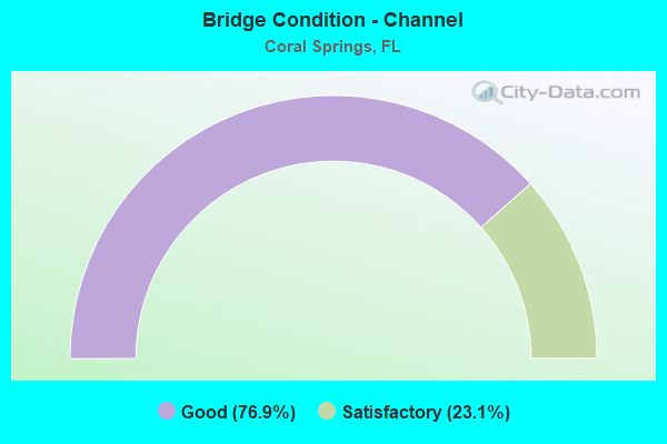
- Bridge Condition - Channel
- 76.9%Good
- 23.1%Satisfactory
Find on map >> Show street view
Structure Number: 860362, Location: .4M N of Atlantic Blvd. (Lat: 26.246472, Lng: -80.253044), Route carried "on" structure: State highway 817, Year Built: 1974, Year Reconstructed: 1992, Status: Open, Structure Length: 1.83m (6.00ft), Average Daily Traffic: 20,750 (year 2021), Truck Traffic: 3%, Average Future Daily Traffic: 36,001 (year 2042), Design Load: HS 20+Mod, Features Intersected: Canal L-106, Facility Carried by Structure: NB University Dr.
Minimum Vertical Clearance: 30+ m (98+ ft), Kilometerpoint: 30.867, Lanes on structure: 3, Base Highway Network: Yes, Owner: State Highway Agency, Approaching Roadway Width: 12.2m (40.0ft), Material/Design: Prestressed concrete, Design/Construction: Slab, Number Of Spans In Main Unit: 2, Length of Maximum Span: 9.1m (29.9ft), Curb or Sidewalk Widths: Left: 0.0m, Right: 1.5m (4.9ft), Curb-To-Curb Width: 12.2m (40.0ft), Out-to-Out Width: 14.4m (47.2ft)
Condition: Deck: Good, Superstructure: Good, Substructure: Good, Channel: Good, Operating Rating: 73.5 metric tons, Method Used To Determine Operating Rating: Load Factor (LF), Inventory Rating: 43.5 metric tons, Method Used To Determine Inventory Rating: Load Factor (LF), Structural Evaluation: Better than present minimum criteria, Deck Geometry: Meets minimum limits, Waterway Adequacy: Superior to present desirable criteria, Approach Roadway Alignment: Equal to present desirable criteria, Designated Inspection Frequency: Every 24 months, Underwater Inspection Frequency: Every 24 months, Inspection Date: September 2021, Underwater Inspection Date: September 2021, Deck Structure Type: Concrete Precast Panels, Wearing Surface/Protective System: Wearing Surface: Bituminous
Find on map >> Show street view
Structure Number: 860363, Location: 0.5 MI So of W Atlantic (Lat: 26.237681, Lng: -80.254683), Route carried "on" structure: State highway 817, Year Built: 1974, Status: Open, Structure Length: 1.83m (6.00ft), Average Daily Traffic: 19,500 (year 2021), Truck Traffic: 3%, Average Future Daily Traffic: 33,832 (year 2042), Design Load: HS 20+Mod, Features Intersected: Canal L-104
Minimum Vertical Clearance: 30+ m (98+ ft), Kilometerpoint: 29.876, Lanes on structure: 3, Base Highway Network: Yes, Owner: State Highway Agency, Approaching Roadway Width: 11.0m (36.1ft), Material/Design: Prestressed concrete, Design/Construction: Slab, Number Of Spans In Main Unit: 2, Length of Maximum Span: 9.1m (29.9ft), Curb or Sidewalk Widths: Left: 0.0m, Right: 1.6m (5.2ft), Curb-To-Curb Width: 12.2m (40.0ft), Out-to-Out Width: 14.4m (47.2ft)
Condition: Deck: Fair, Superstructure: Fair, Substructure: Very good, Channel: Satisfactory, Operating Rating: 70.5 metric tons, Method Used To Determine Operating Rating: Load Factor (LF), Inventory Rating: 42.3 metric tons, Method Used To Determine Inventory Rating: Load Factor (LF), Structural Evaluation: Somewhat better than minimum adequacy, Deck Geometry: Meets minimum limits, Waterway Adequacy: Superior to present desirable criteria, Approach Roadway Alignment: Equal to present desirable criteria, Designated Inspection Frequency: Every 24 months, Underwater Inspection Frequency: Every 24 months, Inspection Date: August 2021, Underwater Inspection Date: August 2021, Deck Structure Type: Concrete Precast Panels, Wearing Surface/Protective System: Wearing Surface: Bituminous
Find on map >> Show street view
Structure Number: 860364, Location: 0.3mi. S of Riverside Dr. (Lat: 26.232767, Lng: -80.252997), Route carried "on" structure: State highway 817, Year Built: 1974, Status: Open, Structure Length: 1.83m (6.00ft), Average Daily Traffic: 19,500 (year 2021), Truck Traffic: 3%, Average Future Daily Traffic: 33,832 (year 2042), Design Load: HS 20, Features Intersected: Canal L102, Facility Carried by Structure: NB University Dr.
Minimum Vertical Clearance: 30+ m (98+ ft), Kilometerpoint: 29.303, Lanes on structure: 3, Base Highway Network: Yes, Owner: State Highway Agency, Approaching Roadway Width: 12.2m (40.0ft), Material/Design: Prestressed concrete, Design/Construction: Slab, Number Of Spans In Main Unit: 2, Length of Maximum Span: 9.1m (29.9ft), Curb or Sidewalk Widths: Left: 0.0m, Right: 1.6m (5.2ft), Curb-To-Curb Width: 12.2m (40.0ft), Out-to-Out Width: 14.4m (47.2ft)
Condition: Deck: Good, Superstructure: Good, Substructure: Good, Channel: Satisfactory, Operating Rating: 68.5 metric tons, Method Used To Determine Operating Rating: Load Factor (LF), Inventory Rating: 41.1 metric tons, Method Used To Determine Inventory Rating: Load Factor (LF), Structural Evaluation: Better than present minimum criteria, Deck Geometry: Meets minimum limits, Waterway Adequacy: Superior to present desirable criteria, Approach Roadway Alignment: Equal to present desirable criteria, Designated Inspection Frequency: Every 24 months, Underwater Inspection Frequency: Every 24 months, Inspection Date: August 2021, Underwater Inspection Date: August 2021, Deck Structure Type: Concrete Precast Panels, Wearing Surface/Protective System: Wearing Surface: Bituminous
Find on map >> Show street view
Structure Number: 860365, Location: .4 mi N of Atlantic Blvd. (Lat: 26.246628, Lng: -80.253342), Route carried "on" structure: State highway 817, Year Built: 1974, Year Reconstructed: 1992, Status: Open, Structure Length: 1.83m (6.00ft), Average Daily Traffic: 20,750 (year 2021), Truck Traffic: 3%, Average Future Daily Traffic: 36,001 (year 2042), Design Load: HS 20+Mod, Features Intersected: Canal L-106, Facility Carried by Structure: SB University Dr.
Minimum Vertical Clearance: 30+ m (98+ ft), Kilometerpoint: 30.867, Lanes on structure: 3, Base Highway Network: Yes, Owner: State Highway Agency, Approaching Roadway Width: 12.2m (40.0ft), Material/Design: Prestressed concrete, Design/Construction: Slab, Number Of Spans In Main Unit: 2, Length of Maximum Span: 9.1m (29.9ft), Curb or Sidewalk Widths: Left: 1.5m (4.9ft), Right: 0.0m, Curb-To-Curb Width: 14.4m (47.2ft), Out-to-Out Width: 17.2m (56.4ft)
Condition: Deck: Good, Superstructure: Good, Substructure: Good, Channel: Good, Operating Rating: 62.1 metric tons, Method Used To Determine Operating Rating: Load Factor (LF), Inventory Rating: 37.2 metric tons, Method Used To Determine Inventory Rating: Load Factor (LF), Structural Evaluation: Better than present minimum criteria, Deck Geometry: Somewhat better than minimum adequacy, Waterway Adequacy: Superior to present desirable criteria, Approach Roadway Alignment: Equal to present desirable criteria, Designated Inspection Frequency: Every 24 months, Underwater Inspection Frequency: Every 24 months, Inspection Date: September 2021, Underwater Inspection Date: September 2021, Deck Structure Type: Concrete Precast Panels, Wearing Surface/Protective System: Wearing Surface: Bituminous
Find on map >> Show street view
Structure Number: 860366, Location: .5Mi S of W Atlantic Blvd (Lat: 26.237831, Lng: -80.254986), Route carried "on" structure: State highway 817, Year Built: 1974, Status: Open, Structure Length: 1.83m (6.00ft), Average Daily Traffic: 19,500 (year 2021), Truck Traffic: 3%, Average Future Daily Traffic: 33,832 (year 2042), Design Load: HS 20+Mod, Features Intersected: Canal L-104
Minimum Vertical Clearance: 30+ m (98+ ft), Kilometerpoint: 29.876, Lanes on structure: 3, Base Highway Network: Yes, Owner: State Highway Agency, Approaching Roadway Width: 11.0m (36.1ft), Material/Design: Prestressed concrete, Design/Construction: Slab, Number Of Spans In Main Unit: 2, Length of Maximum Span: 9.1m (29.9ft), Curb or Sidewalk Widths: Left: 1.6m (5.2ft), Right: 0.0m, Curb-To-Curb Width: 12.2m (40.0ft), Out-to-Out Width: 14.4m (47.2ft)
Condition: Deck: Fair, Superstructure: Fair, Substructure: Good, Channel: Satisfactory, Operating Rating: 70.5 metric tons, Method Used To Determine Operating Rating: Load Factor (LF), Inventory Rating: 42.3 metric tons, Method Used To Determine Inventory Rating: Load Factor (LF), Structural Evaluation: Somewhat better than minimum adequacy, Deck Geometry: Meets minimum limits, Waterway Adequacy: Superior to present desirable criteria, Approach Roadway Alignment: Equal to present desirable criteria, Designated Inspection Frequency: Every 24 months, Underwater Inspection Frequency: Every 24 months, Inspection Date: August 2021, Underwater Inspection Date: August 2021, Deck Structure Type: Concrete Precast Panels, Wearing Surface/Protective System: Wearing Surface: Bituminous
Find on map >> Show street view
Structure Number: 860367, Location: 0.3mi. S of Riverside Dr. (Lat: 26.232856, Lng: -80.253339), Route carried "on" structure: State highway 817, Year Built: 1974, Status: Open, Structure Length: 1.83m (6.00ft), Average Daily Traffic: 19,500 (year 2021), Truck Traffic: 3%, Average Future Daily Traffic: 33,832 (year 2042), Design Load: HS 20, Features Intersected: Canal L102, Facility Carried by Structure: SB University Dr.
Minimum Vertical Clearance: 30+ m (98+ ft), Kilometerpoint: 29.303, Lanes on structure: 3, Base Highway Network: Yes, Owner: State Highway Agency, Approaching Roadway Width: 12.2m (40.0ft), Material/Design: Prestressed concrete, Design/Construction: Slab, Number Of Spans In Main Unit: 2, Length of Maximum Span: 9.1m (29.9ft), Curb or Sidewalk Widths: Left: 1.6m (5.2ft), Right: 0.0m, Curb-To-Curb Width: 12.2m (40.0ft), Out-to-Out Width: 14.4m (47.2ft)
Condition: Deck: Poor, Superstructure: Poor, Substructure: Good, Channel: Satisfactory, Operating Rating: 70.5 metric tons, Method Used To Determine Operating Rating: Load Factor (LF), Inventory Rating: 42.3 metric tons, Method Used To Determine Inventory Rating: Load Factor (LF), Structural Evaluation: Meets minimum limits, Deck Geometry: Meets minimum limits, Waterway Adequacy: Superior to present desirable criteria, Approach Roadway Alignment: Equal to present desirable criteria, Designated Inspection Frequency: Every 24 months, Underwater Inspection Frequency: Every 24 months, Other Special Inspection Frequency: Every 12 months, Inspection Date: August 2021, Underwater Inspection Date: August 2021, Other Special Inspection Date: August 2021, Deck Structure Type: Concrete Precast Panels, Wearing Surface/Protective System: Wearing Surface: Bituminous
Find on map >> Show street view
Structure Number: 860488, Location: INTER SR-814 AND SR-869 (Lat: 26.233258, Lng: -80.295964), Route carried "on" structure: State highway 869, Year Built: 1986, Year Reconstructed: 2008, Status: Open, Structure Length: 4.88m (16.01ft), Average Daily Traffic: 36,650 (year 2022), Truck Traffic: 8%, Average Future Daily Traffic: 63,588 (year 2042), Design Load: HL 93, Features Intersected: SR 814 ATLANTIC BLVD
Minimum Vertical Clearance: 30+ m (98+ ft), Kilometerpoint: 13.179, Lanes on structure: 3, Lanes under structure: 4, Base Highway Network: Yes, Toll: On toll road, Owner: State Toll Authority, Approaching Roadway Width: 23.2m (76.1ft), Material/Design: Prestressed concrete, Design/Construction: Stringer/Multi-beam, Number Of Spans In Main Unit: 2, Length of Maximum Span: 24.7m (81.0ft), Curb-To-Curb Width: 17.9m (58.7ft), Out-to-Out Width: 18.0m (59.1ft)
Condition: Deck: Good, Superstructure: Good, Substructure: Very good, Operating Rating: 47.4 metric tons, Method Used To Determine Operating Rating: Load and Resistance Factor (LRFR), Inventory Rating: 42.1 metric tons, Method Used To Determine Inventory Rating: Load and Resistance Factor (LRFR), Structural Evaluation: Better than present minimum criteria, Deck Geometry: Better than present minimum criteria, Underclear: Equal to present minimum criteria, Approach Roadway Alignment: Equal to present desirable criteria, Designated Inspection Frequency: Every 24 months, Inspection Date: January 2022, Deck Structure Type: Concrete Cast-file-Place
Find on map >> Show street view
Structure Number: 860489, Location: INTERS SR-814 AND SR-869 (Lat: 26.233242, Lng: -80.296344), Route carried "on" structure: State highway 869, Year Built: 1986, Year Reconstructed: 2008, Status: Open, Structure Length: 4.88m (16.01ft), Average Daily Traffic: 36,650 (year 2022), Truck Traffic: 8%, Average Future Daily Traffic: 63,588 (year 2042), Design Load: HL 93, Features Intersected: SR 814 ATLANTIC BLVD
Minimum Vertical Clearance: 30+ m (98+ ft), Kilometerpoint: 13.179, Lanes on structure: 3, Lanes under structure: 4, Base Highway Network: Yes, Toll: On toll road, Owner: State Toll Authority, Approaching Roadway Width: 17.1m (56.1ft), Material/Design: Prestressed concrete, Design/Construction: Stringer/Multi-beam, Number Of Spans In Main Unit: 2, Length of Maximum Span: 24.7m (81.0ft), Curb-To-Curb Width: 17.1m (56.1ft), Out-to-Out Width: 18.0m (59.1ft)
Condition: Deck: Good, Superstructure: Good, Substructure: Very good, Operating Rating: 47.4 metric tons, Method Used To Determine Operating Rating: Load and Resistance Factor (LRFR), Inventory Rating: 42.1 metric tons, Method Used To Determine Inventory Rating: Load and Resistance Factor (LRFR), Structural Evaluation: Better than present minimum criteria, Deck Geometry: Equal to present minimum criteria, Underclear: Equal to present minimum criteria, Approach Roadway Alignment: Equal to present desirable criteria, Designated Inspection Frequency: Every 24 months, Inspection Date: January 2022, Deck Structure Type: Concrete Cast-file-Place
Find on map >> Show street view
Structure Number: 86049, Location: INTER SR-834 AND SR-869 (Lat: 26.273006, Lng: -80.296475), Route carried "on" structure: State highway 869, Year Built: 1986, Year Reconstructed: 2008, Status: Open, Structure Length: 4.88m (16.01ft), Average Daily Traffic: 31,300 (year 2022), Truck Traffic: 8%, Average Future Daily Traffic: 54,306 (year 2042), Design Load: HL 93, Features Intersected: SR 834 SAMPLE RD
Minimum Vertical Clearance: 30+ m (98+ ft), Kilometerpoint: 17.587, Lanes on structure: 3, Lanes under structure: 4, Base Highway Network: Yes, Toll: On toll road, Owner: State Toll Authority, Approaching Roadway Width: 17.1m (56.1ft), Material/Design: Prestressed concrete, Design/Construction: Stringer/Multi-beam, Number Of Spans In Main Unit: 2, Length of Maximum Span: 24.7m (81.0ft), Curb-To-Curb Width: 17.1m (56.1ft), Out-to-Out Width: 18.0m (59.1ft)
Condition: Deck: Good, Superstructure: Good, Substructure: Very good, Operating Rating: 47.4 metric tons, Method Used To Determine Operating Rating: Load and Resistance Factor (LRFR), Inventory Rating: 42.1 metric tons, Method Used To Determine Inventory Rating: Load and Resistance Factor (LRFR), Structural Evaluation: Better than present minimum criteria, Deck Geometry: Equal to present minimum criteria, Underclear: Equal to present minimum criteria, Approach Roadway Alignment: Equal to present desirable criteria, Designated Inspection Frequency: Every 24 months, Inspection Date: January 2022, Deck Structure Type: Concrete Cast-file-Place
Find on map >> Show street view
Structure Number: 860491, Location: INTER SR-834 AND SR-869 (Lat: 26.273017, Lng: -80.296858), Route carried "on" structure: State highway 869, Year Built: 1986, Year Reconstructed: 2008, Status: Open, Structure Length: 4.94m (16.21ft), Average Daily Traffic: 31,300 (year 2022), Truck Traffic: 8%, Average Future Daily Traffic: 54,306 (year 2042), Design Load: HL 93, Features Intersected: SR 834 SAMPLE RD
Minimum Vertical Clearance: 30+ m (98+ ft), Kilometerpoint: 17.587, Lanes on structure: 3, Lanes under structure: 4, Base Highway Network: Yes, Toll: On toll road, Owner: State Toll Authority, Approaching Roadway Width: 17.0m (55.8ft), Material/Design: Prestressed concrete, Design/Construction: Stringer/Multi-beam, Number Of Spans In Main Unit: 2, Length of Maximum Span: 24.7m (81.0ft), Curb-To-Curb Width: 17.0m (55.8ft), Out-to-Out Width: 18.0m (59.1ft)
Condition: Deck: Good, Superstructure: Good, Substructure: Very good, Operating Rating: 47.4 metric tons, Method Used To Determine Operating Rating: Load and Resistance Factor (LRFR), Inventory Rating: 42.1 metric tons, Method Used To Determine Inventory Rating: Load and Resistance Factor (LRFR), Structural Evaluation: Better than present minimum criteria, Deck Geometry: Equal to present minimum criteria, Underclear: Equal to present minimum criteria, Approach Roadway Alignment: Equal to present desirable criteria, Designated Inspection Frequency: Every 24 months, Inspection Date: January 2022, Deck Structure Type: Concrete Cast-file-Place
Find on map >> Show street view
Structure Number: 860492, Location: 1.5MI N OF SR-834 SAMP.RD (Lat: 26.287725, Lng: -80.297186), Route carried "on" structure: State highway 869, Year Built: 1986, Year Reconstructed: 2008, Status: Open, Structure Length: 3.35m (10.99ft), Average Daily Traffic: 62,600 (year 2020), Truck Traffic: 8%, Average Future Daily Traffic: 108,611 (year 2042), Design Load: HL 93, Features Intersected: C-5 CANAL
Minimum Vertical Clearance: 30+ m (98+ ft), Kilometerpoint: 19.230, Lanes on structure: 6, Base Highway Network: Yes, Toll: On toll road, Owner: State Toll Authority, Approaching Roadway Width: 34.1m (111.9ft), Skew: 10 degrees, Material/Design: Prestressed concrete, Design/Construction: Slab, Number Of Spans In Main Unit: 3, Length of Maximum Span: 11.3m (37.1ft), Curb-To-Curb Width: 34.1m (111.9ft), Out-to-Out Width: 36.0m (118.1ft)
Condition: Deck: Good, Superstructure: Good, Substructure: Good, Channel: Good, Operating Rating: 57.5 metric tons, Method Used To Determine Operating Rating: Load and Resistance Factor (LRFR), Inventory Rating: 44.5 metric tons, Method Used To Determine Inventory Rating: Load and Resistance Factor (LRFR), Structural Evaluation: Better than present minimum criteria, Deck Geometry: Superior to present desirable criteria, Waterway Adequacy: Equal to present desirable criteria, Approach Roadway Alignment: Equal to present desirable criteria, Designated Inspection Frequency: Every 24 months, Underwater Inspection Frequency: Every 24 months, Inspection Date: January 2022, Underwater Inspection Date: January 2022, Deck Structure Type: Concrete Precast Panels, Wearing Surface/Protective System: Wearing Surface: Bituminous
Find on map >> Show street view
Structure Number: 860494, Location: INTER SR-869 & CORL RDG D (Lat: 26.302078, Lng: -80.278792), Route carried "on" structure: State highway 869, Year Built: 1986, Year Reconstructed: 2007, Status: Open, Structure Length: 6.74m (22.11ft), Average Daily Traffic: 33,750 (year 2020), Truck Traffic: 8%, Average Future Daily Traffic: 58,556 (year 2042), Design Load: HL 93, Features Intersected: CORAL RIDGE DR
Minimum Vertical Clearance: 30+ m (98+ ft), Kilometerpoint: 22.268, Lanes on structure: 3, Lanes under structure: 6, Base Highway Network: Yes, Toll: On toll road, Owner: State Toll Authority, Approaching Roadway Width: 16.8m (55.1ft), Material/Design: Prestressed concrete, Design/Construction: Stringer/Multi-beam, Number Of Spans In Main Unit: 2, Length of Maximum Span: 33.7m (110.6ft), Curb-To-Curb Width: 16.8m (55.1ft), Out-to-Out Width: 18.0m (59.1ft)
Condition: Deck: Good, Superstructure: Good, Substructure: Very good, Operating Rating: 65.0 metric tons, Method Used To Determine Operating Rating: Load Factor (LF), Inventory Rating: 39.0 metric tons, Method Used To Determine Inventory Rating: Load Factor (LF), Structural Evaluation: Better than present minimum criteria, Deck Geometry: Equal to present minimum criteria, Underclear: Superior to present desirable criteria, Approach Roadway Alignment: Equal to present desirable criteria, Designated Inspection Frequency: Every 24 months, Inspection Date: January 2022, Deck Structure Type: Concrete Cast-file-Place
Find on map >> Show street view
Structure Number: 860495, Location: INTER SR-869 & CORL RDG D (Lat: 26.302431, Lng: -80.278769), Route carried "on" structure: State highway 869, Year Built: 1986, Year Reconstructed: 2007, Status: Open, Structure Length: 6.74m (22.11ft), Average Daily Traffic: 33,750 (year 2020), Truck Traffic: 8%, Average Future Daily Traffic: 58,556 (year 2042), Design Load: HL 93, Features Intersected: CORAL RIDGE DR
Minimum Vertical Clearance: 30+ m (98+ ft), Kilometerpoint: 22.268, Lanes on structure: 3, Lanes under structure: 6, Base Highway Network: Yes, Toll: On toll road, Owner: State Toll Authority, Approaching Roadway Width: 16.8m (55.1ft), Material/Design: Prestressed concrete, Design/Construction: Stringer/Multi-beam, Number Of Spans In Main Unit: 2, Length of Maximum Span: 33.7m (110.6ft), Curb-To-Curb Width: 16.8m (55.1ft), Out-to-Out Width: 18.0m (59.1ft)
Condition: Deck: Good, Superstructure: Good, Substructure: Very good, Operating Rating: 65.0 metric tons, Method Used To Determine Operating Rating: Load Factor (LF), Inventory Rating: 39.0 metric tons, Method Used To Determine Inventory Rating: Load Factor (LF), Structural Evaluation: Better than present minimum criteria, Deck Geometry: Equal to present minimum criteria, Underclear: Superior to present desirable criteria, Approach Roadway Alignment: Equal to present desirable criteria, Designated Inspection Frequency: Every 24 months, Inspection Date: January 2022, Deck Structure Type: Concrete Cast-file-Place
Find on map >> Show street view
Structure Number: 864002, Location: 1.1MI E OF SAWGRASS EXPY (Lat: 26.238528, Lng: -80.280417), Route carried "on" structure: County highway 814, Year Built: 1974, Status: Open, Structure Length: 2.32m (7.61ft), Average Daily Traffic: 16,200 (year 2021), Truck Traffic: 2%, Average Future Daily Traffic: 19,440 (year 2042), Features Intersected: C-2 DRAINAGE CANAL, Facility Carried by Structure: W ATLANTIC BLVD EB
Minimum Vertical Clearance: 30+ m (98+ ft), Kilometerpoint: 1.833, Lanes on structure: 3, Base Highway Network: Yes, Owner: County Highway Agency, Approaching Roadway Width: 7.7m (25.3ft), Material/Design: Prestressed concrete, Design/Construction: Slab, Number Of Spans In Main Unit: 2, Length of Maximum Span: 11.6m (38.1ft), Curb or Sidewalk Widths: Left: 0.0m, Right: 1.2m (3.9ft), Curb-To-Curb Width: 12.3m (40.4ft), Out-to-Out Width: 14.1m (46.3ft)
Condition: Deck: Satisfactory, Superstructure: Satisfactory, Substructure: Good, Channel: Good, Operating Rating: 44.5 metric tons, Method Used To Determine Operating Rating: Load Factor (LF), Inventory Rating: 26.1 metric tons, Method Used To Determine Inventory Rating: Load Factor (LF), Structural Evaluation: Equal to present minimum criteria, Deck Geometry: Meets minimum limits, Waterway Adequacy: Equal to present desirable criteria, Approach Roadway Alignment: Equal to present desirable criteria, Designated Inspection Frequency: Every 24 months, Underwater Inspection Frequency: Every 24 months, Inspection Date: May 2021, Underwater Inspection Date: May 2021, Deck Structure Type: Concrete Precast Panels, Wearing Surface/Protective System: Wearing Surface: Bituminous
Find on map >> Show street view
Structure Number: 864003, Location: 1.1MI E OF SAWGRASS EXPY (Lat: 26.238644, Lng: -80.280519), Route carried "on" structure: County highway 814, Year Built: 1973, Status: Open, Structure Length: 2.32m (7.61ft), Average Daily Traffic: 16,200 (year 2021), Truck Traffic: 2%, Average Future Daily Traffic: 19,440 (year 2042), Features Intersected: C-2 DRAINAGE CANAL, Facility Carried by Structure: W ATLANTIC BLVD WB
Minimum Vertical Clearance: 30+ m (98+ ft), Kilometerpoint: 1.833, Lanes on structure: 2, Base Highway Network: Yes, Owner: County Highway Agency, Approaching Roadway Width: 12.4m (40.7ft), Material/Design: Prestressed concrete, Design/Construction: Slab, Number Of Spans In Main Unit: 2, Length of Maximum Span: 11.6m (38.1ft), Curb or Sidewalk Widths: Left: 1.2m (3.9ft), Right: 0.0m, Curb-To-Curb Width: 12.4m (40.7ft), Out-to-Out Width: 14.1m (46.3ft)
Condition: Deck: Good, Superstructure: Good, Substructure: Good, Channel: Good, Operating Rating: 39.8 metric tons, Method Used To Determine Operating Rating: Load and Resistance Factor (LRFR), Inventory Rating: 30.7 metric tons, Method Used To Determine Inventory Rating: Load and Resistance Factor (LRFR), Structural Evaluation: Better than present minimum criteria, Deck Geometry: Better than present minimum criteria, Waterway Adequacy: Equal to present desirable criteria, Approach Roadway Alignment: Equal to present desirable criteria, Designated Inspection Frequency: Every 24 months, Underwater Inspection Frequency: Every 24 months, Inspection Date: May 2021, Underwater Inspection Date: May 2021, Deck Structure Type: Concrete Precast Panels, Wearing Surface/Protective System: Wearing Surface: Bituminous
Find on map >> Show street view
Structure Number: 864004, Location: 0.2MI SE OF ATLANTIC BL. (Lat: 26.234578, Lng: -80.281106), Route carried "on" structure: County highway , Year Built: 1974, Status: Open, Structure Length: 2.36m (7.74ft), Average Daily Traffic: 3,335 (year 2021), Truck Traffic: 2%, Average Future Daily Traffic: 5,786 (year 2042), Design Load: HS 20, Features Intersected: C-2 CANAL, Facility Carried by Structure: RIVERSIDE DRIVE
Minimum Vertical Clearance: 30+ m (98+ ft), Kilometerpoint: 0.293, Lanes on structure: 2, Owner: County Highway Agency, Approaching Roadway Width: 6.8m (22.3ft), Skew: 1 degrees, Material/Design: Prestressed concrete, Design/Construction: Slab, Number Of Spans In Main Unit: 2, Length of Maximum Span: 11.9m (39.0ft), Curb or Sidewalk Widths: Left: 1.2m (3.9ft), Right: 0.0m, Curb-To-Curb Width: 9.1m (29.9ft), Out-to-Out Width: 10.9m (35.8ft)
Condition: Deck: Good, Superstructure: Good, Substructure: Good, Channel: Good, Operating Rating: 85.7 metric tons, Method Used To Determine Operating Rating: Allowable Stress (AS), Inventory Rating: 53.5 metric tons, Method Used To Determine Inventory Rating: Allowable Stress (AS), Structural Evaluation: Better than present minimum criteria, Deck Geometry: Meets minimum limits, Waterway Adequacy: Better than present minimum criteria, Approach Roadway Alignment: Better than present minimum criteria, Designated Inspection Frequency: Every 24 months, Underwater Inspection Frequency: Every 24 months, Inspection Date: May 2021, Underwater Inspection Date: May 2021, Deck Structure Type: Concrete Precast Panels, Wearing Surface/Protective System: Wearing Surface: Bituminous
Find on map >> Show street view
Structure Number: 864005, Location: 0.8MI N of ATLANTIC BLVD. (Lat: 26.251158, Lng: -80.266172), Route carried "on" structure: County highway , Year Built: 1973, Status: Open, Structure Length: 2.14m (7.02ft), Average Daily Traffic: 3,201 (year 2021), Truck Traffic: 5%, Average Future Daily Traffic: 3,841 (year 2042), Design Load: HS 20, Features Intersected: WEST OUTFALL CANAL, Facility Carried by Structure: CORAL SPGS DR NB
Minimum Vertical Clearance: 30+ m (98+ ft), Kilometerpoint: 1.230, Lanes on structure: 3, Owner: County Highway Agency, Approaching Roadway Width: 7.4m (24.3ft), Material/Design: Prestressed concrete, Design/Construction: Slab, Number Of Spans In Main Unit: 2, Length of Maximum Span: 10.7m (35.1ft), Curb or Sidewalk Widths: Left: 0.0m, Right: 1.5m (4.9ft), Curb-To-Curb Width: 11.7m (38.4ft), Out-to-Out Width: 14.1m (46.3ft)
Condition: Deck: Satisfactory, Superstructure: Satisfactory, Substructure: Good, Channel: Good, Operating Rating: 84.7 metric tons, Method Used To Determine Operating Rating: Allowable Stress (AS), Inventory Rating: 53.8 metric tons, Method Used To Determine Inventory Rating: Allowable Stress (AS), Structural Evaluation: Equal to present minimum criteria, Deck Geometry: High priority of corrective action, Waterway Adequacy: Better than present minimum criteria, Approach Roadway Alignment: Better than present minimum criteria, Designated Inspection Frequency: Every 24 months, Underwater Inspection Frequency: Every 24 months, Inspection Date: May 2021, Underwater Inspection Date: May 2021, Deck Structure Type: Concrete Precast Panels, Wearing Surface/Protective System: Wearing Surface: Bituminous
Find on map >> Show street view
Structure Number: 864006, Location: 0.8MI N of ATLANTIC BLVD. (Lat: 26.251264, Lng: -80.266336), Route carried "on" structure: County highway , Year Built: 1974, Status: Open, Structure Length: 2.14m (7.02ft), Average Daily Traffic: 3,201 (year 2021), Truck Traffic: 5%, Average Future Daily Traffic: 3,841 (year 2042), Design Load: HS 20, Features Intersected: WEST OUTFALL CANAL, Facility Carried by Structure: CORAL SPGS DR SB
Minimum Vertical Clearance: 30+ m (98+ ft), Kilometerpoint: 1.230, Lanes on structure: 2, Owner: County Highway Agency, Approaching Roadway Width: 8.0m (26.2ft), Material/Design: Prestressed concrete, Design/Construction: Slab, Number Of Spans In Main Unit: 2, Length of Maximum Span: 10.7m (35.1ft), Curb or Sidewalk Widths: Left: 1.4m (4.6ft), Right: 0.0m, Curb-To-Curb Width: 12.0m (39.4ft), Out-to-Out Width: 14.1m (46.3ft)
Condition: Deck: Very good, Superstructure: Very good, Substructure: Very good, Channel: Good, Operating Rating: 84.8 metric tons, Method Used To Determine Operating Rating: Allowable Stress (AS), Inventory Rating: 53.3 metric tons, Method Used To Determine Inventory Rating: Allowable Stress (AS), Structural Evaluation: Equal to present desirable criteria, Deck Geometry: Better than present minimum criteria, Waterway Adequacy: Better than present minimum criteria, Approach Roadway Alignment: Better than present minimum criteria, Designated Inspection Frequency: Every 24 months, Underwater Inspection Frequency: Every 24 months, Inspection Date: May 2021, Underwater Inspection Date: May 2021, Deck Structure Type: Concrete Precast Panels, Wearing Surface/Protective System: Wearing Surface: Bituminous
Find on map >> Show street view
Structure Number: 864007, Location: 0.7MI WEST OF SR-817 (Lat: 26.240614, Lng: -80.266131), Route carried "on" structure: County highway 814, Year Built: 1974, Status: Open, Structure Length: 2.16m (7.09ft), Average Daily Traffic: 7,800 (year 2021), Truck Traffic: 2%, Average Future Daily Traffic: 9,360 (year 2042), Design Load: HS 20, Features Intersected: W. OUTFALL DRAINAGE CNL, Facility Carried by Structure: W ATLANTIC BLVD EB
Minimum Vertical Clearance: 30+ m (98+ ft), Kilometerpoint: 1.199, Lanes on structure: 3, Base Highway Network: Yes, Owner: County Highway Agency, Approaching Roadway Width: 12.2m (40.0ft), Material/Design: Prestressed concrete, Design/Construction: Slab, Number Of Spans In Main Unit: 2, Length of Maximum Span: 10.8m (35.4ft), Curb or Sidewalk Widths: Left: 0.0m, Right: 1.2m (3.9ft), Curb-To-Curb Width: 12.2m (40.0ft), Out-to-Out Width: 14.1m (46.3ft)
Condition: Deck: Fair, Superstructure: Fair, Substructure: Good, Channel: Good, Operating Rating: 77.4 metric tons, Method Used To Determine Operating Rating: Load Factor (LF), Inventory Rating: 46.4 metric tons, Method Used To Determine Inventory Rating: Load Factor (LF), Structural Evaluation: Somewhat better than minimum adequacy, Deck Geometry: Meets minimum limits, Waterway Adequacy: Equal to present desirable criteria, Approach Roadway Alignment: Equal to present desirable criteria, Designated Inspection Frequency: Every 24 months, Underwater Inspection Frequency: Every 24 months, Inspection Date: May 2021, Underwater Inspection Date: May 2021, Deck Structure Type: Concrete Precast Panels, Wearing Surface/Protective System: Wearing Surface: Bituminous
Find on map >> Show street view
Structure Number: 864008, Location: 0.7MI WEST OF SR-817 (Lat: 26.240786, Lng: -80.266125), Route carried "on" structure: County highway 814, Year Built: 1973, Status: Open, Structure Length: 2.16m (7.09ft), Average Daily Traffic: 7,800 (year 2021), Truck Traffic: 2%, Average Future Daily Traffic: 9,360 (year 2042), Features Intersected: W. OUTFALL DRAINAGE CNL, Facility Carried by Structure: W ATLANTIC BLVD WB
Minimum Vertical Clearance: 30+ m (98+ ft), Kilometerpoint: 1.199, Lanes on structure: 3, Base Highway Network: Yes, Owner: County Highway Agency, Approaching Roadway Width: 11.8m (38.7ft), Material/Design: Prestressed concrete, Design/Construction: Slab, Number Of Spans In Main Unit: 2, Length of Maximum Span: 10.8m (35.4ft), Curb or Sidewalk Widths: Left: 1.2m (3.9ft), Right: 0.0m, Curb-To-Curb Width: 12.2m (40.0ft), Out-to-Out Width: 14.1m (46.3ft)
Condition: Deck: Good, Superstructure: Good, Substructure: Good, Channel: Good, Operating Rating: 53.9 metric tons, Method Used To Determine Operating Rating: Load and Resistance Factor (LRFR), Inventory Rating: 41.5 metric tons, Method Used To Determine Inventory Rating: Load and Resistance Factor (LRFR), Structural Evaluation: Better than present minimum criteria, Deck Geometry: Meets minimum limits, Waterway Adequacy: Equal to present desirable criteria, Approach Roadway Alignment: Equal to present desirable criteria, Designated Inspection Frequency: Every 24 months, Underwater Inspection Frequency: Every 24 months, Inspection Date: May 2021, Underwater Inspection Date: May 2021, Deck Structure Type: Concrete Precast Panels, Wearing Surface/Protective System: Wearing Surface: Bituminous
Find on map >> Show street view
Structure Number: 864009, Location: 0.8MI W OF UNIVERSITY DR. (Lat: 26.233944, Lng: -80.266006), Route carried "on" structure: County highway , Year Built: 1974, Status: Open, Structure Length: 2.16m (7.09ft), Average Daily Traffic: 10,161 (year 2021), Truck Traffic: 2%, Average Future Daily Traffic: 12,193 (year 2042), Design Load: HS 20, Features Intersected: W OUTFALL DRAINAGE CANA, Facility Carried by Structure: RIVERSIDE DRIVE
Minimum Vertical Clearance: 30+ m (98+ ft), Kilometerpoint: 1.899, Lanes on structure: 2, Owner: County Highway Agency, Approaching Roadway Width: 7.1m (23.3ft), Skew: 1 degrees, Material/Design: Prestressed concrete, Design/Construction: Slab, Number Of Spans In Main Unit: 2, Length of Maximum Span: 10.8m (35.4ft), Curb or Sidewalk Widths: Left: 1.5m (4.9ft), Right: 1.0m (3.3ft), Curb-To-Curb Width: 8.7m (28.5ft), Out-to-Out Width: 11.0m (36.1ft)
Condition: Deck: Good, Superstructure: Good, Substructure: Good, Channel: Good, Inventory Rating: 57.8 metric tons, Method Used To Determine Inventory Rating: Allowable Stress (AS), Structural Evaluation: Better than present minimum criteria, Deck Geometry: High priority of replacement, Waterway Adequacy: Better than present minimum criteria, Approach Roadway Alignment: Equal to present desirable criteria, Designated Inspection Frequency: Every 24 months, Underwater Inspection Frequency: Every 24 months, Inspection Date: May 2021, Underwater Inspection Date: May 2021, Deck Structure Type: Concrete Precast Panels, Wearing Surface/Protective System: Wearing Surface: Bituminous
Find on map >> Show street view
Structure Number: 86401, Location: 0.7MI S OF ATLANTIC BLVD (Lat: 26.229778, Lng: -80.269853), Route carried "on" structure: County highway , Year Built: 1975, Status: Open, Structure Length: 5.50m (18.04ft), Average Daily Traffic: 4,680 (year 2021), Truck Traffic: 5%, Average Future Daily Traffic: 7,808 (year 2042), Design Load: HS 20, Features Intersected: CANAL C-14, Facility Carried by Structure: NW 88TH AVE (SB)
Minimum Vertical Clearance: 30+ m (98+ ft), Kilometerpoint: 2.672, Lanes on structure: 2, Owner: County Highway Agency, Approaching Roadway Width: 12.1m (39.7ft), Material/Design: Prestressed concrete, Design/Construction: Slab, Number Of Spans In Main Unit: 5, Length of Maximum Span: 11.0m (36.1ft), Curb or Sidewalk Widths: Left: 1.6m (5.2ft), Right: 0.0m, Curb-To-Curb Width: 12.1m (39.7ft), Out-to-Out Width: 14.3m (46.9ft)
Condition: Deck: Good, Superstructure: Good, Substructure: Good, Channel: Satisfactory, Operating Rating: 84.8 metric tons, Method Used To Determine Operating Rating: Allowable Stress (AS), Inventory Rating: 54.2 metric tons, Method Used To Determine Inventory Rating: Allowable Stress (AS), Structural Evaluation: Better than present minimum criteria, Deck Geometry: Better than present minimum criteria, Waterway Adequacy: Equal to present desirable criteria, Approach Roadway Alignment: Equal to present desirable criteria, Designated Inspection Frequency: Every 24 months, Underwater Inspection Frequency: Every 24 months, Inspection Date: June 2021, Underwater Inspection Date: June 2021, Deck Structure Type: Concrete Precast Panels, Wearing Surface/Protective System: Wearing Surface: Bituminous
Find on map >> Show street view
Structure Number: 864011, Location: 0.7MI S OF ATLANTIC BLVD. (Lat: 26.229767, Lng: -80.269686), Route carried "on" structure: County highway , Year Built: 1975, Status: Open, Structure Length: 5.50m (18.04ft), Average Daily Traffic: 4,680 (year 2021), Truck Traffic: 5%, Average Future Daily Traffic: 7,808 (year 2042), Design Load: HS 20, Features Intersected: CANAL C-14, Facility Carried by Structure: NW 88TH AVE (NB)
Minimum Vertical Clearance: 30+ m (98+ ft), Kilometerpoint: 2.672, Lanes on structure: 3, Owner: County Highway Agency, Approaching Roadway Width: 12.1m (39.7ft), Material/Design: Prestressed concrete, Design/Construction: Slab, Number Of Spans In Main Unit: 5, Length of Maximum Span: 11.0m (36.1ft), Curb or Sidewalk Widths: Left: 0.0m, Right: 1.6m (5.2ft), Curb-To-Curb Width: 12.3m (40.4ft), Out-to-Out Width: 14.3m (46.9ft)
Condition: Deck: Good, Superstructure: Good, Substructure: Good, Channel: Satisfactory, Operating Rating: 84.8 metric tons, Method Used To Determine Operating Rating: Allowable Stress (AS), Inventory Rating: 54.2 metric tons, Method Used To Determine Inventory Rating: Allowable Stress (AS), Structural Evaluation: Better than present minimum criteria, Deck Geometry: Meets minimum limits, Waterway Adequacy: Equal to present desirable criteria, Approach Roadway Alignment: Equal to present desirable criteria, Designated Inspection Frequency: Every 24 months, Underwater Inspection Frequency: Every 24 months, Inspection Date: June 2021, Underwater Inspection Date: June 2021, Deck Structure Type: Concrete Precast Panels, Wearing Surface/Protective System: Wearing Surface: Bituminous
Find on map >> Show street view
Structure Number: 864046, Location: 0.4MI EAST OF SR-817 (Lat: 26.238881, Lng: -80.248342), Route carried "on" structure: County highway 814, Year Built: 1973, Status: Open, Structure Length: 2.02m (6.63ft), Average Daily Traffic: 23,088 (year 2021), Truck Traffic: 5%, Average Future Daily Traffic: 38,517 (year 2042), Features Intersected: CANAL C-1, Facility Carried by Structure: W ATLANTIC BLVD WB
Minimum Vertical Clearance: 30+ m (98+ ft), Kilometerpoint: 0.618, Lanes on structure: 3, Base Highway Network: Yes, Owner: County Highway Agency, Approaching Roadway Width: 12.2m (40.0ft), Material/Design: Prestressed concrete, Design/Construction: Slab, Number Of Spans In Main Unit: 2, Length of Maximum Span: 10.1m (33.1ft), Curb or Sidewalk Widths: Left: 1.2m (3.9ft), Right: 0.0m, Curb-To-Curb Width: 12.2m (40.0ft), Out-to-Out Width: 14.1m (46.3ft)
Condition: Deck: Good, Superstructure: Good, Substructure: Good, Channel: Good, Operating Rating: 34.7 metric tons, Method Used To Determine Operating Rating: Load and Resistance Factor (LRFR), Inventory Rating: 26.8 metric tons, Method Used To Determine Inventory Rating: Load and Resistance Factor (LRFR), Structural Evaluation: Equal to present minimum criteria, Deck Geometry: Meets minimum limits, Waterway Adequacy: Better than present minimum criteria, Approach Roadway Alignment: Equal to present desirable criteria, Designated Inspection Frequency: Every 24 months, Underwater Inspection Frequency: Every 24 months, Inspection Date: June 2021, Underwater Inspection Date: June 2021, Deck Structure Type: Concrete Precast Panels, Wearing Surface/Protective System: Wearing Surface: Bituminous
Find on map >> Show street view
Structure Number: 864047, Location: 0.4MI EAST OF SR-817 (Lat: 26.238714, Lng: -80.248414), Route carried "on" structure: County highway 814, Year Built: 1974, Status: Open, Structure Length: 2.01m (6.59ft), Average Daily Traffic: 33,833 (year 2021), Truck Traffic: 5%, Average Future Daily Traffic: 58,700 (year 2042), Features Intersected: CANAL C-1, Facility Carried by Structure: W ATLANTIC BLVD EB
Minimum Vertical Clearance: 30+ m (98+ ft), Kilometerpoint: 0.618, Lanes on structure: 3, Base Highway Network: Yes, Owner: County Highway Agency, Approaching Roadway Width: 12.2m (40.0ft), Material/Design: Prestressed concrete, Design/Construction: Slab, Number Of Spans In Main Unit: 2, Length of Maximum Span: 10.1m (33.1ft), Curb or Sidewalk Widths: Left: 0.0m, Right: 1.2m (3.9ft), Curb-To-Curb Width: 12.2m (40.0ft), Out-to-Out Width: 14.2m (46.6ft)
Condition: Deck: Good, Superstructure: Good, Substructure: Good, Channel: Good, Operating Rating: 34.7 metric tons, Method Used To Determine Operating Rating: Load and Resistance Factor (LRFR), Inventory Rating: 26.8 metric tons, Method Used To Determine Inventory Rating: Load and Resistance Factor (LRFR), Structural Evaluation: Equal to present minimum criteria, Deck Geometry: Meets minimum limits, Waterway Adequacy: Better than present minimum criteria, Approach Roadway Alignment: Equal to present desirable criteria, Designated Inspection Frequency: Every 24 months, Underwater Inspection Frequency: Every 24 months, Inspection Date: June 2021, Underwater Inspection Date: June 2021, Deck Structure Type: Concrete Precast Panels, Wearing Surface/Protective System: Wearing Surface: Bituminous
Find on map >> Show street view
Structure Number: 864048, Location: 1.6Mi W of SR-7 (Lat: 26.235453, Lng: -80.233825), Route carried "on" structure: County highway 814, Year Built: 1975, Year Reconstructed: 1982, Status: Open, Structure Length: 2.26m (7.41ft), Average Daily Traffic: 33,833 (year 2021), Truck Traffic: 5%, Average Future Daily Traffic: 58,700 (year 2042), Features Intersected: EAST OUTFALL CANAL
Minimum Vertical Clearance: 30+ m (98+ ft), Kilometerpoint: 2.142, Lanes on structure: 7, Base Highway Network: Yes, Owner: County Highway Agency, Approaching Roadway Width: 29.4m (96.5ft), Skew: 20 degrees, Material/Design: Prestressed concrete, Design/Construction: Slab, Number Of Spans In Main Unit: 2, Length of Maximum Span: 11.3m (37.1ft), Curb or Sidewalk Widths: Left: 1.4m (4.6ft), Right: 1.4m (4.6ft), Curb-To-Curb Width: 29.4m (96.5ft), Out-to-Out Width: 32.9m (107.9ft)
Condition: Deck: Good, Superstructure: Good, Substructure: Good, Channel: Good, Operating Rating: 43.7 metric tons, Method Used To Determine Operating Rating: Load and Resistance Factor (LRFR), Inventory Rating: 33.7 metric tons, Method Used To Determine Inventory Rating: Load and Resistance Factor (LRFR), Structural Evaluation: Better than present minimum criteria, Deck Geometry: Somewhat better than minimum adequacy, Waterway Adequacy: Equal to present desirable criteria, Approach Roadway Alignment: Equal to present desirable criteria, Designated Inspection Frequency: Every 24 months, Underwater Inspection Frequency: Every 24 months, Inspection Date: June 2021, Underwater Inspection Date: June 2021, Deck Structure Type: Concrete Precast Panels, Wearing Surface/Protective System: Wearing Surface: Bituminous
Find on map >> Show street view
Structure Number: 864098, Location: .7MI S OF W ATLANTIC BLV (Lat: 26.229661, Lng: -80.281750), Route carried "on" structure: County highway , Year Built: 1989, Status: Open, Structure Length: 5.50m (18.04ft), Average Daily Traffic: 7,500 (year 2021), Truck Traffic: 5%, Average Future Daily Traffic: 10,000 (year 2042), Design Load: HS 20, Features Intersected: CYPRESS CANAL C-14, Facility Carried by Structure: CORAL RIDGE DRIVE
Minimum Vertical Clearance: 30+ m (98+ ft), Kilometerpoint: 29.467, Lanes on structure: 4, Owner: County Highway Agency, Approaching Roadway Width: 15.7m (51.5ft), Skew: 20 degrees, Material/Design: Prestressed concrete, Design/Construction: Slab, Number Of Spans In Main Unit: 5, Length of Maximum Span: 11.0m (36.1ft), Curb or Sidewalk Widths: Left: 1.5m (4.9ft), Right: 1.5m (4.9ft), Curb-To-Curb Width: 24.5m (80.4ft), Out-to-Out Width: 31.7m (104.0ft)
Condition: Deck: Fair, Superstructure: Fair, Substructure: Good, Channel: Good, Operating Rating: 40.8 metric tons, Method Used To Determine Operating Rating: Allowable Stress (AS), Inventory Rating: 37.2 metric tons, Method Used To Determine Inventory Rating: Allowable Stress (AS), Structural Evaluation: Somewhat better than minimum adequacy, Deck Geometry: Superior to present desirable criteria, Waterway Adequacy: Equal to present desirable criteria, Approach Roadway Alignment: Equal to present desirable criteria, Designated Inspection Frequency: Every 24 months, Underwater Inspection Frequency: Every 24 months, Inspection Date: May 2021, Underwater Inspection Date: May 2021, Deck Structure Type: Concrete Precast Panels, Wearing Surface/Protective System: Wearing Surface: Bituminous
Find on map >> Show street view
Structure Number: 864114, Location: 0.2Mi W of Coral Ridge Dr (Lat: 26.248614, Lng: -80.282611), Route carried "on" structure: City street , Year Built: 1973, Status: Open, Structure Length: 1.98m (6.50ft), Average Daily Traffic: 9,400 (year 2020), Truck Traffic: 4%, Average Future Daily Traffic: 16,309 (year 2042), Features Intersected: Canal C-2, Facility Carried by Structure: Lakeview Dr. EB
Minimum Vertical Clearance: 30+ m (98+ ft), Kilometerpoint: 2.427, Lanes on structure: 2, Owner: County Highway Agency, Approaching Roadway Width: 7.9m (25.9ft), Material/Design: Prestressed concrete, Design/Construction: Slab, Number Of Spans In Main Unit: 2, Length of Maximum Span: 9.9m (32.5ft), Curb or Sidewalk Widths: Left: 0.3m (1.0ft), Right: 2.3m (7.5ft), Curb-To-Curb Width: 7.6m (24.9ft), Out-to-Out Width: 11.1m (36.4ft)
Condition: Deck: Good, Superstructure: Good, Substructure: Good, Channel: Good, Inventory Rating: 68.8 metric tons, Method Used To Determine Inventory Rating: Load Factor (LF), Structural Evaluation: Better than present minimum criteria, Deck Geometry: High priority of replacement, Waterway Adequacy: Better than present minimum criteria, Approach Roadway Alignment: Equal to present desirable criteria, Designated Inspection Frequency: Every 24 months, Underwater Inspection Frequency: Every 24 months, Inspection Date: December 2020, Underwater Inspection Date: December 2020, Deck Structure Type: Concrete Precast Panels, Wearing Surface/Protective System: Wearing Surface: Bituminous
Find on map >> Show street view
Structure Number: 864115, Location: 0.2Mi W of Coral Ridge Dr (Lat: 26.248706, Lng: -80.282669), Route carried "on" structure: City street , Year Built: 1973, Status: Open, Structure Length: 1.98m (6.50ft), Average Daily Traffic: 9,400 (year 2020), Truck Traffic: 4%, Average Future Daily Traffic: 16,309 (year 2042), Features Intersected: Canal C-2, Facility Carried by Structure: Lakeview Dr. WB
Minimum Vertical Clearance: 30+ m (98+ ft), Kilometerpoint: 2.427, Lanes on structure: 2, Owner: County Highway Agency, Approaching Roadway Width: 7.7m (25.3ft), Material/Design: Prestressed concrete, Design/Construction: Slab, Number Of Spans In Main Unit: 2, Length of Maximum Span: 9.9m (32.5ft), Curb or Sidewalk Widths: Left: 2.3m (7.5ft), Right: 0.3m (1.0ft), Curb-To-Curb Width: 7.6m (24.9ft), Out-to-Out Width: 11.1m (36.4ft)
Condition: Deck: Good, Superstructure: Good, Substructure: Good, Channel: Good, Inventory Rating: 72.7 metric tons, Method Used To Determine Inventory Rating: Load Factor (LF), Structural Evaluation: Better than present minimum criteria, Deck Geometry: High priority of replacement, Waterway Adequacy: Better than present minimum criteria, Approach Roadway Alignment: Equal to present desirable criteria, Designated Inspection Frequency: Every 24 months, Underwater Inspection Frequency: Every 24 months, Inspection Date: December 2020, Underwater Inspection Date: December 2020, Deck Structure Type: Concrete Precast Panels, Wearing Surface/Protective System: Wearing Surface: Bituminous
Find on map >> Show street view
Structure Number: 8652, Location: 500ft. S of Wiles Rd. (Lat: 26.285972, Lng: -80.253222), Route carried "on" structure: City street , Year Built: 1964, Status: Open, Structure Length: 0.72m (2.36ft), Average Daily Traffic: 500 (year 2021), Truck Traffic: 2%, Average Future Daily Traffic: 600 (year 2042), Design Load: HS 20, Features Intersected: CANAL L-16-11, Facility Carried by Structure: NW 95TH AVE.
Minimum Vertical Clearance: 3.59m (11.78ft), Kilometerpoint: 0.000, Lanes on structure: 2, Owner: City or Municipal Highway Agency, Approaching Roadway Width: 5.9m (19.4ft), Material/Design: Concrete, Design/Construction: Tee Beam, Number Of Spans In Main Unit: 1, Length of Maximum Span: 7.2m (23.6ft), Curb or Sidewalk Widths: Left: 1.1m (3.6ft), Right: 0.3m (1.0ft), Curb-To-Curb Width: 5.9m (19.4ft), Out-to-Out Width: 7.7m (25.3ft)
Condition: Deck: Good, Superstructure: Good, Substructure: Good, Channel: Good, Operating Rating: 43.5 metric tons, Method Used To Determine Operating Rating: Load Factor (LF), Inventory Rating: 26.3 metric tons, Method Used To Determine Inventory Rating: Load Factor (LF), Structural Evaluation: Equal to present minimum criteria, Deck Geometry: High priority of replacement, Waterway Adequacy: Equal to present desirable criteria, Approach Roadway Alignment: Better than present minimum criteria, Designated Inspection Frequency: Every 24 months, Underwater Inspection Frequency: Every 24 months, Inspection Date: July 2021, Underwater Inspection Date: July 2021, Deck Structure Type: Concrete Cast-file-Place
Find on map >> Show street view
Structure Number: 865207, Location: 0.4MI E of UNIVERSITY DR (Lat: 26.243442, Lng: -80.246519), Route carried "on" structure: City street , Year Built: 1973, Status: Open, Structure Length: 1.95m (6.40ft), Average Daily Traffic: 12,000 (year 2021), Truck Traffic: 6%, Average Future Daily Traffic: 14,400 (year 2042), Features Intersected: C-1 CANAL, Facility Carried by Structure: RAMBLEWOOD DR (WB)
Minimum Vertical Clearance: 30+ m (98+ ft), Kilometerpoint: 0.682, Lanes on structure: 2, Owner: City or Municipal Highway Agency, Approaching Roadway Width: 7.4m (24.3ft), Skew: 1 degrees, Material/Design: Prestressed concrete, Design/Construction: Slab, Number Of Spans In Main Unit: 2, Length of Maximum Span: 9.8m (32.2ft), Curb or Sidewalk Widths: Left: 1.2m (3.9ft), Right: 0.0m, Curb-To-Curb Width: 9.2m (30.2ft), Out-to-Out Width: 11.2m (36.7ft)
Condition: Deck: Good, Superstructure: Good, Substructure: Good, Channel: Good, Operating Rating: 29.1 metric tons, Method Used To Determine Operating Rating: Load and Resistance Factor (LRFR), Inventory Rating: 18.3 metric tons, Method Used To Determine Inventory Rating: Load and Resistance Factor (LRFR), Structural Evaluation: Meets minimum limits, Deck Geometry: Meets minimum limits, Waterway Adequacy: Equal to present desirable criteria, Approach Roadway Alignment: Equal to present desirable criteria, Designated Inspection Frequency: Every 24 months, Underwater Inspection Frequency: Every 24 months, Inspection Date: July 2021, Underwater Inspection Date: July 2021, Deck Structure Type: Concrete Precast Panels, Wearing Surface/Protective System: Wearing Surface: Bituminous
Find on map >> Show street view
Structure Number: 865208, Location: 0.4 MI E OF CORAL SPRINGS (Lat: 26.247511, Lng: -80.266219), Route carried "on" structure: Other road , Year Built: 1994, Status: Open, Structure Length: 2.44m (8.01ft), Average Daily Traffic: 100 (year 2021), Truck Traffic: 1%, Average Future Daily Traffic: 120 (year 2042), Design Load: HS 20, Features Intersected: WEST OUTFALL CANAL, Facility Carried by Structure: CYPRESS PARK ROAD
Minimum Vertical Clearance: 30+ m (98+ ft), Kilometerpoint: 0.000, Lanes on structure: 2, Owner: City or Municipal Highway Agency, Approaching Roadway Width: 7.9m (25.9ft), Material/Design: Prestressed concrete, Design/Construction: Slab, Number Of Spans In Main Unit: 3, Length of Maximum Span: 8.1m (26.6ft), Curb or Sidewalk Widths: Left: 2.1m (6.9ft), Right: 0.0m, Curb-To-Curb Width: 7.9m (25.9ft), Out-to-Out Width: 11.3m (37.1ft)
Condition: Deck: Very good, Superstructure: Very good, Substructure: Good, Channel: Good, Operating Rating: 86.5 metric tons, Method Used To Determine Operating Rating: Load Factor (LF), Inventory Rating: 51.9 metric tons, Method Used To Determine Inventory Rating: Load Factor (LF), Structural Evaluation: Better than present minimum criteria, Deck Geometry: Equal to present minimum criteria, Waterway Adequacy: Better than present minimum criteria, Approach Roadway Alignment: Equal to present desirable criteria, Designated Inspection Frequency: Every 24 months, Underwater Inspection Frequency: Every 24 months, Inspection Date: July 2021, Underwater Inspection Date: July 2021, Deck Structure Type: Concrete Precast Panels, Wearing Surface/Protective System: Wearing Surface: Bituminous
Find on map >> Show street view
Structure Number: 860488, Location: INTER SR-814 AND SR-869 (Lat: 26.233258, Lng: -80.295964), Route carried "under" structure: State highway 814, Year Built: 1986, Structure Length: 0. m, Average Daily Traffic: 36,650 (year 2022), Truck Traffic: 8%, Features Intersected: SR 814 ATLANTIC BLVD, Facility Carried by Structure: SR869 NB SAW 8.19
Minimum Vertical Clearance: 5.33m (17.49ft), Kilometerpoint: 13.155, Lanes on structure: 3, Lanes under structure: 4, Material/Design: Prestressed concrete, Design/Construction: Stringer/Multi-beam, Length of Maximum Span: 24.7m (81.0ft)
Find on map >> Show street view
Structure Number: 860489, Location: INTERS SR-814 AND SR-869 (Lat: 26.233242, Lng: -80.296344), Route carried "under" structure: State highway 814, Year Built: 1986, Structure Length: 0. m, Average Daily Traffic: 36,650 (year 2022), Truck Traffic: 8%, Features Intersected: SR 814 ATLANTIC BLVD, Facility Carried by Structure: SR869 SB SAW 8.19
Minimum Vertical Clearance: 5.36m (17.59ft), Kilometerpoint: 13.155, Lanes on structure: 3, Lanes under structure: 4, Material/Design: Prestressed concrete, Design/Construction: Stringer/Multi-beam, Length of Maximum Span: 24.7m (81.0ft)
Find on map >> Show street view
Structure Number: 86049, Location: INTER SR-834 AND SR-869 (Lat: 26.273006, Lng: -80.296475), Route carried "under" structure: State highway 834, Year Built: 1986, Structure Length: 0. m, Average Daily Traffic: 31,300 (year 2022), Truck Traffic: 8%, Features Intersected: SR 834 SAMPLE RD, Facility Carried by Structure: SR869 NB SAW 10.93
Minimum Vertical Clearance: 5.18m (16.99ft), Kilometerpoint: 17.550, Lanes on structure: 3, Lanes under structure: 4, Material/Design: Prestressed concrete, Design/Construction: Stringer/Multi-beam, Length of Maximum Span: 24.7m (81.0ft)
Find on map >> Show street view
Structure Number: 860491, Location: INTER SR-834 AND SR-869 (Lat: 26.273017, Lng: -80.296858), Route carried "under" structure: State highway 834, Year Built: 1986, Structure Length: 0. m, Average Daily Traffic: 31,300 (year 2022), Truck Traffic: 8%, Features Intersected: SR 834 SAMPLE RD, Facility Carried by Structure: SR869 SB SAW 10.93
Minimum Vertical Clearance: 5.18m (16.99ft), Kilometerpoint: 17.550, Lanes on structure: 3, Lanes under structure: 4, Material/Design: Prestressed concrete, Design/Construction: Stringer/Multi-beam, Length of Maximum Span: 24.7m (81.0ft)
Find on map >> Show street view
Structure Number: 860494, Location: INTER SR-869 & CORL RDG D (Lat: 26.302078, Lng: -80.278792), Route carried "under" structure: City street , Year Built: 1986, Structure Length: 0. m, Average Daily Traffic: 33,750 (year 2020), Truck Traffic: 8%, Features Intersected: CORAL RIDGE DR, Facility Carried by Structure: SR869 NB SAW 13.83
Minimum Vertical Clearance: 5.12m (16.80ft), Kilometerpoint: 22.214, Lanes on structure: 3, Lanes under structure: 6, Material/Design: Prestressed concrete, Design/Construction: Stringer/Multi-beam, Length of Maximum Span: 33.7m (110.6ft)
Find on map >> Show street view
Structure Number: 860495, Location: INTER SR-869 & CORL RDG D (Lat: 26.302431, Lng: -80.278769), Route carried "under" structure: City street , Year Built: 1986, Structure Length: 0. m, Average Daily Traffic: 33,750 (year 2020), Truck Traffic: 8%, Features Intersected: CORAL RIDGE DR, Facility Carried by Structure: SR869 SB SAW 13.83
Minimum Vertical Clearance: 5.12m (16.80ft), Kilometerpoint: 22.214, Lanes on structure: 3, Lanes under structure: 6, Material/Design: Prestressed concrete, Design/Construction: Stringer/Multi-beam, Length of Maximum Span: 33.7m (110.6ft)