Bridge Statistics for Copper Mountain, Colorado (CO)
Condition, Traffic, Stress, Structural Evaluation, Project Costs
- National Bridge Inventory (NBI) Statistics
- 15Number of bridges
- 308ft / 94.5mTotal length
- $20,317,000Total costs
- 123,285Total average daily traffic
- 14,620Total average daily truck traffic
- National Bridge Inventory (NBI) Registered Bridges for Copper Mountain
- No street view available for this location
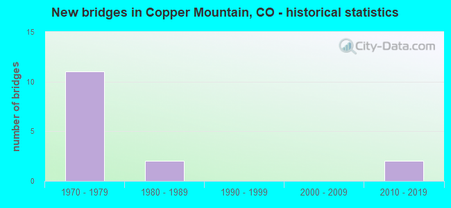
- New bridges - historical statistics
- 111970-1979
- 21980-1989
- 22010-2019


- Bridge Condition - Deck
- 22.2%Good
- 66.7%Satisfactory
- 11.1%Fair

- Bridge Condition - Superstructure
- 11.1%Good
- 11.1%Satisfactory
- 55.6%Fair
- 22.2%Poor

- Bridge Condition - Substructure
- 44.4%Good
- 44.4%Satisfactory
- 11.1%Fair

- Bridge Condition - Channel
- 75.0%Very good
- 25.0%Good

- Bridge Condition - Culverts
- 66.7%Good
- 33.3%Fair
Find on map >> Show street view
Structure Number: 21500000024256, Location: NO DATA ENTERED (Lat: 39.459819, Lng: -106.299322), Route carried "on" structure: Federal lands road 715.1, Year Built: 2011, Status: Open, Structure Length: 0.62m (2.03ft), Average Daily Traffic: 50 (year 0000), Average Future Daily Traffic: 75 (year 2042), Features Intersected: RESOLUTION CREEK
Minimum Vertical Clearance: 30+ m (98+ ft), Kilometerpoint: 0.032, Lanes on structure: 1, Owner: U.S. Forest Service, Approaching Roadway Width: 5.5m (18.0ft), Skew: 1 degrees, Material/Design: Steel, Design/Construction: Culvert, Number Of Spans In Main Unit: 1, Length of Maximum Span: 6.2m (20.3ft)
Condition: Channel: Good, Culverts: Good, Waterway Adequacy: Equal to present desirable criteria, Approach Roadway Alignment: Equal to present minimum criteria, Designated Inspection Frequency: Every 24 months, Inspection Date: August 2020
Find on map >> Show street view
Structure Number: 2150700002426, Location: NO DATA ENTERED (Lat: 39.420239, Lng: -106.285006), Route carried "on" structure: Federal lands road 726.1, Year Built: 2011, Status: Open, Structure Length: 0.64m (2.10ft), Average Daily Traffic: 50 (year 0000), Average Future Daily Traffic: 75 (year 2042), Features Intersected: NO DATA ENTERED
Minimum Vertical Clearance: 30+ m (98+ ft), Kilometerpoint: 0.032, Lanes on structure: 1, Owner: U.S. Forest Service, Approaching Roadway Width: 5.5m (18.0ft), Material/Design: Steel, Design/Construction: Culvert, Number Of Spans In Main Unit: 1, Length of Maximum Span: 6.4m (21.0ft)
Condition: Channel: Good, Culverts: Good, Waterway Adequacy: Equal to present desirable criteria, Approach Roadway Alignment: Equal to present desirable criteria, Designated Inspection Frequency: Every 24 months, Inspection Date: August 2020
Find on map >> Show street view
Structure Number: F-12-AA, Location: 2.1 MI E OF JCT SH91 (Lat: 39.537439, Lng: -106.142892), Route carried "on" structure: Interstate 70A, Year Built: 1977, Status: Open, Structure Length: 3.99m (13.09ft), Average Daily Traffic: 27,000 (year 2020), Truck Traffic: 11%, Average Future Daily Traffic: 34,020 (year 2040), Design Load: HS 20+Mod, Features Intersected: COUNTY ROAD, Facility Carried by Structure: I 70 ML
Minimum Vertical Clearance: 30+ m (98+ ft), Kilometerpoint: 319.690, Lanes on structure: 4, Lanes under structure: 2, Base Highway Network: Yes, Owner: State Highway Agency, Approaching Roadway Width: 23.2m (76.1ft), Skew: 20 degrees, Material/Design: Concrete continuous, Design/Construction: Tee Beam, Number Of Spans In Main Unit: 3, Length of Maximum Span: 15.0m (49.2ft), Curb-To-Curb Width: 32.9m (107.9ft), Out-to-Out Width: 33.8m (110.9ft)
Condition: Deck: Good, Superstructure: Good, Substructure: Good, Operating Rating: 70.3 metric tons, Method Used To Determine Operating Rating: Load Factor (LF), Inventory Rating: 42.1 metric tons, Method Used To Determine Inventory Rating: Load Factor (LF), Structural Evaluation: Better than present minimum criteria, Deck Geometry: Superior to present desirable criteria, Underclear: Equal to present minimum criteria, Approach Roadway Alignment: Equal to present desirable criteria, Designated Inspection Frequency: Every 24 months, Inspection Date: May 2021, Deck Structure Type: Concrete Cast-file-Place, Wearing Surface/Protective System: Wearing Surface: Bituminous, Membrane: Preformed Fabric
Find on map >> Show street view
Structure Number: F-12-AG, Location: AT COPPER MOUNTAIN (Lat: 39.506425, Lng: -106.143458), Route carried "on" structure: State highway 91A, Year Built: 1977, Status: Open, Structure Length: 9.39m (30.81ft), Average Daily Traffic: 7,700 (year 2020), Truck Traffic: 5%, Average Future Daily Traffic: 9,009 (year 2040), Design Load: HS 20, Features Intersected: I 70 ML, Facility Carried by Structure: SH 91 ML
Minimum Vertical Clearance: 30+ m (98+ ft), Kilometerpoint: 35.705, Lanes on structure: 3, Lanes under structure: 5, Base Highway Network: Yes, Owner: State Highway Agency, Approaching Roadway Width: 17.1m (56.1ft), Skew: 3 degrees, Material/Design: Prestressed concrete continuous, Design/Construction: Box Beam or Girders - Single/Spread, Number Of Spans In Main Unit: 2, Length of Maximum Span: 48.8m (160.1ft), Curb or Sidewalk Widths: Left: 1.8m (5.9ft), Right: 0.0m, Curb-To-Curb Width: 19.5m (64.0ft), Out-to-Out Width: 22.1m (72.5ft)
Condition: Deck: Satisfactory, Superstructure: Satisfactory, Substructure: Satisfactory, Operating Rating: 86.5 metric tons, Method Used To Determine Operating Rating: Load Factor (LF), Inventory Rating: 51.8 metric tons, Method Used To Determine Inventory Rating: Load Factor (LF), Structural Evaluation: Equal to present minimum criteria, Deck Geometry: Superior to present desirable criteria, Underclear: Equal to present minimum criteria, Approach Roadway Alignment: Equal to present desirable criteria, Designated Inspection Frequency: Every 24 months, Inspection Date: May 2021, Deck Structure Type: Concrete Cast-file-Place, Wearing Surface/Protective System: Wearing Surface: Bituminous, Membrane: Preformed Fabric
Find on map >> Show street view
Structure Number: F-12-AJ, Location: 0.1 MI E OF EAGLE SUMMIT (Lat: 39.529833, Lng: -106.215767), Route carried "on" structure: County highway , Year Built: 1975, Status: Open, Structure Length: 7.67m (25.16ft), Average Daily Traffic: 1,545 (year 2021), Truck Traffic: 11%, Average Future Daily Traffic: 1,885 (year 2041), Design Load: HS 20+Mod, Features Intersected: I 70 ML, Facility Carried by Structure: SHRINE PASS ROAD
Minimum Vertical Clearance: 30+ m (98+ ft), Kilometerpoint: 0.018, Lanes on structure: 2, Lanes under structure: 4, Owner: State Highway Agency, Approaching Roadway Width: 9.8m (32.2ft), Skew: 1 degrees, Material/Design: Steel continuous, Design/Construction: Box Beam or Girders - Single/Spread, Number Of Spans In Main Unit: 3, Length of Maximum Span: 55.8m (183.1ft), Curb or Sidewalk Widths: Left: 0.0m, Right: 1.8m (5.9ft), Curb-To-Curb Width: 9.8m (32.2ft), Out-to-Out Width: 12.8m (42.0ft)
Condition: Deck: Fair, Superstructure: Fair, Substructure: Fair, Operating Rating: 49.9 metric tons, Method Used To Determine Operating Rating: Load Factor (LF), Inventory Rating: 19.1 metric tons, Method Used To Determine Inventory Rating: Load Factor (LF), Structural Evaluation: Somewhat better than minimum adequacy, Deck Geometry: Somewhat better than minimum adequacy, Underclear: Superior to present desirable criteria, Approach Roadway Alignment: Better than present minimum criteria, Designated Inspection Frequency: Every 24 months, Critical Feature Inspection Frequency: Every 24 months, Other Special Inspection Frequency: Every 60 months, Inspection Date: June 2021, Critical Feature Inspection Date: August 2020, Other Special Inspection Date: June 2021, Deck Structure Type: Concrete Cast-file-Place, Wearing Surface/Protective System: Wearing Surface: Bituminous, Membrane: Preformed Fabric
Find on map >> Show street view
Structure Number: F-12-AK, Location: 1 MI E OF EAGLE SUMMIT CL (Lat: 39.519167, Lng: -106.213856), Route carried "on" structure: Interstate 70A, Year Built: 1977, Status: Open, Structure Length: 6.92m (22.70ft), Average Daily Traffic: 10,000 (year 2020), Truck Traffic: 14%, Average Future Daily Traffic: 12,100 (year 2040), Design Load: HS 20+Mod, Features Intersected: WILDER GULCH, Facility Carried by Structure: I 70 ML EBND
Minimum Vertical Clearance: 30+ m (98+ ft), Kilometerpoint: 308.790, Lanes on structure: 2, Base Highway Network: Yes, Owner: State Highway Agency, Approaching Roadway Width: 11.6m (38.1ft), Skew: 10 degrees, Material/Design: Steel continuous, Design/Construction: Box Beam or Girders - Single/Spread, Number Of Spans In Main Unit: 3, Length of Maximum Span: 48.8m (160.1ft), Curb-To-Curb Width: 11.6m (38.1ft), Out-to-Out Width: 12.8m (42.0ft)
Condition: Deck: Good, Superstructure: Fair, Substructure: Satisfactory, Channel: Very good, Operating Rating: 16.2 metric tons, Method Used To Determine Operating Rating: Load and Resistance Factor Rating (LRFR) rating reported by rating factor(RF) method using HL-93 loadings, Inventory Rating: 13.0 metric tons, Method Used To Determine Inventory Rating: Load and Resistance Factor Rating (LRFR) rating reported by rating factor(RF) method using HL-93 loadings, Structural Evaluation: High priority of replacement, Deck Geometry: Equal to present minimum criteria, Waterway Adequacy: Superior to present desirable criteria, Approach Roadway Alignment: Equal to present desirable criteria, Length Of Structure Improvement: 7.95m (26.08ft), Designated Inspection Frequency: Every 24 months, Critical Feature Inspection Frequency: Every 24 months, Other Special Inspection Frequency: Every 60 months, Inspection Date: August 2021, Critical Feature Inspection Date: August 2021, Other Special Inspection Date: June 2021, Bridge Improvement Cost: $1,384,000, Roadway Improvement Cost: $138,000, Total Project Cost: $2,076,000, Deck Structure Type: Concrete Cast-file-Place, Wearing Surface/Protective System: Wearing Surface: Bituminous, Membrane: Preformed Fabric
Find on map >> Show street view
Structure Number: F-12-AL, Location: 4 MI W OF JCT SH 91 (Lat: 39.516217, Lng: -106.206931), Route carried "on" structure: Interstate 70A, Year Built: 1979, Status: Open, Structure Length: 11.61m (38.09ft), Average Daily Traffic: 10,000 (year 2020), Truck Traffic: 14%, Average Future Daily Traffic: 12,100 (year 2040), Design Load: HS 20+Mod, Features Intersected: CORRAL CREEK, Facility Carried by Structure: I 70 ML WBND
Minimum Vertical Clearance: 30+ m (98+ ft), Kilometerpoint: 309.467, Lanes on structure: 2, Base Highway Network: Yes, Owner: State Highway Agency, Approaching Roadway Width: 11.6m (38.1ft), Skew: 19 degrees, Material/Design: Steel continuous, Design/Construction: Box Beam or Girders - Single/Spread, Number Of Spans In Main Unit: 3, Length of Maximum Span: 46.0m (150.9ft), Curb-To-Curb Width: 11.6m (38.1ft), Out-to-Out Width: 12.8m (42.0ft)
Condition: Deck: Satisfactory, Superstructure: Poor, Substructure: Good, Channel: Very good, Operating Rating: 52.6 metric tons, Method Used To Determine Operating Rating: Load Factor (LF), Inventory Rating: 30.9 metric tons, Method Used To Determine Inventory Rating: Load Factor (LF), Structural Evaluation: Meets minimum limits, Deck Geometry: Equal to present minimum criteria, Waterway Adequacy: Equal to present desirable criteria, Approach Roadway Alignment: Equal to present desirable criteria, Length Of Structure Improvement: 11.61m (38.09ft), Designated Inspection Frequency: Every 12 months, Critical Feature Inspection Frequency: Every 12 months, Inspection Date: August 2021, Critical Feature Inspection Date: August 2021, Bridge Improvement Cost: $1,498,000, Roadway Improvement Cost: $150,000, Total Project Cost: $2,247,000, Deck Structure Type: Concrete Cast-file-Place, Wearing Surface/Protective System: Wearing Surface: Bituminous, Membrane: Preformed Fabric
Find on map >> Show street view
Structure Number: F-12-AM, Location: I MI E OF SUMMIT EAGLE CL (Lat: 39.507325, Lng: -106.203375), Route carried "on" structure: Interstate 70A, Year Built: 1977, Status: Open, Structure Length: 8.31m (27.26ft), Average Daily Traffic: 10,000 (year 2020), Truck Traffic: 14%, Average Future Daily Traffic: 12,100 (year 2040), Design Load: HS 20+Mod, Features Intersected: SMITH GULCH, Facility Carried by Structure: I 70 ML EBND
Minimum Vertical Clearance: 30+ m (98+ ft), Kilometerpoint: 310.405, Lanes on structure: 2, Base Highway Network: Yes, Owner: State Highway Agency, Approaching Roadway Width: 11.6m (38.1ft), Skew: 10 degrees, Material/Design: Steel continuous, Design/Construction: Box Beam or Girders - Single/Spread, Number Of Spans In Main Unit: 2, Number Of Approach Spans: 2, Length of Maximum Span: 36.6m (120.1ft), Curb-To-Curb Width: 11.6m (38.1ft), Out-to-Out Width: 12.8m (42.0ft)
Condition: Deck: Satisfactory, Superstructure: Fair, Substructure: Good, Channel: Very good, Operating Rating: 25.9 metric tons, Method Used To Determine Operating Rating: Load and Resistance Factor Rating (LRFR) rating reported by rating factor(RF) method using HL-93 loadings, Inventory Rating: 19.4 metric tons, Method Used To Determine Inventory Rating: Load and Resistance Factor Rating (LRFR) rating reported by rating factor(RF) method using HL-93 loadings, Structural Evaluation: Meets minimum limits, Deck Geometry: Equal to present minimum criteria, Waterway Adequacy: Superior to present desirable criteria, Approach Roadway Alignment: Equal to present desirable criteria, Length Of Structure Improvement: 9.32m (30.58ft), Designated Inspection Frequency: Every 24 months, Critical Feature Inspection Frequency: Every 24 months, Inspection Date: August 2021, Critical Feature Inspection Date: August 2021, Bridge Improvement Cost: $1,905,000, Roadway Improvement Cost: $191,000, Total Project Cost: $2,805,000, Deck Structure Type: Concrete Cast-file-Place, Wearing Surface/Protective System: Wearing Surface: Bituminous, Membrane: Preformed Fabric
Find on map >> Show street view
Structure Number: F-12-AN, Location: 2.5 MI E OF EAGLE SUMMIT (Lat: 39.504775, Lng: -106.193472), Route carried "on" structure: Interstate 70A, Year Built: 1977, Status: Open, Structure Length: 11.64m (38.19ft), Average Daily Traffic: 10,000 (year 2020), Truck Traffic: 14%, Average Future Daily Traffic: 12,100 (year 2040), Design Load: HS 20+Mod, Features Intersected: STAFFORD GULCH, Facility Carried by Structure: I 70 ML EBND
Minimum Vertical Clearance: 30+ m (98+ ft), Kilometerpoint: 311.324, Lanes on structure: 2, Base Highway Network: Yes, Owner: State Highway Agency, Approaching Roadway Width: 11.6m (38.1ft), Skew: 10 degrees, Material/Design: Steel continuous, Design/Construction: Box Beam or Girders - Single/Spread, Number Of Spans In Main Unit: 3, Number Of Approach Spans: 2, Length of Maximum Span: 45.7m (149.9ft), Curb-To-Curb Width: 11.6m (38.1ft), Out-to-Out Width: 12.8m (42.0ft)
Condition: Deck: Satisfactory, Superstructure: Fair, Substructure: Good, Channel: Very good, Operating Rating: 39.6 metric tons, Method Used To Determine Operating Rating: Load Factor (LF), Inventory Rating: 23.0 metric tons, Method Used To Determine Inventory Rating: Load Factor (LF), Structural Evaluation: Somewhat better than minimum adequacy, Deck Geometry: Equal to present minimum criteria, Waterway Adequacy: Superior to present desirable criteria, Approach Roadway Alignment: Equal to present desirable criteria, Length Of Structure Improvement: 12.54m (41.14ft), Designated Inspection Frequency: Every 24 months, Critical Feature Inspection Frequency: Every 24 months, Inspection Date: September 2021, Critical Feature Inspection Date: September 2021, Bridge Improvement Cost: $2,336,000, Roadway Improvement Cost: $233,000, Total Project Cost: $3,504,000, Deck Structure Type: Concrete Cast-file-Place, Wearing Surface/Protective System: Wearing Surface: Bituminous, Membrane: Preformed Fabric
Find on map >> Show street view
Structure Number: F-12-AO, Location: 3.5 MI E/ VAIL PASS SUMIT (Lat: 39.502347, Lng: -106.177753), Route carried "on" structure: Interstate 70A, Year Built: 1977, Status: Open, Structure Length: 12.53m (41.11ft), Average Daily Traffic: 10,000 (year 2020), Truck Traffic: 14%, Average Future Daily Traffic: 12,100 (year 2040), Design Load: HS 20+Mod, Features Intersected: GULLER GULCH, Facility Carried by Structure: I 70 ML EBND
Minimum Vertical Clearance: 30+ m (98+ ft), Kilometerpoint: 312.720, Lanes on structure: 2, Base Highway Network: Yes, Owner: State Highway Agency, Approaching Roadway Width: 11.6m (38.1ft), Skew: 10 degrees, Material/Design: Steel continuous, Design/Construction: Box Beam or Girders - Single/Spread, Number Of Spans In Main Unit: 3, Number Of Approach Spans: 2, Length of Maximum Span: 48.8m (160.1ft), Curb-To-Curb Width: 11.6m (38.1ft), Out-to-Out Width: 12.8m (42.0ft)
Condition: Deck: Satisfactory, Superstructure: Poor, Substructure: Satisfactory, Channel: Very good, Operating Rating: 31.0 metric tons, Method Used To Determine Operating Rating: Load Factor (LF), Inventory Rating: 18.6 metric tons, Method Used To Determine Inventory Rating: Load Factor (LF), Structural Evaluation: Meets minimum limits, Deck Geometry: Equal to present minimum criteria, Waterway Adequacy: Superior to present desirable criteria, Approach Roadway Alignment: Better than present minimum criteria, Length Of Structure Improvement: 13.37m (43.86ft), Designated Inspection Frequency: Every 12 months, Critical Feature Inspection Frequency: Every 12 months, Inspection Date: August 2021, Critical Feature Inspection Date: August 2021, Bridge Improvement Cost: $2,506,000, Roadway Improvement Cost: $250,000, Total Project Cost: $3,759,000, Deck Structure Type: Concrete Cast-file-Place, Wearing Surface/Protective System: Wearing Surface: Bituminous, Membrane: Preformed Fabric
Find on map >> Show street view
Structure Number: F-12-AP, Location: @ COPPER MOUNTAIN (Lat: 39.501453, Lng: -106.170750), Route carried "on" structure: Interstate 70A, Year Built: 1977, Status: Open, Structure Length: 19.72m (64.70ft), Average Daily Traffic: 10,000 (year 2020), Truck Traffic: 14%, Average Future Daily Traffic: 12,100 (year 2040), Design Load: HS 20+Mod, Features Intersected: WEST TEN MILE CREEK, Facility Carried by Structure: I 70 ML EBND
Minimum Vertical Clearance: 30+ m (98+ ft), Kilometerpoint: 313.331, Lanes on structure: 2, Base Highway Network: Yes, Owner: State Highway Agency, Approaching Roadway Width: 11.6m (38.1ft), Skew: 10 degrees, Material/Design: Steel continuous, Design/Construction: Box Beam or Girders - Single/Spread, Number Of Spans In Main Unit: 3, Number Of Approach Spans: 2, Length of Maximum Span: 72.8m (238.8ft), Curb-To-Curb Width: 11.6m (38.1ft), Out-to-Out Width: 12.8m (42.0ft)
Condition: Deck: Satisfactory, Superstructure: Fair, Substructure: Satisfactory, Channel: Very good, Operating Rating: 41.2 metric tons, Method Used To Determine Operating Rating: Load Factor (LF), Inventory Rating: 24.7 metric tons, Method Used To Determine Inventory Rating: Load Factor (LF), Structural Evaluation: Somewhat better than minimum adequacy, Deck Geometry: Equal to present minimum criteria, Waterway Adequacy: Equal to present desirable criteria, Approach Roadway Alignment: Equal to present desirable criteria, Length Of Structure Improvement: 20.30m (66.60ft), Designated Inspection Frequency: Every 24 months, Critical Feature Inspection Frequency: Every 24 months, Inspection Date: August 2021, Critical Feature Inspection Date: August 2021, Bridge Improvement Cost: $3,951,000, Roadway Improvement Cost: $395,000, Total Project Cost: $5,926,000, Deck Structure Type: Concrete Cast-file-Place, Wearing Surface/Protective System: Wearing Surface: Bituminous, Membrane: Preformed Fabric
Find on map >> Show street view
Structure Number: G-12-R, Location: .1 MI N LAKE/SUMMIT CO LI (Lat: 39.380872, Lng: -106.190922), Route carried "on" structure: State highway 91A, Year Built: 1989, Status: Open, Structure Length: 1.44m (4.72ft), Average Daily Traffic: 5,100 (year 2020), Truck Traffic: 4%, Average Future Daily Traffic: 6,426 (year 2040), Design Load: HS 20+Mod, Features Intersected: CLIMAX MINE HAUL ROAD, Facility Carried by Structure: SH 91 ML
Minimum Vertical Clearance: 30+ m (98+ ft), Kilometerpoint: 19.666, Lanes on structure: 2, Lanes under structure: 2, Base Highway Network: Yes, Owner: State Highway Agency, Approaching Roadway Width: 12.2m (40.0ft), Skew: 1 degrees, Material/Design: Steel, Design/Construction: Culvert, Number Of Spans In Main Unit: 1, Length of Maximum Span: 14.4m (47.2ft), Out-to-Out Width: 35.4m (116.1ft)
Condition: Culverts: Fair, Operating Rating: 36.3 metric tons, Method Used To Determine Operating Rating: Load Factor (LF), Inventory Rating: 32.7 metric tons, Method Used To Determine Inventory Rating: Load Factor (LF), Structural Evaluation: Somewhat better than minimum adequacy, Underclear: Meets minimum limits, Approach Roadway Alignment: Equal to present desirable criteria, Designated Inspection Frequency: Every 24 months, Inspection Date: April 2021
Find on map >> Show street view
Structure Number: F-12-AG, Location: AT COPPER MOUNTAIN (Lat: 39.506425, Lng: -106.143458), Route carried "under" structure: Interstate 70A, Year Built: 1977, Structure Length: 0. m, Average Daily Traffic: 18,000 (year 2011), Truck Traffic: 12%, Features Intersected: I 70 ML, Facility Carried by Structure: SH 91 ML
Minimum Vertical Clearance: 5.69m (18.67ft), Kilometerpoint: 314.170, Lanes on structure: 3, Lanes under structure: 5, Material/Design: Prestressed concrete continuous, Design/Construction: Box Beam or Girders - Single/Spread, Length of Maximum Span: 48.8m (160.1ft)
Find on map >> Show street view
Structure Number: F-12-AJ, Location: 0.1 MI E OF EAGLE SUMMIT (Lat: 39.529833, Lng: -106.215767), Route carried "under" structure: Interstate 70A, Year Built: 1975, Structure Length: 0. m, Average Daily Traffic: 640 (year 2018), Truck Traffic: 12%, Features Intersected: I 70 ML, Facility Carried by Structure: SHRINE PASS ROAD
Minimum Vertical Clearance: 5.26m (17.26ft), Kilometerpoint: 0.018, Lanes on structure: 2, Lanes under structure: 4, Material/Design: Steel continuous, Design/Construction: Box Beam or Girders - Single/Spread, Length of Maximum Span: 55.8m (183.1ft)
Find on map >> Show street view
Structure Number: G-12-R, Location: .1 MI N LAKE/SUMMIT CO LI (Lat: 39.380872, Lng: -106.190922), Route carried "under" structure: State highway 91A, Year Built: 1989, Structure Length: 0. m, Average Daily Traffic: 3,200 (year 2011), Truck Traffic: 8%, Features Intersected: CLIMAX MINE HAUL ROAD, Facility Carried by Structure: SH 91 ML
Minimum Vertical Clearance: 30+ m (98+ ft), Kilometerpoint: 19.468, Lanes on structure: 2, Lanes under structure: 2, Material/Design: Steel, Design/Construction: Culvert, Length of Maximum Span: 14.4m (47.2ft)