Bridge Statistics for Converse, South Carolina (SC)
Condition, Traffic, Stress, Structural Evaluation, Project Costs
- National Bridge Inventory (NBI) Statistics
- 22Number of bridges
- 308ft / 93.8mTotal length
- $3,375,000Total costs
- 122,700Total average daily traffic
- 15,007Total average daily truck traffic
- National Bridge Inventory (NBI) Registered Bridges for Converse
- No street view available for this location
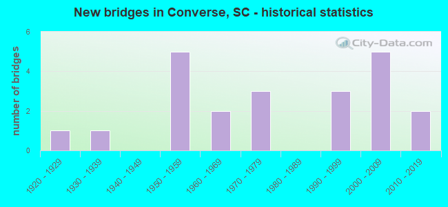
- New bridges - historical statistics
- 11920-1929
- 11930-1939
- 51950-1959
- 21960-1969
- 31970-1979
- 31990-1999
- 52000-2009
- 22010-2019

- Reconstructed bridges - Historical Statistics
- 21960-1969
- 11970-1979


- Bridge Condition - Deck
- 5.3%Excellent
- 36.8%Very good
- 15.8%Good
- 31.6%Satisfactory
- 5.3%Poor
- 5.3%Serious

- Bridge Condition - Superstructure
- 5.3%Excellent
- 36.8%Very good
- 10.5%Good
- 31.6%Satisfactory
- 5.3%Fair
- 10.5%Poor

- Bridge Condition - Substructure
- 5.3%Excellent
- 36.8%Very good
- 15.8%Good
- 15.8%Satisfactory
- 15.8%Fair
- 10.5%Poor

- Bridge Condition - Channel
- 16.7%Very good
- 72.2%Good
- 5.6%Satisfactory
- 5.6%Poor

- Bridge Condition - Culverts
- 50.0%Good
- 50.0%Satisfactory
Find on map >> Show street view
Structure Number: 169, Location: 2.0 MI W COWPENS (Lat: 35.012872, Lng: -81.837731), Route carried "on" structure: State highway 31, Year Built: 2002, Status: Open, Structure Length: 12.95m (42.49ft), Average Daily Traffic: 4,700 (year 2020), Truck Traffic: 5%, Average Future Daily Traffic: 6,815 (year 2040), Design Load: HS 25 or greater, Features Intersected: PACOLET RIVER
Minimum Vertical Clearance: 30+ m (98+ ft), Kilometerpoint: 4.046, Lanes on structure: 2, Owner: State Highway Agency, Approaching Roadway Width: 8.7m (28.5ft), Skew: 3 degrees, Material/Design: Prestressed concrete continuous, Design/Construction: Stringer/Multi-beam, Number Of Spans In Main Unit: 5, Length of Maximum Span: 32.0m (105.0ft), Curb-To-Curb Width: 10.4m (34.1ft), Out-to-Out Width: 11.4m (37.4ft)
Condition: Deck: Very good, Superstructure: Very good, Substructure: Very good, Channel: Good, Operating Rating: 56.7 metric tons, Method Used To Determine Operating Rating: Load and Resistance Factor Rating (LRFR) rating reported by rating factor(RF) method using HL-93 loadings, Inventory Rating: 43.7 metric tons, Method Used To Determine Inventory Rating: Load and Resistance Factor Rating (LRFR) rating reported by rating factor(RF) method using HL-93 loadings, Structural Evaluation: Equal to present desirable criteria, Deck Geometry: Somewhat better than minimum adequacy, Waterway Adequacy: Better than present minimum criteria, Approach Roadway Alignment: Equal to present minimum criteria, Length Of Structure Improvement: 12.95m (42.49ft), Designated Inspection Frequency: Every 24 months, Inspection Date: September 2021, Deck Structure Type: Concrete Cast-file-Place, Wearing Surface/Protective System: Wearing Surface: Monolithic Concrete
Find on map >> Show street view
Structure Number: 193, Location: 5.8MI NE LANCASTER (Lat: 34.775736, Lng: -80.699231), Route carried "on" structure: State highway 33, Year Built: 2002, Status: Open, Structure Length: 6.04m (19.82ft), Average Daily Traffic: 200 (year 2021), Average Future Daily Traffic: 292 (year 2041), Design Load: HS 20, Features Intersected: CAMP CREEK, Facility Carried by Structure: S-29-36
Minimum Vertical Clearance: 30+ m (98+ ft), Kilometerpoint: 1.880, Lanes on structure: 2, Owner: State Highway Agency, Approaching Roadway Width: 9.1m (29.9ft), Skew: 1 degrees, Material/Design: Prestressed concrete continuous, Design/Construction: Stringer/Multi-beam, Number Of Spans In Main Unit: 3, Length of Maximum Span: 20.1m (65.9ft), Curb-To-Curb Width: 10.2m (33.5ft), Out-to-Out Width: 11.1m (36.4ft)
Condition: Deck: Very good, Superstructure: Very good, Substructure: Very good, Channel: Good, Operating Rating: 39.2 metric tons, Method Used To Determine Operating Rating: Load and Resistance Factor Rating (LRFR) rating reported by rating factor(RF) method using HL-93 loadings, Inventory Rating: 30.5 metric tons, Method Used To Determine Inventory Rating: Load and Resistance Factor Rating (LRFR) rating reported by rating factor(RF) method using HL-93 loadings, Structural Evaluation: Better than present minimum criteria, Deck Geometry: Better than present minimum criteria, Waterway Adequacy: Equal to present desirable criteria, Approach Roadway Alignment: Equal to present desirable criteria, Length Of Structure Improvement: 6.04m (19.82ft), Designated Inspection Frequency: Every 24 months, Inspection Date: July 2021, Deck Structure Type: Concrete Cast-file-Place, Wearing Surface/Protective System: Wearing Surface: Monolithic Concrete
Find on map >> Show street view
Structure Number: 22, Location: 6.5 MI NE SPARTANBURG (Lat: 34.993672, Lng: -81.833433), Route carried "on" structure: US 29, Year Built: 1925, Year Reconstructed: 1972, Status: Open, Structure Length: 14.23m (46.69ft), Average Daily Traffic: 9,900 (year 2020), Truck Traffic: 4%, Average Future Daily Traffic: 19,701 (year 2040), Design Load: H 15, Features Intersected: PACOLET RIVER
Minimum Vertical Clearance: 30+ m (98+ ft), Kilometerpoint: 38.204, Lanes on structure: 4, Base Highway Network: Yes, Owner: State Highway Agency, Approaching Roadway Width: 19.5m (64.0ft), Skew: 20 degrees, Material/Design: Concrete, Design/Construction: Arch - Deck, Number Of Spans In Main Unit: 6, Length of Maximum Span: 53.3m (174.9ft), Curb or Sidewalk Widths: Left: 1.2m (3.9ft), Right: 1.2m (3.9ft), Curb-To-Curb Width: 19.5m (64.0ft), Out-to-Out Width: 22.6m (74.1ft)
Condition: Deck: Good, Superstructure: Good, Substructure: Good, Channel: Good, Operating Rating: 29.8 metric tons, Method Used To Determine Operating Rating: Load and Resistance Factor Rating (LRFR) rating reported by rating factor(RF) method using HL-93 loadings, Inventory Rating: 22.4 metric tons, Method Used To Determine Inventory Rating: Load and Resistance Factor Rating (LRFR) rating reported by rating factor(RF) method using HL-93 loadings, Structural Evaluation: Somewhat better than minimum adequacy, Deck Geometry: Better than present minimum criteria, Waterway Adequacy: Superior to present desirable criteria, Approach Roadway Alignment: Equal to present desirable criteria, Bridge Posting: Required (Relationship of Operating Rating to Maximum Legal Load: 0.1 - 9.9% below), Length Of Structure Improvement: 14.23m (46.69ft), Designated Inspection Frequency: Every 24 months, Inspection Date: January 2020, Deck Structure Type: Concrete Cast-file-Place, Wearing Surface/Protective System: Wearing Surface: Bituminous
Find on map >> Show street view
Structure Number: 98, Location: 5.5 MI NE SPARTANBURG (Lat: 34.989942, Lng: -81.851433), Route carried "on" structure: US 29, Year Built: 1939, Year Reconstructed: 1972, Status: Open, Structure Length: 6.77m (22.21ft), Average Daily Traffic: 9,900 (year 2020), Truck Traffic: 4%, Average Future Daily Traffic: 19,701 (year 2040), Design Load: H 20, Features Intersected: NS
Minimum Vertical Clearance: 30+ m (98+ ft), Kilometerpoint: 36.503, Lanes on structure: 5, Base Highway Network: Yes, Owner: State Highway Agency, Approaching Roadway Width: 19.5m (64.0ft), Skew: 5 degrees, Material/Design: Steel, Design/Construction: Stringer/Multi-beam, Number Of Spans In Main Unit: 3, Length of Maximum Span: 29.3m (96.1ft), Curb or Sidewalk Widths: Left: 1.5m (4.9ft), Right: 1.5m (4.9ft), Curb-To-Curb Width: 19.5m (64.0ft), Out-to-Out Width: 23.2m (76.1ft)
Condition: Deck: Serious, Superstructure: Fair, Substructure: Good, Operating Rating: 27.2 metric tons, Method Used To Determine Operating Rating: Load and Resistance Factor Rating (LRFR) rating reported by rating factor(RF) method using HL-93 loadings, Inventory Rating: 21.1 metric tons, Method Used To Determine Inventory Rating: Load and Resistance Factor Rating (LRFR) rating reported by rating factor(RF) method using HL-93 loadings, Structural Evaluation: Somewhat better than minimum adequacy, Deck Geometry: Meets minimum limits, Underclear: Equal to present minimum criteria, Approach Roadway Alignment: Equal to present desirable criteria, Length Of Structure Improvement: 6.77m (22.21ft), Designated Inspection Frequency: Every 24 months, Other Special Inspection Frequency: Every 24 months, Inspection Date: January 2020, Other Special Inspection Date: November 2021, Deck Structure Type: Concrete Cast-file-Place, Wearing Surface/Protective System: Wearing Surface: Bituminous
Find on map >> Show street view
Structure Number: 1717, Location: 3.9MI NW GREENVILLE (Lat: 34.893783, Lng: -82.441011), Route carried "on" structure: State highway 87, Year Built: 1950, Status: Open, Structure Length: 1.71m (5.61ft), Average Daily Traffic: 10,600 (year 2020), Truck Traffic: 2%, Average Future Daily Traffic: 16,218 (year 2040), Design Load: H 20, Features Intersected: REEDY RIVER
Minimum Vertical Clearance: 30+ m (98+ ft), Kilometerpoint: 4.059, Lanes on structure: 2, Owner: State Highway Agency, Approaching Roadway Width: 13.1m (43.0ft), Material/Design: Concrete, Design/Construction: Culvert, Number Of Spans In Main Unit: 5, Length of Maximum Span: 3.0m (9.8ft), Curb or Sidewalk Widths: Left: 1.4m (4.6ft), Right: 1.4m (4.6ft), Curb-To-Curb Width: 13.1m (43.0ft), Out-to-Out Width: 21.0m (68.9ft)
Condition: Channel: Good, Culverts: Good, Operating Rating: 31.4 metric tons, Method Used To Determine Operating Rating: Load and Resistance Factor Rating (LRFR) rating reported by rating factor(RF) method using HL-93 loadings, Inventory Rating: 24.3 metric tons, Method Used To Determine Inventory Rating: Load and Resistance Factor Rating (LRFR) rating reported by rating factor(RF) method using HL-93 loadings, Structural Evaluation: Equal to present minimum criteria, Deck Geometry: Somewhat better than minimum adequacy, Waterway Adequacy: Better than present minimum criteria, Approach Roadway Alignment: Equal to present desirable criteria, Length Of Structure Improvement: 2.43m (7.97ft), Designated Inspection Frequency: Every 24 months, Inspection Date: June 2021, Bridge Improvement Cost: $84,000, Roadway Improvement Cost: $21,000, Total Project Cost: $126,000 ( Estimate for 2021)
Find on map >> Show street view
Structure Number: 2129, Location: 1MI E OF OLAR (Lat: 33.170375, Lng: -81.171297), Route carried "on" structure: State highway 64, Year Built: 1955, Year Reconstructed: 1976, Status: Open, Structure Length: 0.64m (2.10ft), Average Daily Traffic: 700 (year 2020), Truck Traffic: 26%, Average Future Daily Traffic: 1,113 (year 2040), Design Load: H 20, Features Intersected: KIRKLAND CREEK
Minimum Vertical Clearance: 30+ m (98+ ft), Kilometerpoint: 5.449, Lanes on structure: 2, Base Highway Network: Yes, Owner: State Highway Agency, Approaching Roadway Width: 7.9m (25.9ft), Material/Design: Concrete, Design/Construction: Culvert, Number Of Spans In Main Unit: 2, Length of Maximum Span: 3.0m (9.8ft), Curb-To-Curb Width: 15.2m (49.9ft), Out-to-Out Width: 15.8m (51.8ft)
Condition: Channel: Very good, Culverts: Satisfactory, Operating Rating: 14.3 metric tons, Method Used To Determine Operating Rating: Load and Resistance Factor Rating (LRFR) rating reported by rating factor(RF) method using HL-93 loadings, Inventory Rating: 11.0 metric tons, Method Used To Determine Inventory Rating: Load and Resistance Factor Rating (LRFR) rating reported by rating factor(RF) method using HL-93 loadings, Structural Evaluation: High priority of corrective action, Deck Geometry: Superior to present desirable criteria, Waterway Adequacy: Equal to present minimum criteria, Approach Roadway Alignment: Equal to present desirable criteria, Length Of Structure Improvement: 1.25m (4.10ft), Designated Inspection Frequency: Every 24 months, Inspection Date: April 2020
Find on map >> Show street view
Structure Number: 2279, Location: 5.2 MI S YORK (Lat: 34.924531, Lng: -81.279822), Route carried "on" structure: State highway 170, Year Built: 1955, Status: Posted for load, Structure Length: 1.71m (5.61ft), Average Daily Traffic: 175 (year 2020), Truck Traffic: 4%, Average Future Daily Traffic: 256 (year 2040), Design Load: H 10, Features Intersected: MCCLURES BRANCH
Minimum Vertical Clearance: 30+ m (98+ ft), Kilometerpoint: 5.638, Lanes on structure: 2, Owner: State Highway Agency, Approaching Roadway Width: 7.6m (24.9ft), Material/Design: Concrete, Design/Construction: Slab, Number Of Spans In Main Unit: 4, Length of Maximum Span: 4.3m (14.1ft), Curb-To-Curb Width: 7.3m (24.0ft), Out-to-Out Width: 7.8m (25.6ft)
Condition: Deck: Poor, Superstructure: Poor, Substructure: Poor, Channel: Good, Operating Rating: 17.2 metric tons, Method Used To Determine Operating Rating: Load and Resistance Factor Rating (LRFR) rating reported by rating factor(RF) method using HL-93 loadings, Inventory Rating: 13.3 metric tons, Method Used To Determine Inventory Rating: Load and Resistance Factor Rating (LRFR) rating reported by rating factor(RF) method using HL-93 loadings, Structural Evaluation: Meets minimum limits, Deck Geometry: Somewhat better than minimum adequacy, Waterway Adequacy: Equal to present desirable criteria, Approach Roadway Alignment: Equal to present desirable criteria, Bridge Posting: Required (Relationship of Operating Rating to Maximum Legal Load: > 39.9% below), Length Of Structure Improvement: 2.43m (7.97ft), Designated Inspection Frequency: Every 12 months, Inspection Date: Febuary 2021, Bridge Improvement Cost: $214,000, Roadway Improvement Cost: $54,000, Total Project Cost: $321,000 ( Estimate for 2021), Deck Structure Type: Concrete Precast Panels, Wearing Surface/Protective System: Wearing Surface: Bituminous
Find on map >> Show street view
Structure Number: 2281, Location: 8.2 MI W ROCK HILL (Lat: 34.914958, Lng: -81.169994), Route carried "on" structure: State highway 347, Year Built: 2017, Status: Open, Structure Length: 2.74m (8.99ft), Average Daily Traffic: 1,000 (year 2020), Truck Traffic: 6%, Average Future Daily Traffic: 2,110 (year 2040), Design Load: HL 93, Features Intersected: STONY FORK CREEK
Minimum Vertical Clearance: 30+ m (98+ ft), Kilometerpoint: 5.988, Lanes on structure: 2, Owner: State Highway Agency, Approaching Roadway Width: 10.7m (35.1ft), Skew: 3 degrees, Material/Design: Prestressed concrete, Design/Construction: Stringer/Multi-beam, Number Of Spans In Main Unit: 1, Length of Maximum Span: 27.4m (89.9ft), Curb-To-Curb Width: 12.1m (39.7ft), Out-to-Out Width: 13.0m (42.7ft)
Condition: Deck: Excellent, Superstructure: Excellent, Substructure: Excellent, Channel: Good, Operating Rating: 61.6 metric tons, Method Used To Determine Operating Rating: Load and Resistance Factor Rating (LRFR) rating reported by rating factor(RF) method using HL-93 loadings, Inventory Rating: 31.4 metric tons, Method Used To Determine Inventory Rating: Load and Resistance Factor Rating (LRFR) rating reported by rating factor(RF) method using HL-93 loadings, Structural Evaluation: Better than present minimum criteria, Deck Geometry: Better than present minimum criteria, Waterway Adequacy: Equal to present desirable criteria, Approach Roadway Alignment: Better than present minimum criteria, Bridge Posting: Required (Relationship of Operating Rating to Maximum Legal Load: > 39.9% below), Length Of Structure Improvement: 3.57m (11.71ft), Designated Inspection Frequency: Every 24 months, Inspection Date: March 2020, Bridge Improvement Cost: $360,000, Roadway Improvement Cost: $90,000, Total Project Cost: $540,000 ( Estimate for 2021), Deck Structure Type: Concrete Precast Panels, Wearing Surface/Protective System: Wearing Surface: Monolithic Concrete
Find on map >> Show street view
Structure Number: 2282, Location: 7.9 MI W ROCK HILL (Lat: 34.932672, Lng: -81.165217), Route carried "on" structure: State highway 347, Year Built: 2002, Status: Open, Structure Length: 5.03m (16.50ft), Average Daily Traffic: 1,000 (year 2020), Truck Traffic: 6%, Average Future Daily Traffic: 2,110 (year 2040), Design Load: HS 25 or greater, Features Intersected: FISHING CREEK
Minimum Vertical Clearance: 30+ m (98+ ft), Kilometerpoint: 3.933, Lanes on structure: 2, Owner: State Highway Agency, Approaching Roadway Width: 9.8m (32.2ft), Material/Design: Prestressed concrete continuous, Design/Construction: Stringer/Multi-beam, Number Of Spans In Main Unit: 1, Number Of Approach Spans: 2, Length of Maximum Span: 22.9m (75.1ft), Curb-To-Curb Width: 10.1m (33.1ft), Out-to-Out Width: 11.0m (36.1ft)
Condition: Deck: Very good, Superstructure: Very good, Substructure: Very good, Channel: Good, Operating Rating: 33.7 metric tons, Method Used To Determine Operating Rating: Load and Resistance Factor Rating (LRFR) rating reported by rating factor(RF) method using HL-93 loadings, Inventory Rating: 26.2 metric tons, Method Used To Determine Inventory Rating: Load and Resistance Factor Rating (LRFR) rating reported by rating factor(RF) method using HL-93 loadings, Structural Evaluation: Equal to present minimum criteria, Deck Geometry: Equal to present minimum criteria, Waterway Adequacy: Equal to present desirable criteria, Approach Roadway Alignment: Equal to present desirable criteria, Length Of Structure Improvement: 5.03m (16.50ft), Designated Inspection Frequency: Every 24 months, Inspection Date: Febuary 2021, Deck Structure Type: Concrete Cast-file-Place, Wearing Surface/Protective System: Wearing Surface: Monolithic Concrete
Find on map >> Show street view
Structure Number: 2283, Location: 6.3 MI SW ROCK HILL (Lat: 34.840497, Lng: -81.066492), Route carried "on" structure: State highway 739, Year Built: 2004, Status: Open, Structure Length: 3.66m (12.01ft), Average Daily Traffic: 550 (year 2020), Truck Traffic: 6%, Average Future Daily Traffic: 1,161 (year 2040), Design Load: HS 20, Features Intersected: STONY FORK CREEK
Minimum Vertical Clearance: 30+ m (98+ ft), Kilometerpoint: 2.511, Lanes on structure: 2, Owner: State Highway Agency, Approaching Roadway Width: 9.4m (30.8ft), Material/Design: Prestressed concrete, Design/Construction: Box Beam or Girders - Multiple, Number Of Spans In Main Unit: 1, Number Of Approach Spans: 2, Length of Maximum Span: 18.3m (60.0ft), Curb-To-Curb Width: 10.1m (33.1ft), Out-to-Out Width: 11.0m (36.1ft)
Condition: Deck: Very good, Superstructure: Very good, Substructure: Very good, Channel: Good, Operating Rating: 53.1 metric tons, Method Used To Determine Operating Rating: Load and Resistance Factor Rating (LRFR) rating reported by rating factor(RF) method using HL-93 loadings, Inventory Rating: 33.0 metric tons, Method Used To Determine Inventory Rating: Load and Resistance Factor Rating (LRFR) rating reported by rating factor(RF) method using HL-93 loadings, Structural Evaluation: Equal to present desirable criteria, Deck Geometry: Equal to present minimum criteria, Waterway Adequacy: Equal to present minimum criteria, Approach Roadway Alignment: Equal to present desirable criteria, Length Of Structure Improvement: 3.66m (12.01ft), Designated Inspection Frequency: Every 24 months, Inspection Date: March 2021, Deck Structure Type: Concrete Cast-file-Place, Wearing Surface/Protective System: Wearing Surface: Bituminous
Find on map >> Show street view
Structure Number: 2892, Location: 9.0 MI SE OF ANDERSON (Lat: 34.401425, Lng: -82.542478), Route carried "on" structure: State highway 185, Year Built: 1959, Status: Open, Structure Length: 3.66m (12.01ft), Average Daily Traffic: 2,000 (year 2021), Truck Traffic: 8%, Average Future Daily Traffic: 2,920 (year 2041), Design Load: HS 15, Features Intersected: HEN COOP CREEK
Minimum Vertical Clearance: 30+ m (98+ ft), Kilometerpoint: 7.231, Lanes on structure: 2, Owner: State Highway Agency, Approaching Roadway Width: 7.9m (25.9ft), Material/Design: Concrete, Design/Construction: Tee Beam, Number Of Spans In Main Unit: 4, Length of Maximum Span: 9.1m (29.9ft), Curb-To-Curb Width: 8.5m (27.9ft), Out-to-Out Width: 9.9m (32.5ft)
Condition: Deck: Satisfactory, Superstructure: Satisfactory, Substructure: Fair, Channel: Very good, Operating Rating: 42.8 metric tons, Method Used To Determine Operating Rating: Load and Resistance Factor Rating (LRFR) rating reported by rating factor(RF) method using HL-93 loadings, Inventory Rating: 27.2 metric tons, Method Used To Determine Inventory Rating: Load and Resistance Factor Rating (LRFR) rating reported by rating factor(RF) method using HL-93 loadings, Structural Evaluation: Somewhat better than minimum adequacy, Deck Geometry: Somewhat better than minimum adequacy, Waterway Adequacy: Equal to present desirable criteria, Approach Roadway Alignment: Equal to present minimum criteria, Length Of Structure Improvement: 3.66m (12.01ft), Designated Inspection Frequency: Every 24 months, Inspection Date: December 2021, Deck Structure Type: Concrete Cast-file-Place, Wearing Surface/Protective System: Wearing Surface: Bituminous
Find on map >> Show street view
Structure Number: 3, Location: 5 MI SE OF BETHUNE (Lat: 34.367300, Lng: -80.289747), Route carried "on" structure: State highway 15, Year Built: 1959, Status: Posted for load, Structure Length: 10.06m (33.01ft), Average Daily Traffic: 1,350 (year 2020), Truck Traffic: 9%, Average Future Daily Traffic: 1,971 (year 2040), Design Load: HS 15, Features Intersected: LYNCHES RIVER
Minimum Vertical Clearance: 30+ m (98+ ft), Kilometerpoint: 0.000, Lanes on structure: 2, Owner: State Highway Agency, Approaching Roadway Width: 8.5m (27.9ft), Material/Design: Concrete, Design/Construction: Tee Beam, Number Of Spans In Main Unit: 11, Length of Maximum Span: 9.1m (29.9ft), Curb or Sidewalk Widths: Left: 0.5m (1.6ft), Right: 0.5m (1.6ft), Curb-To-Curb Width: 8.5m (27.9ft), Out-to-Out Width: 9.4m (30.8ft)
Condition: Deck: Satisfactory, Superstructure: Poor, Substructure: Satisfactory, Channel: Satisfactory, Operating Rating: 30.1 metric tons, Method Used To Determine Operating Rating: Load and Resistance Factor Rating (LRFR) rating reported by rating factor(RF) method using HL-93 loadings, Inventory Rating: 22.7 metric tons, Method Used To Determine Inventory Rating: Load and Resistance Factor Rating (LRFR) rating reported by rating factor(RF) method using HL-93 loadings, Structural Evaluation: Meets minimum limits, Deck Geometry: Somewhat better than minimum adequacy, Waterway Adequacy: Better than present minimum criteria, Approach Roadway Alignment: Equal to present desirable criteria, Bridge Posting: Required (Relationship of Operating Rating to Maximum Legal Load: 20.0 - 29.9% below), Length Of Structure Improvement: 11.11m (36.45ft), Designated Inspection Frequency: Every 12 months, Inspection Date: April 2021, Bridge Improvement Cost: $1,121,000, Roadway Improvement Cost: $280,000, Total Project Cost: $1,682,000 ( Estimate for 2021), Deck Structure Type: Concrete Cast-file-Place, Wearing Surface/Protective System: Wearing Surface: Monolithic Concrete
Find on map >> Show street view
Structure Number: 5121, Location: 4MI W MARION (Lat: 34.155708, Lng: -79.455061), Route carried "on" structure: State highway 64, Year Built: 1967, Status: Open, Structure Length: 1.37m (4.49ft), Average Daily Traffic: 225 (year 2020), Truck Traffic: 9%, Average Future Daily Traffic: 329 (year 2040), Design Load: H 10, Features Intersected: PITCH POT SWAMP
Minimum Vertical Clearance: 30+ m (98+ ft), Kilometerpoint: 10.231, Lanes on structure: 2, Owner: State Highway Agency, Approaching Roadway Width: 6.1m (20.0ft), Material/Design: Concrete, Design/Construction: Slab, Number Of Spans In Main Unit: 3, Length of Maximum Span: 4.6m (15.1ft), Curb-To-Curb Width: 7.9m (25.9ft), Out-to-Out Width: 8.7m (28.5ft)
Condition: Deck: Satisfactory, Superstructure: Satisfactory, Substructure: Satisfactory, Channel: Good, Operating Rating: 19.1 metric tons, Method Used To Determine Operating Rating: Load and Resistance Factor Rating (LRFR) rating reported by rating factor(RF) method using HL-93 loadings, Inventory Rating: 14.6 metric tons, Method Used To Determine Inventory Rating: Load and Resistance Factor Rating (LRFR) rating reported by rating factor(RF) method using HL-93 loadings, Structural Evaluation: Meets minimum limits, Deck Geometry: Somewhat better than minimum adequacy, Waterway Adequacy: Equal to present desirable criteria, Approach Roadway Alignment: Equal to present desirable criteria, Bridge Posting: Required (Relationship of Operating Rating to Maximum Legal Load: 30.0 - 39.9% below), Length Of Structure Improvement: 1.37m (4.49ft), Designated Inspection Frequency: Every 24 months, Inspection Date: May 2021, Deck Structure Type: Concrete Precast Panels, Wearing Surface/Protective System: Wearing Surface: Bituminous
Find on map >> Show street view
Structure Number: 5122, Location: BRITTONS NECK (Lat: 33.924586, Lng: -79.357225), Route carried "on" structure: State highway 307, Year Built: 1967, Status: Open, Structure Length: 0.91m (2.99ft), Average Daily Traffic: 175 (year 2021), Truck Traffic: 5%, Average Future Daily Traffic: 224 (year 2041), Design Load: H 10, Features Intersected: TRIB TO MAPLE SWAMP CR
Minimum Vertical Clearance: 30+ m (98+ ft), Kilometerpoint: 0.496, Lanes on structure: 2, Owner: State Highway Agency, Approaching Roadway Width: 6.1m (20.0ft), Material/Design: Concrete, Design/Construction: Slab, Number Of Spans In Main Unit: 2, Length of Maximum Span: 4.6m (15.1ft), Curb-To-Curb Width: 7.9m (25.9ft), Out-to-Out Width: 8.5m (27.9ft)
Condition: Deck: Satisfactory, Superstructure: Satisfactory, Substructure: Satisfactory, Channel: Good, Operating Rating: 21.1 metric tons, Method Used To Determine Operating Rating: Load and Resistance Factor Rating (LRFR) rating reported by rating factor(RF) method using HL-93 loadings, Inventory Rating: 16.2 metric tons, Method Used To Determine Inventory Rating: Load and Resistance Factor Rating (LRFR) rating reported by rating factor(RF) method using HL-93 loadings, Structural Evaluation: Somewhat better than minimum adequacy, Deck Geometry: Somewhat better than minimum adequacy, Waterway Adequacy: Equal to present minimum criteria, Approach Roadway Alignment: Equal to present minimum criteria, Bridge Posting: Required (Relationship of Operating Rating to Maximum Legal Load: 20.0 - 29.9% below), Length Of Structure Improvement: 0.91m (2.99ft), Designated Inspection Frequency: Every 24 months, Inspection Date: May 2021, Deck Structure Type: Concrete Precast Panels, Wearing Surface/Protective System: Wearing Surface: Bituminous
Find on map >> Show street view
Structure Number: 5123, Location: 2MI E MULLINS (Lat: 34.208183, Lng: -79.194914), Route carried "on" structure: State highway 472, Year Built: 2012, Status: Open, Structure Length: 1.52m (4.99ft), Average Daily Traffic: 125 (year 2020), Truck Traffic: 5%, Average Future Daily Traffic: 160 (year 2040), Design Load: HS 20, Features Intersected: BRIAR CREEK
Minimum Vertical Clearance: 30+ m (98+ ft), Kilometerpoint: 0.798, Lanes on structure: 2, Owner: State Highway Agency, Approaching Roadway Width: 6.7m (22.0ft), Material/Design: Prestressed concrete, Design/Construction: Slab, Number Of Spans In Main Unit: 1, Length of Maximum Span: 15.2m (49.9ft), Curb-To-Curb Width: 10.1m (33.1ft), Out-to-Out Width: 11.0m (36.1ft)
Condition: Deck: Very good, Superstructure: Very good, Substructure: Very good, Channel: Good, Operating Rating: 57.3 metric tons, Method Used To Determine Operating Rating: Load and Resistance Factor Rating (LRFR) rating reported by rating factor(RF) method using HL-93 loadings, Inventory Rating: 44.1 metric tons, Method Used To Determine Inventory Rating: Load and Resistance Factor Rating (LRFR) rating reported by rating factor(RF) method using HL-93 loadings, Structural Evaluation: Equal to present desirable criteria, Deck Geometry: Better than present minimum criteria, Waterway Adequacy: Equal to present desirable criteria, Approach Roadway Alignment: Equal to present desirable criteria, Length Of Structure Improvement: 1.52m (4.99ft), Designated Inspection Frequency: Every 24 months, Inspection Date: June 2021, Deck Structure Type: Concrete Precast Panels, Wearing Surface/Protective System: Wearing Surface: Bituminous
Find on map >> Show street view
Structure Number: 586, Location: 3.5 MI SW COWPENS (Lat: 34.981286, Lng: -81.846911), Route carried "on" structure: County highway 8217, Year Built: 2003, Status: Open, Structure Length: 0.76m (2.49ft), Average Daily Traffic: 75 (year 2020), Average Future Daily Traffic: 96 (year 2040), Design Load: HS 20, Features Intersected: TRIB-PACOLET RIVER
Minimum Vertical Clearance: 30+ m (98+ ft), Kilometerpoint: 0.171, Lanes on structure: 2, Owner: County Highway Agency, Approaching Roadway Width: 5.8m (19.0ft), Material/Design: Prestressed concrete, Design/Construction: Channel Beam, Number Of Spans In Main Unit: 1, Length of Maximum Span: 7.6m (24.9ft), Curb-To-Curb Width: 8.3m (27.2ft), Out-to-Out Width: 8.4m (27.6ft)
Condition: Deck: Very good, Superstructure: Very good, Substructure: Very good, Channel: Good, Operating Rating: 36.6 metric tons, Method Used To Determine Operating Rating: Load and Resistance Factor Rating (LRFR) rating reported by rating factor(RF) method using HL-93 loadings, Inventory Rating: 28.2 metric tons, Method Used To Determine Inventory Rating: Load and Resistance Factor Rating (LRFR) rating reported by rating factor(RF) method using HL-93 loadings, Structural Evaluation: Better than present minimum criteria, Deck Geometry: Equal to present minimum criteria, Waterway Adequacy: Better than present minimum criteria, Approach Roadway Alignment: Equal to present minimum criteria, Length Of Structure Improvement: 0.76m (2.49ft), Designated Inspection Frequency: Every 24 months, Inspection Date: November 2021, Deck Structure Type: Concrete Precast Panels, Wearing Surface/Protective System: Wearing Surface: Monolithic Concrete
Find on map >> Show street view
Structure Number: 6183, Location: 7 MI SE OF COLUMBIA (Lat: 33.919744, Lng: -80.957817), Route carried "on" structure: State highway 960, Year Built: 1972, Status: Open, Structure Length: 1.83m (6.00ft), Average Daily Traffic: 75 (year 2020), Average Future Daily Traffic: 96 (year 2040), Design Load: H 15, Features Intersected: BLACK LAKE
Minimum Vertical Clearance: 30+ m (98+ ft), Kilometerpoint: 5.132, Lanes on structure: 2, Owner: State Highway Agency, Approaching Roadway Width: 7.3m (24.0ft), Material/Design: Concrete, Design/Construction: Slab, Number Of Spans In Main Unit: 4, Length of Maximum Span: 4.6m (15.1ft), Curb-To-Curb Width: 7.4m (24.3ft), Out-to-Out Width: 8.4m (27.6ft)
Condition: Deck: Good, Superstructure: Good, Substructure: Fair, Channel: Very good, Operating Rating: 29.2 metric tons, Method Used To Determine Operating Rating: Load and Resistance Factor Rating (LRFR) rating reported by rating factor(RF) method using HL-93 loadings, Inventory Rating: 22.7 metric tons, Method Used To Determine Inventory Rating: Load and Resistance Factor Rating (LRFR) rating reported by rating factor(RF) method using HL-93 loadings, Structural Evaluation: Somewhat better than minimum adequacy, Deck Geometry: Equal to present minimum criteria, Waterway Adequacy: Better than present minimum criteria, Approach Roadway Alignment: Equal to present desirable criteria, Length Of Structure Improvement: 1.83m (6.00ft), Designated Inspection Frequency: Every 24 months, Inspection Date: March 2021, Deck Structure Type: Concrete Precast Panels, Wearing Surface/Protective System: Wearing Surface: Monolithic Concrete
Find on map >> Show street view
Structure Number: 6938, Location: 3.0 MI SW COWPENS (Lat: 34.979992, Lng: -81.838608), Route carried "on" structure: State highway 824, Year Built: 1976, Status: Open, Structure Length: 2.74m (8.99ft), Average Daily Traffic: 1,550 (year 2020), Truck Traffic: 7%, Average Future Daily Traffic: 2,325 (year 2040), Design Load: H 15, Features Intersected: CINDER BRANCH
Minimum Vertical Clearance: 30+ m (98+ ft), Kilometerpoint: 0.626, Lanes on structure: 2, Owner: State Highway Agency, Approaching Roadway Width: 8.2m (26.9ft), Material/Design: Prestressed concrete, Design/Construction: Channel Beam, Number Of Spans In Main Unit: 3, Length of Maximum Span: 9.1m (29.9ft), Curb-To-Curb Width: 12.8m (42.0ft), Out-to-Out Width: 13.3m (43.6ft)
Condition: Deck: Satisfactory, Superstructure: Satisfactory, Substructure: Fair, Channel: Good, Operating Rating: 5.2 metric tons, Method Used To Determine Operating Rating: Load and Resistance Factor Rating (LRFR) rating reported by rating factor(RF) method using HL-93 loadings, Inventory Rating: 1.3 metric tons, Method Used To Determine Inventory Rating: Load and Resistance Factor Rating (LRFR) rating reported by rating factor(RF) method using HL-93 loadings, Structural Evaluation: High priority of replacement, Deck Geometry: Better than present minimum criteria, Waterway Adequacy: Equal to present desirable criteria, Approach Roadway Alignment: Equal to present desirable criteria, Bridge Posting: Required (Relationship of Operating Rating to Maximum Legal Load: > 39.9% below), Length Of Structure Improvement: 3.57m (11.71ft), Designated Inspection Frequency: Every 24 months, Inspection Date: September 2021, Bridge Improvement Cost: $360,000, Roadway Improvement Cost: $90,000, Total Project Cost: $540,000 ( Estimate for 2021), Deck Structure Type: Concrete Cast-file-Place, Wearing Surface/Protective System: Wearing Surface: Bituminous
Find on map >> Show street view
Structure Number: 7172, Location: 6.0 MI NE SPARTANBURG (Lat: 34.999800, Lng: -81.840522), Route carried "on" structure: State highway 57, Year Built: 1978, Status: Open, Structure Length: 3.20m (10.50ft), Average Daily Traffic: 400 (year 2020), Truck Traffic: 4%, Average Future Daily Traffic: 512 (year 2040), Design Load: H 15, Features Intersected: PETERS CREEK
Minimum Vertical Clearance: 30+ m (98+ ft), Kilometerpoint: 7.923, Lanes on structure: 2, Owner: State Highway Agency, Approaching Roadway Width: 7.3m (24.0ft), Material/Design: Concrete, Design/Construction: Slab, Number Of Spans In Main Unit: 7, Length of Maximum Span: 4.6m (15.1ft), Curb-To-Curb Width: 9.6m (31.5ft), Out-to-Out Width: 10.1m (33.1ft)
Condition: Deck: Satisfactory, Superstructure: Satisfactory, Substructure: Poor, Channel: Poor, Operating Rating: 26.9 metric tons, Method Used To Determine Operating Rating: Load and Resistance Factor Rating (LRFR) rating reported by rating factor(RF) method using HL-93 loadings, Inventory Rating: 20.7 metric tons, Method Used To Determine Inventory Rating: Load and Resistance Factor Rating (LRFR) rating reported by rating factor(RF) method using HL-93 loadings, Structural Evaluation: Meets minimum limits, Deck Geometry: Equal to present minimum criteria, Waterway Adequacy: Better than present minimum criteria, Approach Roadway Alignment: Equal to present minimum criteria, Length Of Structure Improvement: 4.06m (13.32ft), Designated Inspection Frequency: Every 12 months, Inspection Date: September 2021, Bridge Improvement Cost: $151,000, Roadway Improvement Cost: $8,000, Total Project Cost: $166,000 ( Estimate for 2021), Deck Structure Type: Concrete Cast-file-Place, Wearing Surface/Protective System: Wearing Surface: Bituminous
Find on map >> Show street view
Structure Number: 8787, Location: 4.0 MI W COWPENS (Lat: 35.026619, Lng: -81.876117), Route carried "on" structure: State highway 57, Year Built: 1994, Status: Open, Structure Length: 7.77m (25.49ft), Average Daily Traffic: 3,100 (year 2020), Truck Traffic: 6%, Average Future Daily Traffic: 7,099 (year 2040), Design Load: HS 20, Features Intersected: I-85
Minimum Vertical Clearance: 5.79m (19.00ft), Kilometerpoint: 2.874, Lanes on structure: 5, Lanes under structure: 7, Owner: State Highway Agency, Approaching Roadway Width: 24.1m (79.1ft), Material/Design: Steel continuous, Design/Construction: Stringer/Multi-beam, Number Of Spans In Main Unit: 4, Length of Maximum Span: 27.7m (90.9ft), Curb or Sidewalk Widths: Left: 1.5m (4.9ft), Right: 1.5m (4.9ft), Curb-To-Curb Width: 24.1m (79.1ft), Out-to-Out Width: 27.7m (90.9ft)
Condition: Deck: Good, Superstructure: Satisfactory, Substructure: Good, Operating Rating: 38.2 metric tons, Method Used To Determine Operating Rating: Load and Resistance Factor Rating (LRFR) rating reported by rating factor(RF) method using HL-93 loadings, Inventory Rating: 29.5 metric tons, Method Used To Determine Inventory Rating: Load and Resistance Factor Rating (LRFR) rating reported by rating factor(RF) method using HL-93 loadings, Structural Evaluation: Equal to present minimum criteria, Deck Geometry: Superior to present desirable criteria, Underclear: Equal to present minimum criteria, Approach Roadway Alignment: Equal to present desirable criteria, Length Of Structure Improvement: 7.83m (25.69ft), Designated Inspection Frequency: Every 24 months, Inspection Date: September 2021, Deck Structure Type: Concrete Cast-file-Place
Find on map >> Show street view
Structure Number: 8788, Location: 4.0 MI W COWPENS (Lat: 35.019181, Lng: -81.872969), Route carried "on" structure: State highway 57, Year Built: 1994, Status: Open, Structure Length: 4.45m (14.60ft), Average Daily Traffic: 14,300 (year 2020), Truck Traffic: 9%, Average Future Daily Traffic: 32,747 (year 2040), Design Load: HS 20, Features Intersected: CSXT
Minimum Vertical Clearance: 30+ m (98+ ft), Kilometerpoint: 3.800, Lanes on structure: 4, Owner: State Highway Agency, Approaching Roadway Width: 17.4m (57.1ft), Skew: 3 degrees, Material/Design: Prestressed concrete, Design/Construction: Stringer/Multi-beam, Number Of Spans In Main Unit: 3, Length of Maximum Span: 14.9m (48.9ft), Curb or Sidewalk Widths: Left: 1.5m (4.9ft), Right: 1.5m (4.9ft), Curb-To-Curb Width: 20.4m (66.9ft), Out-to-Out Width: 24.0m (78.7ft)
Condition: Deck: Very good, Superstructure: Very good, Substructure: Very good, Operating Rating: 47.0 metric tons, Method Used To Determine Operating Rating: Load and Resistance Factor Rating (LRFR) rating reported by rating factor(RF) method using HL-93 loadings, Inventory Rating: 34.7 metric tons, Method Used To Determine Inventory Rating: Load and Resistance Factor Rating (LRFR) rating reported by rating factor(RF) method using HL-93 loadings, Structural Evaluation: Equal to present desirable criteria, Deck Geometry: Superior to present desirable criteria, Underclear: Equal to present minimum criteria, Approach Roadway Alignment: Equal to present desirable criteria, Length Of Structure Improvement: 4.45m (14.60ft), Designated Inspection Frequency: Every 24 months, Inspection Date: September 2021, Deck Structure Type: Concrete Cast-file-Place, Wearing Surface/Protective System: Wearing Surface: Monolithic Concrete
Find on map >> Show street view
Structure Number: 8787, Location: 4.0 MI W COWPENS (Lat: 35.026619, Lng: -81.876117), Route carried "under" structure: Interstate 85, Year Built: 1994, Structure Length: 0. m, Average Daily Traffic: 60,600 (year 2020), Truck Traffic: 19%, Features Intersected: I-85, Facility Carried by Structure: S-42-57
Minimum Vertical Clearance: 5.79m (19.00ft), Kilometerpoint: 127.541, Lanes on structure: 5, Lanes under structure: 7, Material/Design: Steel continuous, Design/Construction: Stringer/Multi-beam, Length of Maximum Span: 27.7m (90.9ft)