Bridge Statistics for Constantine, Michigan (MI)
Condition, Traffic, Stress, Structural Evaluation, Project Costs
- National Bridge Inventory (NBI) Statistics
- 12Number of bridges
- 236ft / 72.5mTotal length
- 97,525Total average daily traffic
- 6,497Total average daily truck traffic
- 105,587Total future (year 2015) average daily traffic
- National Bridge Inventory (NBI) Registered Bridges for Constantine
- No street view available for this location
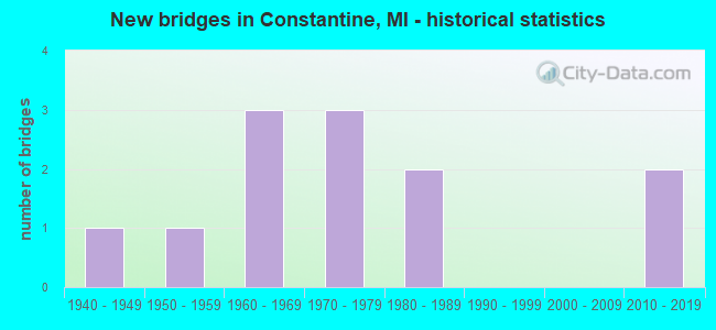
- New bridges - historical statistics
- 11940-1949
- 11950-1959
- 31960-1969
- 31970-1979
- 21980-1989
- 22010-2019


- Bridge Condition - Deck
- 16.7%Very good
- 16.7%Good
- 41.7%Satisfactory
- 8.3%Fair
- 16.7%Poor

- Bridge Condition - Superstructure
- 8.3%Very good
- 33.3%Good
- 41.7%Satisfactory
- 8.3%Fair
- 8.3%Poor

- Bridge Condition - Substructure
- 8.3%Very good
- 41.7%Good
- 25.0%Satisfactory
- 25.0%Fair

- Bridge Condition - Channel
- 12.5%Good
- 37.5%Satisfactory
- 50.0%Fair
Find on map >> Show street view
Structure Number: 10262, Location: IN CONSTANTINE (Lat: 41.842533, Lng: -85.669358), Route carried "on" structure: Business US 131, Year Built: 1947, Year Reconstructed: 2021, Status: Open, Structure Length: 7.64m (25.07ft), Average Daily Traffic: 3,950 (year 2019), Truck Traffic: 10%, Average Future Daily Traffic: 4,400 (year 2040), Design Load: Greater than HL93, Features Intersected: ST JOSEPH RIVER
Minimum Vertical Clearance: 30.48m (100.00ft), Kilometerpoint: 9.975, Lanes on structure: 4, Base Highway Network: Yes (Inventory Route: 23, Subroute: 1), Owner: State Highway Agency, Approaching Roadway Width: 14.8m (48.6ft), Material/Design: Steel, Design/Construction: Stringer/Multi-beam, Number Of Spans In Main Unit: 5, Length of Maximum Span: 15.2m (49.9ft), Curb or Sidewalk Widths: Left: 1.6m (5.2ft), Right: 1.6m (5.2ft), Curb-To-Curb Width: 9.1m (29.9ft), Out-to-Out Width: 13.0m (42.7ft)
Condition: Deck: Poor, Superstructure: Fair, Substructure: Fair, Channel: Fair, Operating Rating: 64.8 metric tons, Method Used To Determine Operating Rating: Load and Resistance Factor Rating (LRFR) rating reported by rating factor(RF) method using HL-93 loadings, Inventory Rating: 33.7 metric tons, Method Used To Determine Inventory Rating: Load and Resistance Factor Rating (LRFR) rating reported by rating factor(RF) method using HL-93 loadings, Structural Evaluation: Somewhat better than minimum adequacy, Deck Geometry: High priority of replacement, Waterway Adequacy: Equal to present desirable criteria, Approach Roadway Alignment: Equal to present desirable criteria, Designated Inspection Frequency: Every 12 months, Underwater Inspection Frequency: Every 60 months, Inspection Date: July 2021, Underwater Inspection Date: June 2017, Deck Structure Type: Concrete Cast-file-Place, Wearing Surface/Protective System: Wearing Surface: Monolithic Concrete, Deck Protection: Epoxy Coated Reinforcing
Find on map >> Show street view
Structure Number: 1029, Location: 2.1 MI NE OF MOTTVILLE (Lat: 41.820581, Lng: -85.723075), Route carried "on" structure: County highway , Year Built: 2010, Status: Open, Structure Length: 1.28m (4.20ft), Average Daily Traffic: 1,053 (year 2009), Truck Traffic: 6%, Average Future Daily Traffic: 1,620 (year 2029), Design Load: HL 93, Features Intersected: BLACK RUN RIVER, Facility Carried by Structure: NORTH RIVER ROAD
Minimum Vertical Clearance: 30.48m (100.00ft), Kilometerpoint: 4.109, Lanes on structure: 2, Owner: County Highway Agency, Approaching Roadway Width: 9.1m (29.9ft), Skew: 1 degrees, Material/Design: Prestressed concrete, Design/Construction: Box Beam or Girders - Multiple, Number Of Spans In Main Unit: 1, Length of Maximum Span: 12.4m (40.7ft), Curb-To-Curb Width: 9.1m (29.9ft), Out-to-Out Width: 10.2m (33.5ft)
Condition: Deck: Very good, Superstructure: Very good, Substructure: Very good, Channel: Good, Operating Rating: 82.3 metric tons, Method Used To Determine Operating Rating: Load and Resistance Factor Rating (LRFR) rating reported by rating factor(RF) method using HL-93 loadings, Inventory Rating: 63.5 metric tons, Method Used To Determine Inventory Rating: Load and Resistance Factor Rating (LRFR) rating reported by rating factor(RF) method using HL-93 loadings, Structural Evaluation: Equal to present desirable criteria, Deck Geometry: Somewhat better than minimum adequacy, Waterway Adequacy: Equal to present minimum criteria, Approach Roadway Alignment: Equal to present desirable criteria, Designated Inspection Frequency: Every 24 months, Inspection Date: November 2021, Deck Structure Type: Concrete Cast-file-Place, Wearing Surface/Protective System: Wearing Surface: Monolithic Concrete, Deck Protection: Epoxy Coated Reinforcing
Find on map >> Show street view
Structure Number: 10306, Location: 2.0 MI E OF CONSTANTINE (Lat: 41.843036, Lng: -85.623517), Route carried "on" structure: County highway , Year Built: 1959, Status: Open, Structure Length: 2.74m (8.99ft), Average Daily Traffic: 2,255 (year 2003), Truck Traffic: 7%, Average Future Daily Traffic: 3,612 (year 2023), Design Load: HS 20, Features Intersected: FAWN RIVER, Facility Carried by Structure: LUTZ ROAD
Minimum Vertical Clearance: 30.48m (100.00ft), Kilometerpoint: 4.843, Lanes on structure: 2, Owner: County Highway Agency, Approaching Roadway Width: 10.1m (33.1ft), Material/Design: Prestressed concrete, Design/Construction: Box Beam or Girders - Multiple, Number Of Spans In Main Unit: 2, Length of Maximum Span: 13.7m (44.9ft), Curb or Sidewalk Widths: Left: 0.4m (1.3ft), Right: 0.4m (1.3ft), Curb-To-Curb Width: 9.1m (29.9ft), Out-to-Out Width: 10.3m (33.8ft)
Condition: Deck: Satisfactory, Superstructure: Satisfactory, Substructure: Good, Channel: Satisfactory, Operating Rating: 66.5 metric tons, Method Used To Determine Operating Rating: Load Factor (LF), Inventory Rating: 39.8 metric tons, Method Used To Determine Inventory Rating: Load Factor (LF), Structural Evaluation: Equal to present minimum criteria, Deck Geometry: Meets minimum limits, Waterway Adequacy: Better than present minimum criteria, Approach Roadway Alignment: Better than present minimum criteria, Designated Inspection Frequency: Every 24 months, Inspection Date: November 2021, Deck Structure Type: Other, Wearing Surface/Protective System: Wearing Surface: Bituminous
Find on map >> Show street view
Structure Number: 10341, Location: 1 MI E OF CONSTANTINE (Lat: 41.839289, Lng: -85.643547), Route carried "on" structure: County highway , Year Built: 1965, Status: Open, Structure Length: 2.01m (6.59ft), Average Daily Traffic: 1,451 (year 2003), Truck Traffic: 8%, Average Future Daily Traffic: 2,227 (year 2023), Design Load: H 20, Features Intersected: FAWN RIVER, Facility Carried by Structure: CONSTANTINE STREET
Minimum Vertical Clearance: 30.48m (100.00ft), Kilometerpoint: 8.195, Lanes on structure: 2, Owner: County Highway Agency, Approaching Roadway Width: 7.9m (25.9ft), Material/Design: Wood or Timber, Design/Construction: Slab, Number Of Spans In Main Unit: 3, Length of Maximum Span: 6.7m (22.0ft), Curb-To-Curb Width: 7.9m (25.9ft), Out-to-Out Width: 8.0m (26.2ft)
Condition: Deck: Satisfactory, Superstructure: Satisfactory, Substructure: Fair, Channel: Satisfactory, Operating Rating: 47.0 metric tons, Method Used To Determine Operating Rating: Allowable Stress (AS) rating reported by rating factor (RF) method using MS18 loading, Inventory Rating: 33.0 metric tons, Method Used To Determine Inventory Rating: Allowable Stress (AS) rating reported by rating factor (RF) method using MS18 loading, Structural Evaluation: Somewhat better than minimum adequacy, Deck Geometry: Meets minimum limits, Waterway Adequacy: Equal to present minimum criteria, Approach Roadway Alignment: Equal to present desirable criteria, Designated Inspection Frequency: Every 24 months, Inspection Date: November 2021, Deck Structure Type: Wood or Timber, Wearing Surface/Protective System: Wearing Surface: Bituminous
Find on map >> Show street view
Structure Number: 10343, Location: 4 MI E OF CONSTANTINE (Lat: 41.838739, Lng: -85.584689), Route carried "on" structure: County highway , Year Built: 1968, Status: Posted for load, Structure Length: 0.79m (2.59ft), Average Daily Traffic: 281 (year 2003), Truck Traffic: 5%, Average Future Daily Traffic: 390 (year 2023), Design Load: H 20, Features Intersected: DITCH, Facility Carried by Structure: MINTDALE ROAD
Minimum Vertical Clearance: 30.48m (100.00ft), Kilometerpoint: 2.000, Lanes on structure: 2, Owner: County Highway Agency, Approaching Roadway Width: 7.0m (23.0ft), Material/Design: Wood or Timber, Design/Construction: Slab, Number Of Spans In Main Unit: 1, Length of Maximum Span: 7.6m (24.9ft), Curb-To-Curb Width: 7.9m (25.9ft), Out-to-Out Width: 8.5m (27.9ft)
Condition: Deck: Fair, Superstructure: Satisfactory, Substructure: Fair, Channel: Fair, Operating Rating: 35.1 metric tons, Method Used To Determine Operating Rating: Allowable Stress (AS), Inventory Rating: 24.9 metric tons, Method Used To Determine Inventory Rating: Allowable Stress (AS), Structural Evaluation: Somewhat better than minimum adequacy, Deck Geometry: Somewhat better than minimum adequacy, Waterway Adequacy: Meets minimum limits, Approach Roadway Alignment: Meets minimum limits, Bridge Posting: Required (Relationship of Operating Rating to Maximum Legal Load: 20.0 - 29.9% below), Designated Inspection Frequency: Every 24 months, Inspection Date: November 2021, Deck Structure Type: Wood or Timber, Wearing Surface/Protective System: Wearing Surface: Bituminous
Find on map >> Show street view
Structure Number: 10344, Location: 3 MI E OF CONSTANTINE (Lat: 41.835872, Lng: -85.602956), Route carried "on" structure: County highway , Year Built: 1983, Status: Open, Structure Length: 2.68m (8.79ft), Average Daily Traffic: 382 (year 2003), Truck Traffic: 5%, Average Future Daily Traffic: 530 (year 2023), Design Load: H 20, Features Intersected: FAWN RIVER, Facility Carried by Structure: SEVISON ROAD
Minimum Vertical Clearance: 30.48m (100.00ft), Kilometerpoint: 9.549, Lanes on structure: 2, Owner: County Highway Agency, Approaching Roadway Width: 9.1m (29.9ft), Material/Design: Wood or Timber, Design/Construction: Slab, Number Of Spans In Main Unit: 4, Length of Maximum Span: 6.7m (22.0ft), Curb-To-Curb Width: 9.1m (29.9ft), Out-to-Out Width: 9.5m (31.2ft)
Condition: Deck: Satisfactory, Superstructure: Satisfactory, Substructure: Satisfactory, Channel: Satisfactory, Operating Rating: 47.0 metric tons, Method Used To Determine Operating Rating: Allowable Stress (AS) rating reported by rating factor (RF) method using MS18 loading, Inventory Rating: 33.0 metric tons, Method Used To Determine Inventory Rating: Allowable Stress (AS) rating reported by rating factor (RF) method using MS18 loading, Structural Evaluation: Equal to present minimum criteria, Deck Geometry: Equal to present minimum criteria, Waterway Adequacy: Better than present minimum criteria, Approach Roadway Alignment: Equal to present minimum criteria, Designated Inspection Frequency: Every 24 months, Inspection Date: November 2021, Deck Structure Type: Wood or Timber, Wearing Surface/Protective System: Wearing Surface: Bituminous
Find on map >> Show street view
Structure Number: 10389, Location: 440 FT NE OF STATION ST (Lat: 41.845989, Lng: -85.664217), Route carried "on" structure: City street 7828, Year Built: 1980, Status: Open, Structure Length: 2.68m (8.79ft), Average Daily Traffic: 2,400 (year 1980), Truck Traffic: 5%, Average Future Daily Traffic: 2,400 (year 2020), Design Load: HS 20+Mod, Features Intersected: FAWN RIVER, Facility Carried by Structure: WATER STEET
Minimum Vertical Clearance: 30.48m (100.00ft), Kilometerpoint: 0.616, Lanes on structure: 2, Owner: City or Municipal Highway Agency, Approaching Roadway Width: 7.9m (25.9ft), Skew: 1 degrees, Material/Design: Prestressed concrete, Design/Construction: Box Beam or Girders - Multiple, Number Of Spans In Main Unit: 2, Length of Maximum Span: 13.4m (44.0ft), Curb or Sidewalk Widths: Left: 1.7m (5.6ft), Right: 1.7m (5.6ft), Curb-To-Curb Width: 8.5m (27.9ft), Out-to-Out Width: 12.6m (41.3ft)
Condition: Deck: Satisfactory, Superstructure: Satisfactory, Substructure: Good, Channel: Fair, Operating Rating: 36.9 metric tons, Method Used To Determine Operating Rating: Load and Resistance Factor Rating (LRFR) rating reported by rating factor(RF) method using HL-93 loadings, Inventory Rating: 28.2 metric tons, Method Used To Determine Inventory Rating: Load and Resistance Factor Rating (LRFR) rating reported by rating factor(RF) method using HL-93 loadings, Structural Evaluation: Equal to present minimum criteria, Deck Geometry: Meets minimum limits, Waterway Adequacy: Equal to present desirable criteria, Approach Roadway Alignment: Equal to present desirable criteria, Bridge Posting: Required (Relationship of Operating Rating to Maximum Legal Load: 10.0 - 19.9% below), Designated Inspection Frequency: Every 24 months, Inspection Date: August 2020, Deck Structure Type: Concrete Cast-file-Place, Wearing Surface/Protective System: Wearing Surface: Bituminous, Membrane: Preformed Fabric
Find on map >> Show street view
Structure Number: 11516, Location: IN LIVONIA (Lat: 42.382878, Lng: -83.352081), Route carried "on" structure: County highway 2057, Year Built: 1973, Year Reconstructed: 2014, Status: Open, Structure Length: 5.36m (17.59ft), Average Daily Traffic: 3,000 (year 1995), Average Future Daily Traffic: 3,000 (year 2015), Design Load: HS 20, Features Intersected: I-96, Facility Carried by Structure: MERRIMAN ROAD LT T
Minimum Vertical Clearance: 30.48m (100.00ft), Kilometerpoint: 0.037, Lanes on structure: 2, Lanes under structure: 8, Base Highway Network: Yes (Inventory Route: 180, Subroute: 7), Owner: State Highway Agency, Approaching Roadway Width: 11.2m (36.7ft), Material/Design: Steel, Design/Construction: Stringer/Multi-beam, Number Of Spans In Main Unit: 2, Length of Maximum Span: 26.5m (86.9ft), Curb-To-Curb Width: 6.1m (20.0ft), Out-to-Out Width: 6.8m (22.3ft)
Condition: Deck: Very good, Superstructure: Good, Substructure: Good, Operating Rating: 60.9 metric tons, Method Used To Determine Operating Rating: Load Factor (LF) rating reported by rating factor (RF) method using MS18 loading, Inventory Rating: 36.6 metric tons, Method Used To Determine Inventory Rating: Load Factor (LF) rating reported by rating factor (RF) method using MS18 loading, Structural Evaluation: Better than present minimum criteria, Deck Geometry: High priority of replacement, Underclear: High priority of corrective action, Approach Roadway Alignment: Equal to present desirable criteria, Designated Inspection Frequency: Every 24 months, Inspection Date: November 2020, Deck Structure Type: Concrete Cast-file-Place, Wearing Surface/Protective System: Wearing Surface: Monolithic Concrete, Deck Protection: Epoxy Coated Reinforcing
Find on map >> Show street view
Structure Number: 11841, Location: IN DETROIT (Lat: 42.370794, Lng: -83.058767), Route carried "on" structure: City street , Year Built: 1966, Status: Open, Structure Length: 6.60m (21.65ft), Average Daily Traffic: 1,662 (year 2010), Truck Traffic: 3%, Average Future Daily Traffic: 1,828 (year 2025), Design Load: HS 20, Features Intersected: I-75, Facility Carried by Structure: PIQUETTE
Minimum Vertical Clearance: 30.48m (100.00ft), Kilometerpoint: 1.088, Lanes on structure: 2, Lanes under structure: 10, Owner: State Highway Agency, Approaching Roadway Width: 13.4m (44.0ft), Material/Design: Steel, Design/Construction: Stringer/Multi-beam, Number Of Spans In Main Unit: 4, Length of Maximum Span: 23.1m (75.8ft), Curb or Sidewalk Widths: Left: 3.3m (10.8ft), Right: 3.3m (10.8ft), Curb-To-Curb Width: 14.0m (45.9ft), Out-to-Out Width: 20.7m (67.9ft)
Condition: Deck: Poor, Superstructure: Poor, Substructure: Good, Operating Rating: 71.3 metric tons, Method Used To Determine Operating Rating: Load Factor (LF) rating reported by rating factor (RF) method using MS18 loading, Inventory Rating: 42.8 metric tons, Method Used To Determine Inventory Rating: Load Factor (LF) rating reported by rating factor (RF) method using MS18 loading, Structural Evaluation: Meets minimum limits, Deck Geometry: Superior to present desirable criteria, Underclear: High priority of corrective action, Approach Roadway Alignment: Equal to present desirable criteria, Designated Inspection Frequency: Every 24 months, Inspection Date: April 2020, Deck Structure Type: Concrete Cast-file-Place, Wearing Surface/Protective System: Wearing Surface: Bituminous, Membrane: Preformed Fabric, Deck Protection: Epoxy Coated Reinforcing
Find on map >> Show street view
Structure Number: 11967, Location: 0.3 MI W OF LIVONIA LTS (Lat: 42.364594, Lng: -83.435958), Route carried "on" structure: County highway 2057, Year Built: 1972, Year Reconstructed: 2012, Status: Open, Structure Length: 10.51m (34.48ft), Average Daily Traffic: 5,439 (year 1997), Truck Traffic: 6%, Average Future Daily Traffic: 7,330 (year 2017), Design Load: HS 20, Features Intersected: I-275, Facility Carried by Structure: ANN ARBOR TRAIL
Minimum Vertical Clearance: 30.48m (100.00ft), Kilometerpoint: 7.083, Lanes on structure: 2, Lanes under structure: 7, Owner: State Highway Agency, Approaching Roadway Width: 13.4m (44.0ft), Skew: 3 degrees, Material/Design: Steel, Design/Construction: Stringer/Multi-beam, Number Of Spans In Main Unit: 4, Length of Maximum Span: 40.6m (133.2ft), Curb-To-Curb Width: 13.6m (44.6ft), Out-to-Out Width: 14.6m (47.9ft)
Condition: Deck: Satisfactory, Superstructure: Good, Substructure: Satisfactory, Operating Rating: 71.6 metric tons, Method Used To Determine Operating Rating: Load Factor (LF) rating reported by rating factor (RF) method using MS18 loading, Inventory Rating: 43.1 metric tons, Method Used To Determine Inventory Rating: Load Factor (LF) rating reported by rating factor (RF) method using MS18 loading, Structural Evaluation: Equal to present minimum criteria, Deck Geometry: Superior to present desirable criteria, Underclear: Equal to present minimum criteria, Approach Roadway Alignment: Equal to present desirable criteria, Designated Inspection Frequency: Every 24 months, Inspection Date: October 2020, Deck Structure Type: Concrete Cast-file-Place, Wearing Surface/Protective System: Wearing Surface: Latex Concrete
Find on map >> Show street view
Structure Number: 11968, Location: 0.3 MI W OF LIVONIA LTS (Lat: 42.370172, Lng: -83.436589), Route carried "on" structure: Interstate 275, Year Built: 1972, Year Reconstructed: 2012, Status: Open, Structure Length: 3.66m (12.01ft), Average Daily Traffic: 65,653 (year 2007), Truck Traffic: 6%, Average Future Daily Traffic: 70,250 (year 2042), Design Load: HS 20, Features Intersected: E HINES DR
Minimum Vertical Clearance: 30.48m (100.00ft), Kilometerpoint: 33.233, Lanes on structure: 3, Lanes under structure: 2, Base Highway Network: Yes (Inventory Route: 160, Subroute: 10), Owner: State Highway Agency, Approaching Roadway Width: 15.1m (49.5ft), Material/Design: Steel, Design/Construction: Stringer/Multi-beam, Number Of Spans In Main Unit: 1, Length of Maximum Span: 35.5m (116.5ft), Curb-To-Curb Width: 16.0m (52.5ft), Out-to-Out Width: 17.0m (55.8ft)
Condition: Deck: Good, Superstructure: Good, Substructure: Satisfactory, Operating Rating: 97.2 metric tons, Method Used To Determine Operating Rating: Load Factor (LF) rating reported by rating factor (RF) method using MS18 loading, Inventory Rating: 62.5 metric tons, Method Used To Determine Inventory Rating: Load Factor (LF) rating reported by rating factor (RF) method using MS18 loading, Structural Evaluation: Equal to present minimum criteria, Deck Geometry: Equal to present minimum criteria, Underclear: Meets minimum limits, Approach Roadway Alignment: Equal to present desirable criteria, Designated Inspection Frequency: Every 24 months, Inspection Date: October 2020, Deck Structure Type: Concrete Cast-file-Place, Wearing Surface/Protective System: Wearing Surface: Latex Concrete
Find on map >> Show street view
Structure Number: 13446, Location: W LIMITS OF CONSTANTINE (Lat: 41.834167, Lng: -85.678528), Route carried "on" structure: US 131, Year Built: 2013, Status: Open, Structure Length: 26.52m (87.01ft), Average Daily Traffic: 9,999 (year 0000), Truck Traffic: 13%, Average Future Daily Traffic: 8,000 (year 2030), Design Load: Greater than HL93, Features Intersected: ST JOSEPH RIVER
Minimum Vertical Clearance: 30.48m (100.00ft), Kilometerpoint: 2.303, Lanes on structure: 2, Base Highway Network: Yes (Inventory Route: 549, Subroute: 61), Owner: State Highway Agency, Approaching Roadway Width: 14.6m (47.9ft), Skew: 3 degrees, Material/Design: Prestressed concrete, Design/Construction: Stringer/Multi-beam, Number Of Spans In Main Unit: 6, Length of Maximum Span: 43.7m (143.4ft), Curb-To-Curb Width: 14.6m (47.9ft), Out-to-Out Width: 15.6m (51.2ft)
Condition: Deck: Good, Superstructure: Good, Substructure: Good, Channel: Fair, Operating Rating: 71.3 metric tons, Method Used To Determine Operating Rating: Load and Resistance Factor Rating (LRFR) rating reported by rating factor(RF) method using HL-93 loadings, Inventory Rating: 41.8 metric tons, Method Used To Determine Inventory Rating: Load and Resistance Factor Rating (LRFR) rating reported by rating factor(RF) method using HL-93 loadings, Structural Evaluation: Better than present minimum criteria, Deck Geometry: Superior to present desirable criteria, Waterway Adequacy: Equal to present desirable criteria, Approach Roadway Alignment: Equal to present desirable criteria, Designated Inspection Frequency: Every 24 months, Underwater Inspection Frequency: Every 60 months, Inspection Date: July 2021, Underwater Inspection Date: July 2017, Deck Structure Type: Concrete Cast-file-Place, Wearing Surface/Protective System: Wearing Surface: Epoxy Overlay, Deck Protection: Epoxy Coated Reinforcing