Bridge Statistics for Conestoga, Pennsylvania (PA)
Condition, Traffic, Stress, Structural Evaluation, Project Costs
- National Bridge Inventory (NBI) Statistics
- 16Number of bridges
- 174ft / 53.1mTotal length
- $2,320,000Total costs
- 16,576Total average daily traffic
- 1,238Total average daily truck traffic
- 18,659Total future (year 2031) average daily traffic
- National Bridge Inventory (NBI) Registered Bridges for Conestoga
- No street view available for this location
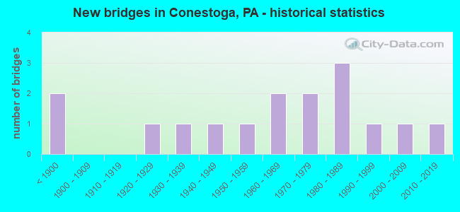
- New bridges - historical statistics
- 2Before 1900
- 11920-1929
- 11930-1939
- 11940-1949
- 11950-1959
- 21960-1969
- 21970-1979
- 31980-1989
- 11990-1999
- 12000-2009
- 12010-2019

- Reconstructed bridges - Historical Statistics
- 31980-1989
- 01990-1999
- 12000-2009
- 12010-2019


- Bridge Condition - Deck
- 15.4%Very good
- 15.4%Good
- 53.8%Satisfactory
- 15.4%Fair

- Bridge Condition - Superstructure
- 23.1%Very good
- 15.4%Good
- 38.5%Satisfactory
- 23.1%Fair

- Bridge Condition - Substructure
- 30.8%Good
- 38.5%Satisfactory
- 30.8%Fair

- Bridge Condition - Channel
- 13.3%Very good
- 20.0%Good
- 40.0%Satisfactory
- 20.0%Fair
- 6.7%Poor

- Bridge Condition - Culverts
- 33.3%Very good
- 33.3%Satisfactory
- 33.3%Poor
Find on map >> Show street view
Structure Number: 21213, Location: MARTIC FORGE (Lat: 39.905592, Lng: -76.326636), Route carried "on" structure: State highway 324, Year Built: 1970, Status: Open, Structure Length: 0.64m (2.10ft), Average Daily Traffic: 2,472 (year 2020), Truck Traffic: 9%, Average Future Daily Traffic: 1,985 (year 2032), Design Load: HS 20, Features Intersected: TRIB PEQUEA CREEK
Minimum Vertical Clearance: 30+ m (98+ ft), Kilometerpoint: 4.926, Lanes on structure: 2, Owner: State Highway Agency, Approaching Roadway Width: 11.9m (39.0ft), Skew: 3 degrees, Material/Design: Concrete, Design/Construction: Culvert, Number Of Spans In Main Unit: 1, Length of Maximum Span: 6.4m (21.0ft), Curb-To-Curb Width: 13.4m (44.0ft), Out-to-Out Width: 14.0m (45.9ft)
Condition: Channel: Satisfactory, Culverts: Satisfactory, Operating Rating: 49.0 metric tons, Method Used To Determine Operating Rating: Load Factor (LF), Inventory Rating: 29.0 metric tons, Method Used To Determine Inventory Rating: Load Factor (LF), Structural Evaluation: Equal to present minimum criteria, Deck Geometry: Better than present minimum criteria, Waterway Adequacy: Equal to present minimum criteria, Approach Roadway Alignment: Equal to present desirable criteria, Length Of Structure Improvement: 1.30m (4.27ft), Designated Inspection Frequency: Every 24 months, Inspection Date: November 2019, Wearing Surface/Protective System: Wearing Surface: Bituminous, Membrane: Preformed Fabric
Find on map >> Show street view
Structure Number: 21217, Location: 1 MI. N. MARTIC FORGE (Lat: 39.916278, Lng: -76.310106), Route carried "on" structure: State highway 324, Year Built: 1982, Status: Open, Structure Length: 0.73m (2.40ft), Average Daily Traffic: 3,119 (year 2022), Truck Traffic: 12%, Average Future Daily Traffic: 3,175 (year 2032), Design Load: HS 20, Features Intersected: CLIMBERS RUN
Minimum Vertical Clearance: 30+ m (98+ ft), Kilometerpoint: 7.670, Lanes on structure: 2, Owner: State Highway Agency, Approaching Roadway Width: 8.2m (26.9ft), Skew: 2 degrees, Material/Design: Concrete, Design/Construction: Frame, Number Of Spans In Main Unit: 1, Length of Maximum Span: 6.7m (22.0ft), Curb-To-Curb Width: 8.5m (27.9ft), Out-to-Out Width: 9.6m (31.5ft)
Condition: Deck: Satisfactory, Superstructure: Satisfactory, Substructure: Good, Channel: Satisfactory, Operating Rating: 56.2 metric tons, Method Used To Determine Operating Rating: Load Factor (LF), Inventory Rating: 33.6 metric tons, Method Used To Determine Inventory Rating: Load Factor (LF), Structural Evaluation: Equal to present minimum criteria, Deck Geometry: Meets minimum limits, Waterway Adequacy: Equal to present minimum criteria, Approach Roadway Alignment: Equal to present desirable criteria, Length Of Structure Improvement: 1.40m (4.59ft), Designated Inspection Frequency: Every 24 months, Inspection Date: November 2019, Wearing Surface/Protective System: Wearing Surface: Monolithic Concrete, Deck Protection: Epoxy Coated Reinforcing
Find on map >> Show street view
Structure Number: 21218, Location: 1 MI. N. OF MARTICVILLE (Lat: 39.940603, Lng: -76.306917), Route carried "on" structure: State highway 324, Year Built: 1930, Year Reconstructed: 2009, Status: Open, Structure Length: 5.94m (19.49ft), Average Daily Traffic: 2,821 (year 2022), Truck Traffic: 7%, Average Future Daily Traffic: 4,310 (year 2032), Design Load: H 15, Features Intersected: PEQUEA CREEK
Minimum Vertical Clearance: 30+ m (98+ ft), Kilometerpoint: 10.615, Lanes on structure: 2, Owner: State Highway Agency, Approaching Roadway Width: 7.0m (23.0ft), Skew: 4 degrees, Material/Design: Steel continuous, Design/Construction: Stringer/Multi-beam, Number Of Spans In Main Unit: 2, Length of Maximum Span: 26.5m (86.9ft), Curb or Sidewalk Widths: Left: 0.4m (1.3ft), Right: 0.4m (1.3ft), Curb-To-Curb Width: 9.2m (30.2ft), Out-to-Out Width: 10.4m (34.1ft)
Condition: Deck: Good, Superstructure: Very good, Substructure: Fair, Channel: Fair, Inventory Rating: 92.5 metric tons, Method Used To Determine Inventory Rating: Load Factor (LF), Structural Evaluation: Somewhat better than minimum adequacy, Deck Geometry: Meets minimum limits, Waterway Adequacy: Superior to present desirable criteria, Approach Roadway Alignment: Better than present minimum criteria, Length Of Structure Improvement: 6.90m (22.64ft), Designated Inspection Frequency: Every 24 months, Inspection Date: October 2019, Bridge Improvement Cost: $101,000, Roadway Improvement Cost: $296,000, Total Project Cost: $1,359,000, Deck Structure Type: Concrete Cast-file-Place, Wearing Surface/Protective System: Wearing Surface: Monolithic Concrete, Deck Protection: Epoxy Coated Reinforcing
Find on map >> Show street view
Structure Number: 21629, Location: 0.75 MI N OF SAFE HARBOR (Lat: 39.939067, Lng: -76.387300), Route carried "on" structure: State highway , Year Built: 1986, Status: Open, Structure Length: 8.99m (29.49ft), Average Daily Traffic: 2,103 (year 2022), Truck Traffic: 5%, Average Future Daily Traffic: 1,784 (year 2032), Design Load: HS 25 or greater, Features Intersected: CONESTOGA RIVER, Facility Carried by Structure: SR 3017
Minimum Vertical Clearance: 30+ m (98+ ft), Kilometerpoint: 10.728, Lanes on structure: 2, Owner: State Highway Agency, Approaching Roadway Width: 8.5m (27.9ft), Material/Design: Prestressed concrete, Design/Construction: Box Beam or Girders - Single/Spread, Number Of Spans In Main Unit: 4, Length of Maximum Span: 21.9m (71.9ft), Curb or Sidewalk Widths: Left: 1.5m (4.9ft), Right: 0.2m (0.7ft), Curb-To-Curb Width: 8.4m (27.6ft), Out-to-Out Width: 11.4m (37.4ft)
Condition: Deck: Satisfactory, Superstructure: Fair, Substructure: Fair, Channel: Good, Operating Rating: 63.5 metric tons, Method Used To Determine Operating Rating: Load Factor (LF), Inventory Rating: 38.1 metric tons, Method Used To Determine Inventory Rating: Load Factor (LF), Structural Evaluation: Somewhat better than minimum adequacy, Deck Geometry: High priority of corrective action, Waterway Adequacy: Superior to present desirable criteria, Approach Roadway Alignment: Equal to present desirable criteria, Length Of Structure Improvement: 11.20m (36.75ft), Designated Inspection Frequency: Every 24 months, Inspection Date: April 2020, Deck Structure Type: Concrete Cast-file-Place, Wearing Surface/Protective System: Wearing Surface: Latex Concrete, Deck Protection: Epoxy Coated Reinforcing
Find on map >> Show street view
Structure Number: 2163, Location: 0.5 mi.N.W. Safe Harbor (Lat: 39.939417, Lng: -76.390453), Route carried "on" structure: State highway , Year Built: 1943, Year Reconstructed: 1994, Status: Open, Structure Length: 0.91m (2.99ft), Average Daily Traffic: 2,103 (year 2022), Truck Traffic: 5%, Average Future Daily Traffic: 1,784 (year 2032), Design Load: HS 25 or greater, Features Intersected: Trib Conestoga River, Facility Carried by Structure: SR 3017; River Rd
Minimum Vertical Clearance: 30+ m (98+ ft), Kilometerpoint: 10.728, Lanes on structure: 2, Owner: State Highway Agency, Approaching Roadway Width: 7.6m (24.9ft), Skew: 1 degrees, Material/Design: Steel, Design/Construction: Stringer/Multi-beam, Number Of Spans In Main Unit: 1, Length of Maximum Span: 7.9m (25.9ft), Curb-To-Curb Width: 8.5m (27.9ft), Out-to-Out Width: 9.8m (32.2ft)
Condition: Deck: Satisfactory, Superstructure: Fair, Substructure: Fair, Channel: Satisfactory, Operating Rating: 69.9 metric tons, Method Used To Determine Operating Rating: Load Factor (LF), Inventory Rating: 41.7 metric tons, Method Used To Determine Inventory Rating: Load Factor (LF), Structural Evaluation: Somewhat better than minimum adequacy, Deck Geometry: Meets minimum limits, Waterway Adequacy: Better than present minimum criteria, Approach Roadway Alignment: Equal to present desirable criteria, Length Of Structure Improvement: 1.60m (5.25ft), Designated Inspection Frequency: Every 24 months, Inspection Date: April 2020, Deck Structure Type: Concrete Cast-file-Place, Wearing Surface/Protective System: Wearing Surface: Monolithic Concrete, Deck Protection: Epoxy Coated Reinforcing
Find on map >> Show street view
Structure Number: 21631, Location: 0.6 mi.N.W. Safe Harbor (Lat: 39.941800, Lng: -76.391464), Route carried "on" structure: State highway , Year Built: 1984, Status: Open, Structure Length: 0.76m (2.49ft), Average Daily Traffic: 504 (year 2022), Truck Traffic: 19%, Average Future Daily Traffic: 663 (year 2032), Design Load: HS 25 or greater, Features Intersected: Witmer Run, Facility Carried by Structure: SR 3017;Safe Harbr
Minimum Vertical Clearance: 30+ m (98+ ft), Kilometerpoint: 10.728, Lanes on structure: 2, Owner: State Highway Agency, Approaching Roadway Width: 8.5m (27.9ft), Skew: 2 degrees, Material/Design: Concrete, Design/Construction: Frame, Number Of Spans In Main Unit: 1, Length of Maximum Span: 7.0m (23.0ft), Curb-To-Curb Width: 8.5m (27.9ft), Out-to-Out Width: 9.7m (31.8ft)
Condition: Deck: Satisfactory, Superstructure: Satisfactory, Substructure: Satisfactory, Channel: Satisfactory, Operating Rating: 80.7 metric tons, Method Used To Determine Operating Rating: Load Factor (LF), Inventory Rating: 48.1 metric tons, Method Used To Determine Inventory Rating: Load Factor (LF), Structural Evaluation: Equal to present minimum criteria, Deck Geometry: Somewhat better than minimum adequacy, Waterway Adequacy: Better than present minimum criteria, Approach Roadway Alignment: Equal to present desirable criteria, Length Of Structure Improvement: 1.30m (4.27ft), Designated Inspection Frequency: Every 24 months, Inspection Date: April 2020, Wearing Surface/Protective System: Wearing Surface: Monolithic Concrete, Deck Protection: Epoxy Coated Reinforcing
Find on map >> Show street view
Structure Number: 21646, Location: 1 MI NW MARTICVILLE (Lat: 39.933622, Lng: -76.322358), Route carried "on" structure: State highway , Year Built: 1950, Year Reconstructed: 2018, Status: Open, Structure Length: 2.90m (9.51ft), Average Daily Traffic: 565 (year 2022), Truck Traffic: 7%, Average Future Daily Traffic: 795 (year 2032), Design Load: HL 93, Features Intersected: PEQUEA CREEK, Facility Carried by Structure: FROGTOWN RD.
Minimum Vertical Clearance: 30+ m (98+ ft), Kilometerpoint: 1.411, Lanes on structure: 2, Owner: State Highway Agency, Approaching Roadway Width: 7.3m (24.0ft), Material/Design: Steel continuous, Design/Construction: Stringer/Multi-beam, Number Of Spans In Main Unit: 2, Length of Maximum Span: 14.0m (45.9ft), Curb-To-Curb Width: 7.3m (24.0ft), Out-to-Out Width: 8.2m (26.9ft)
Condition: Deck: Very good, Superstructure: Very good, Substructure: Satisfactory, Channel: Satisfactory, Operating Rating: 55.3 metric tons, Method Used To Determine Operating Rating: Assigned ratings based on Load and Resistance Factor Design (LRFD) reported in metric tons, Inventory Rating: 42.6 metric tons, Method Used To Determine Inventory Rating: Assigned ratings based on Load and Resistance Factor Design (LRFD) reported in metric tons, Structural Evaluation: Equal to present minimum criteria, Deck Geometry: Meets minimum limits, Waterway Adequacy: Better than present minimum criteria, Approach Roadway Alignment: Somewhat better than minimum adequacy, Length Of Structure Improvement: 2.80m (9.19ft), Designated Inspection Frequency: Every 24 months, Inspection Date: March 2021, Bridge Improvement Cost: $49,000, Roadway Improvement Cost: $143,000, Total Project Cost: $656,000, Deck Structure Type: Concrete Cast-file-Place, Wearing Surface/Protective System: Wearing Surface: Monolithic Concrete, Deck Protection: Epoxy Coated Reinforcing
Find on map >> Show street view
Structure Number: 21659, Location: 2 MI. N. OF SAFE HARBOR (Lat: 39.961647, Lng: -76.364178), Route carried "on" structure: State highway , Year Built: 1969, Status: Open, Structure Length: 1.19m (3.90ft), Average Daily Traffic: 605 (year 2022), Truck Traffic: 5%, Average Future Daily Traffic: 864 (year 2032), Design Load: HS 20, Features Intersected: STEHMAN RUN, Facility Carried by Structure: SR 3030 SLACKWATER
Minimum Vertical Clearance: 30+ m (98+ ft), Kilometerpoint: 14.248, Lanes on structure: 2, Owner: State Highway Agency, Approaching Roadway Width: 11.0m (36.1ft), Skew: 3 degrees, Material/Design: Prestressed concrete, Design/Construction: Box Beam or Girders - Single/Spread, Number Of Spans In Main Unit: 1, Length of Maximum Span: 11.3m (37.1ft), Curb-To-Curb Width: 11.2m (36.7ft), Out-to-Out Width: 12.2m (40.0ft)
Condition: Deck: Fair, Superstructure: Good, Substructure: Satisfactory, Channel: Fair, Operating Rating: 84.4 metric tons, Method Used To Determine Operating Rating: Load Factor (LF), Inventory Rating: 39.9 metric tons, Method Used To Determine Inventory Rating: Load Factor (LF), Structural Evaluation: Equal to present minimum criteria, Deck Geometry: Better than present minimum criteria, Waterway Adequacy: Equal to present minimum criteria, Approach Roadway Alignment: Somewhat better than minimum adequacy, Length Of Structure Improvement: 1.80m (5.91ft), Designated Inspection Frequency: Every 24 months, Inspection Date: April 2020, Deck Structure Type: Concrete Cast-file-Place, Wearing Surface/Protective System: Wearing Surface: Monolithic Concrete
Find on map >> Show street view
Structure Number: 21872, Location: 3/4 MI SW OF T-440 (Lat: 39.907600, Lng: -76.345100), Route carried "on" structure: City street , Year Built: 1990, Status: Open, Structure Length: 5.18m (16.99ft), Average Daily Traffic: 260 (year 2011), Truck Traffic: 2%, Average Future Daily Traffic: 350 (year 2031), Features Intersected: ENOLA LOW GRADE TRAIL, Facility Carried by Structure: T-419River Hill Rd
Minimum Vertical Clearance: 30+ m (98+ ft), Kilometerpoint: 0.000, Lanes on structure: 2, Owner: Town or Township Highway Agency, Approaching Roadway Width: 8.5m (27.9ft), Material/Design: Steel, Design/Construction: Stringer/Multi-beam, Number Of Spans In Main Unit: 1, Length of Maximum Span: 51.2m (168.0ft), Curb-To-Curb Width: 8.5m (27.9ft), Out-to-Out Width: 9.6m (31.5ft)
Condition: Deck: Good, Superstructure: Good, Substructure: Good, Inventory Rating: 80.7 metric tons, Method Used To Determine Inventory Rating: Load Factor (LF), Structural Evaluation: Better than present minimum criteria, Deck Geometry: Equal to present minimum criteria, Approach Roadway Alignment: Somewhat better than minimum adequacy, Length Of Structure Improvement: 6.20m (20.34ft), Designated Inspection Frequency: Every 24 months, Inspection Date: October 2019, Deck Structure Type: Concrete Cast-file-Place, Wearing Surface/Protective System: Wearing Surface: Monolithic Concrete, Deck Protection: Epoxy Coated Reinforcing
Find on map >> Show street view
Structure Number: 21878, Location: AT SR 3030 INTERSECTION (Lat: 39.961597, Lng: -76.365600), Route carried "on" structure: City street , Year Built: 1923, Status: Posted for load, Structure Length: 7.80m (25.59ft), Average Daily Traffic: 400 (year 2012), Truck Traffic: 2%, Average Future Daily Traffic: 535 (year 2032), Design Load: HS 20, Features Intersected: CONESTOGA RIVER, Facility Carried by Structure: ROCK HILL RD
Minimum Vertical Clearance: 5.59m (18.34ft), Kilometerpoint: 0.000, Lanes on structure: 1, Owner: County Highway Agency, Approaching Roadway Width: 4.9m (16.1ft), Material/Design: Steel, Design/Construction: Truss - Thru, Number Of Spans In Main Unit: 2, Length of Maximum Span: 39.0m (128.0ft), Curb-To-Curb Width: 4.7m (15.4ft), Out-to-Out Width: 5.2m (17.1ft)
Condition: Deck: Satisfactory, Superstructure: Satisfactory, Substructure: Fair, Channel: Good, Operating Rating: 37.2 metric tons, Method Used To Determine Operating Rating: Load Factor (LF), Inventory Rating: 21.8 metric tons, Method Used To Determine Inventory Rating: Load Factor (LF), Structural Evaluation: Somewhat better than minimum adequacy, Deck Geometry: High priority of replacement, Waterway Adequacy: Equal to present desirable criteria, Approach Roadway Alignment: Somewhat better than minimum adequacy, Bridge Posting: Required (Relationship of Operating Rating to Maximum Legal Load: 10.0 - 19.9% below), Length Of Structure Improvement: 7.80m (25.59ft), Designated Inspection Frequency: Every 24 months, Critical Feature Inspection Frequency: Every 12 months, Other Special Inspection Frequency: Every 12 months, Inspection Date: June 2020, Critical Feature Inspection Date: June 2021, Other Special Inspection Date: June 2021, Bridge Improvement Cost: $10,000, Roadway Improvement Cost: $28,000, Total Project Cost: $129,000, Deck Structure Type: Open Grating
Find on map >> Show street view
Structure Number: 21976, Location: 1300 FT NW OF SR 3027 (Lat: 39.964200, Lng: -76.384358), Route carried "on" structure: City street , Year Built: 1973, Status: Open, Structure Length: 0.94m (3.08ft), Average Daily Traffic: 105 (year 2011), Truck Traffic: 6%, Average Future Daily Traffic: 140 (year 2031), Design Load: HS 20, Features Intersected: INDIAN RUN, Facility Carried by Structure: T563 INDIAN RUN RD
Minimum Vertical Clearance: 30+ m (98+ ft), Kilometerpoint: 0.000, Lanes on structure: 2, Owner: Town or Township Highway Agency, Approaching Roadway Width: 9.1m (29.9ft), Skew: 3 degrees, Material/Design: Prestressed concrete, Design/Construction: Box Beam or Girders - Multiple, Number Of Spans In Main Unit: 1, Length of Maximum Span: 9.1m (29.9ft), Curb-To-Curb Width: 7.9m (25.9ft), Out-to-Out Width: 9.1m (29.9ft)
Condition: Deck: Fair, Superstructure: Fair, Substructure: Satisfactory, Channel: Fair, Operating Rating: 54.4 metric tons, Method Used To Determine Operating Rating: Load Factor (LF), Inventory Rating: 23.6 metric tons, Method Used To Determine Inventory Rating: Load Factor (LF), Structural Evaluation: Somewhat better than minimum adequacy, Deck Geometry: Somewhat better than minimum adequacy, Waterway Adequacy: Superior to present desirable criteria, Approach Roadway Alignment: Equal to present desirable criteria, Length Of Structure Improvement: 1.60m (5.25ft), Designated Inspection Frequency: Every 24 months, Inspection Date: October 2019, Deck Structure Type: Other, Wearing Surface/Protective System: Wearing Surface: Bituminous, Membrane: Preformed Fabric
Find on map >> Show street view
Structure Number: 21984, Location: 1000 FT SOUTH OF SR 324 (Lat: 39.898878, Lng: -76.342097), Route carried "on" structure: City street , Year Built: 1878, Year Reconstructed: 1992, Status: Posted for load, Structure Length: 4.72m (15.49ft), Average Daily Traffic: 340 (year 2012), Average Future Daily Traffic: 400 (year 2032), Design Load: HS 20, Features Intersected: PEQUEA CREEK, Facility Carried by Structure: FOX HOLLOW RD
Minimum Vertical Clearance: 3.51m (11.52ft), Kilometerpoint: 0.000, Lanes on structure: 1, Owner: County Highway Agency, Approaching Roadway Width: 6.1m (20.0ft), Material/Design: Wood or Timber, Design/Construction: Truss - Thru, Number Of Spans In Main Unit: 1, Length of Maximum Span: 47.2m (154.9ft), Curb-To-Curb Width: 4.4m (14.4ft), Out-to-Out Width: 5.5m (18.0ft)
Condition: Deck: Satisfactory, Superstructure: Satisfactory, Substructure: Good, Channel: Good, Operating Rating: 4.5 metric tons, Method Used To Determine Operating Rating: Allowable Stress (AS), Inventory Rating: 2.7 metric tons, Method Used To Determine Inventory Rating: Allowable Stress (AS), Structural Evaluation: High priority of corrective action, Deck Geometry: High priority of replacement, Waterway Adequacy: Equal to present desirable criteria, Approach Roadway Alignment: Equal to present minimum criteria, Bridge Posting: Required (Relationship of Operating Rating to Maximum Legal Load: > 39.9% below), Length Of Structure Improvement: 4.70m (15.42ft), Designated Inspection Frequency: Every 24 months, Other Special Inspection Frequency: Every 12 months, Inspection Date: September 2020, Other Special Inspection Date: September 2021, Bridge Improvement Cost: $8,000, Roadway Improvement Cost: $23,000, Total Project Cost: $107,000, Deck Structure Type: Wood or Timber
Find on map >> Show street view
Structure Number: 22018, Location: 1 MI NE OF SR 324 (Lat: 39.930639, Lng: -76.295244), Route carried "on" structure: City street , Year Built: 1860, Year Reconstructed: 1987, Status: Posted for load, Structure Length: 3.20m (10.50ft), Average Daily Traffic: 400 (year 2012), Average Future Daily Traffic: 535 (year 2032), Design Load: HS 20, Features Intersected: PEQUEA CREEK, Facility Carried by Structure: BYERLAND CHURCH RD
Minimum Vertical Clearance: 3.20m (10.50ft), Kilometerpoint: 0.000, Lanes on structure: 2, Owner: County Highway Agency, Approaching Roadway Width: 6.1m (20.0ft), Material/Design: Wood or Timber, Design/Construction: Truss - Thru, Number Of Spans In Main Unit: 1, Length of Maximum Span: 32.0m (105.0ft), Curb-To-Curb Width: 4.3m (14.1ft), Out-to-Out Width: 5.4m (17.7ft)
Condition: Deck: Satisfactory, Superstructure: Satisfactory, Substructure: Satisfactory, Channel: Satisfactory, Operating Rating: 3.6 metric tons, Method Used To Determine Operating Rating: Allowable Stress (AS), Inventory Rating: 1.8 metric tons, Method Used To Determine Inventory Rating: Allowable Stress (AS), Structural Evaluation: High priority of corrective action, Waterway Adequacy: Equal to present desirable criteria, Approach Roadway Alignment: Equal to present minimum criteria, Bridge Posting: Required (Relationship of Operating Rating to Maximum Legal Load: > 39.9% below), Length Of Structure Improvement: 4.00m (13.12ft), Designated Inspection Frequency: Every 24 months, Other Special Inspection Frequency: Every 12 months, Inspection Date: October 2020, Other Special Inspection Date: October 2020, Bridge Improvement Cost: $5,000, Roadway Improvement Cost: $15,000, Total Project Cost: $69,000, Deck Structure Type: Wood or Timber
Find on map >> Show street view
Structure Number: 45455, Location: Pequea (Lat: 39.887389, Lng: -76.367183), Route carried "on" structure: State highway 324, Year Built: 2009, Status: Open, Structure Length: 7.56m (24.80ft), Average Daily Traffic: 540 (year 2022), Truck Traffic: 6%, Average Future Daily Traffic: 970 (year 2032), Design Load: HL 93, Features Intersected: Pequea Creek
Minimum Vertical Clearance: 30+ m (98+ ft), Kilometerpoint: 0.525, Lanes on structure: 2, Owner: State Highway Agency, Approaching Roadway Width: 8.2m (26.9ft), Material/Design: Steel, Design/Construction: Stringer/Multi-beam, Number Of Spans In Main Unit: 1, Number Of Approach Spans: 3, Length of Maximum Span: 36.0m (118.1ft), Curb or Sidewalk Widths: Left: 0.2m (0.7ft), Right: 0.2m (0.7ft), Curb-To-Curb Width: 9.7m (31.8ft), Out-to-Out Width: 10.6m (34.8ft)
Condition: Deck: Very good, Superstructure: Very good, Substructure: Good, Channel: Very good, Operating Rating: 82.6 metric tons, Method Used To Determine Operating Rating: Load and Resistance Factor (LRFR), Inventory Rating: 63.5 metric tons, Method Used To Determine Inventory Rating: Load and Resistance Factor (LRFR), Structural Evaluation: Better than present minimum criteria, Deck Geometry: Equal to present minimum criteria, Waterway Adequacy: Superior to present desirable criteria, Approach Roadway Alignment: Equal to present desirable criteria, Designated Inspection Frequency: Every 48 months, Inspection Date: May 2019, Deck Structure Type: Concrete Cast-file-Place, Wearing Surface/Protective System: Wearing Surface: Monolithic Concrete, Deck Protection: Epoxy Coated Reinforcing
Find on map >> Show street view
Structure Number: 54663, Location: 2 MILE SW OF MILLERSVILLE (Lat: 39.966625, Lng: -76.373711), Route carried "on" structure: State highway , Year Built: 2017, Status: Open, Structure Length: 0.79m (2.59ft), Average Daily Traffic: 139 (year 2022), Truck Traffic: 15%, Average Future Daily Traffic: 219 (year 2032), Design Load: HL 93, Features Intersected: INDIAN RUN, Facility Carried by Structure: Walnut Hill Road
Minimum Vertical Clearance: 30+ m (98+ ft), Kilometerpoint: 2.321, Lanes on structure: 2, Owner: State Highway Agency, Approaching Roadway Width: 7.3m (24.0ft), Material/Design: Concrete, Design/Construction: Culvert, Number Of Spans In Main Unit: 1, Length of Maximum Span: 7.3m (24.0ft), Curb-To-Curb Width: 7.3m (24.0ft), Out-to-Out Width: 8.4m (27.6ft)
Condition: Channel: Very good, Culverts: Very good, Operating Rating: 56.4 metric tons, Method Used To Determine Operating Rating: Assigned ratings based on Load and Resistance Factor Design (LRFD) reported by rating factor (RF) using HL93 loadings, Inventory Rating: 37.3 metric tons, Method Used To Determine Inventory Rating: Assigned ratings based on Load and Resistance Factor Design (LRFD) reported by rating factor (RF) using HL93 loadings, Structural Evaluation: Equal to present desirable criteria, Deck Geometry: Somewhat better than minimum adequacy, Waterway Adequacy: Better than present minimum criteria, Approach Roadway Alignment: Equal to present desirable criteria, Designated Inspection Frequency: Every 24 months, Inspection Date: November 2020, Deck Structure Type: Concrete Cast-file-Place, Wearing Surface/Protective System: Wearing Surface: Bituminous, Membrane: Preformed Fabric, Deck Protection: Epoxy Coated Reinforcing
Find on map >> Show street view
Structure Number: 57581, Location: BRIDGE NEXT TO 70 PITTSBU (Lat: 39.946256, Lng: -76.403342), Route carried "on" structure: City street , Year Built: 1965, Status: Open, Structure Length: 0.82m (2.69ft), Average Daily Traffic: 100 (year 2020), Average Future Daily Traffic: 150 (year 2040), Features Intersected: WITMER RUN, Facility Carried by Structure: PITTSBURG VALLEY
Minimum Vertical Clearance: 30+ m (98+ ft), Kilometerpoint: 0.000, Lanes on structure: 2, Owner: Town or Township Highway Agency, Approaching Roadway Width: 6.4m (21.0ft), Skew: 7 degrees, Material/Design: Steel, Design/Construction: Culvert, Number Of Spans In Main Unit: 1, Length of Maximum Span: 3.0m (9.8ft), Curb-To-Curb Width: 8.3m (27.2ft), Out-to-Out Width: 8.9m (29.2ft)
Condition: Channel: Poor, Culverts: Poor, Operating Rating: 72.6 metric tons, Method Used To Determine Operating Rating: Load and Resistance Factor (LRFR), Inventory Rating: 69.9 metric tons, Method Used To Determine Inventory Rating: Load and Resistance Factor (LRFR), Structural Evaluation: Meets minimum limits, Deck Geometry: Equal to present minimum criteria, Waterway Adequacy: Better than present minimum criteria, Approach Roadway Alignment: Equal to present desirable criteria, Designated Inspection Frequency: Every 24 months, Inspection Date: May 2020