Bridge Statistics for Columbia, Alabama (AL)
Condition, Traffic, Stress, Structural Evaluation, Project Costs
- National Bridge Inventory (NBI) Statistics
- 15Number of bridges
- 262ft / 80.2mTotal length
- $23,043,000Total costs
- 27,034Total average daily traffic
- 2,728Total average daily truck traffic
- 37,987Total future (year 2033) average daily traffic
- National Bridge Inventory (NBI) Registered Bridges for Columbia
- No street view available for this location
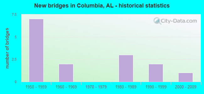
- New bridges - historical statistics
- 71950-1959
- 21960-1969
- 31980-1989
- 21990-1999
- 12000-2009


- Bridge Condition - Deck
- 12.5%Very good
- 50.0%Good
- 25.0%Satisfactory
- 12.5%Fair

- Bridge Condition - Superstructure
- 12.5%Very good
- 37.5%Good
- 37.5%Satisfactory
- 12.5%Fair

- Bridge Condition - Substructure
- 12.5%Very good
- 50.0%Good
- 37.5%Satisfactory

- Bridge Condition - Channel
- 64.3%Good
- 35.7%Satisfactory

- Bridge Condition - Culverts
- 71.4%Good
- 14.3%Satisfactory
- 14.3%Fair
Find on map >> Show street view
Structure Number: 2138, Location: CO RD 38 TO CO RD 42 (Lat: 31.250406, Lng: -85.137775), Route carried "on" structure: County highway , Year Built: 1987, Status: Open, Structure Length: 0.79m (2.59ft), Average Daily Traffic: 135 (year 1993), Truck Traffic: 1%, Average Future Daily Traffic: 250 (year 2033), Design Load: HS 20, Features Intersected: WILSON CREEK, Facility Carried by Structure: MACEDONIA CH RD
Minimum Vertical Clearance: 30+ m (98+ ft), Kilometerpoint: 0.010, Lanes on structure: 2, Owner: County Highway Agency, Approaching Roadway Width: 9.1m (29.9ft), Material/Design: Concrete, Design/Construction: Culvert, Number Of Spans In Main Unit: 2, Length of Maximum Span: 3.7m (12.1ft)
Condition: Channel: Good, Culverts: Good, Operating Rating: 74.3 metric tons, Method Used To Determine Operating Rating: Load Factor (LF), Inventory Rating: 44.5 metric tons, Method Used To Determine Inventory Rating: Load Factor (LF), Structural Evaluation: Better than present minimum criteria, Waterway Adequacy: Better than present minimum criteria, Approach Roadway Alignment: Better than present minimum criteria, Length Of Structure Improvement: 1.44m (4.72ft), Designated Inspection Frequency: Every 24 months, Inspection Date: March 2021, Bridge Improvement Cost: $358,000, Roadway Improvement Cost: $36,000, Total Project Cost: $394,000 ( Estimate for 2022), Wearing Surface/Protective System: Wearing Surface: Bituminous
Find on map >> Show street view
Structure Number: 3713, Location: HENRY CO LINE TO AL52 (Lat: 31.304992, Lng: -85.161467), Route carried "on" structure: County highway 22, Year Built: 1950, Status: Posted for load, Structure Length: 4.15m (13.62ft), Average Daily Traffic: 675 (year 1990), Truck Traffic: 7%, Average Future Daily Traffic: 1,200 (year 2033), Features Intersected: HURRICANE CREEK
Minimum Vertical Clearance: 30+ m (98+ ft), Kilometerpoint: 0.010, Lanes on structure: 2, Owner: County Highway Agency, Approaching Roadway Width: 8.5m (27.9ft), Material/Design: Concrete continuous, Design/Construction: Tee Beam, Number Of Spans In Main Unit: 4, Length of Maximum Span: 10.4m (34.1ft), Curb-To-Curb Width: 6.6m (21.7ft), Out-to-Out Width: 7.2m (23.6ft)
Condition: Deck: Good, Superstructure: Good, Substructure: Good, Channel: Satisfactory, Operating Rating: 35.1 metric tons, Method Used To Determine Operating Rating: Allowable Stress (AS), Inventory Rating: 20.9 metric tons, Method Used To Determine Inventory Rating: Allowable Stress (AS), Structural Evaluation: Somewhat better than minimum adequacy, Deck Geometry: High priority of corrective action, Waterway Adequacy: Better than present minimum criteria, Approach Roadway Alignment: Better than present minimum criteria, Bridge Posting: Required (Relationship of Operating Rating to Maximum Legal Load: 20.0 - 29.9% below), Length Of Structure Improvement: 5.12m (16.80ft), Designated Inspection Frequency: Every 24 months, Other Special Inspection Frequency: Every 12 months, Inspection Date: June 2021, Other Special Inspection Date: June 2021, Bridge Improvement Cost: $807,000, Roadway Improvement Cost: $81,000, Total Project Cost: $888,000 ( Estimate for 2022), Deck Structure Type: Concrete Cast-file-Place
Find on map >> Show street view
Structure Number: 3714, Location: HENRY CO LINE TO AL 52 (Lat: 31.295500, Lng: -85.139731), Route carried "on" structure: County highway 22, Year Built: 1950, Status: Open, Structure Length: 0.63m (2.07ft), Average Daily Traffic: 640 (year 1990), Truck Traffic: 7%, Average Future Daily Traffic: 1,200 (year 2033), Features Intersected: THOMAS CREEK
Minimum Vertical Clearance: 30+ m (98+ ft), Kilometerpoint: 0.010, Lanes on structure: 2, Owner: County Highway Agency, Approaching Roadway Width: 9.1m (29.9ft), Material/Design: Concrete, Design/Construction: Culvert, Number Of Spans In Main Unit: 2, Length of Maximum Span: 3.0m (9.8ft)
Condition: Channel: Good, Culverts: Good, Operating Rating: 88.9 metric tons, Method Used To Determine Operating Rating: Load Factor (LF), Inventory Rating: 83.6 metric tons, Method Used To Determine Inventory Rating: Load Factor (LF), Structural Evaluation: Better than present minimum criteria, Waterway Adequacy: Better than present minimum criteria, Approach Roadway Alignment: Better than present minimum criteria, Length Of Structure Improvement: 1.25m (4.10ft), Designated Inspection Frequency: Every 24 months, Inspection Date: April 2021, Bridge Improvement Cost: $304,000, Roadway Improvement Cost: $30,000, Total Project Cost: $334,000 ( Estimate for 2022), Wearing Surface/Protective System: Wearing Surface: Bituminous
Find on map >> Show street view
Structure Number: 4397, Location: ALA 52 TO CO RD 48 (Lat: 31.281758, Lng: -85.152169), Route carried "on" structure: County highway 54, Year Built: 1952, Status: Open, Structure Length: 0.62m (2.03ft), Average Daily Traffic: 655 (year 1993), Truck Traffic: 7%, Average Future Daily Traffic: 917 (year 2033), Features Intersected: THOMAS CREEK
Minimum Vertical Clearance: 30+ m (98+ ft), Kilometerpoint: 0.010, Lanes on structure: 2, Owner: County Highway Agency, Approaching Roadway Width: 8.5m (27.9ft), Material/Design: Concrete, Design/Construction: Culvert, Number Of Spans In Main Unit: 2, Length of Maximum Span: 2.1m (6.9ft), Curb or Sidewalk Widths: Left: 0.1m (0.3ft), Right: 0.0m
Condition: Channel: Satisfactory, Culverts: Satisfactory, Operating Rating: 86.5 metric tons, Method Used To Determine Operating Rating: Load Factor (LF), Inventory Rating: 51.9 metric tons, Method Used To Determine Inventory Rating: Load Factor (LF), Structural Evaluation: Equal to present minimum criteria, Waterway Adequacy: Better than present minimum criteria, Approach Roadway Alignment: Better than present minimum criteria, Length Of Structure Improvement: 1.24m (4.07ft), Designated Inspection Frequency: Every 24 months, Inspection Date: August 2021, Bridge Improvement Cost: $237,000, Roadway Improvement Cost: $24,000, Total Project Cost: $261,000 ( Estimate for 2022), Wearing Surface/Protective System: Wearing Surface: Bituminous
Find on map >> Show street view
Structure Number: 59, Location: .5 MILE WEST OF BROOKLYN (Lat: 31.312744, Lng: -85.178589), Route carried "on" structure: County highway 432, Year Built: 1991, Status: Open, Structure Length: 1.10m (3.61ft), Average Daily Traffic: 100 (year 2020), Average Future Daily Traffic: 125 (year 2040), Design Load: HS 20, Features Intersected: PAGES CREEK
Minimum Vertical Clearance: 30+ m (98+ ft), Kilometerpoint: 0.010, Lanes on structure: 2, Owner: County Highway Agency, Approaching Roadway Width: 8.5m (27.9ft), Skew: 3 degrees, Material/Design: Concrete, Design/Construction: Culvert, Number Of Spans In Main Unit: 3, Length of Maximum Span: 3.7m (12.1ft)
Condition: Channel: Good, Culverts: Good, Operating Rating: 88.9 metric tons, Method Used To Determine Operating Rating: Load Factor (LF), Inventory Rating: 54.4 metric tons, Method Used To Determine Inventory Rating: Load Factor (LF), Structural Evaluation: Better than present minimum criteria, Waterway Adequacy: Better than present minimum criteria, Approach Roadway Alignment: Better than present minimum criteria, Length Of Structure Improvement: 1.77m (5.81ft), Designated Inspection Frequency: Every 24 months, Inspection Date: July 2020, Bridge Improvement Cost: $523,000, Roadway Improvement Cost: $52,000, Total Project Cost: $575,000 ( Estimate for 2022)
Find on map >> Show street view
Structure Number: 637, Location: 4 MI. S. SR 52 (Lat: 31.234650, Lng: -85.124117), Route carried "on" structure: County highway 95, Year Built: 1958, Year Reconstructed: 2009, Status: Open, Structure Length: 1.14m (3.74ft), Average Daily Traffic: 700 (year 2011), Truck Traffic: 7%, Average Future Daily Traffic: 1,090 (year 2033), Design Load: H 15, Features Intersected: BRANCH
Minimum Vertical Clearance: 30+ m (98+ ft), Kilometerpoint: 28.839, Lanes on structure: 2, Owner: County Highway Agency, Approaching Roadway Width: 9.8m (32.2ft), Material/Design: Concrete, Design/Construction: Culvert, Number Of Spans In Main Unit: 3, Length of Maximum Span: 3.7m (12.1ft)
Condition: Channel: Good, Culverts: Good, Operating Rating: 79.5 metric tons, Method Used To Determine Operating Rating: Load Factor (LF), Inventory Rating: 47.7 metric tons, Method Used To Determine Inventory Rating: Load Factor (LF), Structural Evaluation: Better than present minimum criteria, Waterway Adequacy: Equal to present desirable criteria, Approach Roadway Alignment: Equal to present desirable criteria, Length Of Structure Improvement: 1.82m (5.97ft), Designated Inspection Frequency: Every 24 months, Inspection Date: March 2021, Bridge Improvement Cost: $588,000, Roadway Improvement Cost: $59,000, Total Project Cost: $647,000 ( Estimate for 2022)
Find on map >> Show street view
Structure Number: 6627, Location: 0.6 MI.E.SR.95 NORTH (Lat: 31.289617, Lng: -85.103567), Route carried "on" structure: State highway 52, Year Built: 1959, Status: Open, Structure Length: 9.33m (30.61ft), Average Daily Traffic: 5,850 (year 2013), Truck Traffic: 9%, Average Future Daily Traffic: 8,004 (year 2033), Design Load: HS 20, Features Intersected: CHATTAHOOCHEE RV. RELIEF
Minimum Vertical Clearance: 30+ m (98+ ft), Kilometerpoint: 132.491, Lanes on structure: 2, Base Highway Network: Yes, Owner: State Highway Agency, Approaching Roadway Width: 13.7m (44.9ft), Material/Design: Concrete, Design/Construction: Tee Beam, Number Of Spans In Main Unit: 9, Length of Maximum Span: 10.4m (34.1ft), Curb or Sidewalk Widths: Left: 0.5m (1.6ft), Right: 0.5m (1.6ft), Curb-To-Curb Width: 8.5m (27.9ft), Out-to-Out Width: 10.1m (33.1ft)
Condition: Deck: Fair, Superstructure: Fair, Substructure: Good, Channel: Good, Operating Rating: 44.0 metric tons, Method Used To Determine Operating Rating: Load Factor (LF), Inventory Rating: 26.4 metric tons, Method Used To Determine Inventory Rating: Load Factor (LF), Structural Evaluation: Somewhat better than minimum adequacy, Deck Geometry: Meets minimum limits, Waterway Adequacy: Equal to present desirable criteria, Approach Roadway Alignment: Equal to present desirable criteria, Length Of Structure Improvement: 10.28m (33.73ft), Designated Inspection Frequency: Every 24 months, Inspection Date: August 2020, Bridge Improvement Cost: $2,327,000, Roadway Improvement Cost: $233,000, Total Project Cost: $2,560,000 ( Estimate for 2022), Deck Structure Type: Concrete Cast-file-Place
Find on map >> Show street view
Structure Number: 6628, Location: ALA * GA STATE LINE (Lat: 31.285483, Lng: -85.100822), Route carried "on" structure: State highway 52, Year Built: 1959, Status: Open, Structure Length: 34.81m (114.21ft), Average Daily Traffic: 4,620 (year 2013), Truck Traffic: 15%, Average Future Daily Traffic: 6,321 (year 2033), Design Load: HS 20, Features Intersected: CHATTAHOOCHEE RIVER
Minimum Vertical Clearance: 30+ m (98+ ft), Kilometerpoint: 133.014, Lanes on structure: 2, Base Highway Network: Yes, Owner: State Highway Agency, Approaching Roadway Width: 13.4m (44.0ft), Navigation Control: Yes ( Vertical Clearance: 10.7m (35.1ft), Horizontal Clearance: 51.8m (169.9ft)), Material/Design: Steel continuous, Design/Construction: Stringer/Multi-beam, Number Of Spans In Main Unit: 3, Number Of Approach Spans: 20, Length of Maximum Span: 54.9m (180.1ft), Curb or Sidewalk Widths: Left: 0.5m (1.6ft), Right: 0.5m (1.6ft), Curb-To-Curb Width: 8.5m (27.9ft), Out-to-Out Width: 10.1m (33.1ft)
Condition: Deck: Satisfactory, Superstructure: Satisfactory, Substructure: Satisfactory, Channel: Satisfactory, Operating Rating: 47.0 metric tons, Method Used To Determine Operating Rating: Load Factor (LF), Inventory Rating: 28.1 metric tons, Method Used To Determine Inventory Rating: Load Factor (LF), Structural Evaluation: Equal to present minimum criteria, Deck Geometry: Meets minimum limits, Waterway Adequacy: Equal to present desirable criteria, Approach Roadway Alignment: Equal to present desirable criteria, Length Of Structure Improvement: 34.81m (114.21ft), Designated Inspection Frequency: Every 24 months, Critical Feature Inspection Frequency: Every 12 months, Underwater Inspection Frequency: Every 24 months, Inspection Date: August 2020, Critical Feature Inspection Date: October 2021, Underwater Inspection Date: December 2020, Bridge Improvement Cost: $7,876,000, Roadway Improvement Cost: $788,000, Total Project Cost: $8,664,000 ( Estimate for 2022), Deck Structure Type: Concrete Cast-file-Place
Find on map >> Show street view
Structure Number: 7052, Location: .5 MI. EAST SR.#95 NORTH (Lat: 31.290650, Lng: -85.104250), Route carried "on" structure: State highway A0052, Year Built: 1960, Status: Open, Structure Length: 3.84m (12.60ft), Average Daily Traffic: 5,850 (year 2013), Truck Traffic: 9%, Average Future Daily Traffic: 8,004 (year 2033), Design Load: HS 20, Features Intersected: BAYLINE * C.O.G R.R., Facility Carried by Structure: SR 52 MP 82.257
Minimum Vertical Clearance: 30+ m (98+ ft), Kilometerpoint: 132.380, Lanes on structure: 2, Base Highway Network: Yes, Owner: State Highway Agency, Approaching Roadway Width: 13.7m (44.9ft), Material/Design: Concrete, Design/Construction: Tee Beam, Number Of Spans In Main Unit: 3, Length of Maximum Span: 12.8m (42.0ft), Curb or Sidewalk Widths: Left: 0.5m (1.6ft), Right: 0.5m (1.6ft), Curb-To-Curb Width: 8.5m (27.9ft), Out-to-Out Width: 10.1m (33.1ft)
Condition: Deck: Satisfactory, Superstructure: Satisfactory, Substructure: Satisfactory, Operating Rating: 55.7 metric tons, Method Used To Determine Operating Rating: Load Factor (LF), Inventory Rating: 33.4 metric tons, Method Used To Determine Inventory Rating: Load Factor (LF), Structural Evaluation: Equal to present minimum criteria, Deck Geometry: High priority of replacement, Underclear: Equal to present minimum criteria, Approach Roadway Alignment: Equal to present desirable criteria, Length Of Structure Improvement: 4.78m (15.68ft), Designated Inspection Frequency: Every 24 months, Inspection Date: August 2020, Bridge Improvement Cost: $1,082,000, Roadway Improvement Cost: $108,000, Total Project Cost: $1,190,000 ( Estimate for 2022), Deck Structure Type: Concrete Cast-file-Place
Find on map >> Show street view
Structure Number: 7881, Location: RCDG BR. ON PAVED RD. 63 (Lat: 31.342058, Lng: -85.177244), Route carried "on" structure: County highway , Year Built: 1963, Status: Posted for load, Structure Length: 5.82m (19.09ft), Average Daily Traffic: 150 (year 2014), Truck Traffic: 1%, Average Future Daily Traffic: 250 (year 2034), Design Load: H 20, Features Intersected: OMUSSEE CREEK, Facility Carried by Structure: ROAD
Minimum Vertical Clearance: 30+ m (98+ ft), Kilometerpoint: 0.010, Lanes on structure: 2, Owner: County Highway Agency, Approaching Roadway Width: 7.3m (24.0ft), Material/Design: Steel, Design/Construction: Stringer/Multi-beam, Number Of Spans In Main Unit: 1, Number Of Approach Spans: 4, Length of Maximum Span: 16.8m (55.1ft), Curb-To-Curb Width: 7.3m (24.0ft), Out-to-Out Width: 7.6m (24.9ft)
Condition: Deck: Good, Superstructure: Satisfactory, Substructure: Good, Channel: Good, Operating Rating: 34.8 metric tons, Method Used To Determine Operating Rating: Allowable Stress (AS), Inventory Rating: 19.2 metric tons, Method Used To Determine Inventory Rating: Allowable Stress (AS), Structural Evaluation: Somewhat better than minimum adequacy, Deck Geometry: Somewhat better than minimum adequacy, Waterway Adequacy: Better than present minimum criteria, Approach Roadway Alignment: Better than present minimum criteria, Bridge Posting: Required (Relationship of Operating Rating to Maximum Legal Load: 0.1 - 9.9% below), Length Of Structure Improvement: 6.86m (22.51ft), Designated Inspection Frequency: Every 24 months, Underwater Inspection Frequency: Every 48 months, Other Special Inspection Frequency: Every 12 months, Inspection Date: November 2020, Underwater Inspection Date: December 2018, Other Special Inspection Date: December 2021, Bridge Improvement Cost: $1,128,000, Roadway Improvement Cost: $113,000, Total Project Cost: $1,241,000 ( Estimate for 2022), Deck Structure Type: Concrete Cast-file-Place
Find on map >> Show street view
Structure Number: 12396, Location: .4 mi.e. co. rd. 95 south (Lat: 31.292714, Lng: -85.126222), Route carried "on" structure: State highway 52, Year Built: 1980, Status: Open, Structure Length: 6.80m (22.31ft), Average Daily Traffic: 5,280 (year 2013), Truck Traffic: 10%, Average Future Daily Traffic: 7,224 (year 2033), Design Load: HS 20, Features Intersected: OMUSSEE CREEK
Minimum Vertical Clearance: 30+ m (98+ ft), Kilometerpoint: 130.156, Lanes on structure: 2, Base Highway Network: Yes, Owner: State Highway Agency, Approaching Roadway Width: 13.4m (44.0ft), Material/Design: Steel, Design/Construction: Stringer/Multi-beam, Number Of Spans In Main Unit: 1, Number Of Approach Spans: 3, Length of Maximum Span: 36.9m (121.1ft), Curb-To-Curb Width: 13.4m (44.0ft), Out-to-Out Width: 14.3m (46.9ft)
Condition: Deck: Good, Superstructure: Good, Substructure: Good, Channel: Good, Operating Rating: 44.5 metric tons, Method Used To Determine Operating Rating: Load Factor (LF), Inventory Rating: 26.7 metric tons, Method Used To Determine Inventory Rating: Load Factor (LF), Structural Evaluation: Equal to present minimum criteria, Deck Geometry: Equal to present minimum criteria, Waterway Adequacy: Equal to present desirable criteria, Approach Roadway Alignment: Equal to present desirable criteria, Length Of Structure Improvement: 7.83m (25.69ft), Designated Inspection Frequency: Every 24 months, Inspection Date: August 2020, Bridge Improvement Cost: $2,471,000, Roadway Improvement Cost: $247,000, Total Project Cost: $2,718,000 ( Estimate for 2022), Deck Structure Type: Concrete Cast-file-Place
Find on map >> Show street view
Structure Number: 12733, Location: RCDG BRIDGE CO. RD.2 (Lat: 31.315906, Lng: -85.154089), Route carried "on" structure: County highway , Year Built: 1982, Status: Open, Structure Length: 3.11m (10.20ft), Average Daily Traffic: 30 (year 2014), Average Future Daily Traffic: 50 (year 2034), Design Load: HS 20, Features Intersected: HURRICANE CREEK, Facility Carried by Structure: CO.DIRT RD NO1027
Minimum Vertical Clearance: 7.56m (24.80ft), Kilometerpoint: 0.010, Lanes on structure: 2, Owner: County Highway Agency, Approaching Roadway Width: 8.5m (27.9ft), Material/Design: Prestressed concrete, Design/Construction: Stringer/Multi-beam, Number Of Spans In Main Unit: 3, Length of Maximum Span: 10.4m (34.1ft), Curb-To-Curb Width: 7.3m (24.0ft), Out-to-Out Width: 8.1m (26.6ft)
Condition: Deck: Good, Superstructure: Good, Substructure: Satisfactory, Channel: Satisfactory, Operating Rating: 52.9 metric tons, Method Used To Determine Operating Rating: Load Factor (LF), Inventory Rating: 31.7 metric tons, Method Used To Determine Inventory Rating: Load Factor (LF), Structural Evaluation: Equal to present minimum criteria, Deck Geometry: High priority of replacement, Waterway Adequacy: Equal to present desirable criteria, Approach Roadway Alignment: Equal to present minimum criteria, Length Of Structure Improvement: 3.96m (12.99ft), Designated Inspection Frequency: Every 24 months, Inspection Date: November 2020, Bridge Improvement Cost: $706,000, Roadway Improvement Cost: $71,000, Total Project Cost: $777,000 ( Estimate for 2022), Deck Structure Type: Concrete Cast-file-Place
Find on map >> Show street view
Structure Number: 15223, Location: 2.7 MI.N.OF COLUMBIA (Lat: 31.332767, Lng: -85.104100), Route carried "on" structure: State highway 95, Year Built: 1990, Status: Open, Structure Length: 1.20m (3.94ft), Average Daily Traffic: 1,020 (year 2013), Truck Traffic: 16%, Average Future Daily Traffic: 1,412 (year 2033), Design Load: HS 20, Features Intersected: BAKER CREEK
Minimum Vertical Clearance: 30+ m (98+ ft), Kilometerpoint: 41.948, Lanes on structure: 2, Owner: State Highway Agency, Approaching Roadway Width: 12.2m (40.0ft), Skew: 2 degrees, Material/Design: Concrete, Design/Construction: Culvert, Number Of Spans In Main Unit: 3, Length of Maximum Span: 3.9m (12.8ft)
Condition: Channel: Satisfactory, Culverts: Good, Operating Rating: 63.0 metric tons, Method Used To Determine Operating Rating: Load Factor (LF), Inventory Rating: 37.7 metric tons, Method Used To Determine Inventory Rating: Load Factor (LF), Structural Evaluation: Better than present minimum criteria, Waterway Adequacy: Equal to present desirable criteria, Approach Roadway Alignment: Equal to present desirable criteria, Length Of Structure Improvement: 1.88m (6.17ft), Designated Inspection Frequency: Every 24 months, Inspection Date: March 2021, Bridge Improvement Cost: $847,000, Roadway Improvement Cost: $85,000, Total Project Cost: $932,000 ( Estimate for 2022)
Find on map >> Show street view
Structure Number: 15887, Location: .5 MI.N.FARLEY PLANT (Lat: 31.227283, Lng: -85.124283), Route carried "on" structure: County highway 95, Year Built: 1958, Status: Open, Structure Length: 0.64m (2.10ft), Average Daily Traffic: 700 (year 2011), Truck Traffic: 7%, Average Future Daily Traffic: 1,090 (year 2033), Design Load: HS 15, Features Intersected: BRANCH
Minimum Vertical Clearance: 30+ m (98+ ft), Kilometerpoint: 28.046, Lanes on structure: 2, Owner: County Highway Agency, Approaching Roadway Width: 9.8m (32.2ft), Material/Design: Steel, Design/Construction: Culvert, Number Of Spans In Main Unit: 2, Length of Maximum Span: 2.7m (8.9ft)
Condition: Channel: Good, Culverts: Fair, Operating Rating: 88.9 metric tons, Method Used To Determine Operating Rating: Load Factor (LF), Inventory Rating: 88.9 metric tons, Method Used To Determine Inventory Rating: Load Factor (LF), Structural Evaluation: Somewhat better than minimum adequacy, Waterway Adequacy: Equal to present desirable criteria, Approach Roadway Alignment: Equal to present desirable criteria, Length Of Structure Improvement: 1.26m (4.13ft), Designated Inspection Frequency: Every 24 months, Inspection Date: Febuary 2021, Bridge Improvement Cost: $349,000, Roadway Improvement Cost: $35,000, Total Project Cost: $384,000 ( Estimate for 2022)
Find on map >> Show street view
Structure Number: 18262, Location: AL 52 TO CO RD 48 (Lat: 31.282517, Lng: -85.183906), Route carried "on" structure: County highway 54, Year Built: 2002, Status: Open, Structure Length: 6.22m (20.41ft), Average Daily Traffic: 629 (year 1992), Truck Traffic: 9%, Average Future Daily Traffic: 850 (year 2034), Design Load: HS 20, Features Intersected: HURRICANE CREEK, Facility Carried by Structure: BILL YANCE RD
Minimum Vertical Clearance: 30+ m (98+ ft), Kilometerpoint: 0.000, Lanes on structure: 2, Owner: County Highway Agency, Approaching Roadway Width: 6.7m (22.0ft), Material/Design: Concrete, Design/Construction: Channel Beam, Number Of Spans In Main Unit: 6, Length of Maximum Span: 10.4m (34.1ft), Curb-To-Curb Width: 8.5m (27.9ft), Out-to-Out Width: 8.5m (27.9ft)
Condition: Deck: Very good, Superstructure: Very good, Substructure: Very good, Channel: Good, Operating Rating: 75.1 metric tons, Method Used To Determine Operating Rating: Load Factor (LF), Inventory Rating: 45.1 metric tons, Method Used To Determine Inventory Rating: Load Factor (LF), Structural Evaluation: Equal to present desirable criteria, Deck Geometry: Somewhat better than minimum adequacy, Waterway Adequacy: Equal to present desirable criteria, Approach Roadway Alignment: Equal to present desirable criteria, Length Of Structure Improvement: 7.26m (23.82ft), Designated Inspection Frequency: Every 24 months, Inspection Date: June 2020, Bridge Improvement Cost: $1,344,000, Roadway Improvement Cost: $134,000, Total Project Cost: $1,478,000 ( Estimate for 2022), Deck Structure Type: Concrete Precast Panels