Bridge Statistics for Colonial Heights, Virginia (VA)
Condition, Traffic, Stress, Structural Evaluation, Project Costs
- National Bridge Inventory (NBI) Statistics
- 16Number of bridges
- 305ft / 93.3mTotal length
- $4,537,000Total costs
- 549,861Total average daily traffic
- 26,824Total average daily truck traffic
- National Bridge Inventory (NBI) Registered Bridges for Colonial Heights
- No street view available for this location
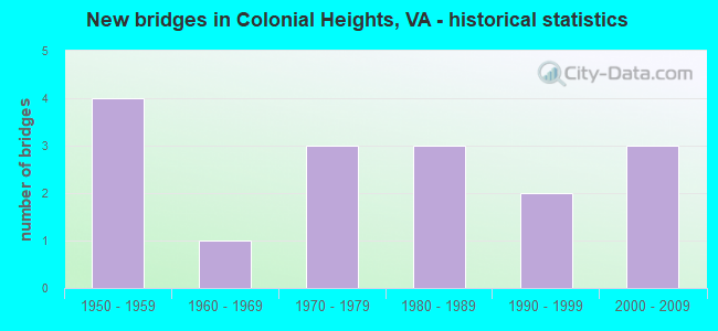
- New bridges - historical statistics
- 41950-1959
- 11960-1969
- 31970-1979
- 31980-1989
- 21990-1999
- 32000-2009
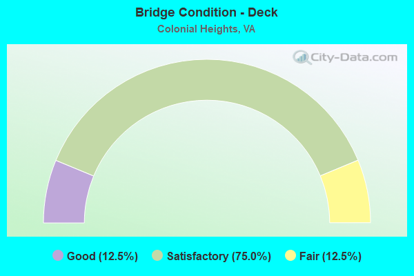
- Bridge Condition - Deck
- 12.5%Good
- 75.0%Satisfactory
- 12.5%Fair
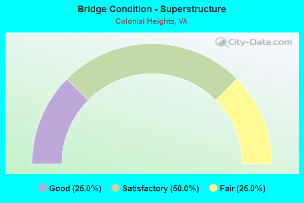
- Bridge Condition - Superstructure
- 25.0%Good
- 50.0%Satisfactory
- 25.0%Fair
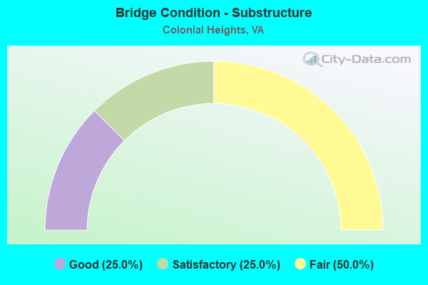
- Bridge Condition - Substructure
- 25.0%Good
- 25.0%Satisfactory
- 50.0%Fair
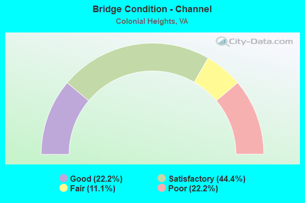
- Bridge Condition - Channel
- 22.2%Good
- 44.4%Satisfactory
- 11.1%Fair
- 22.2%Poor
Find on map >> Show street view
Structure Number: 499, Location: 1.68 FR 144 & .14 TO 1129 (Lat: 37.282892, Lng: -77.412311), Route carried "on" structure: US 1, Year Built: 1990, Status: Open, Structure Length: 5.56m (18.24ft), Average Daily Traffic: 21,131 (year 2020), Truck Traffic: 1%, Average Future Daily Traffic: 21,880 (year 2040), Design Load: HS 20+Mod, Features Intersected: SWIFT CREEK, Facility Carried by Structure: JEFFERSON DAVIS HY
Minimum Vertical Clearance: 30+ m (98+ ft), Kilometerpoint: 120.424, Lanes on structure: 5, Base Highway Network: Yes, Owner: State Highway Agency, Approaching Roadway Width: 20.1m (65.9ft), Skew: 2 degrees, Material/Design: Prestressed concrete, Design/Construction: Stringer/Multi-beam, Number Of Spans In Main Unit: 3, Length of Maximum Span: 17.9m (58.7ft), Curb or Sidewalk Widths: Left: 2.3m (7.5ft), Right: 2.3m (7.5ft), Curb-To-Curb Width: 20.1m (65.9ft), Out-to-Out Width: 25.3m (83.0ft)
Condition: Deck: Satisfactory, Superstructure: Satisfactory, Substructure: Satisfactory, Channel: Satisfactory, Operating Rating: 82.6 metric tons, Method Used To Determine Operating Rating: Load and Resistance Factor (LRFR), Inventory Rating: 63.5 metric tons, Method Used To Determine Inventory Rating: Load and Resistance Factor (LRFR), Structural Evaluation: Equal to present minimum criteria, Deck Geometry: Somewhat better than minimum adequacy, Waterway Adequacy: Equal to present desirable criteria, Approach Roadway Alignment: Equal to present desirable criteria, Designated Inspection Frequency: Every 24 months, Inspection Date: September 2021, Deck Structure Type: Concrete Cast-file-Place, Wearing Surface/Protective System: Deck Protection: Epoxy Coated Reinforcing
Find on map >> Show street view
Structure Number: 5099, Location: 2.05 FR 144 & 1.57 TO 746 (Lat: 37.287125, Lng: -77.389100), Route carried "on" structure: Interstate 95, Year Built: 1958, Status: Open, Structure Length: 7.68m (25.20ft), Average Daily Traffic: 94,989 (year 2020), Truck Traffic: 10%, Average Future Daily Traffic: 132,985 (year 2040), Design Load: HS 20, Features Intersected: SWIFT CREEK
Minimum Vertical Clearance: 30+ m (98+ ft), Kilometerpoint: 91.005, Lanes on structure: 6, Base Highway Network: Yes, Owner: State Highway Agency, Approaching Roadway Width: 36.0m (118.1ft), Skew: 30 degrees, Material/Design: Steel, Design/Construction: Stringer/Multi-beam, Number Of Spans In Main Unit: 4, Length of Maximum Span: 18.6m (61.0ft), Curb-To-Curb Width: 36.0m (118.1ft), Out-to-Out Width: 37.8m (124.0ft)
Condition: Deck: Satisfactory, Superstructure: Fair, Substructure: Fair, Channel: Satisfactory, Operating Rating: 49.0 metric tons, Method Used To Determine Operating Rating: Load and Resistance Factor (LRFR), Inventory Rating: 38.1 metric tons, Method Used To Determine Inventory Rating: Load and Resistance Factor (LRFR), Structural Evaluation: Somewhat better than minimum adequacy, Deck Geometry: Superior to present desirable criteria, Waterway Adequacy: Equal to present minimum criteria, Approach Roadway Alignment: Equal to present desirable criteria, Length Of Structure Improvement: 7.68m (25.20ft), Designated Inspection Frequency: Every 24 months, Underwater Inspection Frequency: Every 60 months, Inspection Date: September 2021, Underwater Inspection Date: April 2021, Bridge Improvement Cost: $3,515,000, Roadway Improvement Cost: $703,000, Total Project Cost: $4,223,000, Deck Structure Type: Concrete Cast-file-Place, Wearing Surface/Protective System: Deck Protection: Epoxy Coated Reinforcing
Find on map >> Show street view
Structure Number: 5259, Location: .56 FR 626 & 4.63 TO 619 (Lat: 37.275711, Lng: -77.432300), Route carried "on" structure: County highway 625, Year Built: 1966, Status: Open, Structure Length: 5.57m (18.27ft), Average Daily Traffic: 2,381 (year 2020), Truck Traffic: 2%, Average Future Daily Traffic: 3,333 (year 2040), Design Load: HS 20+Mod, Features Intersected: SWIFT CREEK, Facility Carried by Structure: BRANDERS BRIDGE RD
Minimum Vertical Clearance: 30+ m (98+ ft), Kilometerpoint: 2.729, Lanes on structure: 2, Owner: State Highway Agency, Approaching Roadway Width: 8.1m (26.6ft), Material/Design: Concrete, Design/Construction: Tee Beam, Number Of Spans In Main Unit: 4, Length of Maximum Span: 13.1m (43.0ft), Curb or Sidewalk Widths: Left: 0.2m (0.7ft), Right: 0.2m (0.7ft), Curb-To-Curb Width: 8.1m (26.6ft), Out-to-Out Width: 9.1m (29.9ft)
Condition: Deck: Satisfactory, Superstructure: Satisfactory, Substructure: Satisfactory, Channel: Fair, Operating Rating: 62.6 metric tons, Method Used To Determine Operating Rating: Load and Resistance Factor (LRFR), Inventory Rating: 48.3 metric tons, Method Used To Determine Inventory Rating: Load and Resistance Factor (LRFR), Structural Evaluation: Equal to present minimum criteria, Deck Geometry: High priority of corrective action, Waterway Adequacy: Equal to present desirable criteria, Approach Roadway Alignment: Equal to present desirable criteria, Length Of Structure Improvement: 5.58m (18.31ft), Designated Inspection Frequency: Every 24 months, Underwater Inspection Frequency: Every 60 months, Inspection Date: June 2021, Underwater Inspection Date: April 2019, Bridge Improvement Cost: $172,000, Roadway Improvement Cost: $90,000, Total Project Cost: $314,000, Deck Structure Type: Concrete Cast-file-Place
Find on map >> Show street view
Structure Number: 14058, Location: 0.0 PR GEO CO 0.0 CHES CO (Lat: 37.252511, Lng: -77.376725), Route carried "on" structure: State highway 144, Year Built: 1986, Status: Open, Structure Length: 30.94m (101.51ft), Average Daily Traffic: 15,183 (year 2020), Truck Traffic: 1%, Average Future Daily Traffic: 21,258 (year 2040), Design Load: HS 20+Mod, Features Intersected: APPOMATTOX RIVER, Facility Carried by Structure: SBL TEMPLE AVENUE
Minimum Vertical Clearance: 30+ m (98+ ft), Kilometerpoint: 4.151, Lanes on structure: 2, Base Highway Network: Yes, Owner: State Highway Agency, Approaching Roadway Width: 12.2m (40.0ft), Skew: 1 degrees, Navigation Control: Yes ( Vertical Clearance: 12.1m (39.7ft), Horizontal Clearance: 24.3m (79.7ft)), Material/Design: Steel, Design/Construction: Stringer/Multi-beam, Number Of Spans In Main Unit: 1, Number Of Approach Spans: 13, Length of Maximum Span: 31.7m (104.0ft), Curb-To-Curb Width: 11.7m (38.4ft), Out-to-Out Width: 12.7m (41.7ft)
Condition: Deck: Satisfactory, Superstructure: Satisfactory, Substructure: Fair, Channel: Poor, Operating Rating: 57.7 metric tons, Method Used To Determine Operating Rating: Load and Resistance Factor (LRFR), Inventory Rating: 44.5 metric tons, Method Used To Determine Inventory Rating: Load and Resistance Factor (LRFR), Structural Evaluation: Somewhat better than minimum adequacy, Deck Geometry: Better than present minimum criteria, Waterway Adequacy: Equal to present desirable criteria, Approach Roadway Alignment: Equal to present desirable criteria, Designated Inspection Frequency: Every 24 months, Underwater Inspection Frequency: Every 60 months, Inspection Date: June 2020, Underwater Inspection Date: June 2020, Deck Structure Type: Concrete Precast Panels, Wearing Surface/Protective System: Deck Protection: Epoxy Coated Reinforcing
Find on map >> Show street view
Structure Number: 14059, Location: 0.0 PR GEO CO 0.0 CHES CO (Lat: 37.252697, Lng: -77.376764), Route carried "on" structure: State highway 144, Year Built: 1987, Status: Open, Structure Length: 30.94m (101.51ft), Average Daily Traffic: 15,183 (year 2020), Truck Traffic: 1%, Average Future Daily Traffic: 21,258 (year 2040), Design Load: HS 20+Mod, Features Intersected: APPOMATTOX RIVER, Facility Carried by Structure: NBL TEMPLE AVENUE
Minimum Vertical Clearance: 30+ m (98+ ft), Kilometerpoint: 4.151, Lanes on structure: 2, Base Highway Network: Yes, Owner: State Highway Agency, Approaching Roadway Width: 12.2m (40.0ft), Skew: 1 degrees, Navigation Control: Yes ( Vertical Clearance: 12.1m (39.7ft), Horizontal Clearance: 24.3m (79.7ft)), Material/Design: Steel, Design/Construction: Stringer/Multi-beam, Number Of Spans In Main Unit: 1, Number Of Approach Spans: 13, Length of Maximum Span: 31.7m (104.0ft), Curb-To-Curb Width: 11.7m (38.4ft), Out-to-Out Width: 12.7m (41.7ft)
Condition: Deck: Satisfactory, Superstructure: Satisfactory, Substructure: Fair, Channel: Poor, Operating Rating: 87.1 metric tons, Method Used To Determine Operating Rating: Load and Resistance Factor (LRFR), Inventory Rating: 67.1 metric tons, Method Used To Determine Inventory Rating: Load and Resistance Factor (LRFR), Structural Evaluation: Somewhat better than minimum adequacy, Deck Geometry: Better than present minimum criteria, Waterway Adequacy: Equal to present desirable criteria, Approach Roadway Alignment: Equal to present desirable criteria, Designated Inspection Frequency: Every 24 months, Underwater Inspection Frequency: Every 48 months, Inspection Date: June 2020, Underwater Inspection Date: June 2020, Deck Structure Type: Concrete Precast Panels, Wearing Surface/Protective System: Deck Protection: Epoxy Coated Reinforcing
Find on map >> Show street view
Structure Number: 20135, Location: .45 FR 144 .29 TO LAKEVIE (Lat: 37.264767, Lng: -77.411700), Route carried "on" structure: US 1, Year Built: 1987, Status: Open, Structure Length: 0.67m (2.20ft), Average Daily Traffic: 18,380 (year 2020), Truck Traffic: 1%, Average Future Daily Traffic: 20,218 (year 2040), Design Load: HS 20+Mod, Features Intersected: OLD TOWN CREEK, Facility Carried by Structure: BOULEVARD
Minimum Vertical Clearance: 30+ m (98+ ft), Kilometerpoint: 118.390, Lanes on structure: 4, Base Highway Network: Yes, Owner: City or Municipal Highway Agency, Approaching Roadway Width: 19.5m (64.0ft), Material/Design: Concrete, Design/Construction: Slab, Number Of Spans In Main Unit: 1, Length of Maximum Span: 6.7m (22.0ft), Curb or Sidewalk Widths: Left: 0.2m (0.7ft), Right: 2.3m (7.5ft), Curb-To-Curb Width: 32.0m (105.0ft), Out-to-Out Width: 35.1m (115.2ft)
Condition: Deck: Fair, Superstructure: Fair, Substructure: Fair, Channel: Good, Operating Rating: 91.2 metric tons, Method Used To Determine Operating Rating: Load and Resistance Factor (LRFR), Inventory Rating: 70.3 metric tons, Method Used To Determine Inventory Rating: Load and Resistance Factor (LRFR), Structural Evaluation: Somewhat better than minimum adequacy, Deck Geometry: Superior to present desirable criteria, Waterway Adequacy: Equal to present minimum criteria, Approach Roadway Alignment: Equal to present desirable criteria, Designated Inspection Frequency: Every 24 months, Inspection Date: November 2020, Deck Structure Type: Concrete Cast-file-Place, Wearing Surface/Protective System: Wearing Surface: Monolithic Concrete, Deck Protection: Epoxy Coated Reinforcing
Find on map >> Show street view
Structure Number: 23568, Location: .05 144(TMPL) .33 CHARLES (Lat: 37.258303, Lng: -77.395917), Route carried "on" structure: City street , Year Built: 1992, Status: Open, Structure Length: 2.35m (7.71ft), Average Daily Traffic: 16,934 (year 2020), Truck Traffic: 1%, Average Future Daily Traffic: 18,627 (year 2040), Design Load: HS 20+Mod, Features Intersected: OLD TOWN CREEK, Facility Carried by Structure: CONDUIT ROAD
Minimum Vertical Clearance: 30+ m (98+ ft), Kilometerpoint: 2.414, Lanes on structure: 7, Owner: City or Municipal Highway Agency, Approaching Roadway Width: 26.8m (87.9ft), Skew: 31 degrees, Material/Design: Concrete, Design/Construction: Culvert, Number Of Spans In Main Unit: 6, Length of Maximum Span: 3.7m (12.1ft)
Condition: Channel: Satisfactory, Culverts: Satisfactory, Operating Rating: 63.3 metric tons, Method Used To Determine Operating Rating: Load and Resistance Factor (LRFR), Inventory Rating: 48.9 metric tons, Method Used To Determine Inventory Rating: Load and Resistance Factor (LRFR), Structural Evaluation: Equal to present minimum criteria, Waterway Adequacy: Equal to present desirable criteria, Approach Roadway Alignment: Equal to present desirable criteria, Designated Inspection Frequency: Every 24 months, Inspection Date: December 2020
Find on map >> Show street view
Structure Number: 27432, Location: 0.21 FR 1 & 0.20 TO OLDTN (Lat: 37.269919, Lng: -77.408419), Route carried "on" structure: City street , Year Built: 2000, Status: Open, Structure Length: 5.18m (16.99ft), Average Daily Traffic: 12,373 (year 2020), Truck Traffic: 1%, Average Future Daily Traffic: 13,882 (year 2040), Design Load: HS 20+Mod, Features Intersected: CSX RAILWAY, Facility Carried by Structure: ELLERSLIE AVENUE
Minimum Vertical Clearance: 30+ m (98+ ft), Kilometerpoint: 0.338, Lanes on structure: 4, Owner: City or Municipal Highway Agency, Approaching Roadway Width: 18.3m (60.0ft), Skew: 1 degrees, Material/Design: Steel continuous, Design/Construction: Stringer/Multi-beam, Number Of Spans In Main Unit: 3, Length of Maximum Span: 23.2m (76.1ft), Curb or Sidewalk Widths: Left: 2.4m (7.9ft), Right: 2.4m (7.9ft), Curb-To-Curb Width: 18.3m (60.0ft), Out-to-Out Width: 23.9m (78.4ft)
Condition: Deck: Satisfactory, Superstructure: Good, Substructure: Good, Operating Rating: 41.5 metric tons, Method Used To Determine Operating Rating: Load and Resistance Factor (LRFR), Inventory Rating: 32.0 metric tons, Method Used To Determine Inventory Rating: Load and Resistance Factor (LRFR), Structural Evaluation: Better than present minimum criteria, Deck Geometry: Somewhat better than minimum adequacy, Underclear: Equal to present minimum criteria, Approach Roadway Alignment: Equal to present desirable criteria, Designated Inspection Frequency: Every 24 months, Inspection Date: November 2020, Deck Structure Type: Concrete Cast-file-Place, Wearing Surface/Protective System: Wearing Surface: Monolithic Concrete, Deck Protection: Epoxy Coated Reinforcing
Find on map >> Show street view
Structure Number: 27849, Location: .10 FR 144 NB .20 TO 95 N (Lat: 37.259050, Lng: -77.398383), Route carried "on" structure: Ramp State highway 144, Year Built: 2008, Status: Open, Structure Length: 3.75m (12.30ft), Average Daily Traffic: 16,500 (year 2019), Truck Traffic: 1%, Average Future Daily Traffic: 1,800 (year 2027), Design Load: HS 20+Mod, Features Intersected: OLD TOWN CREEK
Minimum Vertical Clearance: 30+ m (98+ ft), Kilometerpoint: 0.000, Lanes on structure: 1, Base Highway Network: Yes, Owner: State Highway Agency, Approaching Roadway Width: 9.1m (29.9ft), Skew: 4 degrees, Material/Design: Prestressed concrete, Design/Construction: Stringer/Multi-beam, Number Of Spans In Main Unit: 1, Length of Maximum Span: 35.4m (116.1ft), Curb-To-Curb Width: 9.9m (32.5ft), Out-to-Out Width: 10.9m (35.8ft)
Condition: Deck: Good, Superstructure: Good, Substructure: Good, Channel: Satisfactory, Operating Rating: 99.8 metric tons, Method Used To Determine Operating Rating: Load and Resistance Factor (LRFR), Inventory Rating: 60.8 metric tons, Method Used To Determine Inventory Rating: Load and Resistance Factor (LRFR), Structural Evaluation: Better than present minimum criteria, Deck Geometry: Superior to present desirable criteria, Waterway Adequacy: Equal to present desirable criteria, Approach Roadway Alignment: Equal to present desirable criteria, Designated Inspection Frequency: Every 24 months, Inspection Date: August 2020, Deck Structure Type: Concrete Cast-file-Place, Wearing Surface/Protective System: Deck Protection: Epoxy Coated Reinforcing
Find on map >> Show street view
Structure Number: 30207, Location: 0.05 FR Dd end&.1 to 931 (Lat: 37.306111, Lng: -77.374444), Route carried "on" structure: County highway 7701, Year Built: 2009, Status: Open, Structure Length: 0.67m (2.20ft), Average Daily Traffic: 40 (year 2020), Average Future Daily Traffic: 50 (year 2034), Design Load: HS 20+Mod, Features Intersected: UNNAMED TRIBUTARY, Facility Carried by Structure: SABRA WAY
Minimum Vertical Clearance: 30+ m (98+ ft), Kilometerpoint: 0.000, Lanes on structure: 2, Owner: State Highway Agency, Approaching Roadway Width: 7.0m (23.0ft), Material/Design: Concrete, Design/Construction: Culvert, Number Of Spans In Main Unit: 3, Length of Maximum Span: 1.7m (5.6ft)
Condition: Channel: Good, Culverts: Satisfactory, Operating Rating: 54.4 metric tons, Method Used To Determine Operating Rating: Field evaluation and documented engineering judgment, Inventory Rating: 32.7 metric tons, Method Used To Determine Inventory Rating: Field evaluation and documented engineering judgment, Structural Evaluation: Equal to present minimum criteria, Waterway Adequacy: Equal to present desirable criteria, Approach Roadway Alignment: Equal to present desirable criteria, Designated Inspection Frequency: Every 24 months, Inspection Date: May 2021
Find on map >> Show street view
Structure Number: 20124, Location: .05Roslyne(W).05Roslyne(E (Lat: 37.243067, Lng: -77.394708), Route carried "under" structure: Interstate 95, Year Built: 1976, Structure Length: 0. m, Average Daily Traffic: 109,000 (year 2018), Truck Traffic: 8%, Features Intersected: ROUTE I-95, Facility Carried by Structure: SOUTHPARK BLVD
Minimum Vertical Clearance: 4.90m (16.08ft), Kilometerpoint: 85.760, Lanes on structure: 2, Lanes under structure: 8, Material/Design: Steel continuous, Design/Construction: Stringer/Multi-beam, Length of Maximum Span: 30.9m (101.4ft)
Find on map >> Show street view
Structure Number: 20126, Location: .10 W ROSLYN RD & .25 144 (Lat: 37.254106, Lng: -77.397294), Route carried "under" structure: Interstate 95, Year Built: 1977, Structure Length: 0. m, Average Daily Traffic: 88,606 (year 2008), Truck Traffic: 4%, Features Intersected: ROUTE I-95, Facility Carried by Structure: CONDUIT ROAD
Minimum Vertical Clearance: 4.70m (15.42ft), Kilometerpoint: 87.143, Lanes on structure: 4, Lanes under structure: 8, Material/Design: Steel continuous, Design/Construction: Stringer/Multi-beam, Length of Maximum Span: 46.0m (150.9ft)
Find on map >> Show street view
Structure Number: 20128, Location: .19 COMPN DR .10 HOLLY AV (Lat: 37.265181, Lng: -77.397289), Route carried "under" structure: Interstate 95, Year Built: 1977, Structure Length: 0. m, Average Daily Traffic: 91,961 (year 2008), Truck Traffic: 4%, Features Intersected: ROUTE I-95, Facility Carried by Structure: ELLERSLIE AVENUE
Minimum Vertical Clearance: 4.65m (15.26ft), Kilometerpoint: 88.398, Lanes on structure: 3, Lanes under structure: 6, Material/Design: Steel continuous, Design/Construction: Stringer/Multi-beam, Length of Maximum Span: 28.3m (92.8ft)
Find on map >> Show street view
Structure Number: 20137, Location: 1.37 NCL Ptrbr 2.2 Chstrf (Lat: 37.257450, Lng: -77.398761), Route carried "under" structure: Ramp Interstate 95, Year Built: 1958, Structure Length: 0. m, Average Daily Traffic: 5,000 (year 1994), Features Intersected: RTE 95 RMP A FOR RTE 144
Minimum Vertical Clearance: 4.62m (15.16ft), Kilometerpoint: 0.000, Lanes on structure: 6, Lanes under structure: 2, Material/Design: Steel, Design/Construction: Stringer/Multi-beam, Length of Maximum Span: 16.5m (54.1ft)
Find on map >> Show street view
Structure Number: 20139, Location: 1.5 NCL PETBG 2.06 CHESFD (Lat: 37.258950, Lng: -77.399078), Route carried "under" structure: State highway 144, Year Built: 1958, Structure Length: 0. m, Average Daily Traffic: 33,000 (year 2018), Features Intersected: RTE 144 & OLD TOWN CREEK, Facility Carried by Structure: ROUTE 0095
Minimum Vertical Clearance: 5.61m (18.41ft), Kilometerpoint: 6.275, Lanes on structure: 8, Lanes under structure: 4, Material/Design: Steel, Design/Construction: Stringer/Multi-beam, Length of Maximum Span: 23.5m (77.1ft)
Find on map >> Show street view
Structure Number: 20143, Location: 0.30TEMPLE AV .02 95NBL (Lat: 37.257489, Lng: -77.398569), Route carried "under" structure: Ramp Interstate 95, Year Built: 1958, Structure Length: 0. m, Average Daily Traffic: 9,200 (year 2018), Truck Traffic: 2%, Features Intersected: RTE 95 RMP A FOR RTE 144
Minimum Vertical Clearance: 4.50m (14.76ft), Kilometerpoint: 0.000, Lanes on structure: 1, Lanes under structure: 2, Material/Design: Steel, Design/Construction: Stringer/Multi-beam, Length of Maximum Span: 15.8m (51.8ft)