Bridge Statistics for Colon, Michigan (MI)
Condition, Traffic, Stress, Structural Evaluation, Project Costs
- National Bridge Inventory (NBI) Statistics
- 11Number of bridges
- 98ft / 30.5mTotal length
- $451,000Total costs
- 10,650Total average daily traffic
- 449Total average daily truck traffic
- 18,601Total future (year 2023) average daily traffic
- National Bridge Inventory (NBI) Registered Bridges for Colon
- No street view available for this location
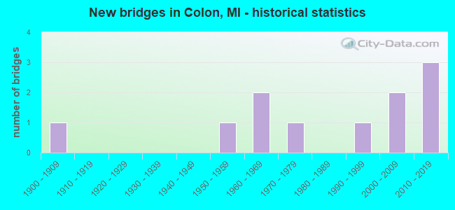
- New bridges - historical statistics
- 11900-1909
- 11950-1959
- 21960-1969
- 11970-1979
- 11990-1999
- 22000-2009
- 32010-2019


- Bridge Condition - Deck
- 18.2%Very good
- 45.5%Good
- 27.3%Satisfactory
- 9.1%Fair

- Bridge Condition - Superstructure
- 36.4%Very good
- 18.2%Good
- 18.2%Satisfactory
- 18.2%Fair
- 9.1%Poor

- Bridge Condition - Substructure
- 45.5%Very good
- 18.2%Good
- 9.1%Satisfactory
- 9.1%Fair
- 18.2%Poor

- Bridge Condition - Channel
- 18.2%Very good
- 18.2%Good
- 18.2%Satisfactory
- 45.5%Fair
Find on map >> Show street view
Structure Number: 1037, Location: 4 MI NW OF GALIEN (Lat: 41.827325, Lng: -86.550550), Route carried "on" structure: County highway , Year Built: 2015, Status: Open, Structure Length: 1.95m (6.40ft), Average Daily Traffic: 200 (year 2015), Truck Traffic: 3%, Average Future Daily Traffic: 400 (year 2035), Design Load: Greater than HL93, Features Intersected: DOWLING CREEK, Facility Carried by Structure: ELM VALLEY ROAD
Minimum Vertical Clearance: 30.48m (100.00ft), Kilometerpoint: 12.922, Lanes on structure: 2, Owner: County Highway Agency, Approaching Roadway Width: 9.8m (32.2ft), Skew: 2 degrees, Material/Design: Prestressed concrete, Design/Construction: Box Beam or Girders - Multiple, Number Of Spans In Main Unit: 1, Length of Maximum Span: 19.1m (62.7ft), Curb-To-Curb Width: 9.8m (32.2ft), Out-to-Out Width: 10.5m (34.4ft)
Condition: Deck: Very good, Superstructure: Very good, Substructure: Very good, Channel: Very good, Operating Rating: 67.1 metric tons, Method Used To Determine Operating Rating: Load and Resistance Factor Rating (LRFR) rating reported by rating factor(RF) method using HL-93 loadings, Inventory Rating: 51.8 metric tons, Method Used To Determine Inventory Rating: Load and Resistance Factor Rating (LRFR) rating reported by rating factor(RF) method using HL-93 loadings, Structural Evaluation: Equal to present desirable criteria, Deck Geometry: Better than present minimum criteria, Waterway Adequacy: Better than present minimum criteria, Approach Roadway Alignment: Equal to present desirable criteria, Designated Inspection Frequency: Every 24 months, Inspection Date: April 2020, Deck Structure Type: Concrete Cast-file-Place, Wearing Surface/Protective System: Wearing Surface: Monolithic Concrete, Deck Protection: Epoxy Coated Reinforcing
Find on map >> Show street view
Structure Number: 117, Location: MATTESON TWP SEC 29 (Lat: 41.924239, Lng: -85.263469), Route carried "on" structure: County highway , Year Built: 1996, Status: Open, Structure Length: 1.82m (5.97ft), Average Daily Traffic: 211 (year 2004), Truck Traffic: 4%, Average Future Daily Traffic: 329 (year 2024), Design Load: H 20, Features Intersected: LITTLE SWAN CREEK DRAIN, Facility Carried by Structure: LYTER ROAD
Minimum Vertical Clearance: 30.48m (100.00ft), Kilometerpoint: 3.330, Lanes on structure: 2, Owner: County Highway Agency, Approaching Roadway Width: 9.1m (29.9ft), Skew: 3 degrees, Material/Design: Prestressed concrete, Design/Construction: Box Beam or Girders - Multiple, Number Of Spans In Main Unit: 1, Length of Maximum Span: 17.0m (55.8ft), Curb-To-Curb Width: 9.1m (29.9ft), Out-to-Out Width: 9.4m (30.8ft)
Condition: Deck: Good, Superstructure: Good, Substructure: Very good, Channel: Good, Operating Rating: 80.7 metric tons, Method Used To Determine Operating Rating: Load Factor (LF), Inventory Rating: 48.4 metric tons, Method Used To Determine Inventory Rating: Load Factor (LF), Structural Evaluation: Better than present minimum criteria, Deck Geometry: Equal to present minimum criteria, Waterway Adequacy: Equal to present desirable criteria, Approach Roadway Alignment: Equal to present desirable criteria, Designated Inspection Frequency: Every 24 months, Inspection Date: October 2020, Deck Structure Type: Concrete Precast Panels, Wearing Surface/Protective System: Wearing Surface: Bituminous, Membrane: Preformed Fabric
Find on map >> Show street view
Structure Number: 10285, Location: IN COLON (Lat: 41.958403, Lng: -85.323333), Route carried "on" structure: State highway 86, Year Built: 2008, Status: Open, Structure Length: 2.58m (8.46ft), Average Daily Traffic: 4,063 (year 2007), Truck Traffic: 3%, Average Future Daily Traffic: 9,200 (year 2025), Design Load: HL 93, Features Intersected: SWAN CREEK
Minimum Vertical Clearance: 30.48m (100.00ft), Kilometerpoint: 7.925, Lanes on structure: 3, Owner: State Highway Agency, Approaching Roadway Width: 12.2m (40.0ft), Material/Design: Prestressed concrete, Design/Construction: Box Beam or Girders - Single/Spread, Number Of Spans In Main Unit: 1, Length of Maximum Span: 25.8m (84.6ft), Curb or Sidewalk Widths: Left: 1.9m (6.2ft), Right: 1.9m (6.2ft), Curb-To-Curb Width: 12.2m (40.0ft), Out-to-Out Width: 16.9m (55.4ft)
Condition: Deck: Good, Superstructure: Satisfactory, Substructure: Good, Channel: Fair, Operating Rating: 66.4 metric tons, Method Used To Determine Operating Rating: Load Factor (LF) rating reported by rating factor (RF) method using MS18 loading, Inventory Rating: 22.4 metric tons, Method Used To Determine Inventory Rating: Load Factor (LF) rating reported by rating factor (RF) method using MS18 loading, Structural Evaluation: Somewhat better than minimum adequacy, Deck Geometry: Meets minimum limits, Waterway Adequacy: Equal to present desirable criteria, Approach Roadway Alignment: Equal to present desirable criteria, Designated Inspection Frequency: Every 24 months, Inspection Date: September 2021, Deck Structure Type: Concrete Cast-file-Place, Wearing Surface/Protective System: Wearing Surface: Monolithic Concrete, Deck Protection: Epoxy Coated Reinforcing
Find on map >> Show street view
Structure Number: 10296, Location: EAST OF COLON (Lat: 41.964400, Lng: -85.305994), Route carried "on" structure: County highway 7862, Year Built: 1950, Status: Open, Structure Length: 0.91m (2.99ft), Average Daily Traffic: 2,222 (year 2003), Truck Traffic: 5%, Average Future Daily Traffic: 3,224 (year 2023), Features Intersected: BEAR CREEK, Facility Carried by Structure: WATTLES RD OLD M78
Minimum Vertical Clearance: 30.48m (100.00ft), Kilometerpoint: 0.584, Lanes on structure: 2, Owner: County Highway Agency, Approaching Roadway Width: 10.1m (33.1ft), Material/Design: Steel, Design/Construction: Stringer/Multi-beam, Number Of Spans In Main Unit: 1, Length of Maximum Span: 9.1m (29.9ft), Curb or Sidewalk Widths: Left: 0.4m (1.3ft), Right: 0.4m (1.3ft), Curb-To-Curb Width: 9.1m (29.9ft), Out-to-Out Width: 9.7m (31.8ft)
Condition: Deck: Satisfactory, Superstructure: Poor, Substructure: Good, Channel: Fair, Operating Rating: 58.3 metric tons, Method Used To Determine Operating Rating: Load Factor (LF) rating reported by rating factor (RF) method using MS18 loading, Inventory Rating: 35.0 metric tons, Method Used To Determine Inventory Rating: Load Factor (LF) rating reported by rating factor (RF) method using MS18 loading, Structural Evaluation: Meets minimum limits, Deck Geometry: Meets minimum limits, Waterway Adequacy: Better than present minimum criteria, Approach Roadway Alignment: Equal to present minimum criteria, Designated Inspection Frequency: Every 24 months, Inspection Date: November 2021, Deck Structure Type: Concrete Cast-file-Place, Wearing Surface/Protective System: Wearing Surface: Bituminous
Find on map >> Show street view
Structure Number: 10321, Location: 3 MI SOUTH OF COLON (Lat: 41.921194, Lng: -85.311942), Route carried "on" structure: County highway 7883, Year Built: 1963, Status: Posted for load, Structure Length: 0.79m (2.59ft), Average Daily Traffic: 933 (year 2003), Truck Traffic: 5%, Average Future Daily Traffic: 1,293 (year 2023), Design Load: HS 20, Features Intersected: LITTLE SWAN CREEK, Facility Carried by Structure: NORTH BURR OAK RD
Minimum Vertical Clearance: 30.48m (100.00ft), Kilometerpoint: 11.861, Lanes on structure: 2, Owner: County Highway Agency, Approaching Roadway Width: 9.1m (29.9ft), Material/Design: Wood or Timber, Design/Construction: Slab, Number Of Spans In Main Unit: 1, Length of Maximum Span: 7.9m (25.9ft), Curb-To-Curb Width: 8.8m (28.9ft), Out-to-Out Width: 9.0m (29.5ft)
Condition: Deck: Satisfactory, Superstructure: Satisfactory, Substructure: Poor, Channel: Satisfactory, Operating Rating: 36.4 metric tons, Method Used To Determine Operating Rating: Allowable Stress (AS), Inventory Rating: 24.0 metric tons, Method Used To Determine Inventory Rating: Allowable Stress (AS), Structural Evaluation: Meets minimum limits, Deck Geometry: Somewhat better than minimum adequacy, Waterway Adequacy: Better than present minimum criteria, Approach Roadway Alignment: Equal to present minimum criteria, Bridge Posting: Required (Relationship of Operating Rating to Maximum Legal Load: 20.0 - 29.9% below), Designated Inspection Frequency: Every 12 months, Inspection Date: November 2021, Deck Structure Type: Wood or Timber, Wearing Surface/Protective System: Wearing Surface: Bituminous
Find on map >> Show street view
Structure Number: 10322, Location: 4 MI EAST OF MENDON (Lat: 41.997664, Lng: -85.375769), Route carried "on" structure: County highway , Year Built: 1972, Status: Posted for load, Structure Length: 5.30m (17.39ft), Average Daily Traffic: 533 (year 2003), Truck Traffic: 5%, Average Future Daily Traffic: 706 (year 2023), Design Load: HS 20, Features Intersected: ST JOSEPH RIVER, Facility Carried by Structure: BENNETT ROAD
Minimum Vertical Clearance: 30.48m (100.00ft), Kilometerpoint: 2.250, Lanes on structure: 2, Owner: County Highway Agency, Approaching Roadway Width: 10.1m (33.1ft), Material/Design: Prestressed concrete, Design/Construction: Box Beam or Girders - Multiple, Number Of Spans In Main Unit: 3, Length of Maximum Span: 17.6m (57.7ft), Curb-To-Curb Width: 9.1m (29.9ft), Out-to-Out Width: 9.2m (30.2ft)
Condition: Deck: Satisfactory, Superstructure: Fair, Substructure: Satisfactory, Channel: Fair, Operating Rating: 40.8 metric tons, Method Used To Determine Operating Rating: Load Factor (LF) rating reported by rating factor (RF) method using MS18 loading, Inventory Rating: 24.3 metric tons, Method Used To Determine Inventory Rating: Load Factor (LF) rating reported by rating factor (RF) method using MS18 loading, Structural Evaluation: Somewhat better than minimum adequacy, Deck Geometry: Equal to present minimum criteria, Waterway Adequacy: Better than present minimum criteria, Approach Roadway Alignment: Somewhat better than minimum adequacy, Bridge Posting: Required (Relationship of Operating Rating to Maximum Legal Load: 20.0 - 29.9% below), Designated Inspection Frequency: Every 24 months, Inspection Date: November 2021, Deck Structure Type: Concrete Precast Panels, Wearing Surface/Protective System: Wearing Surface: Bituminous
Find on map >> Show street view
Structure Number: 10324, Location: 1.0 MI NW OF COLON (Lat: 41.981825, Lng: -85.334083), Route carried "on" structure: County highway 7887, Year Built: 1965, Status: Posted for load, Structure Length: 9.51m (31.20ft), Average Daily Traffic: 1,111 (year 2003), Truck Traffic: 5%, Average Future Daily Traffic: 1,485 (year 2023), Design Load: HS 20, Features Intersected: ST JOSEPH RIVER, Facility Carried by Structure: FARRAND ROAD
Minimum Vertical Clearance: 30.48m (100.00ft), Kilometerpoint: 9.949, Lanes on structure: 2, Owner: County Highway Agency, Approaching Roadway Width: 10.1m (33.1ft), Material/Design: Wood or Timber, Design/Construction: Slab, Number Of Spans In Main Unit: 13, Length of Maximum Span: 7.3m (24.0ft), Curb-To-Curb Width: 9.1m (29.9ft), Out-to-Out Width: 9.6m (31.5ft)
Condition: Deck: Fair, Superstructure: Fair, Substructure: Poor, Channel: Fair, Operating Rating: 27.9 metric tons, Method Used To Determine Operating Rating: Allowable Stress (AS) rating reported by rating factor (RF) method using MS18 loading, Inventory Rating: 19.8 metric tons, Method Used To Determine Inventory Rating: Allowable Stress (AS) rating reported by rating factor (RF) method using MS18 loading, Structural Evaluation: Meets minimum limits, Deck Geometry: Somewhat better than minimum adequacy, Waterway Adequacy: Equal to present minimum criteria, Approach Roadway Alignment: Equal to present minimum criteria, Bridge Posting: Required (Relationship of Operating Rating to Maximum Legal Load: 20.0 - 29.9% below), Designated Inspection Frequency: Every 12 months, Inspection Date: November 2021, Deck Structure Type: Wood or Timber, Wearing Surface/Protective System: Wearing Surface: Bituminous
Find on map >> Show street view
Structure Number: 10325, Location: 1.0 MI NE OF COLON (Lat: 41.972292, Lng: -85.302675), Route carried "on" structure: County highway , Year Built: 2010, Status: Open, Structure Length: 4.47m (14.67ft), Average Daily Traffic: 864 (year 2009), Truck Traffic: 5%, Average Future Daily Traffic: 1,325 (year 2029), Design Load: HL 93, Features Intersected: ST JOSEPH RIVER, Facility Carried by Structure: STOWELL ROAD
Minimum Vertical Clearance: 30.48m (100.00ft), Kilometerpoint: 0.620, Lanes on structure: 2, Owner: County Highway Agency, Approaching Roadway Width: 9.1m (29.9ft), Skew: 1 degrees, Material/Design: Prestressed concrete, Design/Construction: Box Beam or Girders - Multiple, Number Of Spans In Main Unit: 3, Length of Maximum Span: 16.7m (54.8ft), Curb-To-Curb Width: 9.1m (29.9ft), Out-to-Out Width: 10.2m (33.5ft)
Condition: Deck: Good, Superstructure: Good, Substructure: Very good, Channel: Good, Operating Rating: 46.7 metric tons, Method Used To Determine Operating Rating: Load and Resistance Factor Rating (LRFR) rating reported by rating factor(RF) method using HL-93 loadings, Inventory Rating: 36.0 metric tons, Method Used To Determine Inventory Rating: Load and Resistance Factor Rating (LRFR) rating reported by rating factor(RF) method using HL-93 loadings, Structural Evaluation: Better than present minimum criteria, Deck Geometry: Equal to present minimum criteria, Waterway Adequacy: Better than present minimum criteria, Approach Roadway Alignment: Better than present minimum criteria, Designated Inspection Frequency: Every 24 months, Underwater Inspection Frequency: Every 60 months, Inspection Date: November 2021, Underwater Inspection Date: May 2018, Deck Structure Type: Concrete Precast Panels, Wearing Surface/Protective System: Wearing Surface: Bituminous, Membrane: Preformed Fabric
Find on map >> Show street view
Structure Number: 1037, Location: 3 MI S OF COLON (Lat: 41.912158, Lng: -85.307719), Route carried "on" structure: County highway , Year Built: 1909, Year Reconstructed: 1996, Status: Open, Structure Length: 0.91m (2.99ft), Average Daily Traffic: 99 (year 2003), Truck Traffic: 5%, Average Future Daily Traffic: 130 (year 2023), Features Intersected: WASHBURN CREEK, Facility Carried by Structure: HAGELGANS ROAD
Minimum Vertical Clearance: 30.48m (100.00ft), Kilometerpoint: 1.749, Lanes on structure: 2, Owner: County Highway Agency, Approaching Roadway Width: 6.1m (20.0ft), Material/Design: Wood or Timber, Design/Construction: Slab, Number Of Spans In Main Unit: 1, Length of Maximum Span: 8.8m (28.9ft), Curb-To-Curb Width: 6.4m (21.0ft), Out-to-Out Width: 6.9m (22.6ft)
Condition: Deck: Good, Superstructure: Very good, Substructure: Fair, Channel: Fair, Operating Rating: 49.6 metric tons, Method Used To Determine Operating Rating: Allowable Stress (AS), Inventory Rating: 35.2 metric tons, Method Used To Determine Inventory Rating: Allowable Stress (AS), Structural Evaluation: Somewhat better than minimum adequacy, Waterway Adequacy: Equal to present minimum criteria, Approach Roadway Alignment: Equal to present minimum criteria, Designated Inspection Frequency: Every 24 months, Inspection Date: November 2021, Deck Structure Type: Wood or Timber, Wearing Surface/Protective System: Wearing Surface: Bituminous
Find on map >> Show street view
Structure Number: 10371, Location: 3 MI S OF COLON (Lat: 41.919544, Lng: -85.309711), Route carried "on" structure: County highway , Year Built: 2009, Status: Open, Structure Length: 0.85m (2.79ft), Average Daily Traffic: 99 (year 2003), Truck Traffic: 5%, Average Future Daily Traffic: 125 (year 2023), Features Intersected: WASHBURN CREEK, Facility Carried by Structure: CUSTER ROAD
Minimum Vertical Clearance: 30.48m (100.00ft), Kilometerpoint: 1.782, Lanes on structure: 2, Owner: County Highway Agency, Approaching Roadway Width: 7.0m (23.0ft), Material/Design: Wood or Timber, Design/Construction: Slab, Number Of Spans In Main Unit: 1, Length of Maximum Span: 8.2m (26.9ft), Curb or Sidewalk Widths: Left: 0.2m (0.7ft), Right: 0.2m (0.7ft), Curb-To-Curb Width: 8.5m (27.9ft), Out-to-Out Width: 8.8m (28.9ft)
Condition: Deck: Good, Superstructure: Very good, Substructure: Very good, Channel: Satisfactory, Operating Rating: 95.0 metric tons, Method Used To Determine Operating Rating: Allowable Stress (AS), Inventory Rating: 69.0 metric tons, Method Used To Determine Inventory Rating: Allowable Stress (AS), Structural Evaluation: Equal to present desirable criteria, Waterway Adequacy: Better than present minimum criteria, Approach Roadway Alignment: Equal to present desirable criteria, Length Of Structure Improvement: 1.54m (5.05ft), Designated Inspection Frequency: Every 24 months, Inspection Date: November 2021, Bridge Improvement Cost: $131,000, Roadway Improvement Cost: $10,000, Total Project Cost: $241,000, Deck Structure Type: Wood or Timber, Wearing Surface/Protective System: Wearing Surface: Bituminous
Find on map >> Show street view
Structure Number: 10373, Location: 2 MI S OF COLON (Lat: 41.926800, Lng: -85.326622), Route carried "on" structure: County highway , Year Built: 2017, Status: Open, Structure Length: 1.37m (4.49ft), Average Daily Traffic: 315 (year 2016), Truck Traffic: 8%, Average Future Daily Traffic: 384 (year 2036), Design Load: Greater than HL93, Features Intersected: LITTLE SWAN CREEK, Facility Carried by Structure: DECKER ROAD
Minimum Vertical Clearance: 30.48m (100.00ft), Kilometerpoint: 1.693, Lanes on structure: 2, Owner: County Highway Agency, Approaching Roadway Width: 7.9m (25.9ft), Material/Design: Prestressed concrete, Design/Construction: Box Beam or Girders - Multiple, Number Of Spans In Main Unit: 1, Length of Maximum Span: 13.0m (42.7ft), Curb-To-Curb Width: 7.9m (25.9ft), Out-to-Out Width: 8.8m (28.9ft)
Condition: Deck: Very good, Superstructure: Very good, Substructure: Very good, Channel: Very good, Operating Rating: 96.9 metric tons, Method Used To Determine Operating Rating: Load and Resistance Factor Rating (LRFR) rating reported by rating factor(RF) method using HL-93 loadings, Inventory Rating: 74.8 metric tons, Method Used To Determine Inventory Rating: Load and Resistance Factor Rating (LRFR) rating reported by rating factor(RF) method using HL-93 loadings, Structural Evaluation: Equal to present desirable criteria, Deck Geometry: Somewhat better than minimum adequacy, Waterway Adequacy: Equal to present desirable criteria, Approach Roadway Alignment: Equal to present desirable criteria, Length Of Structure Improvement: 2.24m (7.35ft), Designated Inspection Frequency: Every 24 months, Inspection Date: November 2021, Bridge Improvement Cost: $190,000, Roadway Improvement Cost: $20,000, Total Project Cost: $210,000, Deck Structure Type: Concrete Cast-file-Place, Wearing Surface/Protective System: Wearing Surface: Monolithic Concrete, Deck Protection: Epoxy Coated Reinforcing