Bridge Statistics for Colchester, Illinois (IL)
Condition, Traffic, Stress, Structural Evaluation, Project Costs
- National Bridge Inventory (NBI) Statistics
- 12Number of bridges
- 115ft / 34.6mTotal length
- $310,000Total costs
- 6,575Total average daily traffic
- 1,123Total average daily truck traffic
- 6,068Total future (year 2032) average daily traffic
- National Bridge Inventory (NBI) Registered Bridges for Colchester
- No street view available for this location
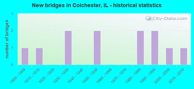
- New bridges - historical statistics
- 11900-1909
- 11910-1919
- 21930-1939
- 21950-1959
- 21980-1989
- 21990-1999
- 12000-2009
- 12010-2019


- Bridge Condition - Deck
- 12.5%Very good
- 75.0%Good
- 12.5%Fair

- Bridge Condition - Superstructure
- 25.0%Very good
- 62.5%Good
- 12.5%Fair

- Bridge Condition - Substructure
- 12.5%Very good
- 50.0%Good
- 25.0%Fair
- 12.5%Poor

- Bridge Condition - Channel
- 8.3%Excellent
- 8.3%Very good
- 41.7%Good
- 8.3%Satisfactory
- 8.3%Fair
- 25.0%Poor

- Bridge Condition - Culverts
- 25.0%Very good
- 50.0%Satisfactory
- 25.0%Fair
Find on map >> Show street view
Structure Number: 550021, Location: 1 MI N COLCHESTER (Lat: 40.442533, Lng: -90.800672), Route carried "on" structure: County highway , Year Built: 1956, Status: Open, Structure Length: 6.22m (20.41ft), Average Daily Traffic: 1,200 (year 2021), Truck Traffic: 3%, Average Future Daily Traffic: 973 (year 2032), Design Load: HS 20, Features Intersected: E FORK LAMOINE RIVER, Facility Carried by Structure: CH 8
Minimum Vertical Clearance: 30+ m (98+ ft), Kilometerpoint: 10.525, Lanes on structure: 2, Owner: State Highway Agency, Approaching Roadway Width: 8.2m (26.9ft), Skew: 1 degrees, Material/Design: Steel continuous, Design/Construction: Stringer/Multi-beam, Number Of Spans In Main Unit: 2, Length of Maximum Span: 30.5m (100.1ft), Curb or Sidewalk Widths: Left: 0.5m (1.6ft), Right: 0.5m (1.6ft), Curb-To-Curb Width: 8.5m (27.9ft), Out-to-Out Width: 10.1m (33.1ft)
Condition: Deck: Fair, Superstructure: Fair, Substructure: Fair, Channel: Good, Operating Rating: 74.2 metric tons, Method Used To Determine Operating Rating: Load Factor (LF) rating reported by rating factor (RF) method using MS18 loading, Inventory Rating: 44.4 metric tons, Method Used To Determine Inventory Rating: Load Factor (LF) rating reported by rating factor (RF) method using MS18 loading, Structural Evaluation: Somewhat better than minimum adequacy, Deck Geometry: Somewhat better than minimum adequacy, Waterway Adequacy: Equal to present desirable criteria, Approach Roadway Alignment: Equal to present desirable criteria, Designated Inspection Frequency: Every 24 months, Underwater Inspection Frequency: Every 60 months, Inspection Date: September 2020, Underwater Inspection Date: September 2019, Deck Structure Type: Concrete Cast-file-Place
Find on map >> Show street view
Structure Number: 552009, Location: LAKE ARGYLE ST PK (Lat: 40.465131, Lng: -90.796281), Route carried "on" structure: Other road , Year Built: 2011, Status: Open, Structure Length: 1.03m (3.38ft), Average Daily Traffic: 75 (year 2021), Truck Traffic: 5%, Average Future Daily Traffic: 77 (year 2032), Design Load: HS 20, Features Intersected: STREAM, Facility Carried by Structure: LAKE ARGYLE PARK
Minimum Vertical Clearance: 30+ m (98+ ft), Kilometerpoint: 2.768, Lanes on structure: 2, Owner: State Park, Forest, or Reservation Agency, Approaching Roadway Width: 9.1m (29.9ft), Material/Design: Concrete, Design/Construction: Culvert, Number Of Spans In Main Unit: 3, Length of Maximum Span: 3.6m (11.8ft)
Condition: Channel: Excellent, Culverts: Very good, Operating Rating: 82.3 metric tons, Method Used To Determine Operating Rating: Load Factor (LF) rating reported by rating factor (RF) method using MS18 loading, Inventory Rating: 49.2 metric tons, Method Used To Determine Inventory Rating: Load Factor (LF) rating reported by rating factor (RF) method using MS18 loading, Structural Evaluation: Equal to present desirable criteria, Waterway Adequacy: Superior to present desirable criteria, Approach Roadway Alignment: Equal to present desirable criteria, Designated Inspection Frequency: Every 48 months, Inspection Date: November 2019
Find on map >> Show street view
Structure Number: 552503, Location: 0.2 MI NE TR 226 (Lat: 40.424839, Lng: -90.740408), Route carried "on" structure: State highway 110, Year Built: 2008, Status: Open, Structure Length: 0.77m (2.53ft), Average Daily Traffic: 4,000 (year 2021), Truck Traffic: 21%, Average Future Daily Traffic: 3,686 (year 2032), Design Load: HS 20, Features Intersected: TRIB KILLJORDAN CRK, Facility Carried by Structure: FAP 407 IL 336
Minimum Vertical Clearance: 30+ m (98+ ft), Kilometerpoint: 125.783, Lanes on structure: 4, Base Highway Network: Yes, Owner: State Highway Agency, Approaching Roadway Width: 20.7m (67.9ft), Skew: 1 degrees, Material/Design: Concrete continuous, Design/Construction: Culvert, Number Of Spans In Main Unit: 2, Length of Maximum Span: 3.7m (12.1ft)
Condition: Channel: Poor, Culverts: Satisfactory, Operating Rating: 89.1 metric tons, Method Used To Determine Operating Rating: Load Factor (LF) rating reported by rating factor (RF) method using MS18 loading, Inventory Rating: 89.1 metric tons, Method Used To Determine Inventory Rating: Load Factor (LF) rating reported by rating factor (RF) method using MS18 loading, Structural Evaluation: Equal to present minimum criteria, Waterway Adequacy: Equal to present desirable criteria, Approach Roadway Alignment: Equal to present desirable criteria, Designated Inspection Frequency: Every 24 months, Inspection Date: April 2021
Find on map >> Show street view
Structure Number: 553026, Location: NE-31-T5NR3W (Lat: 40.380267, Lng: -90.776114), Route carried "on" structure: County highway , Year Built: 1931, Year Reconstructed: 1986, Status: Open, Structure Length: 4.39m (14.40ft), Average Daily Traffic: 650 (year 2021), Truck Traffic: 23%, Average Future Daily Traffic: 410 (year 2032), Design Load: HS 20, Features Intersected: TROUBLESOME CREEK, Facility Carried by Structure: FAS 1439 - CH 8
Minimum Vertical Clearance: 30+ m (98+ ft), Kilometerpoint: 3.669, Lanes on structure: 2, Owner: County Highway Agency, Approaching Roadway Width: 9.8m (32.2ft), Material/Design: Concrete, Design/Construction: Tee Beam, Number Of Spans In Main Unit: 3, Length of Maximum Span: 14.6m (47.9ft), Curb-To-Curb Width: 6.7m (22.0ft), Out-to-Out Width: 9.7m (31.8ft)
Condition: Deck: Good, Superstructure: Good, Substructure: Good, Channel: Good, Operating Rating: 42.1 metric tons, Method Used To Determine Operating Rating: Load Factor (LF) rating reported by rating factor (RF) method using MS18 loading, Inventory Rating: 25.3 metric tons, Method Used To Determine Inventory Rating: Load Factor (LF) rating reported by rating factor (RF) method using MS18 loading, Structural Evaluation: Equal to present minimum criteria, Deck Geometry: Meets minimum limits, Waterway Adequacy: Better than present minimum criteria, Approach Roadway Alignment: Equal to present desirable criteria, Designated Inspection Frequency: Every 24 months, Inspection Date: January 2021, Deck Structure Type: Concrete Cast-file-Place, Wearing Surface/Protective System: Wearing Surface: Bituminous, Membrane: Built-up
Find on map >> Show street view
Structure Number: 553054, Location: W CTR-28-T5NR3W (Lat: 40.389917, Lng: -90.739364), Route carried "on" structure: County highway , Year Built: 1990, Status: Open, Structure Length: 4.92m (16.14ft), Average Daily Traffic: 100 (year 2021), Truck Traffic: 9%, Average Future Daily Traffic: 179 (year 2032), Design Load: HS 20, Features Intersected: TROUBLESOME CREEK, Facility Carried by Structure: CH 18
Minimum Vertical Clearance: 30+ m (98+ ft), Kilometerpoint: 7.821, Lanes on structure: 2, Owner: County Highway Agency, Approaching Roadway Width: 6.7m (22.0ft), Material/Design: Prestressed concrete, Design/Construction: Box Beam or Girders - Multiple, Number Of Spans In Main Unit: 3, Length of Maximum Span: 18.1m (59.4ft), Curb-To-Curb Width: 8.5m (27.9ft), Out-to-Out Width: 8.5m (27.9ft)
Condition: Deck: Good, Superstructure: Very good, Substructure: Good, Channel: Good, Operating Rating: 44.4 metric tons, Method Used To Determine Operating Rating: Assigned rating based on Load Factor Design (LFD) reported by rating factor (RF) using MS18 loading, Inventory Rating: 32.4 metric tons, Method Used To Determine Inventory Rating: Assigned rating based on Load Factor Design (LFD) reported by rating factor (RF) using MS18 loading, Structural Evaluation: Better than present minimum criteria, Deck Geometry: Better than present minimum criteria, Waterway Adequacy: Superior to present desirable criteria, Approach Roadway Alignment: Equal to present desirable criteria, Designated Inspection Frequency: Every 48 months, Inspection Date: December 2020, Deck Structure Type: Concrete Precast Panels, Wearing Surface/Protective System: Wearing Surface: Bituminous, Membrane: Built-up
Find on map >> Show street view
Structure Number: 5551, Location: S.CTR-29-T5NR3W (Lat: 40.382956, Lng: -90.765892), Route carried "on" structure: County highway , Year Built: 1900, Status: Temporarily open, Structure Length: 1.22m (4.00ft), Average Daily Traffic: 50 (year 2021), Truck Traffic: 4%, Average Future Daily Traffic: 77 (year 2032), Features Intersected: TROUBLESOME CREEK, Facility Carried by Structure: TR 200
Minimum Vertical Clearance: 30+ m (98+ ft), Kilometerpoint: 6.260, Lanes on structure: 1, Owner: Town or Township Highway Agency, Approaching Roadway Width: 3.7m (12.1ft), Material/Design: Concrete, Design/Construction: Channel Beam, Number Of Spans In Main Unit: 1, Length of Maximum Span: 11.9m (39.0ft), Curb-To-Curb Width: 5.6m (18.4ft), Out-to-Out Width: 5.7m (18.7ft)
Condition: Deck: Good, Superstructure: Good, Substructure: Poor, Channel: Satisfactory, Operating Rating: 52.8 metric tons, Method Used To Determine Operating Rating: Allowable Stress (AS) rating reported by rating factor (RF) method using MS18 loading, Inventory Rating: 34.7 metric tons, Method Used To Determine Inventory Rating: Allowable Stress (AS) rating reported by rating factor (RF) method using MS18 loading, Structural Evaluation: Meets minimum limits, Deck Geometry: Meets minimum limits, Waterway Adequacy: Meets minimum limits, Approach Roadway Alignment: Equal to present minimum criteria, Designated Inspection Frequency: Every 24 months, Other Special Inspection Frequency: Every 12 months, Inspection Date: December 2020, Other Special Inspection Date: December 2020, Deck Structure Type: Concrete Precast Panels, Wearing Surface/Protective System: Wearing Surface: Gravel
Find on map >> Show street view
Structure Number: 555103, Location: S.CTR-9-T5NR3W (Lat: 40.426311, Lng: -90.743917), Route carried "on" structure: County highway , Year Built: 1910, Status: Open, Structure Length: 0.67m (2.20ft), Average Daily Traffic: 50 (year 2021), Truck Traffic: 4%, Average Future Daily Traffic: 128 (year 2032), Features Intersected: KILJORDAN CR, Facility Carried by Structure: TR 226
Minimum Vertical Clearance: 30+ m (98+ ft), Kilometerpoint: 2.108, Lanes on structure: 2, Owner: Town or Township Highway Agency, Approaching Roadway Width: 4.3m (14.1ft), Skew: 1 degrees, Material/Design: Concrete, Design/Construction: Culvert, Number Of Spans In Main Unit: 2, Length of Maximum Span: 3.0m (9.8ft)
Condition: Channel: Poor, Culverts: Satisfactory, Operating Rating: 40.5 metric tons, Method Used To Determine Operating Rating: Field evaluation and documented engineering judgment, Inventory Rating: 24.3 metric tons, Method Used To Determine Inventory Rating: Field evaluation and documented engineering judgment, Structural Evaluation: Equal to present minimum criteria, Waterway Adequacy: Somewhat better than minimum adequacy, Approach Roadway Alignment: Equal to present desirable criteria, Designated Inspection Frequency: Every 24 months, Inspection Date: January 2021
Find on map >> Show street view
Structure Number: 555107, Location: S.CTR-29-T5NR3W (Lat: 40.386731, Lng: -90.763419), Route carried "on" structure: County highway , Year Built: 1930, Status: Open, Structure Length: 0.67m (2.20ft), Average Daily Traffic: 50 (year 2021), Truck Traffic: 4%, Average Future Daily Traffic: 77 (year 2032), Features Intersected: BR TROUBLESOME, Facility Carried by Structure: TR 200
Minimum Vertical Clearance: 30+ m (98+ ft), Kilometerpoint: 5.649, Lanes on structure: 2, Owner: Town or Township Highway Agency, Approaching Roadway Width: 3.7m (12.1ft), Material/Design: Concrete, Design/Construction: Culvert, Number Of Spans In Main Unit: 2, Length of Maximum Span: 3.0m (9.8ft)
Condition: Channel: Poor, Culverts: Fair, Operating Rating: 40.5 metric tons, Method Used To Determine Operating Rating: Field evaluation and documented engineering judgment, Inventory Rating: 24.3 metric tons, Method Used To Determine Inventory Rating: Field evaluation and documented engineering judgment, Structural Evaluation: Somewhat better than minimum adequacy, Waterway Adequacy: Equal to present desirable criteria, Approach Roadway Alignment: High priority of corrective action, Length Of Structure Improvement: 0.67m (2.20ft), Designated Inspection Frequency: Every 24 months, Inspection Date: December 2020, Bridge Improvement Cost: $17,000, Roadway Improvement Cost: $2,000, Total Project Cost: $26,000
Find on map >> Show street view
Structure Number: 555112, Location: S.CTR-16-T5NR3W (Lat: 40.411978, Lng: -90.742822), Route carried "on" structure: County highway , Year Built: 1999, Status: Open, Structure Length: 4.62m (15.16ft), Average Daily Traffic: 125 (year 2021), Truck Traffic: 42%, Average Future Daily Traffic: 128 (year 2032), Design Load: HS 20, Features Intersected: KILLJORDAN CR, Facility Carried by Structure: TR 253
Minimum Vertical Clearance: 30+ m (98+ ft), Kilometerpoint: 1.770, Lanes on structure: 2, Owner: Town or Township Highway Agency, Approaching Roadway Width: 5.5m (18.0ft), Skew: 1 degrees, Material/Design: Prestressed concrete, Design/Construction: Box Beam or Girders - Multiple, Number Of Spans In Main Unit: 3, Length of Maximum Span: 15.2m (49.9ft), Curb-To-Curb Width: 7.3m (24.0ft), Out-to-Out Width: 7.3m (24.0ft)
Condition: Deck: Very good, Superstructure: Good, Substructure: Fair, Channel: Very good, Operating Rating: 44.1 metric tons, Method Used To Determine Operating Rating: Assigned rating based on Load Factor Design (LFD) reported by rating factor (RF) using MS18 loading, Inventory Rating: 32.4 metric tons, Method Used To Determine Inventory Rating: Assigned rating based on Load Factor Design (LFD) reported by rating factor (RF) using MS18 loading, Structural Evaluation: Somewhat better than minimum adequacy, Deck Geometry: Somewhat better than minimum adequacy, Waterway Adequacy: Superior to present desirable criteria, Approach Roadway Alignment: Superior to present desirable criteria, Designated Inspection Frequency: Every 24 months, Inspection Date: January 2021, Deck Structure Type: Concrete Precast Panels, Wearing Surface/Protective System: Wearing Surface: Bituminous
Find on map >> Show street view
Structure Number: 555213, Location: SE-6-T5NR3W (Lat: 40.448264, Lng: -90.773969), Route carried "on" structure: County highway , Year Built: 1984, Status: Open, Structure Length: 5.76m (18.90ft), Average Daily Traffic: 150 (year 2021), Truck Traffic: 6%, Average Future Daily Traffic: 179 (year 2032), Design Load: HS 20, Features Intersected: E.F. LAMOINE RIVER, Facility Carried by Structure: TR 196
Minimum Vertical Clearance: 30+ m (98+ ft), Kilometerpoint: 3.540, Lanes on structure: 2, Owner: Town or Township Highway Agency, Approaching Roadway Width: 5.5m (18.0ft), Skew: 1 degrees, Material/Design: Prestressed concrete, Design/Construction: Box Beam or Girders - Multiple, Number Of Spans In Main Unit: 3, Length of Maximum Span: 20.4m (66.9ft), Curb-To-Curb Width: 8.4m (27.6ft), Out-to-Out Width: 8.4m (27.6ft)
Condition: Deck: Good, Superstructure: Good, Substructure: Very good, Channel: Good, Operating Rating: 44.4 metric tons, Method Used To Determine Operating Rating: Assigned rating based on Load Factor Design (LFD) reported by rating factor (RF) using MS18 loading, Inventory Rating: 32.4 metric tons, Method Used To Determine Inventory Rating: Assigned rating based on Load Factor Design (LFD) reported by rating factor (RF) using MS18 loading, Structural Evaluation: Better than present minimum criteria, Deck Geometry: Somewhat better than minimum adequacy, Waterway Adequacy: Equal to present desirable criteria, Approach Roadway Alignment: Equal to present desirable criteria, Designated Inspection Frequency: Every 48 months, Inspection Date: January 2021, Deck Structure Type: Concrete Precast Panels
Find on map >> Show street view
Structure Number: 555216, Location: E.CTR-36-T5NR4W (Lat: 40.375069, Lng: -90.791547), Route carried "on" structure: County highway , Year Built: 1985, Status: Open, Structure Length: 1.58m (5.18ft), Average Daily Traffic: 75 (year 2021), Truck Traffic: 25%, Average Future Daily Traffic: 77 (year 2032), Design Load: HS 20, Features Intersected: TROUBLESOME CREEK, Facility Carried by Structure: TR 150
Minimum Vertical Clearance: 30+ m (98+ ft), Kilometerpoint: 4.136, Lanes on structure: 2, Owner: Town or Township Highway Agency, Approaching Roadway Width: 4.9m (16.1ft), Skew: 3 degrees, Material/Design: Prestressed concrete, Design/Construction: Box Beam or Girders - Multiple, Number Of Spans In Main Unit: 1, Length of Maximum Span: 15.2m (49.9ft), Curb-To-Curb Width: 8.7m (28.5ft), Out-to-Out Width: 8.7m (28.5ft)
Condition: Deck: Good, Superstructure: Good, Substructure: Good, Channel: Fair, Operating Rating: 44.4 metric tons, Method Used To Determine Operating Rating: Assigned rating based on Load Factor Design (LFD) reported by rating factor (RF) using MS18 loading, Inventory Rating: 32.4 metric tons, Method Used To Determine Inventory Rating: Assigned rating based on Load Factor Design (LFD) reported by rating factor (RF) using MS18 loading, Structural Evaluation: Better than present minimum criteria, Deck Geometry: Better than present minimum criteria, Waterway Adequacy: Meets minimum limits, Approach Roadway Alignment: Equal to present desirable criteria, Designated Inspection Frequency: Every 48 months, Inspection Date: January 2021, Deck Structure Type: Concrete Precast Panels
Find on map >> Show street view
Structure Number: 5599, Location: W. CTR-6-T5NR3W (Lat: 40.449211, Lng: -90.786953), Route carried "on" structure: Other road , Year Built: 1958, Status: Open, Structure Length: 2.74m (8.99ft), Average Daily Traffic: 50 (year 2021), Truck Traffic: 2%, Average Future Daily Traffic: 77 (year 2032), Design Load: H 15, Features Intersected: LAKE ARGYLE SPLWY, Facility Carried by Structure: BERM ACCESS ROAD
Minimum Vertical Clearance: 30+ m (98+ ft), Kilometerpoint: 6.228, Lanes on structure: 2, Owner: State Park, Forest, or Reservation Agency, Approaching Roadway Width: 5.5m (18.0ft), Material/Design: Steel continuous, Design/Construction: Stringer/Multi-beam, Number Of Spans In Main Unit: 2, Length of Maximum Span: 13.1m (43.0ft), Curb-To-Curb Width: 5.5m (18.0ft), Out-to-Out Width: 6.1m (20.0ft)
Condition: Deck: Good, Superstructure: Very good, Substructure: Good, Channel: Good, Operating Rating: 33.4 metric tons, Method Used To Determine Operating Rating: Allowable Stress (AS) rating reported by rating factor (RF) method using MS18 loading, Inventory Rating: 21.7 metric tons, Method Used To Determine Inventory Rating: Allowable Stress (AS) rating reported by rating factor (RF) method using MS18 loading, Structural Evaluation: Equal to present minimum criteria, Deck Geometry: Meets minimum limits, Waterway Adequacy: Superior to present desirable criteria, Approach Roadway Alignment: Equal to present minimum criteria, Length Of Structure Improvement: 3.57m (11.71ft), Designated Inspection Frequency: Every 24 months, Inspection Date: November 2019, Bridge Improvement Cost: $189,000, Roadway Improvement Cost: $19,000, Total Project Cost: $284,000, Deck Structure Type: Concrete Cast-file-Place