Bridge Statistics for Clinton, Pennsylvania (PA)
Condition, Traffic, Stress, Structural Evaluation, Project Costs
- National Bridge Inventory (NBI) Statistics
- 52Number of bridges
- 873ft / 266mTotal length
- $1,498,000Total costs
- 236,178Total average daily traffic
- 17,797Total average daily truck traffic
- National Bridge Inventory (NBI) Registered Bridges for Clinton
- No street view available for this location
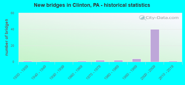
- New bridges - historical statistics
- 11930-1939
- 11940-1949
- 11960-1969
- 21970-1979
- 21980-1989
- 41990-1999
- 402000-2009
- 12010-2019

- Reconstructed bridges - Historical Statistics
- 11990-1999
- 02000-2009
- 42010-2019


- Bridge Condition - Deck
- 4.2%Excellent
- 12.5%Very good
- 83.3%Good

- Bridge Condition - Superstructure
- 4.2%Excellent
- 25.0%Very good
- 54.2%Good
- 4.2%Satisfactory
- 12.5%Fair

- Bridge Condition - Substructure
- 4.2%Excellent
- 8.3%Very good
- 70.8%Good
- 4.2%Satisfactory
- 12.5%Fair

- Bridge Condition - Channel
- 38.9%Very good
- 16.7%Good
- 22.2%Satisfactory
- 22.2%Fair
Find on map >> Show street view
Structure Number: 1833, Location: NEAR SR 3089 (Lat: 40.471042, Lng: -80.308286), Route carried "on" structure: State highway , Year Built: 1940, Year Reconstructed: 2004, Status: Open, Structure Length: 0.85m (2.79ft), Average Daily Traffic: 408 (year 2022), Truck Traffic: 8%, Average Future Daily Traffic: 257 (year 2032), Design Load: HS 20, Features Intersected: POTATO GARDEN RUN, Facility Carried by Structure: POTATO GARDEN RD
Minimum Vertical Clearance: 30+ m (98+ ft), Kilometerpoint: 5.123, Lanes on structure: 2, Owner: State Highway Agency, Approaching Roadway Width: 7.3m (24.0ft), Skew: 4 degrees, Material/Design: Concrete, Design/Construction: Slab, Number Of Spans In Main Unit: 1, Length of Maximum Span: 7.9m (25.9ft), Curb-To-Curb Width: 7.6m (24.9ft), Out-to-Out Width: 8.6m (28.2ft)
Condition: Deck: Good, Superstructure: Good, Substructure: Fair, Channel: Satisfactory, Operating Rating: 78.9 metric tons, Method Used To Determine Operating Rating: Load Factor (LF), Inventory Rating: 47.2 metric tons, Method Used To Determine Inventory Rating: Load Factor (LF), Structural Evaluation: Somewhat better than minimum adequacy, Deck Geometry: Meets minimum limits, Waterway Adequacy: Equal to present desirable criteria, Approach Roadway Alignment: Better than present minimum criteria, Length Of Structure Improvement: 0.90m (2.95ft), Designated Inspection Frequency: Every 24 months, Inspection Date: November 2019, Bridge Improvement Cost: $15,000, Roadway Improvement Cost: $43,000, Total Project Cost: $197,000, Deck Structure Type: Concrete Cast-file-Place, Wearing Surface/Protective System: Wearing Surface: Monolithic Concrete, Deck Protection: Epoxy Coated Reinforcing
Find on map >> Show street view
Structure Number: 185, Location: MOON CLINTON RD OVER 0060 (Lat: 40.498575, Lng: -80.281594), Route carried "on" structure: State highway , Year Built: 1992, Status: Open, Structure Length: 8.23m (27.00ft), Average Daily Traffic: 4,560 (year 2022), Truck Traffic: 14%, Average Future Daily Traffic: 7,760 (year 2032), Design Load: HS 20, Features Intersected: SR 0376 EB WB, Facility Carried by Structure: MOON CLINTON RD
Minimum Vertical Clearance: 30+ m (98+ ft), Kilometerpoint: 6.531, Lanes on structure: 2, Lanes under structure: 8, Owner: State Highway Agency, Approaching Roadway Width: 8.8m (28.9ft), Skew: 22 degrees, Material/Design: Steel continuous, Design/Construction: Stringer/Multi-beam, Number Of Spans In Main Unit: 2, Length of Maximum Span: 40.2m (131.9ft), Curb or Sidewalk Widths: Left: 0.2m (0.7ft), Right: 0.2m (0.7ft), Curb-To-Curb Width: 8.8m (28.9ft), Out-to-Out Width: 18.8m (61.7ft)
Condition: Deck: Very good, Superstructure: Good, Substructure: Good, Operating Rating: 50.8 metric tons, Method Used To Determine Operating Rating: Load Factor (LF), Inventory Rating: 29.9 metric tons, Method Used To Determine Inventory Rating: Load Factor (LF), Structural Evaluation: Better than present minimum criteria, Deck Geometry: Meets minimum limits, Underclear: Better than present minimum criteria, Approach Roadway Alignment: Equal to present desirable criteria, Length Of Structure Improvement: 8.20m (26.90ft), Designated Inspection Frequency: Every 24 months, Inspection Date: October 2019, Bridge Improvement Cost: $28,000, Roadway Improvement Cost: $82,000, Total Project Cost: $377,000, Deck Structure Type: Concrete Cast-file-Place, Wearing Surface/Protective System: Wearing Surface: Monolithic Concrete, Deck Protection: Epoxy Coated Reinforcing
Find on map >> Show street view
Structure Number: 3469, Location: LR 538 OVER RACCOON CREEK (Lat: 40.499153, Lng: -80.363403), Route carried "on" structure: US 30, Year Built: 1984, Year Reconstructed: 2010, Status: Open, Structure Length: 4.33m (14.21ft), Average Daily Traffic: 4,819 (year 2021), Truck Traffic: 10%, Average Future Daily Traffic: 7,968 (year 2032), Design Load: HS 20, Features Intersected: OVER RACCOON CR., Facility Carried by Structure: LINCOLN HW
Minimum Vertical Clearance: 30+ m (98+ ft), Kilometerpoint: 18.944, Lanes on structure: 2, Base Highway Network: Yes, Owner: State Highway Agency, Approaching Roadway Width: 10.1m (33.1ft), Material/Design: Prestressed concrete, Design/Construction: Box Beam or Girders - Multiple, Number Of Spans In Main Unit: 2, Length of Maximum Span: 21.3m (69.9ft), Curb or Sidewalk Widths: Left: 0.2m (0.7ft), Right: 0.2m (0.7ft), Curb-To-Curb Width: 10.1m (33.1ft), Out-to-Out Width: 11.1m (36.4ft)
Condition: Deck: Good, Superstructure: Satisfactory, Substructure: Satisfactory, Channel: Satisfactory, Inventory Rating: 60.8 metric tons, Method Used To Determine Inventory Rating: Load Factor (LF), Structural Evaluation: Equal to present minimum criteria, Deck Geometry: Meets minimum limits, Waterway Adequacy: Equal to present minimum criteria, Approach Roadway Alignment: Better than present minimum criteria, Length Of Structure Improvement: 5.20m (17.06ft), Designated Inspection Frequency: Every 24 months, Inspection Date: October 2020, Deck Structure Type: Concrete Cast-file-Place, Wearing Surface/Protective System: Wearing Surface: Monolithic Concrete, Deck Protection: Epoxy Coated Reinforcing
Find on map >> Show street view
Structure Number: 3716, Location: 50' WEST OF TWP. RD. 480 (Lat: 40.515931, Lng: -80.356764), Route carried "on" structure: State highway , Year Built: 1934, Status: Open, Structure Length: 0.70m (2.30ft), Average Daily Traffic: 421 (year 2021), Truck Traffic: 7%, Average Future Daily Traffic: 795 (year 2032), Design Load: HS 20, Features Intersected: BR.LITTLE TRAVERSE CREEK, Facility Carried by Structure: PARK RD
Minimum Vertical Clearance: 30+ m (98+ ft), Kilometerpoint: 0.000, Lanes on structure: 2, Owner: State Highway Agency, Approaching Roadway Width: 7.3m (24.0ft), Material/Design: Concrete, Design/Construction: Tee Beam, Number Of Spans In Main Unit: 1, Length of Maximum Span: 6.1m (20.0ft), Curb-To-Curb Width: 6.7m (22.0ft), Out-to-Out Width: 7.6m (24.9ft)
Condition: Deck: Good, Superstructure: Fair, Substructure: Fair, Channel: Fair, Operating Rating: 52.6 metric tons, Method Used To Determine Operating Rating: Load Factor (LF), Inventory Rating: 30.8 metric tons, Method Used To Determine Inventory Rating: Load Factor (LF), Structural Evaluation: Somewhat better than minimum adequacy, Deck Geometry: Meets minimum limits, Waterway Adequacy: Meets minimum limits, Approach Roadway Alignment: Equal to present desirable criteria, Length Of Structure Improvement: 0.70m (2.30ft), Designated Inspection Frequency: Every 24 months, Inspection Date: April 2021, Bridge Improvement Cost: $4,000, Roadway Improvement Cost: $29,000, Total Project Cost: $51,000, Deck Structure Type: Concrete Cast-file-Place, Wearing Surface/Protective System: Wearing Surface: Bituminous
Find on map >> Show street view
Structure Number: 3864, Location: 004036 LINK'S BRIDGE (Lat: 40.521950, Lng: -80.335881), Route carried "on" structure: City street , Year Built: 2007, Status: Open, Structure Length: 4.27m (14.01ft), Average Daily Traffic: 117 (year 2019), Truck Traffic: 2%, Average Future Daily Traffic: 130 (year 2039), Design Load: HL 93, Features Intersected: RACCOON CREEK, Facility Carried by Structure: E-HOOKSTOWN RD
Minimum Vertical Clearance: 30+ m (98+ ft), Kilometerpoint: 0.000, Lanes on structure: 2, Owner: County Highway Agency, Approaching Roadway Width: 7.9m (25.9ft), Material/Design: Steel, Design/Construction: Stringer/Multi-beam, Number Of Spans In Main Unit: 1, Length of Maximum Span: 41.1m (134.8ft), Curb or Sidewalk Widths: Left: 0.2m (0.7ft), Right: 0.2m (0.7ft), Curb-To-Curb Width: 7.9m (25.9ft), Out-to-Out Width: 9.0m (29.5ft)
Condition: Deck: Good, Superstructure: Good, Substructure: Good, Channel: Fair, Operating Rating: 50.2 metric tons, Method Used To Determine Operating Rating: Assigned ratings based on Load and Resistance Factor Design (LRFD) reported by rating factor (RF) using HL93 loadings, Inventory Rating: 38.6 metric tons, Method Used To Determine Inventory Rating: Assigned ratings based on Load and Resistance Factor Design (LRFD) reported by rating factor (RF) using HL93 loadings, Structural Evaluation: Better than present minimum criteria, Deck Geometry: Somewhat better than minimum adequacy, Waterway Adequacy: Superior to present desirable criteria, Approach Roadway Alignment: Equal to present desirable criteria, Length Of Structure Improvement: 4.30m (14.11ft), Designated Inspection Frequency: Every 24 months, Inspection Date: July 2021, Bridge Improvement Cost: $65,000, Roadway Improvement Cost: $190,000, Total Project Cost: $873,000, Deck Structure Type: Concrete Cast-file-Place, Wearing Surface/Protective System: Wearing Surface: Monolithic Concrete, Deck Protection: Epoxy Coated Reinforcing
Find on map >> Show street view
Structure Number: 3867, Location: 004038 0.2 MI S/SR0151 (Lat: 40.540317, Lng: -80.325453), Route carried "on" structure: City street , Year Built: 1989, Year Reconstructed: 2017, Status: Open, Structure Length: 0.91m (2.99ft), Average Daily Traffic: 150 (year 2019), Truck Traffic: 2%, Average Future Daily Traffic: 200 (year 2041), Design Load: HS 25 or greater, Features Intersected: RACCOON CREEK TRIB., Facility Carried by Structure: TWP ROUTE 514 RT
Minimum Vertical Clearance: 30+ m (98+ ft), Kilometerpoint: 0.000, Lanes on structure: 2, Owner: County Highway Agency, Approaching Roadway Width: 6.1m (20.0ft), Skew: 1 degrees, Material/Design: Prestressed concrete, Design/Construction: Box Beam or Girders - Multiple, Number Of Spans In Main Unit: 1, Length of Maximum Span: 8.2m (26.9ft), Curb or Sidewalk Widths: Left: 0.2m (0.7ft), Right: 0.2m (0.7ft), Curb-To-Curb Width: 7.6m (24.9ft), Out-to-Out Width: 8.6m (28.2ft)
Condition: Deck: Very good, Superstructure: Fair, Substructure: Good, Channel: Fair, Inventory Rating: 71.7 metric tons, Method Used To Determine Inventory Rating: Load Factor (LF), Structural Evaluation: Somewhat better than minimum adequacy, Deck Geometry: Somewhat better than minimum adequacy, Waterway Adequacy: Better than present minimum criteria, Approach Roadway Alignment: Equal to present desirable criteria, Length Of Structure Improvement: 0.90m (2.95ft), Designated Inspection Frequency: Every 24 months, Inspection Date: April 2021, Wearing Surface/Protective System: Wearing Surface: Monolithic Concrete, Deck Protection: Epoxy Coated Reinforcing
Find on map >> Show street view
Structure Number: 387, Location: 004040 0.5MI S/INT T-550 (Lat: 40.525875, Lng: -80.300528), Route carried "on" structure: City street , Year Built: 1990, Year Reconstructed: 2017, Status: Open, Structure Length: 1.68m (5.51ft), Average Daily Traffic: 70 (year 2021), Truck Traffic: 2%, Average Future Daily Traffic: 70 (year 2043), Design Load: HS 25 or greater, Features Intersected: RAREDON RUN, Facility Carried by Structure: TWP ROUTE-544 RT
Minimum Vertical Clearance: 30+ m (98+ ft), Kilometerpoint: 0.000, Lanes on structure: 2, Owner: County Highway Agency, Approaching Roadway Width: 8.2m (26.9ft), Skew: 4 degrees, Material/Design: Prestressed concrete, Design/Construction: Box Beam or Girders - Multiple, Number Of Spans In Main Unit: 1, Length of Maximum Span: 16.2m (53.1ft), Curb or Sidewalk Widths: Left: 0.2m (0.7ft), Right: 0.2m (0.7ft), Curb-To-Curb Width: 7.6m (24.9ft), Out-to-Out Width: 8.6m (28.2ft)
Condition: Deck: Good, Superstructure: Fair, Substructure: Good, Channel: Satisfactory, Operating Rating: 81.6 metric tons, Method Used To Determine Operating Rating: Load Factor (LF), Inventory Rating: 35.4 metric tons, Method Used To Determine Inventory Rating: Load Factor (LF), Structural Evaluation: Somewhat better than minimum adequacy, Deck Geometry: Equal to present minimum criteria, Waterway Adequacy: Equal to present desirable criteria, Approach Roadway Alignment: Equal to present desirable criteria, Length Of Structure Improvement: 1.60m (5.25ft), Designated Inspection Frequency: Every 24 months, Inspection Date: Febuary 2021, Wearing Surface/Protective System: Wearing Surface: Monolithic Concrete, Deck Protection: Epoxy Coated Reinforcing
Find on map >> Show street view
Structure Number: 41609, Location: ALLEGHENY-BEAVER CO. LINE (Lat: 40.518831, Lng: -80.303514), Route carried "on" structure: State highway , Year Built: 2002, Status: Open, Structure Length: 0.91m (2.99ft), Average Daily Traffic: 282 (year 2021), Truck Traffic: 3%, Average Future Daily Traffic: 610 (year 2032), Design Load: HS 20, Features Intersected: RAREDON RUN, Facility Carried by Structure: HOOKSTOWN GRADE RD
Minimum Vertical Clearance: 30+ m (98+ ft), Kilometerpoint: 0.000, Lanes on structure: 2, Owner: State Highway Agency, Approaching Roadway Width: 9.8m (32.2ft), Skew: 1 degrees, Material/Design: Prestressed concrete, Design/Construction: Box Beam or Girders - Multiple, Number Of Spans In Main Unit: 1, Length of Maximum Span: 8.8m (28.9ft), Curb or Sidewalk Widths: Left: 0.2m (0.7ft), Right: 0.2m (0.7ft), Curb-To-Curb Width: 10.2m (33.5ft), Out-to-Out Width: 11.2m (36.7ft)
Condition: Deck: Good, Superstructure: Very good, Substructure: Very good, Channel: Satisfactory, Inventory Rating: 50.8 metric tons, Method Used To Determine Inventory Rating: Load Factor (LF), Structural Evaluation: Equal to present desirable criteria, Deck Geometry: Better than present minimum criteria, Waterway Adequacy: Better than present minimum criteria, Approach Roadway Alignment: Equal to present desirable criteria, Length Of Structure Improvement: 0.90m (2.95ft), Designated Inspection Frequency: Every 24 months, Inspection Date: November 2019, Deck Structure Type: Concrete Cast-file-Place, Wearing Surface/Protective System: Wearing Surface: Epoxy Overlay
Find on map >> Show street view
Structure Number: 43534, Location: FINDLAY (Lat: 40.458856, Lng: -80.301178), Route carried "on" structure: Interstate 576, Year Built: 2006, Status: Open, Structure Length: 19.02m (62.40ft), Average Daily Traffic: 2,025 (year 2008), Truck Traffic: 8%, Average Future Daily Traffic: 7,300 (year 2030), Design Load: HL 93, Features Intersected: POTATO GARDEN RD, RUN
Minimum Vertical Clearance: 30+ m (98+ ft), Kilometerpoint: 5.633, Lanes on structure: 2, Lanes under structure: 2, Base Highway Network: Yes, Toll: On toll road, Owner: State Toll Authority, Approaching Roadway Width: 12.2m (40.0ft), Skew: 10 degrees, Material/Design: Steel continuous, Design/Construction: Stringer/Multi-beam, Number Of Spans In Main Unit: 3, Length of Maximum Span: 71.6m (234.9ft), Curb-To-Curb Width: 12.8m (42.0ft), Out-to-Out Width: 13.8m (45.3ft)
Condition: Deck: Good, Superstructure: Good, Substructure: Good, Channel: Very good, Operating Rating: 77.1 metric tons, Method Used To Determine Operating Rating: Load Factor (LF), Inventory Rating: 46.3 metric tons, Method Used To Determine Inventory Rating: Load Factor (LF), Structural Evaluation: Better than present minimum criteria, Deck Geometry: Equal to present desirable criteria, Underclear: Equal to present desirable criteria, Waterway Adequacy: Superior to present desirable criteria, Approach Roadway Alignment: Equal to present desirable criteria, Length Of Structure Improvement: 19.00m (62.34ft), Designated Inspection Frequency: Every 48 months, Inspection Date: June 2019, Deck Structure Type: Concrete Cast-file-Place, Wearing Surface/Protective System: Wearing Surface: Monolithic Concrete, Deck Protection: Epoxy Coated Reinforcing
Find on map >> Show street view
Structure Number: 43535, Location: FINDLAY (Lat: 40.459142, Lng: -80.301264), Route carried "on" structure: Interstate 576, Year Built: 2004, Status: Open, Structure Length: 19.02m (62.40ft), Average Daily Traffic: 2,025 (year 2008), Truck Traffic: 8%, Average Future Daily Traffic: 7,300 (year 2030), Design Load: HL 93, Features Intersected: SR3071, POTATO GARD RUN
Minimum Vertical Clearance: 30+ m (98+ ft), Kilometerpoint: 5.633, Lanes on structure: 2, Lanes under structure: 2, Base Highway Network: Yes, Toll: On toll road, Owner: State Toll Authority, Approaching Roadway Width: 12.8m (42.0ft), Skew: 10 degrees, Material/Design: Steel continuous, Design/Construction: Stringer/Multi-beam, Number Of Spans In Main Unit: 3, Length of Maximum Span: 71.6m (234.9ft), Curb-To-Curb Width: 12.8m (42.0ft), Out-to-Out Width: 13.8m (45.3ft)
Condition: Deck: Good, Superstructure: Good, Substructure: Good, Channel: Very good, Operating Rating: 77.1 metric tons, Method Used To Determine Operating Rating: Load Factor (LF), Inventory Rating: 46.3 metric tons, Method Used To Determine Inventory Rating: Load Factor (LF), Structural Evaluation: Better than present minimum criteria, Deck Geometry: Equal to present desirable criteria, Underclear: Better than present minimum criteria, Waterway Adequacy: Superior to present desirable criteria, Approach Roadway Alignment: Equal to present desirable criteria, Length Of Structure Improvement: 19.00m (62.34ft), Designated Inspection Frequency: Every 48 months, Inspection Date: June 2019, Deck Structure Type: Concrete Cast-file-Place, Wearing Surface/Protective System: Wearing Surface: Monolithic Concrete, Deck Protection: Epoxy Coated Reinforcing
Find on map >> Show street view
Structure Number: 43554, Location: FINDLAY (Lat: 40.472881, Lng: -80.281258), Route carried "on" structure: Other road 576, Year Built: 2006, Status: Open, Structure Length: 5.64m (18.50ft), Average Daily Traffic: 2,025 (year 2008), Truck Traffic: 8%, Average Future Daily Traffic: 7,300 (year 2030), Design Load: HL 93, Features Intersected: SR 0030
Minimum Vertical Clearance: 30+ m (98+ ft), Kilometerpoint: 1.609, Lanes on structure: 2, Lanes under structure: 2, Base Highway Network: Yes, Toll: On toll road, Owner: State Toll Authority, Approaching Roadway Width: 12.2m (40.0ft), Skew: 11 degrees, Material/Design: Steel, Design/Construction: Stringer/Multi-beam, Number Of Spans In Main Unit: 1, Length of Maximum Span: 54.6m (179.1ft), Curb or Sidewalk Widths: Left: 0.2m (0.7ft), Right: 0.2m (0.7ft), Curb-To-Curb Width: 12.8m (42.0ft), Out-to-Out Width: 13.8m (45.3ft)
Condition: Deck: Good, Superstructure: Very good, Substructure: Good, Inventory Rating: 64.4 metric tons, Method Used To Determine Inventory Rating: Load Factor (LF), Structural Evaluation: Better than present minimum criteria, Deck Geometry: Equal to present desirable criteria, Underclear: Superior to present desirable criteria, Approach Roadway Alignment: Equal to present desirable criteria, Length Of Structure Improvement: 5.60m (18.37ft), Designated Inspection Frequency: Every 48 months, Inspection Date: May 2019, Deck Structure Type: Concrete Cast-file-Place, Wearing Surface/Protective System: Wearing Surface: Monolithic Concrete, Deck Protection: Epoxy Coated Reinforcing
Find on map >> Show street view
Structure Number: 43562, Location: FINDLAY (Lat: 40.473086, Lng: -80.281439), Route carried "on" structure: Other road 576, Year Built: 2006, Status: Open, Structure Length: 5.64m (18.50ft), Average Daily Traffic: 2,025 (year 2008), Truck Traffic: 10%, Average Future Daily Traffic: 7,300 (year 2030), Design Load: HL 93, Features Intersected: SR 0030
Minimum Vertical Clearance: 30+ m (98+ ft), Kilometerpoint: 1.609, Lanes on structure: 2, Lanes under structure: 2, Base Highway Network: Yes, Toll: On toll road, Owner: State Toll Authority, Approaching Roadway Width: 12.2m (40.0ft), Skew: 11 degrees, Material/Design: Steel, Design/Construction: Stringer/Multi-beam, Number Of Spans In Main Unit: 1, Length of Maximum Span: 54.6m (179.1ft), Curb or Sidewalk Widths: Left: 0.2m (0.7ft), Right: 0.2m (0.7ft), Curb-To-Curb Width: 12.8m (42.0ft), Out-to-Out Width: 13.8m (45.3ft)
Condition: Deck: Good, Superstructure: Very good, Substructure: Good, Inventory Rating: 64.4 metric tons, Method Used To Determine Inventory Rating: Load Factor (LF), Structural Evaluation: Better than present minimum criteria, Deck Geometry: Equal to present desirable criteria, Underclear: Superior to present desirable criteria, Approach Roadway Alignment: Equal to present desirable criteria, Length Of Structure Improvement: 5.60m (18.37ft), Designated Inspection Frequency: Every 48 months, Inspection Date: May 2019, Deck Structure Type: Concrete Cast-file-Place, Wearing Surface/Protective System: Wearing Surface: Monolithic Concrete, Deck Protection: Epoxy Coated Reinforcing
Find on map >> Show street view
Structure Number: 43979, Location: FINDLAY TWP (Lat: 40.489214, Lng: -80.270236), Route carried "on" structure: Ramp State highway , Year Built: 2006, Status: Open, Structure Length: 15.42m (50.59ft), Average Daily Traffic: 2,025 (year 2008), Truck Traffic: 8%, Average Future Daily Traffic: 7,300 (year 2030), Design Load: H 15, Features Intersected: SR 60, RAMPS C, MT-B, KL, Facility Carried by Structure: PA TPK (I-576)
Minimum Vertical Clearance: 30+ m (98+ ft), Kilometerpoint: 0.000, Lanes on structure: 1, Lanes under structure: 6, Base Highway Network: Yes, Toll: On toll road, Owner: State Toll Authority, Approaching Roadway Width: 10.1m (33.1ft), Skew: 2 degrees, Material/Design: Steel continuous, Design/Construction: Stringer/Multi-beam, Number Of Spans In Main Unit: 4, Length of Maximum Span: 38.1m (125.0ft), Curb-To-Curb Width: 10.1m (33.1ft), Out-to-Out Width: 11.1m (36.4ft)
Condition: Deck: Good, Superstructure: Good, Substructure: Good, Operating Rating: 73.5 metric tons, Method Used To Determine Operating Rating: Load Factor (LF), Inventory Rating: 44.5 metric tons, Method Used To Determine Inventory Rating: Load Factor (LF), Structural Evaluation: Better than present minimum criteria, Deck Geometry: Superior to present desirable criteria, Underclear: Equal to present minimum criteria, Approach Roadway Alignment: Equal to present desirable criteria, Length Of Structure Improvement: 16.90m (55.45ft), Designated Inspection Frequency: Every 48 months, Inspection Date: June 2019, Deck Structure Type: Concrete Cast-file-Place, Wearing Surface/Protective System: Wearing Surface: Monolithic Concrete, Deck Protection: Epoxy Coated Reinforcing
Find on map >> Show street view
Structure Number: 4398, Location: FINDLAY (Lat: 40.487547, Lng: -80.270492), Route carried "on" structure: Ramp Interstate 576, Year Built: 2006, Status: Open, Structure Length: 47.40m (155.51ft), Average Daily Traffic: 2,025 (year 2008), Truck Traffic: 8%, Average Future Daily Traffic: 2,633 (year 2030), Design Load: H 15, Features Intersected: SR 376, RAMPS, RD, STRM
Minimum Vertical Clearance: 30+ m (98+ ft), Kilometerpoint: 0.161, Lanes on structure: 1, Lanes under structure: 10, Base Highway Network: Yes, Toll: On toll road, Owner: State Toll Authority, Approaching Roadway Width: 10.1m (33.1ft), Material/Design: Steel continuous, Design/Construction: Stringer/Multi-beam, Number Of Spans In Main Unit: 8, Length of Maximum Span: 64.3m (211.0ft), Curb or Sidewalk Widths: Left: 0.2m (0.7ft), Right: 0.2m (0.7ft), Curb-To-Curb Width: 10.1m (33.1ft), Out-to-Out Width: 11.1m (36.4ft)
Condition: Deck: Good, Superstructure: Good, Substructure: Good, Channel: Very good, Operating Rating: 69.9 metric tons, Method Used To Determine Operating Rating: Load Factor (LF), Inventory Rating: 41.7 metric tons, Method Used To Determine Inventory Rating: Load Factor (LF), Structural Evaluation: Better than present minimum criteria, Deck Geometry: Superior to present desirable criteria, Underclear: Equal to present minimum criteria, Waterway Adequacy: Equal to present desirable criteria, Approach Roadway Alignment: Equal to present desirable criteria, Length Of Structure Improvement: 48.90m (160.43ft), Designated Inspection Frequency: Every 48 months, Inspection Date: June 2019, Deck Structure Type: Concrete Cast-file-Place, Wearing Surface/Protective System: Wearing Surface: Monolithic Concrete, Deck Protection: Epoxy Coated Reinforcing
Find on map >> Show street view
Structure Number: 43981, Location: FINDLAY (Lat: 40.487747, Lng: -80.270697), Route carried "on" structure: Interstate 576, Year Built: 2006, Status: Open, Structure Length: 47.37m (155.41ft), Average Daily Traffic: 2,025 (year 2008), Truck Traffic: 8%, Average Future Daily Traffic: 2,633 (year 2030), Design Load: H 15, Features Intersected: SR 0060, RAMPS, RD, STRM
Minimum Vertical Clearance: 30+ m (98+ ft), Kilometerpoint: 0.145, Lanes on structure: 2, Lanes under structure: 10, Base Highway Network: Yes, Toll: On toll road, Owner: State Toll Authority, Approaching Roadway Width: 10.1m (33.1ft), Material/Design: Steel continuous, Design/Construction: Stringer/Multi-beam, Number Of Spans In Main Unit: 8, Length of Maximum Span: 64.3m (211.0ft), Curb-To-Curb Width: 10.1m (33.1ft), Out-to-Out Width: 11.1m (36.4ft)
Condition: Deck: Good, Superstructure: Very good, Substructure: Good, Channel: Good, Operating Rating: 69.9 metric tons, Method Used To Determine Operating Rating: Load Factor (LF), Inventory Rating: 41.7 metric tons, Method Used To Determine Inventory Rating: Load Factor (LF), Structural Evaluation: Better than present minimum criteria, Deck Geometry: Meets minimum limits, Underclear: Better than present minimum criteria, Waterway Adequacy: Superior to present desirable criteria, Approach Roadway Alignment: Equal to present desirable criteria, Length Of Structure Improvement: 48.90m (160.43ft), Designated Inspection Frequency: Every 48 months, Inspection Date: June 2019, Deck Structure Type: Concrete Cast-file-Place, Wearing Surface/Protective System: Wearing Surface: Monolithic Concrete, Deck Protection: Epoxy Coated Reinforcing
Find on map >> Show street view
Structure Number: 45349, Location: FINDLAY (Lat: 40.487225, Lng: -80.272133), Route carried "on" structure: Ramp Interstate 576, Year Built: 2006, Status: Open, Structure Length: 19.78m (64.90ft), Average Daily Traffic: 2,025 (year 2008), Truck Traffic: 8%, Average Future Daily Traffic: 7,300 (year 2030), Design Load: HS 25 or greater, Features Intersected: McCASLIN RD, ENLOW RUN
Minimum Vertical Clearance: 30+ m (98+ ft), Kilometerpoint: 0.000, Lanes on structure: 1, Lanes under structure: 2, Base Highway Network: Yes, Toll: On toll road, Owner: State Toll Authority, Approaching Roadway Width: 10.1m (33.1ft), Material/Design: Steel continuous, Design/Construction: Stringer/Multi-beam, Number Of Spans In Main Unit: 4, Length of Maximum Span: 58.5m (191.9ft), Curb-To-Curb Width: 10.1m (33.1ft), Out-to-Out Width: 11.1m (36.4ft)
Condition: Deck: Good, Superstructure: Good, Substructure: Good, Channel: Good, Operating Rating: 80.7 metric tons, Method Used To Determine Operating Rating: Load Factor (LF), Inventory Rating: 48.1 metric tons, Method Used To Determine Inventory Rating: Load Factor (LF), Structural Evaluation: Better than present minimum criteria, Deck Geometry: Superior to present desirable criteria, Underclear: Superior to present desirable criteria, Waterway Adequacy: Superior to present desirable criteria, Approach Roadway Alignment: Equal to present desirable criteria, Designated Inspection Frequency: Every 48 months, Inspection Date: June 2019, Deck Structure Type: Concrete Cast-file-Place, Wearing Surface/Protective System: Wearing Surface: Monolithic Concrete, Deck Protection: Epoxy Coated Reinforcing
Find on map >> Show street view
Structure Number: 45354, Location: FINDLAY TWP (Lat: 40.448422, Lng: -80.308275), Route carried "on" structure: Other road 576, Year Built: 2006, Status: Open, Structure Length: 4.57m (14.99ft), Average Daily Traffic: 2,025 (year 2008), Truck Traffic: 8%, Average Future Daily Traffic: 7,300 (year 2030), Design Load: HS 20, Features Intersected: T-439 BALD KNOB ROAD
Minimum Vertical Clearance: 30+ m (98+ ft), Kilometerpoint: 0.000, Lanes on structure: 2, Lanes under structure: 3, Base Highway Network: Yes, Toll: Toll bridge, Owner: State Toll Authority, Approaching Roadway Width: 12.8m (42.0ft), Skew: 10 degrees, Material/Design: Steel, Design/Construction: Stringer/Multi-beam, Number Of Spans In Main Unit: 1, Length of Maximum Span: 43.9m (144.0ft), Curb-To-Curb Width: 12.8m (42.0ft), Out-to-Out Width: 13.8m (45.3ft)
Condition: Deck: Good, Superstructure: Good, Substructure: Good, Operating Rating: 73.5 metric tons, Method Used To Determine Operating Rating: Load Factor (LF), Inventory Rating: 44.5 metric tons, Method Used To Determine Inventory Rating: Load Factor (LF), Structural Evaluation: Better than present minimum criteria, Deck Geometry: Equal to present desirable criteria, Underclear: Better than present minimum criteria, Approach Roadway Alignment: Equal to present desirable criteria, Designated Inspection Frequency: Every 48 months, Inspection Date: May 2019, Deck Structure Type: Concrete Cast-file-Place, Wearing Surface/Protective System: Wearing Surface: Monolithic Concrete, Deck Protection: Epoxy Coated Reinforcing
Find on map >> Show street view
Structure Number: 45355, Location: FINDLAY TWP (Lat: 40.448364, Lng: -80.307964), Route carried "on" structure: Other road 576, Year Built: 2006, Status: Open, Structure Length: 4.57m (14.99ft), Average Daily Traffic: 2,025 (year 2008), Truck Traffic: 8%, Average Future Daily Traffic: 7,300 (year 2030), Design Load: HS 20, Features Intersected: T-439 BALD KNOB ROAD
Minimum Vertical Clearance: 30+ m (98+ ft), Kilometerpoint: 0.000, Lanes on structure: 2, Lanes under structure: 3, Base Highway Network: Yes, Toll: On toll road, Owner: State Toll Authority, Approaching Roadway Width: 12.8m (42.0ft), Skew: 10 degrees, Material/Design: Steel, Design/Construction: Stringer/Multi-beam, Number Of Spans In Main Unit: 1, Length of Maximum Span: 43.9m (144.0ft), Curb-To-Curb Width: 12.8m (42.0ft), Out-to-Out Width: 13.8m (45.3ft)
Condition: Deck: Good, Superstructure: Very good, Substructure: Good, Operating Rating: 73.5 metric tons, Method Used To Determine Operating Rating: Load Factor (LF), Inventory Rating: 43.5 metric tons, Method Used To Determine Inventory Rating: Load Factor (LF), Structural Evaluation: Better than present minimum criteria, Deck Geometry: Equal to present desirable criteria, Underclear: Superior to present desirable criteria, Approach Roadway Alignment: Equal to present desirable criteria, Designated Inspection Frequency: Every 48 months, Inspection Date: May 2019, Deck Structure Type: Concrete Cast-file-Place, Wearing Surface/Protective System: Wearing Surface: Monolithic Concrete, Deck Protection: Epoxy Coated Reinforcing
Find on map >> Show street view
Structure Number: 45356, Location: FINDLAY TWP (Lat: 40.465856, Lng: -80.290833), Route carried "on" structure: Other road 576, Year Built: 2006, Status: Open, Structure Length: 5.82m (19.09ft), Average Daily Traffic: 2,025 (year 2008), Truck Traffic: 8%, Average Future Daily Traffic: 12,000 (year 2025), Design Load: HS 20, Features Intersected: TR TO POTATO GARDEN RUN
Minimum Vertical Clearance: 30+ m (98+ ft), Kilometerpoint: 0.000, Lanes on structure: 2, Base Highway Network: Yes, Toll: Toll bridge, Owner: State Toll Authority, Approaching Roadway Width: 12.2m (40.0ft), Skew: 2 degrees, Material/Design: Steel, Design/Construction: Stringer/Multi-beam, Number Of Spans In Main Unit: 1, Length of Maximum Span: 56.4m (185.0ft), Curb-To-Curb Width: 12.8m (42.0ft), Out-to-Out Width: 13.8m (45.3ft)
Condition: Deck: Good, Superstructure: Good, Substructure: Good, Channel: Very good, Inventory Rating: 63.5 metric tons, Method Used To Determine Inventory Rating: Load Factor (LF), Structural Evaluation: Better than present minimum criteria, Deck Geometry: Equal to present desirable criteria, Waterway Adequacy: Superior to present desirable criteria, Approach Roadway Alignment: Equal to present desirable criteria, Designated Inspection Frequency: Every 48 months, Inspection Date: May 2019, Deck Structure Type: Concrete Cast-file-Place, Wearing Surface/Protective System: Wearing Surface: Monolithic Concrete, Deck Protection: Epoxy Coated Reinforcing
Find on map >> Show street view
Structure Number: 45357, Location: FINDLAY TWP (Lat: 40.465572, Lng: -80.290767), Route carried "on" structure: Other road 576, Year Built: 2006, Status: Open, Structure Length: 5.82m (19.09ft), Average Daily Traffic: 2,025 (year 2008), Truck Traffic: 8%, Average Future Daily Traffic: 12,000 (year 2025), Design Load: HS 20, Features Intersected: TR TO POTATO GARDEN RUN
Minimum Vertical Clearance: 30+ m (98+ ft), Kilometerpoint: 0.000, Lanes on structure: 2, Base Highway Network: Yes, Toll: Toll bridge, Owner: State Toll Authority, Approaching Roadway Width: 12.2m (40.0ft), Skew: 2 degrees, Material/Design: Steel, Design/Construction: Stringer/Multi-beam, Number Of Spans In Main Unit: 1, Length of Maximum Span: 56.4m (185.0ft), Curb-To-Curb Width: 12.8m (42.0ft), Out-to-Out Width: 13.8m (45.3ft)
Condition: Deck: Good, Superstructure: Good, Substructure: Good, Channel: Very good, Inventory Rating: 63.5 metric tons, Method Used To Determine Inventory Rating: Load Factor (LF), Structural Evaluation: Better than present minimum criteria, Deck Geometry: Equal to present desirable criteria, Waterway Adequacy: Superior to present desirable criteria, Approach Roadway Alignment: Equal to present desirable criteria, Designated Inspection Frequency: Every 48 months, Inspection Date: May 2019, Deck Structure Type: Concrete Cast-file-Place, Wearing Surface/Protective System: Wearing Surface: Monolithic Concrete, Deck Protection: Epoxy Coated Reinforcing
Find on map >> Show street view
Structure Number: 45363, Location: FINDLAY TWP (Lat: 40.487111, Lng: -80.271953), Route carried "on" structure: Ramp Interstate 576, Year Built: 2006, Status: Open, Structure Length: 21.37m (70.11ft), Average Daily Traffic: 2,025 (year 2008), Truck Traffic: 8%, Average Future Daily Traffic: 8,650 (year 2025), Design Load: HS 20, Features Intersected: MCCASLIN RUN, ENLOW RUN
Minimum Vertical Clearance: 30+ m (98+ ft), Kilometerpoint: 0.000, Lanes on structure: 1, Lanes under structure: 2, Base Highway Network: Yes, Toll: On toll road, Owner: State Toll Authority, Approaching Roadway Width: 10.1m (33.1ft), Material/Design: Steel continuous, Design/Construction: Stringer/Multi-beam, Number Of Spans In Main Unit: 4, Length of Maximum Span: 58.8m (192.9ft), Curb-To-Curb Width: 10.1m (33.1ft), Out-to-Out Width: 11.1m (36.4ft)
Condition: Deck: Good, Superstructure: Good, Substructure: Good, Channel: Good, Operating Rating: 59.9 metric tons, Method Used To Determine Operating Rating: Load Factor (LF), Inventory Rating: 35.4 metric tons, Method Used To Determine Inventory Rating: Load Factor (LF), Structural Evaluation: Better than present minimum criteria, Deck Geometry: Superior to present desirable criteria, Underclear: Superior to present desirable criteria, Waterway Adequacy: Superior to present desirable criteria, Approach Roadway Alignment: Equal to present desirable criteria, Designated Inspection Frequency: Every 48 months, Inspection Date: June 2019, Deck Structure Type: Concrete Cast-file-Place, Wearing Surface/Protective System: Wearing Surface: Monolithic Concrete, Deck Protection: Epoxy Coated Reinforcing
Find on map >> Show street view
Structure Number: 45364, Location: FINDLAY TWP (Lat: 40.486483, Lng: -80.271525), Route carried "on" structure: Ramp Other road 576, Year Built: 2006, Status: Open, Structure Length: 18.07m (59.28ft), Average Daily Traffic: 2,025 (year 2008), Truck Traffic: 8%, Average Future Daily Traffic: 7,300 (year 2030), Design Load: HL 93, Features Intersected: MCCASLIN RD, ENLOW RUN
Minimum Vertical Clearance: 30+ m (98+ ft), Kilometerpoint: 0.000, Lanes on structure: 1, Lanes under structure: 2, Base Highway Network: Yes, Toll: On toll road, Owner: State Toll Authority, Approaching Roadway Width: 10.1m (33.1ft), Material/Design: Steel continuous, Design/Construction: Stringer/Multi-beam, Number Of Spans In Main Unit: 4, Length of Maximum Span: 54.3m (178.1ft), Curb-To-Curb Width: 10.1m (33.1ft), Out-to-Out Width: 11.1m (36.4ft)
Condition: Deck: Good, Superstructure: Good, Substructure: Fair, Channel: Very good, Operating Rating: 80.7 metric tons, Method Used To Determine Operating Rating: Load Factor (LF), Inventory Rating: 48.1 metric tons, Method Used To Determine Inventory Rating: Load Factor (LF), Structural Evaluation: Somewhat better than minimum adequacy, Deck Geometry: Superior to present desirable criteria, Underclear: Superior to present desirable criteria, Waterway Adequacy: Superior to present desirable criteria, Approach Roadway Alignment: Equal to present desirable criteria, Designated Inspection Frequency: Every 24 months, Inspection Date: June 2021, Deck Structure Type: Concrete Cast-file-Place, Wearing Surface/Protective System: Wearing Surface: Monolithic Concrete, Deck Protection: Epoxy Coated Reinforcing
Find on map >> Show street view
Structure Number: 53363, Location: 0.1 MI SW OF SR 151 (Lat: 40.541783, Lng: -80.300400), Route carried "on" structure: State highway , Year Built: 2016, Status: Open, Structure Length: 1.77m (5.81ft), Average Daily Traffic: 533 (year 2022), Truck Traffic: 2%, Average Future Daily Traffic: 863 (year 2037), Design Load: HL 93, Features Intersected: Raredon Run, Facility Carried by Structure: Bocktown Cork Rd
Minimum Vertical Clearance: 30+ m (98+ ft), Kilometerpoint: 5.285, Lanes on structure: 2, Owner: State Highway Agency, Maintenance Responsibility: Private, Approaching Roadway Width: 9.4m (30.8ft), Material/Design: Prestressed concrete, Design/Construction: Box Beam or Girders - Single/Spread, Number Of Spans In Main Unit: 1, Length of Maximum Span: 17.1m (56.1ft), Curb-To-Curb Width: 10.3m (33.8ft), Out-to-Out Width: 10.9m (35.8ft)
Condition: Deck: Excellent, Superstructure: Excellent, Substructure: Excellent, Channel: Fair, Operating Rating: 51.2 metric tons, Method Used To Determine Operating Rating: Assigned ratings based on Load and Resistance Factor Design (LRFD) reported by rating factor (RF) using HL93 loadings, Inventory Rating: 39.5 metric tons, Method Used To Determine Inventory Rating: Assigned ratings based on Load and Resistance Factor Design (LRFD) reported by rating factor (RF) using HL93 loadings, Structural Evaluation: Superior to present desirable criteria, Deck Geometry: Equal to present minimum criteria, Waterway Adequacy: Superior to present desirable criteria, Approach Roadway Alignment: Somewhat better than minimum adequacy, Designated Inspection Frequency: Every 24 months, Inspection Date: July 2020, Deck Structure Type: Concrete Cast-file-Place, Wearing Surface/Protective System: Wearing Surface: Integral Concrete, Deck Protection: Epoxy Coated Reinforcing
Find on map >> Show street view
Structure Number: 54591, Location: 4.4 mi E from SR 0018 (Lat: 40.477733, Lng: -80.362014), Route carried "on" structure: State highway , Year Built: 1962, Year Reconstructed: 2017, Status: Open, Structure Length: 3.17m (10.40ft), Average Daily Traffic: 532 (year 2021), Truck Traffic: 17%, Average Future Daily Traffic: 1,128 (year 2032), Design Load: HL 93, Features Intersected: Raccoon Creek, Facility Carried by Structure: SR 4002
Minimum Vertical Clearance: 30+ m (98+ ft), Kilometerpoint: 7.186, Lanes on structure: 2, Owner: State Highway Agency, Approaching Roadway Width: 6.7m (22.0ft), Skew: 2 degrees, Material/Design: Prestressed concrete, Design/Construction: Box Beam or Girders - Multiple, Number Of Spans In Main Unit: 1, Length of Maximum Span: 31.4m (103.0ft), Curb-To-Curb Width: 9.4m (30.8ft), Out-to-Out Width: 10.1m (33.1ft)
Condition: Deck: Very good, Superstructure: Very good, Substructure: Very good, Channel: Very good, Operating Rating: 54.1 metric tons, Method Used To Determine Operating Rating: Assigned ratings based on Load and Resistance Factor Design (LRFD) reported by rating factor (RF) using HL93 loadings, Inventory Rating: 41.8 metric tons, Method Used To Determine Inventory Rating: Assigned ratings based on Load and Resistance Factor Design (LRFD) reported by rating factor (RF) using HL93 loadings, Structural Evaluation: Equal to present desirable criteria, Deck Geometry: Equal to present minimum criteria, Waterway Adequacy: Better than present minimum criteria, Approach Roadway Alignment: Somewhat better than minimum adequacy, Designated Inspection Frequency: Every 24 months, Inspection Date: June 2020, Deck Structure Type: Concrete Cast-file-Place, Wearing Surface/Protective System: Wearing Surface: Monolithic Concrete, Deck Protection: Epoxy Coated Reinforcing
Find on map >> Show street view
Structure Number: 1848, Location: OVER SR 3160 (Lat: 40.518750, Lng: -80.303731), Route carried "under" structure: Interstate 376B, Year Built: 1970, Structure Length: 0. m, Average Daily Traffic: 4,962 (year 2022), Truck Traffic: 2%, Features Intersected: BUSINESS 376, Facility Carried by Structure: HOOKSTOWN GRADE RD
Minimum Vertical Clearance: 4.50m (14.76ft), Kilometerpoint: 0.000, Lanes on structure: 2, Lanes under structure: 6, Material/Design: Prestressed concrete, Design/Construction: Stringer/Multi-beam, Length of Maximum Span: 28.0m (91.9ft)
Find on map >> Show street view
Structure Number: 1848, Location: OVER SR 3160 (Lat: 40.518750, Lng: -80.303731), Route carried "under" structure: Interstate 376B, Year Built: 1970, Structure Length: 0. m, Average Daily Traffic: 4,973 (year 2022), Truck Traffic: 2%, Features Intersected: BUSINESS 376, Facility Carried by Structure: HOOKSTOWN GRADE RD
Minimum Vertical Clearance: 4.50m (14.76ft), Kilometerpoint: 0.000, Lanes on structure: 2, Lanes under structure: 6, Material/Design: Prestressed concrete, Design/Construction: Stringer/Multi-beam, Length of Maximum Span: 28.0m (91.9ft)
Find on map >> Show street view
Structure Number: 185, Location: MOON CLINTON RD OVER 0060 (Lat: 40.498575, Lng: -80.281594), Route carried "under" structure: Interstate 376, Year Built: 1992, Structure Length: 0. m, Average Daily Traffic: 13,351 (year 2021), Truck Traffic: 23%, Features Intersected: SR 0376 EB WB, Facility Carried by Structure: MOON CLINTON RD
Minimum Vertical Clearance: 5.97m (19.59ft), Kilometerpoint: 4.550, Lanes on structure: 2, Lanes under structure: 4, Material/Design: Steel continuous, Design/Construction: Stringer/Multi-beam, Length of Maximum Span: 40.2m (131.9ft)
Find on map >> Show street view
Structure Number: 185, Location: MOON CLINTON RD OVER 0060 (Lat: 40.498575, Lng: -80.281594), Route carried "under" structure: Interstate 376, Year Built: 1992, Structure Length: 0. m, Average Daily Traffic: 14,959 (year 2021), Truck Traffic: 18%, Features Intersected: SR 0376 EB WB, Facility Carried by Structure: MOON CLINTON RD
Minimum Vertical Clearance: 5.97m (19.59ft), Kilometerpoint: 4.583, Lanes on structure: 2, Lanes under structure: 4, Material/Design: Steel continuous, Design/Construction: Stringer/Multi-beam, Length of Maximum Span: 40.2m (131.9ft)
Find on map >> Show street view
Structure Number: 43534, Location: FINDLAY (Lat: 40.458856, Lng: -80.301178), Route carried "under" structure: State highway , Year Built: 2006, Structure Length: 0. m, Average Daily Traffic: 985 (year 2020), Truck Traffic: 17%, Features Intersected: POTATO GARDEN RD, RUN, Facility Carried by Structure: PA TPK (I-576)
Minimum Vertical Clearance: 18.62m (61.09ft), Kilometerpoint: 3.985, Lanes on structure: 2, Lanes under structure: 2, Material/Design: Steel continuous, Design/Construction: Stringer/Multi-beam, Length of Maximum Span: 71.6m (234.9ft)
Find on map >> Show street view
Structure Number: 43535, Location: FINDLAY (Lat: 40.459142, Lng: -80.301264), Route carried "under" structure: State highway , Year Built: 2004, Structure Length: 0. m, Average Daily Traffic: 985 (year 2020), Truck Traffic: 17%, Features Intersected: SR3071, POTATO GARD RUN, Facility Carried by Structure: PA TPK (I-576)
Minimum Vertical Clearance: 19.60m (64.30ft), Kilometerpoint: 3.985, Lanes on structure: 2, Lanes under structure: 2, Material/Design: Steel continuous, Design/Construction: Stringer/Multi-beam, Length of Maximum Span: 71.6m (234.9ft)
Find on map >> Show street view
Structure Number: 43554, Location: FINDLAY (Lat: 40.472881, Lng: -80.281258), Route carried "under" structure: US 30, Year Built: 2006, Structure Length: 0. m, Average Daily Traffic: 1,588 (year 2020), Truck Traffic: 11%, Features Intersected: SR 0030, Facility Carried by Structure: PA TPK (I-576)
Minimum Vertical Clearance: 7.29m (23.92ft), Kilometerpoint: 6.397, Lanes on structure: 2, Lanes under structure: 1, Material/Design: Steel, Design/Construction: Stringer/Multi-beam, Length of Maximum Span: 54.6m (179.1ft)
Find on map >> Show street view
Structure Number: 43554, Location: FINDLAY (Lat: 40.472881, Lng: -80.281258), Route carried "under" structure: US 30, Year Built: 2006, Structure Length: 0. m, Average Daily Traffic: 1,588 (year 2020), Truck Traffic: 11%, Features Intersected: SR 0030, Facility Carried by Structure: PA TPK (I-576)
Minimum Vertical Clearance: 30+ m (98+ ft), Kilometerpoint: 6.397, Lanes on structure: 2, Lanes under structure: 1, Material/Design: Steel, Design/Construction: Stringer/Multi-beam, Length of Maximum Span: 54.6m (179.1ft)
Find on map >> Show street view
Structure Number: 43562, Location: FINDLAY (Lat: 40.473086, Lng: -80.281439), Route carried "under" structure: US 30, Year Built: 2006, Structure Length: 0. m, Average Daily Traffic: 1,588 (year 2020), Truck Traffic: 11%, Features Intersected: SR 0030, Facility Carried by Structure: PA TPK (I-576)
Minimum Vertical Clearance: 30+ m (98+ ft), Kilometerpoint: 6.397, Lanes on structure: 2, Lanes under structure: 1, Material/Design: Steel, Design/Construction: Stringer/Multi-beam, Length of Maximum Span: 54.6m (179.1ft)
Find on map >> Show street view
Structure Number: 43562, Location: FINDLAY (Lat: 40.473086, Lng: -80.281439), Route carried "under" structure: US 30, Year Built: 2006, Structure Length: 0. m, Average Daily Traffic: 1,588 (year 2020), Truck Traffic: 11%, Features Intersected: SR 0030, Facility Carried by Structure: PA TPK (I-576)
Minimum Vertical Clearance: 5.63m (18.47ft), Kilometerpoint: 6.397, Lanes on structure: 2, Lanes under structure: 1, Material/Design: Steel, Design/Construction: Stringer/Multi-beam, Length of Maximum Span: 54.6m (179.1ft)
Find on map >> Show street view
Structure Number: 43979, Location: FINDLAY TWP (Lat: 40.489214, Lng: -80.270236), Route carried "under" structure: Ramp State highway , Year Built: 2006, Structure Length: 0. m, Average Daily Traffic: 3,742 (year 2021), Truck Traffic: 6%, Features Intersected: SR 60, RAMPS C, MT-B, KL, Facility Carried by Structure: PA TPK (I-576)
Minimum Vertical Clearance: 8.49m (27.85ft), Kilometerpoint: 0.000, Lanes on structure: 1, Lanes under structure: 1, Material/Design: Steel continuous, Design/Construction: Stringer/Multi-beam, Length of Maximum Span: 38.1m (125.0ft)
Find on map >> Show street view
Structure Number: 43979, Location: FINDLAY TWP (Lat: 40.489214, Lng: -80.270236), Route carried "under" structure: Interstate 376, Year Built: 2006, Structure Length: 0. m, Average Daily Traffic: 22,027 (year 2020), Truck Traffic: 4%, Features Intersected: SR 60, RAMPS C, MT-B, KL, Facility Carried by Structure: PA TPK (I-576)
Minimum Vertical Clearance: 7.35m (24.11ft), Kilometerpoint: 6.159, Lanes on structure: 1, Lanes under structure: 2, Material/Design: Steel continuous, Design/Construction: Stringer/Multi-beam, Length of Maximum Span: 38.1m (125.0ft)
Find on map >> Show street view
Structure Number: 43979, Location: FINDLAY TWP (Lat: 40.489214, Lng: -80.270236), Route carried "under" structure: Interstate 376, Year Built: 2006, Structure Length: 0. m, Average Daily Traffic: 20,452 (year 2020), Truck Traffic: 6%, Features Intersected: SR 60, RAMPS C, MT-B, KL, Facility Carried by Structure: PA TPK (I-576)
Minimum Vertical Clearance: 8.63m (28.31ft), Kilometerpoint: 6.159, Lanes on structure: 1, Lanes under structure: 3, Material/Design: Steel continuous, Design/Construction: Stringer/Multi-beam, Length of Maximum Span: 38.1m (125.0ft)
Find on map >> Show street view
Structure Number: 4398, Location: FINDLAY (Lat: 40.487547, Lng: -80.270492), Route carried "under" structure: ServiceOther road , Year Built: 2006, Structure Length: 0. m, Features Intersected: SR 376, RAMPS, RD, STRM, Facility Carried by Structure: PA TPK (I-576)
Minimum Vertical Clearance: 30+ m (98+ ft), Kilometerpoint: 0.000, Lanes on structure: 1, Lanes under structure: 2, Material/Design: Steel continuous, Design/Construction: Stringer/Multi-beam, Length of Maximum Span: 64.3m (211.0ft)
Find on map >> Show street view
Structure Number: 4398, Location: FINDLAY (Lat: 40.487547, Lng: -80.270492), Route carried "under" structure: Ramp State highway , Year Built: 2006, Structure Length: 0. m, Average Daily Traffic: 5,188 (year 2021), Truck Traffic: 2%, Features Intersected: SR 376, RAMPS, RD, STRM, Facility Carried by Structure: PA TPK (I-576)
Minimum Vertical Clearance: 6.46m (21.19ft), Kilometerpoint: 0.000, Lanes on structure: 1, Lanes under structure: 2, Material/Design: Steel continuous, Design/Construction: Stringer/Multi-beam, Length of Maximum Span: 64.3m (211.0ft)
Find on map >> Show street view
Structure Number: 4398, Location: FINDLAY (Lat: 40.487547, Lng: -80.270492), Route carried "under" structure: Ramp State highway , Year Built: 2006, Structure Length: 0. m, Average Daily Traffic: 3,742 (year 2021), Truck Traffic: 6%, Features Intersected: SR 376, RAMPS, RD, STRM, Facility Carried by Structure: PA TPK (I-576)
Minimum Vertical Clearance: 11.23m (36.84ft), Kilometerpoint: 0.000, Lanes on structure: 1, Lanes under structure: 1, Material/Design: Steel continuous, Design/Construction: Stringer/Multi-beam, Length of Maximum Span: 64.3m (211.0ft)
Find on map >> Show street view
Structure Number: 4398, Location: FINDLAY (Lat: 40.487547, Lng: -80.270492), Route carried "under" structure: Interstate 376, Year Built: 2006, Structure Length: 0. m, Average Daily Traffic: 20,452 (year 2020), Truck Traffic: 6%, Features Intersected: SR 376, RAMPS, RD, STRM, Facility Carried by Structure: PA TPK (I-576)
Minimum Vertical Clearance: 12.47m (40.91ft), Kilometerpoint: 6.159, Lanes on structure: 1, Lanes under structure: 3, Material/Design: Steel continuous, Design/Construction: Stringer/Multi-beam, Length of Maximum Span: 64.3m (211.0ft)
Find on map >> Show street view
Structure Number: 4398, Location: FINDLAY (Lat: 40.487547, Lng: -80.270492), Route carried "under" structure: Interstate 376, Year Built: 2006, Structure Length: 0. m, Average Daily Traffic: 22,027 (year 2020), Truck Traffic: 4%, Features Intersected: SR 376, RAMPS, RD, STRM, Facility Carried by Structure: PA TPK (I-576)
Minimum Vertical Clearance: 11.55m (37.89ft), Kilometerpoint: 6.159, Lanes on structure: 1, Lanes under structure: 2, Material/Design: Steel continuous, Design/Construction: Stringer/Multi-beam, Length of Maximum Span: 64.3m (211.0ft)
Find on map >> Show street view
Structure Number: 43981, Location: FINDLAY (Lat: 40.487747, Lng: -80.270697), Route carried "under" structure: Interstate 376, Year Built: 2006, Structure Length: 0. m, Average Daily Traffic: 20,452 (year 2020), Truck Traffic: 6%, Features Intersected: SR 0060, RAMPS, RD, STRM, Facility Carried by Structure: PA TPK (I-576)
Minimum Vertical Clearance: 12.41m (40.72ft), Kilometerpoint: 6.159, Lanes on structure: 2, Lanes under structure: 3, Material/Design: Steel continuous, Design/Construction: Stringer/Multi-beam, Length of Maximum Span: 64.3m (211.0ft)
Find on map >> Show street view
Structure Number: 43981, Location: FINDLAY (Lat: 40.487747, Lng: -80.270697), Route carried "under" structure: Ramp State highway , Year Built: 2006, Structure Length: 0. m, Average Daily Traffic: 5,188 (year 2021), Truck Traffic: 2%, Features Intersected: SR 0060, RAMPS, RD, STRM, Facility Carried by Structure: PA TPK (I-576)
Minimum Vertical Clearance: 5.52m (18.11ft), Kilometerpoint: 0.000, Lanes on structure: 2, Lanes under structure: 2, Material/Design: Steel continuous, Design/Construction: Stringer/Multi-beam, Length of Maximum Span: 64.3m (211.0ft)
Find on map >> Show street view
Structure Number: 43981, Location: FINDLAY (Lat: 40.487747, Lng: -80.270697), Route carried "under" structure: Ramp State highway , Year Built: 2006, Structure Length: 0. m, Average Daily Traffic: 3,742 (year 2021), Truck Traffic: 6%, Features Intersected: SR 0060, RAMPS, RD, STRM, Facility Carried by Structure: PA TPK (I-576)
Minimum Vertical Clearance: 11.43m (37.50ft), Kilometerpoint: 0.000, Lanes on structure: 2, Lanes under structure: 1, Material/Design: Steel continuous, Design/Construction: Stringer/Multi-beam, Length of Maximum Span: 64.3m (211.0ft)
Find on map >> Show street view
Structure Number: 43981, Location: FINDLAY (Lat: 40.487747, Lng: -80.270697), Route carried "under" structure: Other road , Year Built: 2006, Structure Length: 0. m, Features Intersected: SR 0060, RAMPS, RD, STRM, Facility Carried by Structure: PA TPK (I-576)
Minimum Vertical Clearance: 30+ m (98+ ft), Kilometerpoint: 0.000, Lanes on structure: 2, Lanes under structure: 2, Toll: Toll bridge, Material/Design: Steel continuous, Design/Construction: Stringer/Multi-beam, Length of Maximum Span: 64.3m (211.0ft)
Find on map >> Show street view
Structure Number: 43981, Location: FINDLAY (Lat: 40.487747, Lng: -80.270697), Route carried "under" structure: Interstate 376, Year Built: 2006, Structure Length: 0. m, Average Daily Traffic: 22,027 (year 2020), Truck Traffic: 4%, Features Intersected: SR 0060, RAMPS, RD, STRM, Facility Carried by Structure: PA TPK (I-576)
Minimum Vertical Clearance: 11.46m (37.60ft), Kilometerpoint: 6.159, Lanes on structure: 2, Lanes under structure: 2, Material/Design: Steel continuous, Design/Construction: Stringer/Multi-beam, Length of Maximum Span: 64.3m (211.0ft)
Find on map >> Show street view
Structure Number: 45349, Location: FINDLAY (Lat: 40.487225, Lng: -80.272133), Route carried "under" structure: Other road , Year Built: 2006, Structure Length: 0. m, Features Intersected: McCASLIN RD, ENLOW RUN, Facility Carried by Structure: PA TPK (I-576)
Minimum Vertical Clearance: 20.64m (67.72ft), Kilometerpoint: 0.467, Lanes on structure: 1, Lanes under structure: 2, Toll: On toll road, Material/Design: Steel continuous, Design/Construction: Stringer/Multi-beam, Length of Maximum Span: 58.5m (191.9ft)
Find on map >> Show street view
Structure Number: 45354, Location: FINDLAY TWP (Lat: 40.448422, Lng: -80.308275), Route carried "under" structure: County highway , Year Built: 2006, Structure Length: 0. m, Average Daily Traffic: 130 (year 2009), Truck Traffic: 1%, Features Intersected: T-439 BALD KNOB ROAD, Facility Carried by Structure: PA TPK (I-576)
Minimum Vertical Clearance: 5.29m (17.36ft), Kilometerpoint: 0.000, Lanes on structure: 2, Lanes under structure: 3, Material/Design: Steel, Design/Construction: Stringer/Multi-beam, Length of Maximum Span: 43.9m (144.0ft)
Find on map >> Show street view
Structure Number: 45355, Location: FINDLAY TWP (Lat: 40.448364, Lng: -80.307964), Route carried "under" structure: Other road , Year Built: 2006, Structure Length: 0. m, Average Daily Traffic: 200 (year 2009), Truck Traffic: 1%, Features Intersected: T-439 BALD KNOB ROAD, Facility Carried by Structure: PA PTK (I-576), WB
Minimum Vertical Clearance: 5.69m (18.67ft), Kilometerpoint: 0.000, Lanes on structure: 2, Lanes under structure: 3, Material/Design: Steel, Design/Construction: Stringer/Multi-beam, Length of Maximum Span: 43.9m (144.0ft)
Find on map >> Show street view
Structure Number: 45363, Location: FINDLAY TWP (Lat: 40.487111, Lng: -80.271953), Route carried "under" structure: Other road , Year Built: 2006, Structure Length: 0. m, Features Intersected: MCCASLIN RUN, ENLOW RUN, Facility Carried by Structure: PA TPK (I-576)
Minimum Vertical Clearance: 29.64m (97.24ft), Kilometerpoint: 0.000, Lanes on structure: 1, Lanes under structure: 2, Toll: Toll bridge, Material/Design: Steel continuous, Design/Construction: Stringer/Multi-beam, Length of Maximum Span: 58.8m (192.9ft)
Find on map >> Show street view
Structure Number: 45364, Location: FINDLAY TWP (Lat: 40.486483, Lng: -80.271525), Route carried "under" structure: State highway 576, Year Built: 2006, Structure Length: 0. m, Features Intersected: MCCASLIN RD, ENLOW RUN
Minimum Vertical Clearance: 24.00m (78.74ft), Kilometerpoint: 0.515, Lanes on structure: 1, Lanes under structure: 2, Material/Design: Steel continuous, Design/Construction: Stringer/Multi-beam, Length of Maximum Span: 54.3m (178.1ft)