Bridge Statistics for Clinton, Michigan (MI)
Condition, Traffic, Stress, Structural Evaluation, Project Costs
- National Bridge Inventory (NBI) Statistics
- 34Number of bridges
- 318ft / 96.8mTotal length
- $1,306,000Total costs
- 591,510Total average daily traffic
- 35,184Total average daily truck traffic
- National Bridge Inventory (NBI) Registered Bridges for Clinton
- No street view available for this location
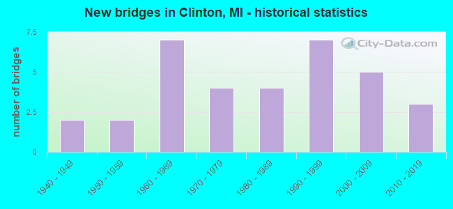
- New bridges - historical statistics
- 21940-1949
- 21950-1959
- 71960-1969
- 41970-1979
- 41980-1989
- 71990-1999
- 52000-2009
- 32010-2019

- Reconstructed bridges - Historical Statistics
- 11970-1979
- 11980-1989
- 11990-1999
- 42000-2009
- 22010-2019


- Bridge Condition - Deck
- 4.2%Excellent
- 25.0%Very good
- 50.0%Good
- 12.5%Satisfactory
- 8.3%Fair

- Bridge Condition - Superstructure
- 4.2%Excellent
- 54.2%Very good
- 20.8%Good
- 16.7%Satisfactory
- 4.2%Poor

- Bridge Condition - Substructure
- 33.3%Very good
- 37.5%Good
- 16.7%Satisfactory
- 8.3%Fair
- 4.2%Critical

- Bridge Condition - Channel
- 28.6%Very good
- 32.1%Good
- 28.6%Satisfactory
- 7.1%Fair
- 3.6%Poor

- Bridge Condition - Culverts
- 50.0%Very good
- 16.7%Good
- 33.3%Satisfactory
Find on map >> Show street view
Structure Number: 5541, Location: IN CLINTON (Lat: 42.071728, Lng: -83.979425), Route carried "on" structure: US 12, Year Built: 1977, Status: Open, Structure Length: 2.25m (7.38ft), Average Daily Traffic: 10,834 (year 2007), Truck Traffic: 6%, Average Future Daily Traffic: 12,822 (year 2018), Design Load: HS 25 or greater, Features Intersected: RIVER RAISIN
Minimum Vertical Clearance: 30.48m (100.00ft), Kilometerpoint: 10.685, Lanes on structure: 2, Base Highway Network: Yes (Inventory Route: 346, Subroute: 9), Owner: State Highway Agency, Approaching Roadway Width: 12.2m (40.0ft), Material/Design: Prestressed concrete, Design/Construction: Box Beam or Girders - Multiple, Number Of Spans In Main Unit: 1, Length of Maximum Span: 22.5m (73.8ft), Curb-To-Curb Width: 15.2m (49.9ft), Out-to-Out Width: 15.7m (51.5ft)
Condition: Deck: Fair, Superstructure: Satisfactory, Substructure: Satisfactory, Channel: Satisfactory, Operating Rating: 76.5 metric tons, Method Used To Determine Operating Rating: Load Factor (LF) rating reported by rating factor (RF) method using MS18 loading, Inventory Rating: 36.9 metric tons, Method Used To Determine Inventory Rating: Load Factor (LF) rating reported by rating factor (RF) method using MS18 loading, Structural Evaluation: Equal to present minimum criteria, Deck Geometry: Superior to present desirable criteria, Waterway Adequacy: Equal to present desirable criteria, Approach Roadway Alignment: Equal to present desirable criteria, Length Of Structure Improvement: 2.26m (7.41ft), Designated Inspection Frequency: Every 24 months, Inspection Date: September 2020, Bridge Improvement Cost: $154,000, Roadway Improvement Cost: $15,000, Total Project Cost: $171,000, Deck Structure Type: Concrete Cast-file-Place, Wearing Surface/Protective System: Wearing Surface: Monolithic Concrete
Find on map >> Show street view
Structure Number: 5578, Location: 0.1 MI E OF NEWBURG HWY (Lat: 42.042747, Lng: -83.966033), Route carried "on" structure: County highway , Year Built: 1950, Status: Posted for load, Structure Length: 3.66m (12.01ft), Average Daily Traffic: 5,403 (year 2011), Truck Traffic: 1%, Average Future Daily Traffic: 6,000 (year 2031), Design Load: H 15, Features Intersected: NORTH BR RAISIN RIVER, Facility Carried by Structure: STAIB ROAD
Minimum Vertical Clearance: 30.48m (100.00ft), Kilometerpoint: 1.638, Lanes on structure: 2, Owner: County Highway Agency, Approaching Roadway Width: 9.1m (29.9ft), Material/Design: Steel continuous, Design/Construction: Stringer/Multi-beam, Number Of Spans In Main Unit: 3, Length of Maximum Span: 15.2m (49.9ft), Curb or Sidewalk Widths: Left: 0.4m (1.3ft), Right: 0.4m (1.3ft), Curb-To-Curb Width: 6.7m (22.0ft), Out-to-Out Width: 8.2m (26.9ft)
Condition: Deck: Good, Superstructure: Good, Substructure: Satisfactory, Channel: Satisfactory, Operating Rating: 26.9 metric tons, Method Used To Determine Operating Rating: Load Factor (LF) rating reported by rating factor (RF) method using MS18 loading, Inventory Rating: 16.2 metric tons, Method Used To Determine Inventory Rating: Load Factor (LF) rating reported by rating factor (RF) method using MS18 loading, Structural Evaluation: Meets minimum limits, Deck Geometry: High priority of replacement, Waterway Adequacy: Equal to present desirable criteria, Approach Roadway Alignment: Equal to present minimum criteria, Bridge Posting: Required (Relationship of Operating Rating to Maximum Legal Load: 10.0 - 19.9% below), Length Of Structure Improvement: 4.57m (14.99ft), Designated Inspection Frequency: Every 12 months, Inspection Date: May 2021, Bridge Improvement Cost: $450,000, Roadway Improvement Cost: $60,000, Total Project Cost: $510,000, Deck Structure Type: Concrete Cast-file-Place, Wearing Surface/Protective System: Wearing Surface: Bituminous
Find on map >> Show street view
Structure Number: 6049, Location: 0.7 MI W OF M-97 (Lat: 42.629028, Lng: -82.889028), Route carried "on" structure: State highway 59, Year Built: 1996, Status: Open, Structure Length: 7.01m (23.00ft), Average Daily Traffic: 31,800 (year 2021), Truck Traffic: 3%, Average Future Daily Traffic: 35,150 (year 2041), Design Load: HS 25 or greater, Features Intersected: N BR CLINTON RIVER
Minimum Vertical Clearance: 30.48m (100.00ft), Kilometerpoint: 16.657, Lanes on structure: 3, Base Highway Network: Yes (Inventory Route: 80, Subroute: 1), Owner: State Highway Agency, Approaching Roadway Width: 14.6m (47.9ft), Material/Design: Prestressed concrete, Design/Construction: Stringer/Multi-beam, Number Of Spans In Main Unit: 3, Length of Maximum Span: 28.0m (91.9ft), Curb or Sidewalk Widths: Left: 0.0m, Right: 1.5m (4.9ft), Curb-To-Curb Width: 16.5m (54.1ft), Out-to-Out Width: 19.1m (62.7ft)
Condition: Deck: Good, Superstructure: Very good, Substructure: Very good, Channel: Very good, Operating Rating: 70.0 metric tons, Method Used To Determine Operating Rating: Load Factor (LF) rating reported by rating factor (RF) method using MS18 loading, Inventory Rating: 41.8 metric tons, Method Used To Determine Inventory Rating: Load Factor (LF) rating reported by rating factor (RF) method using MS18 loading, Structural Evaluation: Equal to present desirable criteria, Deck Geometry: Better than present minimum criteria, Waterway Adequacy: Somewhat better than minimum adequacy, Approach Roadway Alignment: Somewhat better than minimum adequacy, Designated Inspection Frequency: Every 24 months, Inspection Date: December 2021, Deck Structure Type: Concrete Cast-file-Place, Wearing Surface/Protective System: Wearing Surface: Epoxy Overlay, Deck Protection: Epoxy Coated Reinforcing
Find on map >> Show street view
Structure Number: 6066, Location: AT S LIMITS OF MT CLEMENS (Lat: 42.590667, Lng: -82.901425), Route carried "on" structure: State highway 97, Year Built: 1948, Year Reconstructed: 2005, Status: Open, Structure Length: 6.40m (21.00ft), Average Daily Traffic: 29,299 (year 2007), Truck Traffic: 13%, Average Future Daily Traffic: 41,000 (year 2025), Design Load: HS 20, Features Intersected: CLINTON RIVER
Minimum Vertical Clearance: 30+ m (98+ ft), Kilometerpoint: 17.932, Lanes on structure: 5, Base Highway Network: Yes (Inventory Route: 80, Subroute: 9), Owner: State Highway Agency, Approaching Roadway Width: 20.7m (67.9ft), Skew: 1 degrees, Material/Design: Steel, Design/Construction: Stringer/Multi-beam, Number Of Spans In Main Unit: 3, Length of Maximum Span: 21.3m (69.9ft), Curb or Sidewalk Widths: Left: 2.4m (7.9ft), Right: 2.4m (7.9ft), Curb-To-Curb Width: 20.7m (67.9ft), Out-to-Out Width: 26.6m (87.3ft)
Condition: Deck: Good, Superstructure: Good, Substructure: Satisfactory, Channel: Satisfactory, Operating Rating: 79.1 metric tons, Method Used To Determine Operating Rating: Load Factor (LF) rating reported by rating factor (RF) method using MS18 loading, Inventory Rating: 47.3 metric tons, Method Used To Determine Inventory Rating: Load Factor (LF) rating reported by rating factor (RF) method using MS18 loading, Structural Evaluation: Equal to present minimum criteria, Deck Geometry: Somewhat better than minimum adequacy, Waterway Adequacy: Somewhat better than minimum adequacy, Approach Roadway Alignment: Better than present minimum criteria, Designated Inspection Frequency: Every 24 months, Underwater Inspection Frequency: Every 60 months, Inspection Date: October 2020, Underwater Inspection Date: October 2020, Deck Structure Type: Concrete Cast-file-Place, Wearing Surface/Protective System: Wearing Surface: Monolithic Concrete, Membrane: Preformed Fabric, Deck Protection: Epoxy Coated Reinforcing
Find on map >> Show street view
Structure Number: 6166, Location: 0.7 MI S OF M-29 (Lat: 42.553178, Lng: -82.871539), Route carried "on" structure: Interstate 94, Year Built: 1964, Year Reconstructed: 2006, Status: Open, Structure Length: 5.29m (17.36ft), Average Daily Traffic: 49,849 (year 2007), Truck Traffic: 5%, Average Future Daily Traffic: 45,709 (year 2018), Design Load: HS 20+Mod, Features Intersected: HARPER RD
Minimum Vertical Clearance: 30.48m (100.00ft), Kilometerpoint: 13.693, Lanes on structure: 4, Lanes under structure: 4, Base Highway Network: Yes (Inventory Route: 79, Subroute: 1), Owner: State Highway Agency, Approaching Roadway Width: 19.8m (65.0ft), Skew: 13 degrees, Material/Design: Steel, Design/Construction: Stringer/Multi-beam, Number Of Spans In Main Unit: 3, Length of Maximum Span: 24.3m (79.7ft), Curb-To-Curb Width: 21.7m (71.2ft), Out-to-Out Width: 22.7m (74.5ft)
Condition: Deck: Very good, Superstructure: Very good, Substructure: Satisfactory, Operating Rating: 84.6 metric tons, Method Used To Determine Operating Rating: Load Factor (LF) rating reported by rating factor (RF) method using MS18 loading, Inventory Rating: 50.5 metric tons, Method Used To Determine Inventory Rating: Load Factor (LF) rating reported by rating factor (RF) method using MS18 loading, Structural Evaluation: Equal to present minimum criteria, Deck Geometry: Better than present minimum criteria, Underclear: High priority of corrective action, Approach Roadway Alignment: Better than present minimum criteria, Designated Inspection Frequency: Every 24 months, Inspection Date: June 2021, Deck Structure Type: Concrete Cast-file-Place, Wearing Surface/Protective System: Wearing Surface: Monolithic Concrete, Deck Protection: Epoxy Coated Reinforcing
Find on map >> Show street view
Structure Number: 6167, Location: 0.7 MI S OF M-29 (Lat: 42.553353, Lng: -82.871400), Route carried "on" structure: Interstate 94, Year Built: 1964, Year Reconstructed: 2006, Status: Open, Structure Length: 5.29m (17.36ft), Average Daily Traffic: 49,849 (year 2007), Truck Traffic: 5%, Average Future Daily Traffic: 45,709 (year 2018), Design Load: HS 20+Mod, Features Intersected: HARPER RD
Minimum Vertical Clearance: 30.48m (100.00ft), Kilometerpoint: 13.805, Lanes on structure: 4, Lanes under structure: 4, Base Highway Network: Yes (Inventory Route: 79, Subroute: 2), Owner: State Highway Agency, Approaching Roadway Width: 18.3m (60.0ft), Skew: 13 degrees, Material/Design: Steel, Design/Construction: Stringer/Multi-beam, Number Of Spans In Main Unit: 3, Length of Maximum Span: 24.1m (79.1ft), Curb-To-Curb Width: 21.7m (71.2ft), Out-to-Out Width: 22.7m (74.5ft)
Condition: Deck: Very good, Superstructure: Very good, Substructure: Good, Operating Rating: 87.5 metric tons, Method Used To Determine Operating Rating: Load Factor (LF) rating reported by rating factor (RF) method using MS18 loading, Inventory Rating: 52.5 metric tons, Method Used To Determine Inventory Rating: Load Factor (LF) rating reported by rating factor (RF) method using MS18 loading, Structural Evaluation: Better than present minimum criteria, Deck Geometry: Better than present minimum criteria, Underclear: High priority of corrective action, Approach Roadway Alignment: Better than present minimum criteria, Designated Inspection Frequency: Every 24 months, Inspection Date: June 2021, Deck Structure Type: Concrete Cast-file-Place, Wearing Surface/Protective System: Wearing Surface: Monolithic Concrete, Deck Protection: Epoxy Coated Reinforcing
Find on map >> Show street view
Structure Number: 6189, Location: 100 FT WEST OF I-94 (Lat: 42.547736, Lng: -82.880281), Route carried "on" structure: County highway , Year Built: 2016, Status: Open, Structure Length: 1.68m (5.51ft), Average Daily Traffic: 4,538 (year 2015), Truck Traffic: 5%, Average Future Daily Traffic: 6,613 (year 2035), Design Load: Greater than HL93, Features Intersected: CLINTON HARRISON DRAIN, Facility Carried by Structure: QUINN ROAD
Minimum Vertical Clearance: 30.48m (100.00ft), Kilometerpoint: 1.936, Lanes on structure: 2, Owner: County Highway Agency, Approaching Roadway Width: 8.5m (27.9ft), Skew: 3 degrees, Material/Design: Prestressed concrete, Design/Construction: Box Beam or Girders - Single/Spread, Number Of Spans In Main Unit: 1, Length of Maximum Span: 16.4m (53.8ft), Curb or Sidewalk Widths: Left: 1.7m (5.6ft), Right: 1.7m (5.6ft), Curb-To-Curb Width: 8.5m (27.9ft), Out-to-Out Width: 12.6m (41.3ft)
Condition: Deck: Very good, Superstructure: Very good, Substructure: Very good, Channel: Very good, Operating Rating: 86.5 metric tons, Method Used To Determine Operating Rating: Load and Resistance Factor Rating (LRFR) rating reported by rating factor(RF) method using HL-93 loadings, Inventory Rating: 66.7 metric tons, Method Used To Determine Inventory Rating: Load and Resistance Factor Rating (LRFR) rating reported by rating factor(RF) method using HL-93 loadings, Structural Evaluation: Equal to present desirable criteria, Deck Geometry: Meets minimum limits, Waterway Adequacy: Superior to present desirable criteria, Approach Roadway Alignment: Equal to present desirable criteria, Designated Inspection Frequency: Every 24 months, Inspection Date: October 2020, Deck Structure Type: Concrete Cast-file-Place, Wearing Surface/Protective System: Wearing Surface: Monolithic Concrete, Deck Protection: Epoxy Coated Reinforcing
Find on map >> Show street view
Structure Number: 619, Location: 0.5 MI SOUTH OF CASS AVE (Lat: 42.596189, Lng: -82.909206), Route carried "on" structure: County highway , Year Built: 2011, Status: Open, Structure Length: 7.26m (23.82ft), Average Daily Traffic: 8,493 (year 2009), Truck Traffic: 5%, Average Future Daily Traffic: 9,384 (year 2029), Design Load: Greater than HL93, Features Intersected: CLINTON RIVER, Facility Carried by Structure: MORAVIAN DRIVE
Minimum Vertical Clearance: 30.48m (100.00ft), Kilometerpoint: 9.433, Lanes on structure: 2, Owner: County Highway Agency, Approaching Roadway Width: 7.3m (24.0ft), Skew: 1 degrees, Material/Design: Prestressed concrete, Design/Construction: Box Beam or Girders - Single/Spread, Number Of Spans In Main Unit: 3, Length of Maximum Span: 23.9m (78.4ft), Curb or Sidewalk Widths: Left: 0.0m, Right: 4.3m (14.1ft), Curb-To-Curb Width: 9.8m (32.2ft), Out-to-Out Width: 15.1m (49.5ft)
Condition: Deck: Good, Superstructure: Very good, Substructure: Good, Channel: Very good, Operating Rating: 75.8 metric tons, Method Used To Determine Operating Rating: Load and Resistance Factor Rating (LRFR) rating reported by rating factor(RF) method using HL-93 loadings, Inventory Rating: 39.2 metric tons, Method Used To Determine Inventory Rating: Load and Resistance Factor Rating (LRFR) rating reported by rating factor(RF) method using HL-93 loadings, Structural Evaluation: Better than present minimum criteria, Deck Geometry: Meets minimum limits, Waterway Adequacy: Equal to present desirable criteria, Approach Roadway Alignment: Better than present minimum criteria, Designated Inspection Frequency: Every 24 months, Underwater Inspection Frequency: Every 60 months, Inspection Date: July 2021, Underwater Inspection Date: August 2018, Deck Structure Type: Concrete Cast-file-Place, Wearing Surface/Protective System: Wearing Surface: Monolithic Concrete, Deck Protection: Epoxy Coated Reinforcing
Find on map >> Show street view
Structure Number: 6191, Location: 300FT EAST OF GARFIELD RD (Lat: 42.553575, Lng: -82.948972), Route carried "on" structure: County highway 2058, Year Built: 2003, Status: Open, Structure Length: 0.61m (2.00ft), Average Daily Traffic: 23,660 (year 2007), Truck Traffic: 15%, Average Future Daily Traffic: 31,870 (year 2027), Design Load: H 20, Features Intersected: HARRINGTON DRAIN, Facility Carried by Structure: 15 MILE RD
Minimum Vertical Clearance: 30.48m (100.00ft), Kilometerpoint: 11.462, Lanes on structure: 5, Owner: County Highway Agency, Approaching Roadway Width: 18.3m (60.0ft), Material/Design: Concrete, Design/Construction: Culvert, Number Of Spans In Main Unit: 1, Length of Maximum Span: 6.1m (20.0ft)
Condition: Channel: Satisfactory, Culverts: Very good, Operating Rating: 61.2 metric tons, Method Used To Determine Operating Rating: Load Factor (LF) rating reported by rating factor (RF) method using MS18 loading, Inventory Rating: 36.6 metric tons, Method Used To Determine Inventory Rating: Load Factor (LF) rating reported by rating factor (RF) method using MS18 loading, Structural Evaluation: Equal to present desirable criteria, Waterway Adequacy: Superior to present desirable criteria, Approach Roadway Alignment: Equal to present desirable criteria, Designated Inspection Frequency: Every 24 months, Inspection Date: May 2021
Find on map >> Show street view
Structure Number: 6198, Location: 0.75 MI WEST OF M-97 (Lat: 42.568889, Lng: -82.928611), Route carried "on" structure: County highway 2058, Year Built: 1952, Year Reconstructed: 2010, Status: Open, Structure Length: 1.07m (3.51ft), Average Daily Traffic: 18,950 (year 2007), Truck Traffic: 10%, Average Future Daily Traffic: 25,526 (year 2027), Design Load: HS 25 or greater, Features Intersected: HARRINGTON DRAIN, Facility Carried by Structure: WB METRO PARKWAY
Minimum Vertical Clearance: 30.48m (100.00ft), Kilometerpoint: 10.070, Lanes on structure: 3, Base Highway Network: Yes (Inventory Route: 80, Subroute: 2), Owner: County Highway Agency, Approaching Roadway Width: 13.4m (44.0ft), Skew: 1 degrees, Material/Design: Prestressed concrete, Design/Construction: Box Beam or Girders - Single/Spread, Number Of Spans In Main Unit: 1, Length of Maximum Span: 10.2m (33.5ft), Curb-To-Curb Width: 15.3m (50.2ft), Out-to-Out Width: 16.2m (53.1ft)
Condition: Deck: Good, Superstructure: Very good, Substructure: Good, Channel: Very good, Operating Rating: 42.4 metric tons, Method Used To Determine Operating Rating: Load and Resistance Factor Rating (LRFR) rating reported by rating factor(RF) method using HL-93 loadings, Inventory Rating: 32.7 metric tons, Method Used To Determine Inventory Rating: Load and Resistance Factor Rating (LRFR) rating reported by rating factor(RF) method using HL-93 loadings, Structural Evaluation: Better than present minimum criteria, Deck Geometry: Equal to present minimum criteria, Waterway Adequacy: Equal to present desirable criteria, Approach Roadway Alignment: Equal to present desirable criteria, Designated Inspection Frequency: Every 24 months, Inspection Date: August 2020, Deck Structure Type: Concrete Cast-file-Place, Wearing Surface/Protective System: Wearing Surface: Monolithic Concrete, Deck Protection: Epoxy Coated Reinforcing
Find on map >> Show street view
Structure Number: 6201, Location: JUST WEST OF M-97 (Lat: 42.587844, Lng: -82.903744), Route carried "on" structure: County highway , Year Built: 1949, Year Reconstructed: 1980, Status: Open, Structure Length: 3.20m (10.50ft), Average Daily Traffic: 13,860 (year 2007), Truck Traffic: 5%, Average Future Daily Traffic: 20,596 (year 2027), Design Load: HS 20+Mod, Features Intersected: HARRINGTON DRAIN, Facility Carried by Structure: HARRINGTON ROAD
Minimum Vertical Clearance: 30.48m (100.00ft), Kilometerpoint: 0.851, Lanes on structure: 3, Owner: County Highway Agency, Approaching Roadway Width: 15.0m (49.2ft), Material/Design: Steel, Design/Construction: Stringer/Multi-beam, Number Of Spans In Main Unit: 3, Length of Maximum Span: 10.3m (33.8ft), Curb or Sidewalk Widths: Left: 1.5m (4.9ft), Right: 1.5m (4.9ft), Curb-To-Curb Width: 12.0m (39.4ft), Out-to-Out Width: 15.9m (52.2ft)
Condition: Deck: Good, Superstructure: Good, Substructure: Good, Channel: Good, Operating Rating: 74.8 metric tons, Method Used To Determine Operating Rating: Load Factor (LF) rating reported by rating factor (RF) method using MS18 loading, Inventory Rating: 45.0 metric tons, Method Used To Determine Inventory Rating: Load Factor (LF) rating reported by rating factor (RF) method using MS18 loading, Structural Evaluation: Better than present minimum criteria, Deck Geometry: Meets minimum limits, Waterway Adequacy: Superior to present desirable criteria, Approach Roadway Alignment: Equal to present minimum criteria, Designated Inspection Frequency: Every 24 months, Inspection Date: July 2021, Deck Structure Type: Concrete Cast-file-Place, Wearing Surface/Protective System: Wearing Surface: Integral Concrete, Deck Protection: Epoxy Coated Reinforcing
Find on map >> Show street view
Structure Number: 6205, Location: 0.25 MI WEST OF MORAVIAN (Lat: 42.601625, Lng: -82.910017), Route carried "on" structure: County highway 2058, Year Built: 1976, Status: Open, Structure Length: 8.68m (28.48ft), Average Daily Traffic: 30,901 (year 2010), Truck Traffic: 5%, Average Future Daily Traffic: 45,917 (year 2030), Design Load: HS 25 or greater, Features Intersected: NORTH BRANCH CLINTON RIV, Facility Carried by Structure: CASS AVE
Minimum Vertical Clearance: 30.48m (100.00ft), Kilometerpoint: 2.124, Lanes on structure: 2, Base Highway Network: Yes (Inventory Route: 81, Subroute: 9), Owner: County Highway Agency, Approaching Roadway Width: 17.1m (56.1ft), Skew: 3 degrees, Material/Design: Prestressed concrete, Design/Construction: Stringer/Multi-beam, Number Of Spans In Main Unit: 4, Length of Maximum Span: 21.9m (71.9ft), Curb or Sidewalk Widths: Left: 1.5m (4.9ft), Right: 1.5m (4.9ft), Curb-To-Curb Width: 18.0m (59.1ft), Out-to-Out Width: 21.7m (71.2ft)
Condition: Deck: Satisfactory, Superstructure: Satisfactory, Substructure: Fair, Channel: Fair, Operating Rating: 61.2 metric tons, Method Used To Determine Operating Rating: Load Factor (LF) rating reported by rating factor (RF) method using MS18 loading, Inventory Rating: 36.6 metric tons, Method Used To Determine Inventory Rating: Load Factor (LF) rating reported by rating factor (RF) method using MS18 loading, Structural Evaluation: Somewhat better than minimum adequacy, Deck Geometry: Superior to present desirable criteria, Waterway Adequacy: Somewhat better than minimum adequacy, Approach Roadway Alignment: Equal to present desirable criteria, Designated Inspection Frequency: Every 24 months, Underwater Inspection Frequency: Every 60 months, Inspection Date: April 2020, Underwater Inspection Date: August 2018, Deck Structure Type: Concrete Cast-file-Place, Wearing Surface/Protective System: Wearing Surface: Monolithic Concrete
Find on map >> Show street view
Structure Number: 6248, Location: 0.1 MI SOUTH OF HAYES RD (Lat: 42.568633, Lng: -82.969403), Route carried "on" structure: County highway 2058, Year Built: 1985, Status: Open, Structure Length: 8.38m (27.49ft), Average Daily Traffic: 17,850 (year 2010), Truck Traffic: 7%, Average Future Daily Traffic: 21,777 (year 2030), Design Load: HS 25 or greater, Features Intersected: RED RUN DRAIN, Facility Carried by Structure: UTICA RD
Minimum Vertical Clearance: 30.48m (100.00ft), Kilometerpoint: 7.939, Lanes on structure: 5, Owner: County Highway Agency, Approaching Roadway Width: 18.0m (59.1ft), Skew: 1 degrees, Material/Design: Prestressed concrete, Design/Construction: Stringer/Multi-beam, Number Of Spans In Main Unit: 4, Length of Maximum Span: 20.4m (66.9ft), Curb or Sidewalk Widths: Left: 1.5m (4.9ft), Right: 1.5m (4.9ft), Curb-To-Curb Width: 20.1m (65.9ft), Out-to-Out Width: 23.2m (76.1ft)
Condition: Deck: Satisfactory, Superstructure: Good, Substructure: Good, Channel: Satisfactory, Operating Rating: 77.4 metric tons, Method Used To Determine Operating Rating: Load Factor (LF) rating reported by rating factor (RF) method using MS18 loading, Inventory Rating: 46.3 metric tons, Method Used To Determine Inventory Rating: Load Factor (LF) rating reported by rating factor (RF) method using MS18 loading, Structural Evaluation: Better than present minimum criteria, Deck Geometry: Somewhat better than minimum adequacy, Waterway Adequacy: Equal to present desirable criteria, Approach Roadway Alignment: Better than present minimum criteria, Designated Inspection Frequency: Every 24 months, Underwater Inspection Frequency: Every 60 months, Inspection Date: October 2021, Underwater Inspection Date: August 2018, Deck Structure Type: Concrete Cast-file-Place, Wearing Surface/Protective System: Wearing Surface: Latex Concrete, Deck Protection: Epoxy Coated Reinforcing
Find on map >> Show street view
Structure Number: 6256, Location: 0.1 MI S OF CLINTON R RD (Lat: 42.577942, Lng: -82.952078), Route carried "on" structure: County highway 2058, Year Built: 1986, Year Reconstructed: 2000, Status: Open, Structure Length: 4.57m (14.99ft), Average Daily Traffic: 32,581 (year 2009), Truck Traffic: 7%, Average Future Daily Traffic: 43,887 (year 2029), Design Load: HS 25 or greater, Features Intersected: CLINTON RIVER, Facility Carried by Structure: GARFIELD RD
Minimum Vertical Clearance: 30.48m (100.00ft), Kilometerpoint: 5.029, Lanes on structure: 5, Base Highway Network: Yes (Inventory Route: 79, Subroute: 3), Owner: County Highway Agency, Approaching Roadway Width: 17.1m (56.1ft), Material/Design: Prestressed concrete, Design/Construction: Stringer/Multi-beam, Number Of Spans In Main Unit: 3, Length of Maximum Span: 14.9m (48.9ft), Curb or Sidewalk Widths: Left: 1.8m (5.9ft), Right: 1.8m (5.9ft), Curb-To-Curb Width: 17.1m (56.1ft), Out-to-Out Width: 21.7m (71.2ft)
Condition: Deck: Good, Superstructure: Very good, Substructure: Good, Channel: Fair, Operating Rating: 54.4 metric tons, Method Used To Determine Operating Rating: Load Factor (LF) rating reported by rating factor (RF) method using MS18 loading, Inventory Rating: 32.7 metric tons, Method Used To Determine Inventory Rating: Load Factor (LF) rating reported by rating factor (RF) method using MS18 loading, Structural Evaluation: Better than present minimum criteria, Deck Geometry: High priority of replacement, Waterway Adequacy: Equal to present desirable criteria, Approach Roadway Alignment: Equal to present desirable criteria, Designated Inspection Frequency: Every 24 months, Inspection Date: August 2020, Deck Structure Type: Concrete Cast-file-Place, Wearing Surface/Protective System: Wearing Surface: Latex Concrete, Deck Protection: Epoxy Coated Reinforcing
Find on map >> Show street view
Structure Number: 6257, Location: 0.3 MI SOUTH OF M-59 (Lat: 42.623994, Lng: -82.953325), Route carried "on" structure: County highway 2058, Year Built: 1975, Year Reconstructed: 1982, Status: Open, Structure Length: 0.88m (2.89ft), Average Daily Traffic: 37,769 (year 2008), Truck Traffic: 7%, Average Future Daily Traffic: 50,875 (year 2028), Design Load: H 20, Features Intersected: UTICA DRAIN, Facility Carried by Structure: GARFIELD RD
Minimum Vertical Clearance: 30.48m (100.00ft), Kilometerpoint: 10.118, Lanes on structure: 5, Base Highway Network: Yes (Inventory Route: 79, Subroute: 3), Owner: County Highway Agency, Approaching Roadway Width: 17.1m (56.1ft), Material/Design: Steel, Design/Construction: Culvert, Number Of Spans In Main Unit: 2, Length of Maximum Span: 3.9m (12.8ft)
Condition: Channel: Satisfactory, Culverts: Satisfactory, Operating Rating: 97.2 metric tons, Method Used To Determine Operating Rating: Load Factor (LF) rating reported by rating factor (RF) method using MS18 loading, Inventory Rating: 97.2 metric tons, Method Used To Determine Inventory Rating: Load Factor (LF) rating reported by rating factor (RF) method using MS18 loading, Structural Evaluation: Equal to present minimum criteria, Waterway Adequacy: Somewhat better than minimum adequacy, Approach Roadway Alignment: Equal to present desirable criteria, Designated Inspection Frequency: Every 24 months, Inspection Date: May 2020
Find on map >> Show street view
Structure Number: 6258, Location: 0.5 MILES SOUTH OF M-59 (Lat: 42.620203, Lng: -82.934381), Route carried "on" structure: County highway 2058, Year Built: 2009, Status: Open, Structure Length: 1.10m (3.61ft), Average Daily Traffic: 20,070 (year 2008), Truck Traffic: 6%, Average Future Daily Traffic: 22,175 (year 2028), Design Load: HS 20, Features Intersected: GLOEDE DRAIN, Facility Carried by Structure: ROMEO PLANK RD
Minimum Vertical Clearance: 30.48m (100.00ft), Kilometerpoint: 3.607, Lanes on structure: 5, Base Highway Network: Yes (Inventory Route: 81, Subroute: 7), Owner: County Highway Agency, Approaching Roadway Width: 18.3m (60.0ft), Material/Design: Concrete, Design/Construction: Culvert, Number Of Spans In Main Unit: 1, Length of Maximum Span: 11.0m (36.1ft), Curb or Sidewalk Widths: Left: 4.3m (14.1ft), Right: 0.0m, Curb-To-Curb Width: 19.5m (64.0ft), Out-to-Out Width: 25.2m (82.7ft)
Condition: Channel: Good, Culverts: Very good, Operating Rating: 42.1 metric tons, Method Used To Determine Operating Rating: Load and Resistance Factor Rating (LRFR) rating reported by rating factor(RF) method using HL-93 loadings, Inventory Rating: 32.4 metric tons, Method Used To Determine Inventory Rating: Load and Resistance Factor Rating (LRFR) rating reported by rating factor(RF) method using HL-93 loadings, Structural Evaluation: Equal to present desirable criteria, Deck Geometry: Meets minimum limits, Waterway Adequacy: Equal to present desirable criteria, Approach Roadway Alignment: Equal to present desirable criteria, Designated Inspection Frequency: Every 24 months, Inspection Date: July 2021
Find on map >> Show street view
Structure Number: 6263, Location: BET 15 MILE RD AND I-94 (Lat: 42.554494, Lng: -82.870525), Route carried "on" structure: County highway 2058, Year Built: 1964, Status: Open, Structure Length: 2.56m (8.40ft), Average Daily Traffic: 20,760 (year 2009), Truck Traffic: 5%, Average Future Daily Traffic: 27,964 (year 2029), Design Load: H 20, Features Intersected: CLINTON HARRISON DRAIN, Facility Carried by Structure: HARPER AVE
Minimum Vertical Clearance: 30.48m (100.00ft), Kilometerpoint: 12.503, Lanes on structure: 4, Base Highway Network: Yes (Inventory Route: 79, Subroute: 8), Owner: County Highway Agency, Approaching Roadway Width: 17.4m (57.1ft), Skew: 1 degrees, Material/Design: Steel, Design/Construction: Stringer/Multi-beam, Number Of Spans In Main Unit: 3, Length of Maximum Span: 8.2m (26.9ft), Curb or Sidewalk Widths: Left: 1.8m (5.9ft), Right: 1.8m (5.9ft), Curb-To-Curb Width: 17.4m (57.1ft), Out-to-Out Width: 21.7m (71.2ft)
Condition: Deck: Good, Superstructure: Good, Substructure: Very good, Channel: Very good, Operating Rating: 65.1 metric tons, Method Used To Determine Operating Rating: Load Factor (LF) rating reported by rating factor (RF) method using MS18 loading, Inventory Rating: 38.9 metric tons, Method Used To Determine Inventory Rating: Load Factor (LF) rating reported by rating factor (RF) method using MS18 loading, Structural Evaluation: Better than present minimum criteria, Deck Geometry: Somewhat better than minimum adequacy, Waterway Adequacy: Equal to present desirable criteria, Approach Roadway Alignment: Equal to present desirable criteria, Length Of Structure Improvement: 2.56m (8.40ft), Designated Inspection Frequency: Every 24 months, Inspection Date: July 2021, Bridge Improvement Cost: $235,000, Roadway Improvement Cost: $30,000, Total Project Cost: $265,000, Deck Structure Type: Concrete Cast-file-Place, Wearing Surface/Protective System: Wearing Surface: Monolithic Concrete
Find on map >> Show street view
Structure Number: 6281, Location: 0.1 MI NORTH OF 17 MILE (Lat: 42.585100, Lng: -82.940500), Route carried "on" structure: County highway , Year Built: 1977, Status: Open, Structure Length: 0.70m (2.30ft), Average Daily Traffic: 8,640 (year 2007), Truck Traffic: 5%, Average Future Daily Traffic: 12,839 (year 2027), Design Load: H 20, Features Intersected: KUKUK DRAIN, Facility Carried by Structure: CLINTON RIVER RD
Minimum Vertical Clearance: 30.48m (100.00ft), Kilometerpoint: 5.078, Lanes on structure: 2, Owner: County Highway Agency, Approaching Roadway Width: 12.0m (39.4ft), Material/Design: Concrete, Design/Construction: Culvert, Number Of Spans In Main Unit: 2, Length of Maximum Span: 3.0m (9.8ft)
Condition: Channel: Very good, Culverts: Satisfactory, Operating Rating: 57.2 metric tons, Method Used To Determine Operating Rating: Field evaluation and documented engineering judgment, Inventory Rating: 34.2 metric tons, Method Used To Determine Inventory Rating: Field evaluation and documented engineering judgment, Structural Evaluation: Equal to present minimum criteria, Waterway Adequacy: Equal to present desirable criteria, Approach Roadway Alignment: Better than present minimum criteria, Designated Inspection Frequency: Every 24 months, Inspection Date: May 2021
Find on map >> Show street view
Structure Number: 6315, Location: 0.5 MI NORTH OF 15 MILE (Lat: 42.561961, Lng: -82.931647), Route carried "on" structure: County highway , Year Built: 1980, Year Reconstructed: 2018, Status: Open, Structure Length: 0.98m (3.22ft), Average Daily Traffic: 4,700 (year 2018), Truck Traffic: 1%, Average Future Daily Traffic: 5,405 (year 2038), Design Load: Greater than HL93, Features Intersected: HARRINGTON DRAIN, Facility Carried by Structure: KELLY ROAD
Minimum Vertical Clearance: 30.48m (100.00ft), Kilometerpoint: 4.192, Lanes on structure: 2, Owner: County Highway Agency, Approaching Roadway Width: 9.5m (31.2ft), Material/Design: Prestressed concrete, Design/Construction: Box Beam or Girders - Multiple, Number Of Spans In Main Unit: 1, Length of Maximum Span: 9.4m (30.8ft), Curb-To-Curb Width: 9.5m (31.2ft), Out-to-Out Width: 10.5m (34.4ft)
Condition: Deck: Excellent, Superstructure: Excellent, Substructure: Good, Channel: Good, Operating Rating: 97.2 metric tons, Method Used To Determine Operating Rating: Load and Resistance Factor Rating (LRFR) rating reported by rating factor(RF) method using HL-93 loadings, Inventory Rating: 80.0 metric tons, Method Used To Determine Inventory Rating: Load and Resistance Factor Rating (LRFR) rating reported by rating factor(RF) method using HL-93 loadings, Structural Evaluation: Better than present minimum criteria, Deck Geometry: Meets minimum limits, Waterway Adequacy: Superior to present desirable criteria, Approach Roadway Alignment: Equal to present desirable criteria, Designated Inspection Frequency: Every 24 months, Inspection Date: September 2020, Deck Structure Type: Concrete Cast-file-Place, Wearing Surface/Protective System: Wearing Surface: Monolithic Concrete, Deck Protection: Epoxy Coated Reinforcing
Find on map >> Show street view
Structure Number: 6316, Location: 0.1 MI NORTH OF CASS AVE (Lat: 42.605975, Lng: -82.917531), Route carried "on" structure: County highway , Year Built: 1988, Status: Open, Structure Length: 2.59m (8.50ft), Average Daily Traffic: 11,500 (year 2019), Truck Traffic: 3%, Average Future Daily Traffic: 12,200 (year 2039), Design Load: HS 20, Features Intersected: MIDDLE BRANCH CLINTON R, Facility Carried by Structure: HEYDENREICH ROAD
Minimum Vertical Clearance: 30.48m (100.00ft), Kilometerpoint: 0.084, Lanes on structure: 3, Owner: County Highway Agency, Approaching Roadway Width: 11.9m (39.0ft), Material/Design: Prestressed concrete, Design/Construction: Stringer/Multi-beam, Number Of Spans In Main Unit: 1, Length of Maximum Span: 25.0m (82.0ft), Curb or Sidewalk Widths: Left: 1.5m (4.9ft), Right: 1.5m (4.9ft), Curb-To-Curb Width: 11.9m (39.0ft), Out-to-Out Width: 15.9m (52.2ft)
Condition: Deck: Good, Superstructure: Very good, Substructure: Fair, Channel: Very good, Operating Rating: 93.3 metric tons, Method Used To Determine Operating Rating: Load Factor (LF) rating reported by rating factor (RF) method using MS18 loading, Inventory Rating: 50.9 metric tons, Method Used To Determine Inventory Rating: Load Factor (LF) rating reported by rating factor (RF) method using MS18 loading, Structural Evaluation: Somewhat better than minimum adequacy, Deck Geometry: High priority of corrective action, Waterway Adequacy: Better than present minimum criteria, Approach Roadway Alignment: Equal to present desirable criteria, Designated Inspection Frequency: Every 24 months, Inspection Date: May 2020, Deck Structure Type: Concrete Cast-file-Place, Wearing Surface/Protective System: Wearing Surface: Monolithic Concrete, Deck Protection: Epoxy Coated Reinforcing
Find on map >> Show street view
Structure Number: 6317, Location: 0.5 MI NORTH OF CASS AVE (Lat: 42.608922, Lng: -82.917433), Route carried "on" structure: County highway , Year Built: 1990, Status: Open, Structure Length: 0.85m (2.79ft), Average Daily Traffic: 7,290 (year 2009), Truck Traffic: 3%, Average Future Daily Traffic: 10,833 (year 2029), Design Load: HS 20+Mod, Features Intersected: MILLER DRAIN, Facility Carried by Structure: HEYDENREICH ROAD
Minimum Vertical Clearance: 30.48m (100.00ft), Kilometerpoint: 0.410, Lanes on structure: 2, Owner: County Highway Agency, Approaching Roadway Width: 12.0m (39.4ft), Skew: 2 degrees, Material/Design: Concrete, Design/Construction: Culvert, Number Of Spans In Main Unit: 1, Length of Maximum Span: 7.9m (25.9ft)
Condition: Channel: Satisfactory, Culverts: Good, Operating Rating: 56.6 metric tons, Method Used To Determine Operating Rating: Field evaluation and documented engineering judgment, Inventory Rating: 33.9 metric tons, Method Used To Determine Inventory Rating: Field evaluation and documented engineering judgment, Structural Evaluation: Better than present minimum criteria, Waterway Adequacy: Superior to present desirable criteria, Approach Roadway Alignment: Equal to present desirable criteria, Designated Inspection Frequency: Every 24 months, Inspection Date: May 2021
Find on map >> Show street view
Structure Number: 6318, Location: 0.1 MI W OF HEYDENREICH (Lat: 42.619350, Lng: -82.916647), Route carried "on" structure: County highway , Year Built: 1964, Status: Posted for load, Structure Length: 0.82m (2.69ft), Average Daily Traffic: 2,740 (year 2008), Truck Traffic: 3%, Average Future Daily Traffic: 4,072 (year 2028), Design Load: H 20, Features Intersected: MILLER DRAIN, Facility Carried by Structure: DUNHAM ROAD
Minimum Vertical Clearance: 30.48m (100.00ft), Kilometerpoint: 0.317, Lanes on structure: 2, Owner: County Highway Agency, Approaching Roadway Width: 9.0m (29.5ft), Skew: 1 degrees, Material/Design: Steel, Design/Construction: Stringer/Multi-beam, Number Of Spans In Main Unit: 1, Length of Maximum Span: 7.9m (25.9ft), Curb or Sidewalk Widths: Left: 0.4m (1.3ft), Right: 0.4m (1.3ft), Curb-To-Curb Width: 9.0m (29.5ft), Out-to-Out Width: 10.1m (33.1ft)
Condition: Deck: Fair, Superstructure: Poor, Substructure: Good, Channel: Good, Operating Rating: 36.0 metric tons, Method Used To Determine Operating Rating: Load Factor (LF) rating reported by rating factor (RF) method using MS18 loading, Inventory Rating: 21.4 metric tons, Method Used To Determine Inventory Rating: Load Factor (LF) rating reported by rating factor (RF) method using MS18 loading, Structural Evaluation: Meets minimum limits, Deck Geometry: Meets minimum limits, Waterway Adequacy: Equal to present desirable criteria, Approach Roadway Alignment: Equal to present desirable criteria, Bridge Posting: Required (Relationship of Operating Rating to Maximum Legal Load: 10.0 - 19.9% below), Designated Inspection Frequency: Every 12 months, Inspection Date: October 2021, Deck Structure Type: Concrete Cast-file-Place, Wearing Surface/Protective System: Wearing Surface: Monolithic Concrete
Find on map >> Show street view
Structure Number: 11041, Location: BRIDGEWATER TWP SEC 29&32 (Lat: 42.093214, Lng: -83.976128), Route carried "on" structure: County highway , Year Built: 1993, Status: Open, Structure Length: 1.64m (5.38ft), Average Daily Traffic: 287 (year 2005), Truck Traffic: 5%, Average Future Daily Traffic: 518 (year 2025), Design Load: HS 20+Mod, Features Intersected: RIVER RAISIN, Facility Carried by Structure: ALLEN ROAD
Minimum Vertical Clearance: 30.48m (100.00ft), Kilometerpoint: 3.626, Lanes on structure: 2, Owner: County Highway Agency, Approaching Roadway Width: 7.0m (23.0ft), Skew: 1 degrees, Material/Design: Prestressed concrete, Design/Construction: Box Beam or Girders - Multiple, Number Of Spans In Main Unit: 1, Length of Maximum Span: 16.4m (53.8ft), Curb-To-Curb Width: 10.1m (33.1ft), Out-to-Out Width: 10.5m (34.4ft)
Condition: Deck: Good, Superstructure: Satisfactory, Substructure: Good, Channel: Good, Operating Rating: 63.5 metric tons, Method Used To Determine Operating Rating: Load Factor (LF), Inventory Rating: 38.0 metric tons, Method Used To Determine Inventory Rating: Load Factor (LF), Structural Evaluation: Equal to present minimum criteria, Deck Geometry: Better than present minimum criteria, Waterway Adequacy: Better than present minimum criteria, Approach Roadway Alignment: Equal to present minimum criteria, Designated Inspection Frequency: Every 24 months, Inspection Date: July 2021, Bridge Improvement Cost: $260,000, Total Project Cost: $360,000, Deck Structure Type: Concrete Precast Panels, Wearing Surface/Protective System: Wearing Surface: Integral Concrete, Deck Protection: Epoxy Coated Reinforcing
Find on map >> Show street view
Structure Number: 11042, Location: BRIDGWATER TWP SEC 20 (Lat: 42.119053, Lng: -83.974708), Route carried "on" structure: County highway , Year Built: 2006, Status: Open, Structure Length: 3.66m (12.01ft), Average Daily Traffic: 231 (year 2005), Average Future Daily Traffic: 417 (year 2025), Design Load: HS 20, Features Intersected: RIVER RAISIN, Facility Carried by Structure: WILBUR ROAD
Minimum Vertical Clearance: 30.48m (100.00ft), Kilometerpoint: 0.385, Lanes on structure: 2, Owner: County Highway Agency, Approaching Roadway Width: 7.9m (25.9ft), Skew: 2 degrees, Material/Design: Prestressed concrete, Design/Construction: Box Beam or Girders - Single/Spread, Number Of Spans In Main Unit: 1, Length of Maximum Span: 35.4m (116.1ft), Curb-To-Curb Width: 7.9m (25.9ft), Out-to-Out Width: 9.4m (30.8ft)
Condition: Deck: Very good, Superstructure: Very good, Substructure: Very good, Channel: Good, Inventory Rating: 76.6 metric tons, Method Used To Determine Inventory Rating: Load Factor (LF), Structural Evaluation: Equal to present desirable criteria, Waterway Adequacy: Equal to present desirable criteria, Approach Roadway Alignment: Equal to present minimum criteria, Designated Inspection Frequency: Every 24 months, Inspection Date: July 2021, Deck Structure Type: Concrete Cast-file-Place, Wearing Surface/Protective System: Wearing Surface: Integral Concrete, Deck Protection: Epoxy Coated Reinforcing
Find on map >> Show street view
Structure Number: 11044, Location: BRIDGEWATER TWP SEC 30 (Lat: 42.091414, Lng: -84.008808), Route carried "on" structure: County highway , Year Built: 1960, Year Reconstructed: 1999, Status: Open, Structure Length: 0.79m (2.59ft), Average Daily Traffic: 138 (year 2005), Average Future Daily Traffic: 249 (year 2025), Design Load: H 10, Features Intersected: IRON CREEK, Facility Carried by Structure: SHERIDAN ROAD
Minimum Vertical Clearance: 30.48m (100.00ft), Kilometerpoint: 2.247, Lanes on structure: 2, Owner: County Highway Agency, Approaching Roadway Width: 4.9m (16.1ft), Material/Design: Wood or Timber, Design/Construction: Slab, Number Of Spans In Main Unit: 1, Length of Maximum Span: 7.9m (25.9ft), Curb-To-Curb Width: 4.9m (16.1ft), Out-to-Out Width: 6.0m (19.7ft)
Condition: Deck: Satisfactory, Superstructure: Satisfactory, Substructure: Critical, Channel: Poor, Operating Rating: 39.1 metric tons, Method Used To Determine Operating Rating: Allowable Stress (AS), Inventory Rating: 28.5 metric tons, Method Used To Determine Inventory Rating: Allowable Stress (AS), Structural Evaluation: High priority of replacement, Deck Geometry: High priority of replacement, Waterway Adequacy: Equal to present desirable criteria, Approach Roadway Alignment: Somewhat better than minimum adequacy, Designated Inspection Frequency: Every 12 months, Inspection Date: April 2021, Deck Structure Type: Wood or Timber, Wearing Surface/Protective System: Wearing Surface: Gravel
Find on map >> Show street view
Structure Number: 12653, Location: 4.2 MILES E OF M-53 (Lat: 42.628097, Lng: -82.931025), Route carried "on" structure: State highway 59, Year Built: 1996, Status: Open, Structure Length: 4.11m (13.48ft), Average Daily Traffic: 31,800 (year 2021), Truck Traffic: 3%, Average Future Daily Traffic: 35,150 (year 2041), Design Load: HS 25 or greater, Features Intersected: MIDDLE BR CLINTON RIVER
Minimum Vertical Clearance: 30.48m (100.00ft), Kilometerpoint: 13.192, Lanes on structure: 3, Base Highway Network: Yes (Inventory Route: 80, Subroute: 1), Owner: State Highway Agency, Approaching Roadway Width: 16.8m (55.1ft), Material/Design: Prestressed concrete, Design/Construction: Stringer/Multi-beam, Number Of Spans In Main Unit: 3, Length of Maximum Span: 13.7m (44.9ft), Curb or Sidewalk Widths: Left: 0.0m, Right: 1.4m (4.6ft), Curb-To-Curb Width: 18.0m (59.1ft), Out-to-Out Width: 20.6m (67.6ft)
Condition: Deck: Good, Superstructure: Very good, Substructure: Very good, Channel: Very good, Operating Rating: 51.5 metric tons, Method Used To Determine Operating Rating: Load Factor (LF) rating reported by rating factor (RF) method using MS18 loading, Inventory Rating: 30.8 metric tons, Method Used To Determine Inventory Rating: Load Factor (LF) rating reported by rating factor (RF) method using MS18 loading, Structural Evaluation: Better than present minimum criteria, Deck Geometry: Superior to present desirable criteria, Waterway Adequacy: Equal to present desirable criteria, Approach Roadway Alignment: Equal to present desirable criteria, Designated Inspection Frequency: Every 24 months, Inspection Date: December 2021, Deck Structure Type: Concrete Cast-file-Place, Wearing Surface/Protective System: Wearing Surface: Epoxy Overlay, Deck Protection: Epoxy Coated Reinforcing
Find on map >> Show street view
Structure Number: 12654, Location: 0.7 MILES W OF M-97 (Lat: 42.628361, Lng: -82.888828), Route carried "on" structure: State highway 59, Year Built: 1996, Status: Open, Structure Length: 7.01m (23.00ft), Average Daily Traffic: 31,800 (year 2021), Truck Traffic: 3%, Average Future Daily Traffic: 35,150 (year 2041), Design Load: HS 25 or greater, Features Intersected: N BR CLINTON RIVER
Minimum Vertical Clearance: 30.48m (100.00ft), Kilometerpoint: 11.853, Lanes on structure: 3, Base Highway Network: Yes (Inventory Route: 82, Subroute: 2), Owner: State Highway Agency, Approaching Roadway Width: 14.6m (47.9ft), Skew: 1 degrees, Material/Design: Prestressed concrete, Design/Construction: Stringer/Multi-beam, Number Of Spans In Main Unit: 3, Length of Maximum Span: 27.1m (88.9ft), Curb or Sidewalk Widths: Left: 0.0m, Right: 1.5m (4.9ft), Curb-To-Curb Width: 16.9m (55.4ft), Out-to-Out Width: 19.6m (64.3ft)
Condition: Deck: Very good, Superstructure: Very good, Substructure: Very good, Channel: Good, Operating Rating: 71.9 metric tons, Method Used To Determine Operating Rating: Load Factor (LF) rating reported by rating factor (RF) method using MS18 loading, Inventory Rating: 35.3 metric tons, Method Used To Determine Inventory Rating: Load Factor (LF) rating reported by rating factor (RF) method using MS18 loading, Structural Evaluation: Equal to present desirable criteria, Deck Geometry: Superior to present desirable criteria, Waterway Adequacy: Better than present minimum criteria, Approach Roadway Alignment: Equal to present desirable criteria, Designated Inspection Frequency: Every 24 months, Inspection Date: December 2021, Deck Structure Type: Concrete Cast-file-Place, Wearing Surface/Protective System: Wearing Surface: Epoxy Overlay, Deck Protection: Epoxy Coated Reinforcing
Find on map >> Show street view
Structure Number: 13114, Location: 0.5 MI S OF US-12 (Lat: 42.066603, Lng: -83.986778), Route carried "on" structure: County highway , Year Built: 1999, Status: Open, Structure Length: 0.67m (2.20ft), Average Daily Traffic: 2,556 (year 2011), Truck Traffic: 4%, Average Future Daily Traffic: 3,300 (year 2031), Design Load: HS 20, Features Intersected: HULETT DRAIN, Facility Carried by Structure: MATTHEWS HWY
Minimum Vertical Clearance: 30.48m (100.00ft), Kilometerpoint: 6.637, Lanes on structure: 2, Owner: County Highway Agency, Approaching Roadway Width: 7.9m (25.9ft), Material/Design: Wood or Timber, Design/Construction: Slab, Number Of Spans In Main Unit: 1, Length of Maximum Span: 6.1m (20.0ft), Curb-To-Curb Width: 9.1m (29.9ft), Out-to-Out Width: 9.4m (30.8ft)
Condition: Deck: Very good, Superstructure: Very good, Substructure: Very good, Channel: Good, Operating Rating: 42.4 metric tons, Method Used To Determine Operating Rating: Allowable Stress (AS), Inventory Rating: 29.2 metric tons, Method Used To Determine Inventory Rating: Allowable Stress (AS), Structural Evaluation: Better than present minimum criteria, Deck Geometry: Meets minimum limits, Waterway Adequacy: Somewhat better than minimum adequacy, Approach Roadway Alignment: Somewhat better than minimum adequacy, Designated Inspection Frequency: Every 24 months, Inspection Date: January 2021, Deck Structure Type: Wood or Timber, Wearing Surface/Protective System: Wearing Surface: Bituminous
Find on map >> Show street view
Structure Number: 13571, Location: 0.2 MI S OF M-59 (Lat: 42.623944, Lng: -82.950417), Route carried "on" structure: County highway , Year Built: 2005, Status: Open, Structure Length: 2.38m (7.81ft), Average Daily Traffic: 800 (year 2003), Average Future Daily Traffic: 920 (year 2023), Design Load: HS 20, Features Intersected: GLOEDE DRAIN, Facility Carried by Structure: PARTRIDGE CRK BLVD
Minimum Vertical Clearance: 30.48m (100.00ft), Kilometerpoint: 0.394, Lanes on structure: 4, Owner: County Highway Agency, Approaching Roadway Width: 16.5m (54.1ft), Material/Design: Wood or Timber, Design/Construction: Slab, Number Of Spans In Main Unit: 3, Length of Maximum Span: 7.9m (25.9ft), Curb or Sidewalk Widths: Left: 0.0m, Right: 1.5m (4.9ft), Curb-To-Curb Width: 16.5m (54.1ft), Out-to-Out Width: 18.9m (62.0ft)
Condition: Deck: Good, Superstructure: Very good, Substructure: Very good, Channel: Satisfactory, Operating Rating: 50.9 metric tons, Method Used To Determine Operating Rating: Allowable Stress (AS) rating reported by rating factor (RF) method using MS18 loading, Inventory Rating: 36.0 metric tons, Method Used To Determine Inventory Rating: Allowable Stress (AS) rating reported by rating factor (RF) method using MS18 loading, Structural Evaluation: Equal to present desirable criteria, Deck Geometry: Meets minimum limits, Waterway Adequacy: Superior to present desirable criteria, Approach Roadway Alignment: Equal to present desirable criteria, Designated Inspection Frequency: Every 24 months, Inspection Date: July 2020, Deck Structure Type: Wood or Timber, Wearing Surface/Protective System: Wearing Surface: Bituminous, Deck Protection: Other
Find on map >> Show street view
Structure Number: 14278, Location: MANCHESTER TWP SEC 25 (Lat: 42.094900, Lng: -84.019000), Route carried "on" structure: County highway , Year Built: 2018, Status: Open, Structure Length: 0.67m (2.20ft), Average Daily Traffic: 250 (year 2014), Truck Traffic: 3%, Average Future Daily Traffic: 500 (year 2034), Design Load: HL 93, Features Intersected: IRON CREEK, Facility Carried by Structure: VAN TUYLE ROAD
Minimum Vertical Clearance: 30.48m (100.00ft), Kilometerpoint: 0.000, Lanes on structure: 2, Owner: County Highway Agency, Approaching Roadway Width: 7.9m (25.9ft), Material/Design: Aluminum, Iron, Design/Construction: Culvert, Number Of Spans In Main Unit: 1, Length of Maximum Span: 6.7m (22.0ft), Out-to-Out Width: 12.2m (40.0ft)
Condition: Channel: Good, Culverts: Very good, Operating Rating: 47.3 metric tons, Method Used To Determine Operating Rating: Load and Resistance Factor Rating (LRFR) rating reported by rating factor(RF) method using HL-93 loadings, Inventory Rating: 36.3 metric tons, Method Used To Determine Inventory Rating: Load and Resistance Factor Rating (LRFR) rating reported by rating factor(RF) method using HL-93 loadings, Structural Evaluation: Equal to present desirable criteria, Waterway Adequacy: Equal to present desirable criteria, Approach Roadway Alignment: Equal to present desirable criteria, Designated Inspection Frequency: Every 24 months, Inspection Date: October 2020, Wearing Surface/Protective System: Wearing Surface: Gravel
Find on map >> Show street view
Structure Number: 6165, Location: 0.5 MI N OF ST CLAIR SHRS (Lat: 42.547753, Lng: -82.879289), Route carried "under" structure: County highway , Year Built: 2002, Structure Length: 0. m, Average Daily Traffic: 4,000 (year 1995), Truck Traffic: 3%, Features Intersected: QUINN RD, Facility Carried by Structure: I-94
Minimum Vertical Clearance: 4.67m (15.32ft), Kilometerpoint: 2.018, Lanes on structure: 6, Lanes under structure: 2, Material/Design: Steel, Design/Construction: Stringer/Multi-beam, Length of Maximum Span: 15.5m (50.9ft)
Find on map >> Show street view
Structure Number: 6166, Location: 0.7 MI S OF M-29 (Lat: 42.553178, Lng: -82.871539), Route carried "under" structure: City street 2058, Year Built: 1964, Structure Length: 0. m, Average Daily Traffic: 21,029 (year 1995), Features Intersected: HARPER RD, Facility Carried by Structure: I-94 EB
Minimum Vertical Clearance: 4.62m (15.16ft), Kilometerpoint: 12.334, Lanes on structure: 4, Lanes under structure: 4, Material/Design: Steel, Design/Construction: Stringer/Multi-beam, Length of Maximum Span: 24.3m (79.7ft)
Find on map >> Show street view
Structure Number: 6167, Location: 0.7 MI S OF M-29 (Lat: 42.553353, Lng: -82.871400), Route carried "under" structure: City street 2058, Year Built: 1964, Structure Length: 0. m, Average Daily Traffic: 21,029 (year 1995), Features Intersected: HARPER RD, Facility Carried by Structure: I-94 WB
Minimum Vertical Clearance: 4.72m (15.49ft), Kilometerpoint: 12.357, Lanes on structure: 4, Lanes under structure: 4, Material/Design: Steel, Design/Construction: Stringer/Multi-beam, Length of Maximum Span: 24.1m (79.1ft)
Find on map >> Show street view
Structure Number: 13247, Location: METROPOLITAN PARKWAY (Lat: 42.568956, Lng: -82.912478), Route carried "under" structure: State highway 97, Year Built: 1992, Structure Length: 0. m, Average Daily Traffic: 36,254 (year 2007), Truck Traffic: 13%, Features Intersected: M-97 GROESBECK HWY, Facility Carried by Structure: BIKE PATH
Minimum Vertical Clearance: 5.56m (18.24ft), Kilometerpoint: 15.256, Lanes under structure: 5, Material/Design: Steel continuous, Design/Construction: Truss - Thru, Length of Maximum Span: 46.9m (153.9ft)