Bridge Statistics for Clinton, Kentucky (KY)
Condition, Traffic, Stress, Structural Evaluation, Project Costs
- National Bridge Inventory (NBI) Statistics
- 37Number of bridges
- 233ft / 70.6mTotal length
- $952,000Total costs
- 27,416Total average daily traffic
- 3,343Total average daily truck traffic
- National Bridge Inventory (NBI) Registered Bridges for Clinton
- No street view available for this location
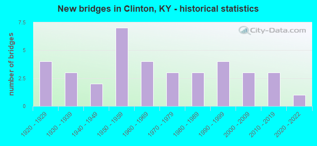
- New bridges - historical statistics
- 41920-1929
- 31930-1939
- 21940-1949
- 71950-1959
- 41960-1969
- 31970-1979
- 31980-1989
- 41990-1999
- 32000-2009
- 32010-2019
- 12020-2022

- Reconstructed bridges - Historical Statistics
- 21990-1999
- 02000-2009
- 12010-2019


- Bridge Condition - Deck
- 21.7%Very good
- 43.5%Good
- 26.1%Satisfactory
- 8.7%Fair

- Bridge Condition - Superstructure
- 30.4%Very good
- 21.7%Good
- 34.8%Satisfactory
- 13.0%Fair

- Bridge Condition - Substructure
- 30.4%Very good
- 21.7%Good
- 39.1%Satisfactory
- 8.7%Fair

- Bridge Condition - Channel
- 3.0%Excellent
- 15.2%Very good
- 36.4%Good
- 33.3%Satisfactory
- 9.1%Fair
- 3.0%Poor

- Bridge Condition - Culverts
- 8.3%Excellent
- 16.7%Good
- 58.3%Satisfactory
- 16.7%Fair
Find on map >> Show street view
Structure Number: 53B00002N, Location: .60 MI SOU. OF JCT KY 288 (Lat: 36.726111, Lng: -89.000000), Route carried "on" structure: US 51, Year Built: 1926, Status: Posted for load, Structure Length: 1.65m (5.41ft), Average Daily Traffic: 1,560 (year 2019), Truck Traffic: 25%, Average Future Daily Traffic: 1,294 (year 2039), Design Load: H 15, Features Intersected: BRUSH CREEK
Minimum Vertical Clearance: 30+ m (98+ ft), Kilometerpoint: 19.179, Lanes on structure: 2, Base Highway Network: Yes, Owner: State Highway Agency, Approaching Roadway Width: 6.1m (20.0ft), Skew: 4 degrees, Material/Design: Concrete, Design/Construction: Tee Beam, Number Of Spans In Main Unit: 1, Length of Maximum Span: 15.2m (49.9ft), Curb-To-Curb Width: 7.9m (25.9ft), Out-to-Out Width: 8.4m (27.6ft)
Condition: Deck: Fair, Superstructure: Fair, Substructure: Fair, Channel: Satisfactory, Operating Rating: 49.8 metric tons, Method Used To Determine Operating Rating: Load Factor (LF), Inventory Rating: 29.8 metric tons, Method Used To Determine Inventory Rating: Load Factor (LF), Structural Evaluation: Somewhat better than minimum adequacy, Deck Geometry: Meets minimum limits, Waterway Adequacy: Equal to present minimum criteria, Approach Roadway Alignment: Equal to present desirable criteria, Bridge Posting: Required (Relationship of Operating Rating to Maximum Legal Load: 10.0 - 19.9% below), Length Of Structure Improvement: 0.16m (0.52ft), Designated Inspection Frequency: Every 24 months, Inspection Date: Febuary 2020, Bridge Improvement Cost: $186,000, Total Project Cost: $185,000, Deck Structure Type: Concrete Cast-file-Place, Wearing Surface/Protective System: Wearing Surface: Bituminous
Find on map >> Show street view
Structure Number: 53B00030N, Location: .10 MI EAST OF JCT KY 239 (Lat: 36.650278, Lng: -89.023889), Route carried "on" structure: State highway 123, Year Built: 1934, Status: Open, Structure Length: 0.70m (2.30ft), Average Daily Traffic: 1,214 (year 2018), Truck Traffic: 25%, Average Future Daily Traffic: 1,068 (year 2038), Design Load: H 15, Features Intersected: BRYARS BRANCH
Minimum Vertical Clearance: 30+ m (98+ ft), Kilometerpoint: 16.018, Lanes on structure: 2, Owner: State Highway Agency, Approaching Roadway Width: 6.1m (20.0ft), Material/Design: Concrete, Design/Construction: Culvert, Number Of Spans In Main Unit: 2, Length of Maximum Span: 3.0m (9.8ft)
Condition: Channel: Satisfactory, Culverts: Satisfactory, Operating Rating: 54.4 metric tons, Method Used To Determine Operating Rating: Field evaluation and documented engineering judgment, Inventory Rating: 40.8 metric tons, Method Used To Determine Inventory Rating: Field evaluation and documented engineering judgment, Structural Evaluation: Equal to present minimum criteria, Waterway Adequacy: Better than present minimum criteria, Approach Roadway Alignment: Equal to present desirable criteria, Designated Inspection Frequency: Every 24 months, Inspection Date: March 2020
Find on map >> Show street view
Structure Number: 53B00031N, Location: .60 MI SOU. OF JCT KY 182 (Lat: 36.654722, Lng: -89.058333), Route carried "on" structure: State highway 123, Year Built: 1934, Status: Open, Structure Length: 0.70m (2.30ft), Average Daily Traffic: 545 (year 2018), Truck Traffic: 15%, Average Future Daily Traffic: 452 (year 2038), Design Load: H 15, Features Intersected: LASTER BRANCH
Minimum Vertical Clearance: 30+ m (98+ ft), Kilometerpoint: 19.616, Lanes on structure: 2, Base Highway Network: Yes, Owner: State Highway Agency, Approaching Roadway Width: 5.5m (18.0ft), Material/Design: Concrete, Design/Construction: Culvert, Number Of Spans In Main Unit: 2, Length of Maximum Span: 3.0m (9.8ft)
Condition: Channel: Good, Culverts: Good, Operating Rating: 54.4 metric tons, Method Used To Determine Operating Rating: Field evaluation and documented engineering judgment, Inventory Rating: 40.8 metric tons, Method Used To Determine Inventory Rating: Field evaluation and documented engineering judgment, Structural Evaluation: Better than present minimum criteria, Waterway Adequacy: Better than present minimum criteria, Approach Roadway Alignment: Equal to present desirable criteria, Designated Inspection Frequency: Every 24 months, Inspection Date: March 2020
Find on map >> Show street view
Structure Number: 53B00038N, Location: .20 MI NOR. OF JCT KY 147 (Lat: 36.690833, Lng: -89.023889), Route carried "on" structure: State highway 58, Year Built: 1927, Status: Open, Structure Length: 2.93m (9.61ft), Average Daily Traffic: 619 (year 2019), Truck Traffic: 10%, Average Future Daily Traffic: 544 (year 2039), Design Load: H 15, Features Intersected: CANE CREEK
Minimum Vertical Clearance: 30+ m (98+ ft), Kilometerpoint: 12.183, Lanes on structure: 2, Owner: State Highway Agency, Approaching Roadway Width: 6.4m (21.0ft), Material/Design: Concrete, Design/Construction: Tee Beam, Number Of Spans In Main Unit: 2, Length of Maximum Span: 13.7m (44.9ft), Curb or Sidewalk Widths: Left: 0.2m (0.7ft), Right: 0.2m (0.7ft), Curb-To-Curb Width: 5.7m (18.7ft), Out-to-Out Width: 6.2m (20.3ft)
Condition: Deck: Satisfactory, Superstructure: Satisfactory, Substructure: Satisfactory, Channel: Good, Operating Rating: 57.2 metric tons, Method Used To Determine Operating Rating: Load Factor (LF), Inventory Rating: 34.3 metric tons, Method Used To Determine Inventory Rating: Load Factor (LF), Structural Evaluation: Equal to present minimum criteria, Deck Geometry: High priority of replacement, Waterway Adequacy: Equal to present minimum criteria, Approach Roadway Alignment: Equal to present desirable criteria, Length Of Structure Improvement: 0.29m (0.95ft), Designated Inspection Frequency: Every 24 months, Inspection Date: Febuary 2020, Bridge Improvement Cost: $246,000, Total Project Cost: $246,000, Deck Structure Type: Concrete Cast-file-Place, Wearing Surface/Protective System: Wearing Surface: Low Slump Concrete
Find on map >> Show street view
Structure Number: 53B00039N, Location: .90 MI NW OF JCT KY 1540 (Lat: 36.719722, Lng: -89.038333), Route carried "on" structure: State highway 58, Year Built: 1931, Year Reconstructed: 2003, Status: Posted for load, Structure Length: 2.97m (9.74ft), Average Daily Traffic: 619 (year 2019), Truck Traffic: 10%, Average Future Daily Traffic: 544 (year 2039), Design Load: H 15, Features Intersected: FORK OF OBION CREEK APPR
Minimum Vertical Clearance: 30+ m (98+ ft), Kilometerpoint: 8.637, Lanes on structure: 2, Owner: State Highway Agency, Approaching Roadway Width: 7.0m (23.0ft), Material/Design: Concrete, Design/Construction: Tee Beam, Number Of Spans In Main Unit: 3, Length of Maximum Span: 9.9m (32.5ft), Curb-To-Curb Width: 7.0m (23.0ft), Out-to-Out Width: 7.9m (25.9ft)
Condition: Deck: Good, Superstructure: Satisfactory, Substructure: Satisfactory, Channel: Good, Operating Rating: 54.2 metric tons, Method Used To Determine Operating Rating: Load Factor (LF), Inventory Rating: 32.5 metric tons, Method Used To Determine Inventory Rating: Load Factor (LF), Structural Evaluation: Equal to present minimum criteria, Deck Geometry: Meets minimum limits, Waterway Adequacy: Equal to present minimum criteria, Approach Roadway Alignment: Equal to present desirable criteria, Bridge Posting: Required (Relationship of Operating Rating to Maximum Legal Load: 20.0 - 29.9% below), Length Of Structure Improvement: 0.30m (0.98ft), Designated Inspection Frequency: Every 24 months, Inspection Date: Febuary 2020, Bridge Improvement Cost: $318,000, Total Project Cost: $318,000, Deck Structure Type: Concrete Cast-file-Place, Wearing Surface/Protective System: Wearing Surface: Latex Concrete
Find on map >> Show street view
Structure Number: 53B00045N, Location: .20 MI SOU. OF JCT KY 123 (Lat: 36.646667, Lng: -89.025556), Route carried "on" structure: State highway 239, Year Built: 1941, Status: Open, Structure Length: 0.70m (2.30ft), Average Daily Traffic: 926 (year 2018), Truck Traffic: 28%, Average Future Daily Traffic: 768 (year 2038), Design Load: H 15, Features Intersected: UNNAME STREAM
Minimum Vertical Clearance: 30+ m (98+ ft), Kilometerpoint: 5.641, Lanes on structure: 2, Base Highway Network: Yes, Owner: State Highway Agency, Approaching Roadway Width: 5.8m (19.0ft), Material/Design: Concrete, Design/Construction: Culvert, Number Of Spans In Main Unit: 2, Length of Maximum Span: 3.0m (9.8ft)
Condition: Channel: Satisfactory, Culverts: Satisfactory, Operating Rating: 54.4 metric tons, Method Used To Determine Operating Rating: Field evaluation and documented engineering judgment, Inventory Rating: 40.8 metric tons, Method Used To Determine Inventory Rating: Field evaluation and documented engineering judgment, Structural Evaluation: Equal to present minimum criteria, Waterway Adequacy: Better than present minimum criteria, Approach Roadway Alignment: Equal to present desirable criteria, Designated Inspection Frequency: Every 24 months, Inspection Date: April 2020
Find on map >> Show street view
Structure Number: 53B00054N, Location: .40 MI N.E. OF JCT US 51S (Lat: 36.638889, Lng: -88.964722), Route carried "on" structure: State highway 780, Year Built: 1950, Status: Open, Structure Length: 0.70m (2.30ft), Average Daily Traffic: 65 (year 2018), Average Future Daily Traffic: 57 (year 2038), Design Load: H 20, Features Intersected: UNNAME STREAM
Minimum Vertical Clearance: 30+ m (98+ ft), Kilometerpoint: 7.458, Lanes on structure: 2, Owner: State Highway Agency, Approaching Roadway Width: 4.9m (16.1ft), Material/Design: Concrete, Design/Construction: Culvert, Number Of Spans In Main Unit: 2, Length of Maximum Span: 3.0m (9.8ft), Curb-To-Curb Width: 4.9m (16.1ft), Out-to-Out Width: 6.5m (21.3ft)
Condition: Channel: Satisfactory, Culverts: Satisfactory, Operating Rating: 54.4 metric tons, Method Used To Determine Operating Rating: Field evaluation and documented engineering judgment, Inventory Rating: 40.8 metric tons, Method Used To Determine Inventory Rating: Field evaluation and documented engineering judgment, Structural Evaluation: Equal to present minimum criteria, Deck Geometry: High priority of corrective action, Waterway Adequacy: Better than present minimum criteria, Approach Roadway Alignment: Equal to present desirable criteria, Designated Inspection Frequency: Every 24 months, Inspection Date: April 2020
Find on map >> Show street view
Structure Number: 53B00057N, Location: 1.4 MI WEST OF JCT US 51 (Lat: 36.611667, Lng: -88.973333), Route carried "on" structure: State highway 1529, Year Built: 1955, Status: Open, Structure Length: 1.07m (3.51ft), Average Daily Traffic: 185 (year 2017), Average Future Daily Traffic: 162 (year 2037), Design Load: H 20, Features Intersected: DRAINAGE DITCH
Minimum Vertical Clearance: 30+ m (98+ ft), Kilometerpoint: 6.223, Lanes on structure: 2, Owner: State Highway Agency, Approaching Roadway Width: 6.1m (20.0ft), Skew: 4 degrees, Material/Design: Concrete, Design/Construction: Culvert, Number Of Spans In Main Unit: 2, Length of Maximum Span: 4.3m (14.1ft), Curb-To-Curb Width: 6.1m (20.0ft), Out-to-Out Width: 7.6m (24.9ft)
Condition: Channel: Fair, Culverts: Satisfactory, Operating Rating: 54.4 metric tons, Method Used To Determine Operating Rating: Field evaluation and documented engineering judgment, Inventory Rating: 40.8 metric tons, Method Used To Determine Inventory Rating: Field evaluation and documented engineering judgment, Structural Evaluation: Equal to present minimum criteria, Deck Geometry: Meets minimum limits, Waterway Adequacy: Better than present minimum criteria, Approach Roadway Alignment: Equal to present desirable criteria, Designated Inspection Frequency: Every 24 months, Inspection Date: Febuary 2020
Find on map >> Show street view
Structure Number: 53B00058N, Location: 1.1 MI WEST OF JCT US 51 (Lat: 36.611944, Lng: -88.967222), Route carried "on" structure: State highway 1529, Year Built: 1955, Status: Posted for load, Structure Length: 1.34m (4.40ft), Average Daily Traffic: 185 (year 2017), Average Future Daily Traffic: 162 (year 2037), Design Load: H 15, Features Intersected: DRAINAGE DITCH
Minimum Vertical Clearance: 30+ m (98+ ft), Kilometerpoint: 6.761, Lanes on structure: 2, Owner: State Highway Agency, Approaching Roadway Width: 6.1m (20.0ft), Skew: 3 degrees, Material/Design: Concrete, Design/Construction: Culvert, Number Of Spans In Main Unit: 2, Length of Maximum Span: 4.3m (14.1ft), Curb or Sidewalk Widths: Left: 0.2m (0.7ft), Right: 0.2m (0.7ft), Curb-To-Curb Width: 7.3m (24.0ft), Out-to-Out Width: 8.6m (28.2ft)
Condition: Channel: Good, Culverts: Fair, Operating Rating: 20.0 metric tons, Method Used To Determine Operating Rating: Field evaluation and documented engineering judgment, Inventory Rating: 18.1 metric tons, Method Used To Determine Inventory Rating: Field evaluation and documented engineering judgment, Structural Evaluation: Somewhat better than minimum adequacy, Deck Geometry: Somewhat better than minimum adequacy, Waterway Adequacy: Better than present minimum criteria, Approach Roadway Alignment: Equal to present desirable criteria, Bridge Posting: Required (Relationship of Operating Rating to Maximum Legal Load: > 39.9% below), Designated Inspection Frequency: Every 24 months, Inspection Date: Febuary 2020
Find on map >> Show street view
Structure Number: 53B00059N, Location: .70 MI WEST OF JCT US 51 (Lat: 36.613611, Lng: -88.960278), Route carried "on" structure: State highway 1529, Year Built: 1955, Status: Open, Structure Length: 7.04m (23.10ft), Average Daily Traffic: 185 (year 2017), Average Future Daily Traffic: 162 (year 2037), Design Load: H 20, Features Intersected: CANE CREEK
Minimum Vertical Clearance: 30+ m (98+ ft), Kilometerpoint: 7.424, Lanes on structure: 2, Owner: State Highway Agency, Approaching Roadway Width: 6.1m (20.0ft), Skew: 4 degrees, Material/Design: Concrete, Design/Construction: Tee Beam, Number Of Spans In Main Unit: 7, Length of Maximum Span: 10.1m (33.1ft), Curb or Sidewalk Widths: Left: 0.6m (2.0ft), Right: 0.6m (2.0ft), Curb-To-Curb Width: 7.3m (24.0ft), Out-to-Out Width: 8.6m (28.2ft)
Condition: Deck: Fair, Superstructure: Good, Substructure: Satisfactory, Channel: Satisfactory, Operating Rating: 75.9 metric tons, Method Used To Determine Operating Rating: Load Factor (LF), Inventory Rating: 45.5 metric tons, Method Used To Determine Inventory Rating: Load Factor (LF), Structural Evaluation: Equal to present minimum criteria, Deck Geometry: Somewhat better than minimum adequacy, Waterway Adequacy: Superior to present desirable criteria, Approach Roadway Alignment: Equal to present minimum criteria, Designated Inspection Frequency: Every 24 months, Inspection Date: Febuary 2020, Deck Structure Type: Concrete Cast-file-Place, Wearing Surface/Protective System: Wearing Surface: Latex Concrete
Find on map >> Show street view
Structure Number: 53B00065N, Location: 1.4 MI N.E. OF JCT US 51 (Lat: 36.688889, Lng: -88.978611), Route carried "on" structure: State highway 703, Year Built: 1956, Status: Open, Structure Length: 2.56m (8.40ft), Average Daily Traffic: 485 (year 2018), Average Future Daily Traffic: 426 (year 2038), Design Load: H 20, Features Intersected: BRANCH OF CANE CREEK
Minimum Vertical Clearance: 30+ m (98+ ft), Kilometerpoint: 2.313, Lanes on structure: 2, Owner: State Highway Agency, Approaching Roadway Width: 6.1m (20.0ft), Material/Design: Concrete, Design/Construction: Tee Beam, Number Of Spans In Main Unit: 3, Length of Maximum Span: 8.5m (27.9ft), Curb or Sidewalk Widths: Left: 0.6m (2.0ft), Right: 0.6m (2.0ft), Curb-To-Curb Width: 7.3m (24.0ft), Out-to-Out Width: 8.6m (28.2ft)
Condition: Deck: Good, Superstructure: Good, Substructure: Good, Channel: Good, Operating Rating: 81.2 metric tons, Method Used To Determine Operating Rating: Load Factor (LF), Inventory Rating: 48.7 metric tons, Method Used To Determine Inventory Rating: Load Factor (LF), Structural Evaluation: Better than present minimum criteria, Deck Geometry: Meets minimum limits, Waterway Adequacy: Superior to present desirable criteria, Approach Roadway Alignment: Equal to present minimum criteria, Designated Inspection Frequency: Every 24 months, Inspection Date: Febuary 2020, Deck Structure Type: Concrete Cast-file-Place, Wearing Surface/Protective System: Wearing Surface: Latex Concrete
Find on map >> Show street view
Structure Number: 53B00066N, Location: 1.0 MI S.W. OF JCT KY 136 (Lat: 36.700000, Lng: -88.960000), Route carried "on" structure: State highway 703, Year Built: 1956, Status: Open, Structure Length: 3.32m (10.89ft), Average Daily Traffic: 485 (year 2018), Average Future Daily Traffic: 426 (year 2038), Design Load: H 20, Features Intersected: BRUSH CREEK
Minimum Vertical Clearance: 30+ m (98+ ft), Kilometerpoint: 4.793, Lanes on structure: 2, Owner: State Highway Agency, Approaching Roadway Width: 6.1m (20.0ft), Skew: 4 degrees, Material/Design: Concrete, Design/Construction: Tee Beam, Number Of Spans In Main Unit: 3, Length of Maximum Span: 16.2m (53.1ft), Curb or Sidewalk Widths: Left: 0.6m (2.0ft), Right: 0.6m (2.0ft), Curb-To-Curb Width: 7.3m (24.0ft), Out-to-Out Width: 8.6m (28.2ft)
Condition: Deck: Satisfactory, Superstructure: Satisfactory, Substructure: Satisfactory, Channel: Good, Operating Rating: 70.1 metric tons, Method Used To Determine Operating Rating: Load Factor (LF), Inventory Rating: 42.1 metric tons, Method Used To Determine Inventory Rating: Load Factor (LF), Structural Evaluation: Equal to present minimum criteria, Deck Geometry: Meets minimum limits, Waterway Adequacy: Superior to present desirable criteria, Approach Roadway Alignment: Equal to present desirable criteria, Designated Inspection Frequency: Every 24 months, Inspection Date: Febuary 2020, Deck Structure Type: Concrete Cast-file-Place, Wearing Surface/Protective System: Wearing Surface: Latex Concrete
Find on map >> Show street view
Structure Number: 53B00072N, Location: 2.2 MI EAST OF JCT US 51 (Lat: 36.669722, Lng: -88.953889), Route carried "on" structure: State highway 123, Year Built: 1961, Status: Posted for load, Structure Length: 3.47m (11.38ft), Average Daily Traffic: 412 (year 2019), Average Future Daily Traffic: 362 (year 2039), Design Load: H 15, Features Intersected: CANE CREEK
Minimum Vertical Clearance: 30+ m (98+ ft), Kilometerpoint: 8.872, Lanes on structure: 2, Owner: State Highway Agency, Approaching Roadway Width: 5.5m (18.0ft), Skew: 3 degrees, Material/Design: Concrete, Design/Construction: Tee Beam, Number Of Spans In Main Unit: 3, Length of Maximum Span: 11.6m (38.1ft), Curb or Sidewalk Widths: Left: 0.6m (2.0ft), Right: 0.6m (2.0ft), Curb-To-Curb Width: 7.3m (24.0ft), Out-to-Out Width: 8.9m (29.2ft)
Condition: Deck: Good, Superstructure: Satisfactory, Substructure: Satisfactory, Channel: Satisfactory, Operating Rating: 56.9 metric tons, Method Used To Determine Operating Rating: Load Factor (LF), Inventory Rating: 34.1 metric tons, Method Used To Determine Inventory Rating: Load Factor (LF), Structural Evaluation: Equal to present minimum criteria, Deck Geometry: Meets minimum limits, Waterway Adequacy: Equal to present desirable criteria, Approach Roadway Alignment: Equal to present desirable criteria, Bridge Posting: Required (Relationship of Operating Rating to Maximum Legal Load: 20.0 - 29.9% below), Designated Inspection Frequency: Every 24 months, Inspection Date: Febuary 2020, Deck Structure Type: Concrete Cast-file-Place, Wearing Surface/Protective System: Wearing Surface: Monolithic Concrete
Find on map >> Show street view
Structure Number: 53B00075N, Location: .15 MI NOR. OF JCT KY 58 (Lat: 36.669722, Lng: -88.993611), Route carried "on" structure: US 51, Year Built: 1927, Status: Open, Structure Length: 0.85m (2.79ft), Average Daily Traffic: 3,976 (year 2020), Average Future Daily Traffic: 3,300 (year 2040), Features Intersected: TOWN BRANCH
Minimum Vertical Clearance: 30+ m (98+ ft), Kilometerpoint: 12.810, Lanes on structure: 2, Base Highway Network: Yes, Owner: State Highway Agency, Approaching Roadway Width: 7.6m (24.9ft), Skew: 1 degrees, Material/Design: Concrete, Design/Construction: Culvert, Number Of Spans In Main Unit: 2, Length of Maximum Span: 3.7m (12.1ft), Curb or Sidewalk Widths: Left: 4.0m (13.1ft), Right: 4.0m (13.1ft), Curb-To-Curb Width: 7.6m (24.9ft), Out-to-Out Width: 17.1m (56.1ft)
Condition: Channel: Satisfactory, Culverts: Satisfactory, Operating Rating: 54.4 metric tons, Method Used To Determine Operating Rating: Field evaluation and documented engineering judgment, Inventory Rating: 39.9 metric tons, Method Used To Determine Inventory Rating: Field evaluation and documented engineering judgment, Structural Evaluation: Equal to present minimum criteria, Deck Geometry: High priority of replacement, Waterway Adequacy: Equal to present minimum criteria, Approach Roadway Alignment: Equal to present desirable criteria, Designated Inspection Frequency: Every 24 months, Inspection Date: Febuary 2020
Find on map >> Show street view
Structure Number: 53B00076N, Location: .20 MI WEST OF JCT US 51 (Lat: 36.666944, Lng: -88.997222), Route carried "on" structure: State highway 58, Year Built: 1963, Status: Open, Structure Length: 2.38m (7.81ft), Average Daily Traffic: 1,687 (year 2015), Truck Traffic: 10%, Average Future Daily Traffic: 1,484 (year 2035), Design Load: H 20, Features Intersected: IC (SOU) RAILROAD
Minimum Vertical Clearance: 30+ m (98+ ft), Kilometerpoint: 16.005, Lanes on structure: 2, Owner: State Highway Agency, Approaching Roadway Width: 8.2m (26.9ft), Material/Design: Concrete, Design/Construction: Culvert, Number Of Spans In Main Unit: 2, Length of Maximum Span: 4.3m (14.1ft), Curb or Sidewalk Widths: Left: 1.2m (3.9ft), Right: 1.5m (4.9ft)
Condition: Channel: Good, Culverts: Satisfactory, Operating Rating: 54.4 metric tons, Method Used To Determine Operating Rating: Field evaluation and documented engineering judgment, Inventory Rating: 40.8 metric tons, Method Used To Determine Inventory Rating: Field evaluation and documented engineering judgment, Structural Evaluation: Equal to present minimum criteria, Waterway Adequacy: Better than present minimum criteria, Approach Roadway Alignment: Equal to present desirable criteria, Designated Inspection Frequency: Every 24 months, Inspection Date: Febuary 2020, Wearing Surface/Protective System: Wearing Surface: Monolithic Concrete
Find on map >> Show street view
Structure Number: 53B00077N, Location: ON WATERFIELD ST N CLINTO (Lat: 36.669167, Lng: -88.992500), Route carried "on" structure: State highway 1731, Year Built: 1956, Status: Open, Structure Length: 0.79m (2.59ft), Average Daily Traffic: 710 (year 2019), Average Future Daily Traffic: 617 (year 2039), Design Load: H 20, Features Intersected: UNNAME STREAM
Minimum Vertical Clearance: 30+ m (98+ ft), Kilometerpoint: 0.439, Lanes on structure: 2, Owner: State Highway Agency, Approaching Roadway Width: 6.1m (20.0ft), Skew: 4 degrees, Material/Design: Concrete, Design/Construction: Culvert, Number Of Spans In Main Unit: 2, Length of Maximum Span: 3.0m (9.8ft), Curb or Sidewalk Widths: Left: 0.2m (0.7ft), Right: 0.2m (0.7ft), Curb-To-Curb Width: 6.1m (20.0ft), Out-to-Out Width: 8.1m (26.6ft)
Condition: Channel: Satisfactory, Culverts: Satisfactory, Operating Rating: 54.4 metric tons, Method Used To Determine Operating Rating: Field evaluation and documented engineering judgment, Inventory Rating: 40.8 metric tons, Method Used To Determine Inventory Rating: Field evaluation and documented engineering judgment, Structural Evaluation: Equal to present minimum criteria, Deck Geometry: High priority of corrective action, Waterway Adequacy: Superior to present desirable criteria, Approach Roadway Alignment: Equal to present desirable criteria, Designated Inspection Frequency: Every 24 months, Inspection Date: Febuary 2020, Wearing Surface/Protective System: Wearing Surface: Bituminous
Find on map >> Show street view
Structure Number: 53B00078N, Location: .30 MI WEST OF JCT KY 58 (Lat: 36.686667, Lng: -89.027222), Route carried "on" structure: State highway 1475, Year Built: 1977, Status: Posted for load, Structure Length: 0.82m (2.69ft), Average Daily Traffic: 129 (year 2020), Average Future Daily Traffic: 112 (year 2040), Features Intersected: HURRICANE BRANCH
Minimum Vertical Clearance: 30+ m (98+ ft), Kilometerpoint: 1.114, Lanes on structure: 2, Owner: State Highway Agency, Approaching Roadway Width: 4.9m (16.1ft), Material/Design: Steel, Design/Construction: Stringer/Multi-beam, Number Of Spans In Main Unit: 1, Length of Maximum Span: 7.6m (24.9ft), Curb-To-Curb Width: 7.0m (23.0ft), Out-to-Out Width: 7.3m (24.0ft)
Condition: Deck: Satisfactory, Superstructure: Satisfactory, Substructure: Satisfactory, Channel: Good, Operating Rating: 58.0 metric tons, Method Used To Determine Operating Rating: Load Factor (LF), Inventory Rating: 34.7 metric tons, Method Used To Determine Inventory Rating: Load Factor (LF), Structural Evaluation: Equal to present minimum criteria, Deck Geometry: Meets minimum limits, Waterway Adequacy: Somewhat better than minimum adequacy, Approach Roadway Alignment: Equal to present desirable criteria, Bridge Posting: Required (Relationship of Operating Rating to Maximum Legal Load: 20.0 - 29.9% below), Designated Inspection Frequency: Every 24 months, Inspection Date: August 2020, Deck Structure Type: Corrugated Steel, Wearing Surface/Protective System: Wearing Surface: Bituminous, Membrane: Preformed Fabric
Find on map >> Show street view
Structure Number: 53B00079N, Location: NTX BLAIR&DEPOT ST-CLINTO (Lat: 36.671111, Lng: -88.997222), Route carried "on" structure: State highway 1826, Year Built: 1979, Year Reconstructed: 2018, Status: Posted for load, Structure Length: 0.91m (2.99ft), Average Daily Traffic: 419 (year 2018), Average Future Daily Traffic: 364 (year 2038), Design Load: H 20, Features Intersected: TOWN CREEK (IN CLINTON)
Minimum Vertical Clearance: 30+ m (98+ ft), Kilometerpoint: 7.963, Lanes on structure: 2, Owner: State Highway Agency, Approaching Roadway Width: 5.8m (19.0ft), Material/Design: Steel, Design/Construction: Stringer/Multi-beam, Number Of Spans In Main Unit: 1, Length of Maximum Span: 8.2m (26.9ft), Curb or Sidewalk Widths: Left: 0.2m (0.7ft), Right: 0.2m (0.7ft), Curb-To-Curb Width: 7.0m (23.0ft), Out-to-Out Width: 7.3m (24.0ft)
Condition: Deck: Satisfactory, Superstructure: Satisfactory, Substructure: Fair, Channel: Good, Operating Rating: 2.8 metric tons, Method Used To Determine Operating Rating: Field evaluation and documented engineering judgment, Inventory Rating: 2.8 metric tons, Method Used To Determine Inventory Rating: Field evaluation and documented engineering judgment, Structural Evaluation: High priority of replacement, Deck Geometry: Meets minimum limits, Waterway Adequacy: Better than present minimum criteria, Approach Roadway Alignment: Meets minimum limits, Bridge Posting: Required (Relationship of Operating Rating to Maximum Legal Load: > 39.9% below), Length Of Structure Improvement: 0.09m (0.30ft), Designated Inspection Frequency: Every 12 months, Inspection Date: September 2021, Bridge Improvement Cost: $108,000, Roadway Improvement Cost: $8,000, Total Project Cost: $116,000, Deck Structure Type: Corrugated Steel, Wearing Surface/Protective System: Wearing Surface: Bituminous
Find on map >> Show street view
Structure Number: 53B00085N, Location: .7 MI.SOU.OF JCT KY 780 (Lat: 36.628611, Lng: -88.964444), Route carried "on" structure: US 51, Year Built: 1982, Status: Open, Structure Length: 3.84m (12.60ft), Average Daily Traffic: 2,926 (year 2015), Truck Traffic: 25%, Average Future Daily Traffic: 2,428 (year 2035), Design Load: HS 20, Features Intersected: BAYOU DE CHIEN CREEK
Minimum Vertical Clearance: 30+ m (98+ ft), Kilometerpoint: 7.252, Lanes on structure: 2, Base Highway Network: Yes, Owner: State Highway Agency, Approaching Roadway Width: 7.3m (24.0ft), Skew: 2 degrees, Material/Design: Prestressed concrete continuous, Design/Construction: Stringer/Multi-beam, Number Of Spans In Main Unit: 3, Length of Maximum Span: 16.2m (53.1ft), Curb-To-Curb Width: 12.1m (39.7ft), Out-to-Out Width: 13.2m (43.3ft)
Condition: Deck: Good, Superstructure: Very good, Substructure: Good, Channel: Good, Operating Rating: 87.2 metric tons, Method Used To Determine Operating Rating: Load Factor (LF), Inventory Rating: 52.3 metric tons, Method Used To Determine Inventory Rating: Load Factor (LF), Structural Evaluation: Better than present minimum criteria, Deck Geometry: Somewhat better than minimum adequacy, Waterway Adequacy: Superior to present desirable criteria, Approach Roadway Alignment: Equal to present desirable criteria, Designated Inspection Frequency: Every 24 months, Inspection Date: October 2021, Deck Structure Type: Concrete Cast-file-Place, Wearing Surface/Protective System: Wearing Surface: Monolithic Concrete, Deck Protection: Epoxy Coated Reinforcing
Find on map >> Show street view
Structure Number: 53B00086N, Location: .5 MI. SOU.OF JCT KY 780 (Lat: 36.628889, Lng: -88.964722), Route carried "on" structure: US 51, Year Built: 1982, Status: Open, Structure Length: 0.82m (2.69ft), Average Daily Traffic: 2,926 (year 2015), Truck Traffic: 25%, Average Future Daily Traffic: 2,428 (year 2035), Design Load: HS 20, Features Intersected: BAYOU DE CHIEN OVERFLOW
Minimum Vertical Clearance: 30+ m (98+ ft), Kilometerpoint: 7.302, Lanes on structure: 2, Base Highway Network: Yes, Owner: State Highway Agency, Approaching Roadway Width: 7.3m (24.0ft), Material/Design: Concrete, Design/Construction: Culvert, Number Of Spans In Main Unit: 2, Length of Maximum Span: 3.7m (12.1ft)
Condition: Channel: Fair, Culverts: Good, Operating Rating: 54.4 metric tons, Method Used To Determine Operating Rating: Field evaluation and documented engineering judgment, Inventory Rating: 32.7 metric tons, Method Used To Determine Inventory Rating: Field evaluation and documented engineering judgment, Structural Evaluation: Better than present minimum criteria, Waterway Adequacy: Superior to present desirable criteria, Approach Roadway Alignment: Equal to present desirable criteria, Designated Inspection Frequency: Every 24 months, Inspection Date: October 2021
Find on map >> Show street view
Structure Number: 53B00095N, Location: 0.1 MI. EAST OF US 51 (Lat: 36.667222, Lng: -88.990278), Route carried "on" structure: State highway 123, Year Built: 1987, Status: Open, Structure Length: 0.85m (2.79ft), Average Daily Traffic: 1,103 (year 2016), Average Future Daily Traffic: 970 (year 2036), Design Load: HS 20, Features Intersected: BRANCH OF SPRING CREEK
Minimum Vertical Clearance: 30+ m (98+ ft), Kilometerpoint: 12.316, Lanes on structure: 2, Owner: State Highway Agency, Approaching Roadway Width: 6.7m (22.0ft), Material/Design: Prestressed concrete, Design/Construction: Box Beam or Girders - Multiple, Number Of Spans In Main Unit: 1, Length of Maximum Span: 8.5m (27.9ft), Curb-To-Curb Width: 7.7m (25.3ft), Out-to-Out Width: 8.2m (26.9ft)
Condition: Deck: Good, Superstructure: Good, Substructure: Good, Channel: Satisfactory, Operating Rating: 74.3 metric tons, Method Used To Determine Operating Rating: Load Factor (LF), Inventory Rating: 44.5 metric tons, Method Used To Determine Inventory Rating: Load Factor (LF), Structural Evaluation: Better than present minimum criteria, Deck Geometry: Meets minimum limits, Waterway Adequacy: Equal to present desirable criteria, Approach Roadway Alignment: Equal to present desirable criteria, Designated Inspection Frequency: Every 24 months, Inspection Date: January 2020, Deck Structure Type: Concrete Precast Panels, Wearing Surface/Protective System: Wearing Surface: Monolithic Concrete
Find on map >> Show street view
Structure Number: 53B00100N, Location: .4 MI. S. JCT US 51 (Lat: 36.649444, Lng: -88.998056), Route carried "on" structure: State highway 780, Year Built: 1999, Status: Open, Structure Length: 6.46m (21.19ft), Average Daily Traffic: 151 (year 2020), Average Future Daily Traffic: 131 (year 2040), Design Load: HS 25 or greater, Features Intersected: CANADIAN NATIONAL RAIL
Minimum Vertical Clearance: 30+ m (98+ ft), Kilometerpoint: 0.991, Lanes on structure: 2, Owner: State Highway Agency, Approaching Roadway Width: 8.2m (26.9ft), Skew: 4 degrees, Material/Design: Prestressed concrete continuous, Design/Construction: Stringer/Multi-beam, Number Of Spans In Main Unit: 3, Length of Maximum Span: 29.0m (95.1ft), Curb-To-Curb Width: 8.4m (27.6ft), Out-to-Out Width: 9.4m (30.8ft)
Condition: Deck: Good, Superstructure: Very good, Substructure: Very good, Operating Rating: 64.0 metric tons, Method Used To Determine Operating Rating: Load Factor (LF), Inventory Rating: 38.4 metric tons, Method Used To Determine Inventory Rating: Load Factor (LF), Structural Evaluation: Equal to present desirable criteria, Deck Geometry: Somewhat better than minimum adequacy, Underclear: Superior to present desirable criteria, Approach Roadway Alignment: Equal to present minimum criteria, Designated Inspection Frequency: Every 24 months, Inspection Date: April 2020, Deck Structure Type: Concrete Cast-file-Place, Wearing Surface/Protective System: Wearing Surface: Monolithic Concrete, Deck Protection: Epoxy Coated Reinforcing
Find on map >> Show street view
Structure Number: 53B00101N, Location: .4 MI.5 JCT KY 1540 (Lat: 36.696389, Lng: -89.000556), Route carried "on" structure: US 51, Year Built: 2000, Status: Open, Structure Length: 2.38m (7.81ft), Average Daily Traffic: 1,560 (year 2019), Truck Traffic: 25%, Average Future Daily Traffic: 1,294 (year 2039), Design Load: HS 25 or greater, Features Intersected: CANE CREEK
Minimum Vertical Clearance: 30+ m (98+ ft), Kilometerpoint: 15.912, Lanes on structure: 2, Base Highway Network: Yes, Owner: State Highway Agency, Approaching Roadway Width: 13.1m (43.0ft), Material/Design: Prestressed concrete, Design/Construction: Box Beam or Girders - Multiple, Number Of Spans In Main Unit: 1, Length of Maximum Span: 23.5m (77.1ft), Curb-To-Curb Width: 13.1m (43.0ft), Out-to-Out Width: 13.6m (44.6ft)
Condition: Deck: Good, Superstructure: Very good, Substructure: Very good, Channel: Good, Operating Rating: 78.7 metric tons, Method Used To Determine Operating Rating: Load Factor (LF), Inventory Rating: 47.2 metric tons, Method Used To Determine Inventory Rating: Load Factor (LF), Structural Evaluation: Equal to present desirable criteria, Deck Geometry: Better than present minimum criteria, Waterway Adequacy: Equal to present desirable criteria, Approach Roadway Alignment: Equal to present desirable criteria, Designated Inspection Frequency: Every 24 months, Inspection Date: Febuary 2020, Deck Structure Type: Concrete Cast-file-Place, Wearing Surface/Protective System: Wearing Surface: Monolithic Concrete, Deck Protection: Epoxy Coated Reinforcing
Find on map >> Show street view
Structure Number: 53B00104N, Location: .2 MI WEST OF JCT US 51 (Lat: 36.635556, Lng: -88.976111), Route carried "on" structure: State highway 780, Year Built: 1964, Year Reconstructed: 2003, Status: Posted for load, Structure Length: 1.07m (3.51ft), Average Daily Traffic: 151 (year 2020), Average Future Daily Traffic: 131 (year 2040), Design Load: H 20, Features Intersected: OVER BAYOU DE CHIEN
Minimum Vertical Clearance: 30+ m (98+ ft), Kilometerpoint: 6.144, Lanes on structure: 2, Owner: State Highway Agency, Approaching Roadway Width: 7.3m (24.0ft), Material/Design: Steel, Design/Construction: Stringer/Multi-beam, Number Of Spans In Main Unit: 1, Length of Maximum Span: 9.8m (32.2ft), Curb-To-Curb Width: 7.3m (24.0ft), Out-to-Out Width: 7.8m (25.6ft)
Condition: Deck: Satisfactory, Superstructure: Satisfactory, Substructure: Satisfactory, Channel: Very good, Operating Rating: 43.8 metric tons, Method Used To Determine Operating Rating: Load Factor (LF), Inventory Rating: 26.3 metric tons, Method Used To Determine Inventory Rating: Load Factor (LF), Structural Evaluation: Equal to present minimum criteria, Deck Geometry: Somewhat better than minimum adequacy, Waterway Adequacy: Equal to present desirable criteria, Approach Roadway Alignment: Equal to present desirable criteria, Bridge Posting: Required (Relationship of Operating Rating to Maximum Legal Load: 30.0 - 39.9% below), Designated Inspection Frequency: Every 24 months, Inspection Date: April 2020, Deck Structure Type: Corrugated Steel, Wearing Surface/Protective System: Wearing Surface: Bituminous
Find on map >> Show street view
Structure Number: 53B00105N, Location: 2.508 miles S. KY HWY 288 (Lat: 36.715000, Lng: -88.981667), Route carried "on" structure: State highway 2206, Year Built: 2009, Status: Open, Structure Length: 2.69m (8.83ft), Average Daily Traffic: 98 (year 2020), Average Future Daily Traffic: 85 (year 2040), Design Load: HS 25 or greater, Features Intersected: Brush Creek
Minimum Vertical Clearance: 30+ m (98+ ft), Kilometerpoint: 3.544, Lanes on structure: 2, Owner: State Highway Agency, Approaching Roadway Width: 7.9m (25.9ft), Skew: 4 degrees, Material/Design: Prestressed concrete, Design/Construction: Stringer/Multi-beam, Number Of Spans In Main Unit: 1, Length of Maximum Span: 25.6m (84.0ft), Curb or Sidewalk Widths: Left: 0.5m (1.6ft), Right: 0.5m (1.6ft), Curb-To-Curb Width: 7.3m (24.0ft), Out-to-Out Width: 7.6m (24.9ft)
Condition: Deck: Very good, Superstructure: Fair, Substructure: Very good, Channel: Very good, Operating Rating: 94.7 metric tons, Method Used To Determine Operating Rating: Load Factor (LF), Inventory Rating: 56.8 metric tons, Method Used To Determine Inventory Rating: Load Factor (LF), Structural Evaluation: Somewhat better than minimum adequacy, Deck Geometry: Equal to present minimum criteria, Waterway Adequacy: Better than present minimum criteria, Approach Roadway Alignment: Equal to present minimum criteria, Designated Inspection Frequency: Every 24 months, Inspection Date: June 2021, Deck Structure Type: Concrete Cast-file-Place, Wearing Surface/Protective System: Wearing Surface: Monolithic Concrete, Deck Protection: Epoxy Coated Reinforcing
Find on map >> Show street view
Structure Number: 53B00106N, Location: 2.1 miles North of KY 703 (Lat: 36.715556, Lng: -88.981667), Route carried "on" structure: State highway 2206, Year Built: 2009, Status: Open, Structure Length: 1.37m (4.49ft), Average Daily Traffic: 98 (year 2020), Average Future Daily Traffic: 85 (year 2040), Design Load: HS 25 or greater, Features Intersected: Branch of Brush Creek
Minimum Vertical Clearance: 30+ m (98+ ft), Kilometerpoint: 3.610, Lanes on structure: 2, Owner: State Highway Agency, Approaching Roadway Width: 7.3m (24.0ft), Material/Design: Prestressed concrete, Design/Construction: Stringer/Multi-beam, Number Of Spans In Main Unit: 1, Length of Maximum Span: 12.8m (42.0ft), Curb or Sidewalk Widths: Left: 0.5m (1.6ft), Right: 0.5m (1.6ft), Curb-To-Curb Width: 7.6m (24.9ft), Out-to-Out Width: 8.6m (28.2ft)
Condition: Deck: Very good, Superstructure: Very good, Substructure: Very good, Channel: Very good, Operating Rating: 86.7 metric tons, Method Used To Determine Operating Rating: Load Factor (LF), Inventory Rating: 52.1 metric tons, Method Used To Determine Inventory Rating: Load Factor (LF), Structural Evaluation: Equal to present desirable criteria, Deck Geometry: Equal to present minimum criteria, Waterway Adequacy: Equal to present minimum criteria, Approach Roadway Alignment: Equal to present minimum criteria, Designated Inspection Frequency: Every 24 months, Inspection Date: Febuary 2020, Deck Structure Type: Concrete Cast-file-Place, Wearing Surface/Protective System: Wearing Surface: Monolithic Concrete, Deck Protection: Epoxy Coated Reinforcing
Find on map >> Show street view
Structure Number: 53B00107N, Location: OVER C&N RAILWAY (Lat: 36.654444, Lng: -88.998889), Route carried "on" structure: State highway 1037, Year Built: 2013, Status: Open, Structure Length: 5.73m (18.80ft), Average Daily Traffic: 527 (year 2019), Average Future Daily Traffic: 458 (year 2039), Design Load: Greater than HL93, Features Intersected: C&N RAILWAY
Minimum Vertical Clearance: 30.18m (99.02ft), Kilometerpoint: 0.771, Lanes on structure: 2, Owner: State Highway Agency, Approaching Roadway Width: 7.9m (25.9ft), Material/Design: Prestressed concrete continuous, Design/Construction: Stringer/Multi-beam, Number Of Spans In Main Unit: 3, Length of Maximum Span: 25.6m (84.0ft), Curb-To-Curb Width: 7.9m (25.9ft), Out-to-Out Width: 8.8m (28.9ft)
Condition: Deck: Very good, Superstructure: Very good, Substructure: Very good, Operating Rating: 58.3 metric tons, Method Used To Determine Operating Rating: Load and Resistance Factor Rating (LRFR) rating reported by rating factor(RF) method using HL-93 loadings, Inventory Rating: 44.7 metric tons, Method Used To Determine Inventory Rating: Load and Resistance Factor Rating (LRFR) rating reported by rating factor(RF) method using HL-93 loadings, Structural Evaluation: Equal to present desirable criteria, Deck Geometry: Somewhat better than minimum adequacy, Underclear: Superior to present desirable criteria, Approach Roadway Alignment: Equal to present minimum criteria, Designated Inspection Frequency: Every 24 months, Inspection Date: September 2021, Deck Structure Type: Concrete Cast-file-Place, Wearing Surface/Protective System: Wearing Surface: Monolithic Concrete, Deck Protection: Epoxy Coated Reinforcing
Find on map >> Show street view
Structure Number: 53B00111N, Location: .6 MI N of KY 703 (Lat: 36.693889, Lng: -88.986944), Route carried "on" structure: State highway 2206, Year Built: 2019, Status: Open, Structure Length: 3.22m (10.56ft), Average Daily Traffic: 98 (year 2020), Average Future Daily Traffic: 85 (year 2040), Design Load: Greater than HL93, Features Intersected: Cane Crd Fk - Obion Crk
Minimum Vertical Clearance: 30+ m (98+ ft), Kilometerpoint: 1.078, Lanes on structure: 2, Owner: State Highway Agency, Approaching Roadway Width: 5.5m (18.0ft), Material/Design: Prestressed concrete, Design/Construction: Box Beam or Girders - Multiple, Number Of Spans In Main Unit: 3, Length of Maximum Span: 13.4m (44.0ft), Curb-To-Curb Width: 6.9m (22.6ft), Out-to-Out Width: 7.3m (24.0ft)
Condition: Deck: Very good, Superstructure: Very good, Substructure: Very good, Channel: Very good, Operating Rating: 47.6 metric tons, Method Used To Determine Operating Rating: Load and Resistance Factor Rating (LRFR) rating reported by rating factor(RF) method using HL-93 loadings, Inventory Rating: 36.6 metric tons, Method Used To Determine Inventory Rating: Load and Resistance Factor Rating (LRFR) rating reported by rating factor(RF) method using HL-93 loadings, Structural Evaluation: Equal to present desirable criteria, Deck Geometry: Somewhat better than minimum adequacy, Waterway Adequacy: Equal to present minimum criteria, Approach Roadway Alignment: Equal to present desirable criteria, Designated Inspection Frequency: Every 24 months, Inspection Date: June 2021, Deck Structure Type: Concrete Cast-file-Place, Wearing Surface/Protective System: Wearing Surface: Monolithic Concrete, Deck Protection: Epoxy Coated Reinforcing
Find on map >> Show street view
Structure Number: 53B00113N, Location: .3 miles North KY 58 (Lat: 36.653333, Lng: -88.931389), Route carried "on" structure: State highway 2208, Year Built: 2020, Status: Open, Structure Length: 0.73m (2.40ft), Average Daily Traffic: 107 (year 2019), Average Future Daily Traffic: 93 (year 2039), Design Load: Greater than HL93, Features Intersected: Unknown
Minimum Vertical Clearance: 30+ m (98+ ft), Kilometerpoint: 0.417, Lanes on structure: 2, Owner: State Highway Agency, Approaching Roadway Width: 6.1m (20.0ft), Material/Design: Aluminum, Iron, Design/Construction: Culvert, Number Of Spans In Main Unit: 1, Length of Maximum Span: 7.3m (24.0ft)
Condition: Channel: Excellent, Culverts: Excellent, Operating Rating: 55.7 metric tons, Method Used To Determine Operating Rating: Load and Resistance Factor Rating (LRFR) rating reported by rating factor(RF) method using HL-93 loadings, Inventory Rating: 42.8 metric tons, Method Used To Determine Inventory Rating: Load and Resistance Factor Rating (LRFR) rating reported by rating factor(RF) method using HL-93 loadings, Structural Evaluation: Superior to present desirable criteria, Waterway Adequacy: Equal to present desirable criteria, Approach Roadway Alignment: Equal to present desirable criteria, Designated Inspection Frequency: Every 24 months, Inspection Date: November 2020
Find on map >> Show street view
Structure Number: 53C00009N, Location: .2 MI S OF JCT KY 944 (Lat: 36.627500, Lng: -88.844167), Route carried "on" structure: County highway 1110, Year Built: 1977, Status: Posted for load, Structure Length: 0.73m (2.40ft), Average Daily Traffic: 30 (year 2019), Average Future Daily Traffic: 26 (year 2039), Features Intersected: SAND CREEK, Facility Carried by Structure: JACKSON CHAPEL ROA
Minimum Vertical Clearance: 30+ m (98+ ft), Kilometerpoint: 0.174, Lanes on structure: 1, Owner: County Highway Agency, Approaching Roadway Width: 4.9m (16.1ft), Material/Design: Steel, Design/Construction: Culvert, Number Of Spans In Main Unit: 3, Length of Maximum Span: 1.8m (5.9ft)
Condition: Channel: Poor, Culverts: Fair, Operating Rating: 86.5 metric tons, Method Used To Determine Operating Rating: Load and Resistance Factor Rating (LRFR) rating reported by rating factor(RF) method using HL-93 loadings, Inventory Rating: 66.7 metric tons, Method Used To Determine Inventory Rating: Load and Resistance Factor Rating (LRFR) rating reported by rating factor(RF) method using HL-93 loadings, Structural Evaluation: Somewhat better than minimum adequacy, Waterway Adequacy: Meets minimum limits, Approach Roadway Alignment: Equal to present minimum criteria, Designated Inspection Frequency: Every 24 months, Inspection Date: Febuary 2020
Find on map >> Show street view
Structure Number: 53C00038N, Location: 300' S OF DEPOT ST. (Lat: 36.670000, Lng: -88.994722), Route carried "on" structure: City street 1052, Year Built: 1940, Status: Posted for load, Structure Length: 0.70m (2.30ft), Average Daily Traffic: 545 (year 2006), Average Future Daily Traffic: 2,026 (year 2026), Features Intersected: BR OF CANE CREEK, Facility Carried by Structure: JEFFERSON STREET
Minimum Vertical Clearance: 30+ m (98+ ft), Kilometerpoint: 0.325, Lanes on structure: 2, Owner: City or Municipal Highway Agency, Approaching Roadway Width: 7.0m (23.0ft), Material/Design: Steel, Design/Construction: Stringer/Multi-beam, Number Of Spans In Main Unit: 1, Length of Maximum Span: 7.0m (23.0ft), Curb or Sidewalk Widths: Left: 1.8m (5.9ft), Right: 0.0m, Curb-To-Curb Width: 7.1m (23.3ft), Out-to-Out Width: 9.1m (29.9ft)
Condition: Deck: Good, Superstructure: Fair, Substructure: Satisfactory, Channel: Good, Operating Rating: 10.9 metric tons, Method Used To Determine Operating Rating: Field evaluation and documented engineering judgment, Inventory Rating: 10.9 metric tons, Method Used To Determine Inventory Rating: Field evaluation and documented engineering judgment, Structural Evaluation: High priority of corrective action, Deck Geometry: Meets minimum limits, Waterway Adequacy: Somewhat better than minimum adequacy, Approach Roadway Alignment: Equal to present minimum criteria, Bridge Posting: Required (Relationship of Operating Rating to Maximum Legal Load: > 39.9% below), Designated Inspection Frequency: Every 12 months, Inspection Date: Febuary 2021, Deck Structure Type: Concrete Cast-file-Place, Wearing Surface/Protective System: Wearing Surface: Bituminous
Find on map >> Show street view
Structure Number: 53C00055N, Location: 1.5 MI W. US 51 (Lat: 36.725000, Lng: -89.019444), Route carried "on" structure: County highway 1301, Year Built: 1990, Status: Posted for load, Structure Length: 1.10m (3.61ft), Average Daily Traffic: 16 (year 2006), Average Future Daily Traffic: 2,026 (year 2026), Design Load: HS 20, Features Intersected: BR OBION CR, Facility Carried by Structure: HARPER ROAD
Minimum Vertical Clearance: 30+ m (98+ ft), Kilometerpoint: 0.681, Lanes on structure: 2, Owner: County Highway Agency, Approaching Roadway Width: 5.5m (18.0ft), Material/Design: Wood or Timber, Design/Construction: Stringer/Multi-beam, Number Of Spans In Main Unit: 1, Length of Maximum Span: 10.7m (35.1ft), Curb or Sidewalk Widths: Left: 0.2m (0.7ft), Right: 0.2m (0.7ft), Curb-To-Curb Width: 5.5m (18.0ft), Out-to-Out Width: 5.9m (19.4ft)
Condition: Deck: Satisfactory, Superstructure: Satisfactory, Substructure: Satisfactory, Channel: Satisfactory, Operating Rating: 52.4 metric tons, Method Used To Determine Operating Rating: Allowable Stress (AS), Inventory Rating: 35.7 metric tons, Method Used To Determine Inventory Rating: Allowable Stress (AS), Structural Evaluation: Equal to present minimum criteria, Deck Geometry: Meets minimum limits, Waterway Adequacy: Equal to present minimum criteria, Approach Roadway Alignment: Meets minimum limits, Bridge Posting: Required (Relationship of Operating Rating to Maximum Legal Load: 30.0 - 39.9% below), Length Of Structure Improvement: 0.11m (0.36ft), Designated Inspection Frequency: Every 24 months, Inspection Date: Febuary 2021, Bridge Improvement Cost: $88,000, Total Project Cost: $87,000, Deck Structure Type: Wood or Timber, Wearing Surface/Protective System: Wearing Surface: Bituminous
Find on map >> Show street view
Structure Number: 53C00058N, Location: .4 MI N - KY 58 (Lat: 36.656111, Lng: -88.941389), Route carried "on" structure: County highway 1100, Year Built: 1992, Status: Posted for load, Structure Length: 1.34m (4.40ft), Average Daily Traffic: 10 (year 2019), Average Future Daily Traffic: 8 (year 2039), Design Load: HS 20, Features Intersected: CANE CK FK-OBION CREEK, Facility Carried by Structure: HATCH ROAD
Minimum Vertical Clearance: 30+ m (98+ ft), Kilometerpoint: 0.558, Lanes on structure: 2, Owner: County Highway Agency, Approaching Roadway Width: 3.0m (9.8ft), Material/Design: Prestressed concrete, Design/Construction: Box Beam or Girders - Multiple, Number Of Spans In Main Unit: 1, Length of Maximum Span: 12.8m (42.0ft), Curb or Sidewalk Widths: Left: 0.2m (0.7ft), Right: 0.2m (0.7ft), Curb-To-Curb Width: 5.7m (18.7ft), Out-to-Out Width: 6.2m (20.3ft)
Condition: Deck: Good, Superstructure: Good, Substructure: Good, Channel: Fair, Operating Rating: 54.4 metric tons, Method Used To Determine Operating Rating: Load Factor (LF), Inventory Rating: 32.7 metric tons, Method Used To Determine Inventory Rating: Load Factor (LF), Structural Evaluation: Better than present minimum criteria, Deck Geometry: Meets minimum limits, Waterway Adequacy: Better than present minimum criteria, Approach Roadway Alignment: Equal to present minimum criteria, Bridge Posting: Required (Relationship of Operating Rating to Maximum Legal Load: > 39.9% below), Designated Inspection Frequency: Every 24 months, Inspection Date: Febuary 2020, Deck Structure Type: Concrete Precast Panels, Wearing Surface/Protective System: Wearing Surface: Monolithic Concrete
Find on map >> Show street view
Structure Number: 53C00061N, Location: .2 MI E. JCT BLACK RD (Lat: 36.691667, Lng: -88.940000), Route carried "on" structure: County highway 1004, Year Built: 1995, Status: Posted for load, Structure Length: 1.10m (3.61ft), Average Daily Traffic: 13 (year 2019), Average Future Daily Traffic: 11 (year 2039), Design Load: HS 25 or greater, Features Intersected: BRUSH CREEK, Facility Carried by Structure: SWEEZY ROAD
Minimum Vertical Clearance: 30+ m (98+ ft), Kilometerpoint: 0.729, Lanes on structure: 2, Owner: County Highway Agency, Approaching Roadway Width: 3.7m (12.1ft), Material/Design: Prestressed concrete, Design/Construction: Box Beam or Girders - Multiple, Number Of Spans In Main Unit: 1, Length of Maximum Span: 10.4m (34.1ft), Curb or Sidewalk Widths: Left: 0.2m (0.7ft), Right: 0.2m (0.7ft), Curb-To-Curb Width: 5.7m (18.7ft), Out-to-Out Width: 6.2m (20.3ft)
Condition: Deck: Good, Superstructure: Good, Substructure: Good, Channel: Satisfactory, Operating Rating: 51.1 metric tons, Method Used To Determine Operating Rating: Load Factor (LF), Inventory Rating: 30.7 metric tons, Method Used To Determine Inventory Rating: Load Factor (LF), Structural Evaluation: Better than present minimum criteria, Deck Geometry: Meets minimum limits, Waterway Adequacy: Better than present minimum criteria, Approach Roadway Alignment: Equal to present minimum criteria, Bridge Posting: Required (Relationship of Operating Rating to Maximum Legal Load: 0.1 - 9.9% below), Designated Inspection Frequency: Every 24 months, Inspection Date: Febuary 2021, Deck Structure Type: Concrete Precast Panels, Wearing Surface/Protective System: Wearing Surface: Monolithic Concrete
Find on map >> Show street view
Structure Number: 53C00069N, Location: 0.08 MI S. OF KY 1826 (Lat: 36.669722, Lng: -88.995833), Route carried "on" structure: City street 1035, Year Built: 2012, Status: Open, Structure Length: 1.55m (5.09ft), Average Daily Traffic: 545 (year 2012), Average Future Daily Traffic: 2,032 (year 2032), Design Load: Greater than HL93, Features Intersected: CANE CREEK
Minimum Vertical Clearance: 30+ m (98+ ft), Kilometerpoint: 0.142, Lanes on structure: 2, Owner: City or Municipal Highway Agency, Approaching Roadway Width: 5.5m (18.0ft), Material/Design: Prestressed concrete, Design/Construction: Box Beam or Girders - Single/Spread, Number Of Spans In Main Unit: 1, Length of Maximum Span: 14.6m (47.9ft), Curb-To-Curb Width: 6.7m (22.0ft), Out-to-Out Width: 6.7m (22.0ft)
Condition: Deck: Very good, Superstructure: Very good, Substructure: Very good, Channel: Very good, Operating Rating: 70.3 metric tons, Method Used To Determine Operating Rating: Load and Resistance Factor Rating (LRFR) rating reported by rating factor(RF) method using HL-93 loadings, Inventory Rating: 54.4 metric tons, Method Used To Determine Inventory Rating: Load and Resistance Factor Rating (LRFR) rating reported by rating factor(RF) method using HL-93 loadings, Structural Evaluation: Equal to present desirable criteria, Deck Geometry: Meets minimum limits, Waterway Adequacy: Equal to present minimum criteria, Approach Roadway Alignment: Equal to present desirable criteria, Designated Inspection Frequency: Every 24 months, Inspection Date: Febuary 2021, Deck Structure Type: Concrete Cast-file-Place, Wearing Surface/Protective System: Wearing Surface: Monolithic Concrete, Deck Protection: Epoxy Coated Reinforcing
Find on map >> Show street view
Structure Number: 53R00600N, Location: .15 MI WEST OF JCT US 51 (Lat: 36.666944, Lng: -88.997500), Route carried "under" structure: State highway 58, Year Built: 1960, Structure Length: 0. m, Average Daily Traffic: 1,687 (year 2015), Truck Traffic: 10%, Features Intersected: KY 58, Facility Carried by Structure: C & N Railway
Minimum Vertical Clearance: 4.44m (14.57ft), Kilometerpoint: 15.986, Lanes under structure: 2, Material/Design: Steel, Design/Construction: Stringer/Multi-beam, Length of Maximum Span: 16.8m (55.1ft)
Find on map >> Show street view
Structure Number: 53R00612N, Location: .2 MI W OF US 51 (Lat: 36.671111, Lng: -88.997222), Route carried "under" structure: State highway 1826, Year Built: 1920, Structure Length: 0. m, Average Daily Traffic: 419 (year 2018), Features Intersected: KY1826, Facility Carried by Structure: C/N (SOU) RAILROAD
Minimum Vertical Clearance: 2.20m (7.22ft), Kilometerpoint: 7.978, Lanes under structure: 2, Material/Design: Wood or Timber, Design/Construction: Stringer/Multi-beam, Length of Maximum Span: 4.0m (13.1ft)