Bridge Statistics for Clifton Park, New York (NY)
Condition, Traffic, Stress, Structural Evaluation, Project Costs
- National Bridge Inventory (NBI) Statistics
- 27Number of bridges
- 266ft / 81.1mTotal length
- $42,889,000Total costs
- 555,211Total average daily traffic
- 32,040Total average daily truck traffic
- National Bridge Inventory (NBI) Registered Bridges for Clifton Park
- No street view available for this location
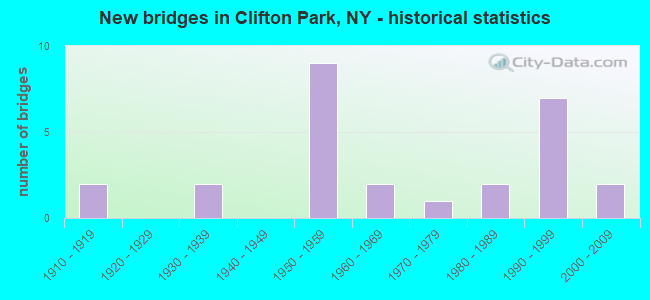
- New bridges - historical statistics
- 21910-1919
- 21930-1939
- 91950-1959
- 21960-1969
- 11970-1979
- 21980-1989
- 71990-1999
- 22000-2009

- Reconstructed bridges - Historical Statistics
- 21970-1979
- 11980-1989
- 11990-1999


- Bridge Condition - Deck
- 7.1%Excellent
- 21.4%Very good
- 28.6%Good
- 42.9%Satisfactory

- Bridge Condition - Superstructure
- 7.1%Excellent
- 35.7%Very good
- 42.9%Good
- 14.3%Fair

- Bridge Condition - Substructure
- 35.7%Very good
- 28.6%Good
- 21.4%Satisfactory
- 7.1%Fair
- 7.1%Poor

- Bridge Condition - Channel
- 28.6%Satisfactory
- 71.4%Fair

- Bridge Condition - Culverts
- 33.3%Good
- 66.7%Satisfactory
Find on map >> Show street view
Structure Number: 100559, Location: RT 9 2.7 MI S OF ROUND LK (Lat: 42.902836, Lng: -73.774242), Route carried "on" structure: US 9, Year Built: 1960, Status: Open, Structure Length: 1.01m (3.31ft), Average Daily Traffic: 12,357 (year 2019), Truck Traffic: 7%, Average Future Daily Traffic: 12,415 (year 2040), Features Intersected: DWAAS KILL
Minimum Vertical Clearance: 30+ m (98+ ft), Kilometerpoint: 10.185, Lanes on structure: 4, Base Highway Network: Yes, Owner: State Highway Agency, Approaching Roadway Width: 22.6m (74.1ft), Skew: 20 degrees, Material/Design: Concrete continuous, Design/Construction: Culvert, Number Of Spans In Main Unit: 2, Length of Maximum Span: 4.8m (15.7ft)
Condition: Channel: Fair, Culverts: Good, Operating Rating: 66.2 metric tons, Method Used To Determine Operating Rating: Load Factor (LF), Inventory Rating: 39.0 metric tons, Method Used To Determine Inventory Rating: Load Factor (LF), Structural Evaluation: Better than present minimum criteria, Waterway Adequacy: Superior to present desirable criteria, Approach Roadway Alignment: Equal to present desirable criteria, Length Of Structure Improvement: 1.00m (3.28ft), Designated Inspection Frequency: Every 24 months, Inspection Date: August 2020, Bridge Improvement Cost: $836,000, Roadway Improvement Cost: $490,000, Total Project Cost: $1,326,000 ( Estimate for 2021), Wearing Surface/Protective System: Wearing Surface: Bituminous
Find on map >> Show street view
Structure Number: 1032851, Location: Route I-87 Exit 9 (Lat: 42.862389, Lng: -73.775428), Route carried "on" structure: Interstate 87, Year Built: 1958, Year Reconstructed: 1978, Status: Open, Structure Length: 4.91m (16.11ft), Average Daily Traffic: 40,663 (year 2006), Truck Traffic: 9%, Design Load: H 20, Features Intersected: RTE 146
Minimum Vertical Clearance: 30+ m (98+ ft), Kilometerpoint: 7.965, Lanes on structure: 4, Lanes under structure: 5, Base Highway Network: Yes, Owner: State Highway Agency, Approaching Roadway Width: 18.9m (62.0ft), Material/Design: Steel, Design/Construction: Stringer/Multi-beam, Number Of Spans In Main Unit: 3, Length of Maximum Span: 26.8m (87.9ft), Curb-To-Curb Width: 18.0m (59.1ft), Out-to-Out Width: 18.9m (62.0ft)
Condition: Deck: Satisfactory, Superstructure: Good, Substructure: Good, Operating Rating: 63.5 metric tons, Method Used To Determine Operating Rating: Load Factor (LF), Inventory Rating: 38.1 metric tons, Method Used To Determine Inventory Rating: Load Factor (LF), Structural Evaluation: Better than present minimum criteria, Deck Geometry: Meets minimum limits, Underclear: High priority of corrective action, Approach Roadway Alignment: Equal to present desirable criteria, Length Of Structure Improvement: 4.90m (16.08ft), Designated Inspection Frequency: Every 24 months, Inspection Date: July 2021, Bridge Improvement Cost: $2,057,000, Roadway Improvement Cost: $1,205,000, Total Project Cost: $3,262,000 ( Estimate for 2021), Deck Structure Type: Concrete Cast-file-Place, Wearing Surface/Protective System: Wearing Surface: Integral Concrete, Deck Protection: Epoxy Coated Reinforcing
Find on map >> Show street view
Structure Number: 1032852, Location: Route I-87 Exit 9 (Lat: 42.862383, Lng: -73.775167), Route carried "on" structure: Interstate 87, Year Built: 1958, Year Reconstructed: 1978, Status: Open, Structure Length: 4.91m (16.11ft), Average Daily Traffic: 33,359 (year 2018), Truck Traffic: 18%, Average Future Daily Traffic: 52,864 (year 2040), Design Load: H 20, Features Intersected: RTE 146
Minimum Vertical Clearance: 30+ m (98+ ft), Kilometerpoint: 7.965, Lanes on structure: 4, Lanes under structure: 5, Base Highway Network: Yes, Owner: State Highway Agency, Approaching Roadway Width: 19.2m (63.0ft), Material/Design: Steel, Design/Construction: Stringer/Multi-beam, Number Of Spans In Main Unit: 3, Length of Maximum Span: 26.8m (87.9ft), Curb-To-Curb Width: 18.0m (59.1ft), Out-to-Out Width: 18.9m (62.0ft)
Condition: Deck: Satisfactory, Superstructure: Good, Substructure: Good, Operating Rating: 63.5 metric tons, Method Used To Determine Operating Rating: Load Factor (LF), Inventory Rating: 38.1 metric tons, Method Used To Determine Inventory Rating: Load Factor (LF), Structural Evaluation: Better than present minimum criteria, Deck Geometry: Meets minimum limits, Underclear: High priority of corrective action, Approach Roadway Alignment: Equal to present desirable criteria, Length Of Structure Improvement: 4.90m (16.08ft), Designated Inspection Frequency: Every 24 months, Inspection Date: July 2021, Bridge Improvement Cost: $2,057,000, Roadway Improvement Cost: $1,205,000, Total Project Cost: $3,262,000 ( Estimate for 2021), Deck Structure Type: Concrete Cast-file-Place, Wearing Surface/Protective System: Wearing Surface: Integral Concrete, Deck Protection: Epoxy Coated Reinforcing
Find on map >> Show street view
Structure Number: 10332, Location: JCT I87 & COUNTY ROAD 91 (Lat: 42.840092, Lng: -73.772061), Route carried "on" structure: County highway , Year Built: 1993, Status: Open, Structure Length: 10.79m (35.40ft), Average Daily Traffic: 13,277 (year 2017), Truck Traffic: 3%, Average Future Daily Traffic: 16,128 (year 2040), Design Load: HS 20, Features Intersected: 87I 87I15091034, RTE I87, Facility Carried by Structure: GROOMS ROAD
Minimum Vertical Clearance: 30+ m (98+ ft), Kilometerpoint: 10.893, Lanes on structure: 3, Lanes under structure: 6, Owner: State Highway Agency, Approaching Roadway Width: 14.6m (47.9ft), Material/Design: Steel continuous, Design/Construction: Stringer/Multi-beam, Number Of Spans In Main Unit: 2, Length of Maximum Span: 53.6m (175.9ft), Curb-To-Curb Width: 14.3m (46.9ft), Out-to-Out Width: 15.2m (49.9ft)
Condition: Deck: Good, Superstructure: Very good, Substructure: Very good, Operating Rating: 56.2 metric tons, Method Used To Determine Operating Rating: Load Factor (LF), Inventory Rating: 33.6 metric tons, Method Used To Determine Inventory Rating: Load Factor (LF), Structural Evaluation: Equal to present desirable criteria, Deck Geometry: Somewhat better than minimum adequacy, Underclear: Equal to present minimum criteria, Approach Roadway Alignment: Equal to present desirable criteria, Length Of Structure Improvement: 10.78m (35.37ft), Designated Inspection Frequency: Every 24 months, Inspection Date: June 2021, Bridge Improvement Cost: $3,582,000, Roadway Improvement Cost: $2,098,000, Total Project Cost: $5,679,000 ( Estimate for 2021), Deck Structure Type: Concrete Cast-file-Place, Wearing Surface/Protective System: Wearing Surface: Integral Concrete, Deck Protection: Epoxy Coated Reinforcing
Find on map >> Show street view
Structure Number: 103321, Location: 0.7 MI S JCT I87 & RT 146 (Lat: 42.852872, Lng: -73.773508), Route carried "on" structure: Other road , Year Built: 1958, Year Reconstructed: 1991, Status: Temporarily open, Structure Length: 9.94m (32.61ft), Average Daily Traffic: 9,739 (year 2020), Truck Traffic: 1%, Average Future Daily Traffic: 12,050 (year 2040), Design Load: HS 20, Features Intersected: RTE I87, 87I 87I15091043, Facility Carried by Structure: SITTERLY ROAD
Minimum Vertical Clearance: 30+ m (98+ ft), Kilometerpoint: 0.402, Lanes on structure: 2, Lanes under structure: 6, Owner: State Highway Agency, Approaching Roadway Width: 9.8m (32.2ft), Skew: 3 degrees, Material/Design: Steel continuous, Design/Construction: Stringer/Multi-beam, Number Of Spans In Main Unit: 5, Length of Maximum Span: 21.3m (69.9ft), Curb-To-Curb Width: 9.8m (32.2ft), Out-to-Out Width: 10.8m (35.4ft)
Condition: Deck: Good, Superstructure: Fair, Substructure: Poor, Structural Evaluation: High priority of corrective action, Deck Geometry: Meets minimum limits, Underclear: High priority of corrective action, Approach Roadway Alignment: Equal to present desirable criteria, Bridge Posting: Required (Relationship of Operating Rating to Maximum Legal Load: > 39.9% below), Length Of Structure Improvement: 9.93m (32.58ft), Designated Inspection Frequency: Every 24 months, Critical Feature Inspection Frequency: Every 24 months, Inspection Date: June 2021, Critical Feature Inspection Date: June 2021, Bridge Improvement Cost: $2,286,000, Roadway Improvement Cost: $1,339,000, Total Project Cost: $3,625,000 ( Estimate for 2021), Deck Structure Type: Concrete Cast-file-Place, Wearing Surface/Protective System: Wearing Surface: Other, Deck Protection: Epoxy Coated Reinforcing
Find on map >> Show street view
Structure Number: 103323, Location: JCT-87I&CR109 (Lat: 42.889383, Lng: -73.779847), Route carried "on" structure: County highway , Year Built: 2006, Status: Open, Structure Length: 11.86m (38.91ft), Average Daily Traffic: 4,681 (year 2017), Truck Traffic: 4%, Average Future Daily Traffic: 6,553 (year 2037), Design Load: HL 93, Features Intersected: 87I 87I15091069 NB, RTE, Facility Carried by Structure: KINNS RD CR109
Minimum Vertical Clearance: 30+ m (98+ ft), Kilometerpoint: 3.669, Lanes on structure: 2, Lanes under structure: 6, Owner: State Highway Agency, Approaching Roadway Width: 10.2m (33.5ft), Skew: 2 degrees, Material/Design: Steel continuous, Design/Construction: Stringer/Multi-beam, Number Of Spans In Main Unit: 2, Length of Maximum Span: 59.0m (193.6ft), Curb-To-Curb Width: 10.2m (33.5ft), Out-to-Out Width: 11.5m (37.7ft)
Condition: Deck: Satisfactory, Superstructure: Very good, Substructure: Very good, Operating Rating: 69.9 metric tons, Method Used To Determine Operating Rating: Load Factor (LF), Inventory Rating: 41.7 metric tons, Method Used To Determine Inventory Rating: Load Factor (LF), Structural Evaluation: Equal to present desirable criteria, Deck Geometry: Meets minimum limits, Underclear: High priority of corrective action, Approach Roadway Alignment: Equal to present desirable criteria, Length Of Structure Improvement: 11.85m (38.88ft), Designated Inspection Frequency: Every 24 months, Inspection Date: May 2020, Bridge Improvement Cost: $2,803,000, Roadway Improvement Cost: $1,641,000, Total Project Cost: $4,445,000 ( Estimate for 2021), Deck Structure Type: Concrete Cast-file-Place, Wearing Surface/Protective System: Wearing Surface: Integral Concrete, Deck Protection: Epoxy Coated Reinforcing
Find on map >> Show street view
Structure Number: 1033241, Location: 0.2 MI N JCT I87 & CR 109 (Lat: 42.892297, Lng: -73.780325), Route carried "on" structure: Interstate 87, Year Built: 1958, Status: Open, Structure Length: 0.88m (2.89ft), Average Daily Traffic: 40,418 (year 2006), Truck Traffic: 9%, Design Load: H 20, Features Intersected: DWAAS KILL
Minimum Vertical Clearance: 30+ m (98+ ft), Kilometerpoint: 11.327, Lanes on structure: 3, Base Highway Network: Yes, Owner: State Highway Agency, Approaching Roadway Width: 15.8m (51.8ft), Material/Design: Steel, Design/Construction: Culvert, Number Of Spans In Main Unit: 2, Length of Maximum Span: 4.0m (13.1ft)
Condition: Channel: Satisfactory, Culverts: Satisfactory, Operating Rating: 72.5 metric tons, Method Used To Determine Operating Rating: Field evaluation and documented engineering judgment, Inventory Rating: 29.4 metric tons, Method Used To Determine Inventory Rating: Field evaluation and documented engineering judgment, Structural Evaluation: Equal to present minimum criteria, Waterway Adequacy: Superior to present desirable criteria, Approach Roadway Alignment: Equal to present desirable criteria, Length Of Structure Improvement: 0.88m (2.89ft), Designated Inspection Frequency: Every 24 months, Inspection Date: July 2021, Bridge Improvement Cost: $247,000, Roadway Improvement Cost: $145,000, Total Project Cost: $392,000 ( Estimate for 2021)
Find on map >> Show street view
Structure Number: 1033242, Location: 0.2 MI N JCT I87 & CR 109 (Lat: 42.892361, Lng: -73.779647), Route carried "on" structure: Interstate 87, Year Built: 1958, Status: Open, Structure Length: 0.88m (2.89ft), Average Daily Traffic: 31,390 (year 2016), Truck Traffic: 18%, Average Future Daily Traffic: 49,743 (year 2040), Design Load: H 20, Features Intersected: DWAAS KILL
Minimum Vertical Clearance: 30+ m (98+ ft), Kilometerpoint: 11.327, Lanes on structure: 3, Base Highway Network: Yes, Owner: State Highway Agency, Approaching Roadway Width: 15.8m (51.8ft), Material/Design: Steel, Design/Construction: Culvert, Number Of Spans In Main Unit: 2, Length of Maximum Span: 4.0m (13.1ft)
Condition: Channel: Satisfactory, Culverts: Satisfactory, Operating Rating: 72.5 metric tons, Method Used To Determine Operating Rating: Field evaluation and documented engineering judgment, Inventory Rating: 29.4 metric tons, Method Used To Determine Inventory Rating: Field evaluation and documented engineering judgment, Structural Evaluation: Equal to present minimum criteria, Waterway Adequacy: Superior to present desirable criteria, Approach Roadway Alignment: Equal to present desirable criteria, Length Of Structure Improvement: 0.88m (2.89ft), Designated Inspection Frequency: Every 24 months, Inspection Date: July 2021, Bridge Improvement Cost: $247,000, Roadway Improvement Cost: $145,000, Total Project Cost: $392,000 ( Estimate for 2021)
Find on map >> Show street view
Structure Number: 1033251, Location: 0.2 MI S I87 & USHERS RD (Lat: 42.899608, Lng: -73.784261), Route carried "on" structure: Interstate 87, Year Built: 1997, Status: Open, Structure Length: 2.71m (8.89ft), Average Daily Traffic: 40,418 (year 2006), Truck Traffic: 9%, Design Load: HS 25 or greater, Features Intersected: DELAWARE & HUDSON
Minimum Vertical Clearance: 30+ m (98+ ft), Kilometerpoint: 12.228, Lanes on structure: 4, Base Highway Network: Yes, Owner: State Highway Agency, Approaching Roadway Width: 18.6m (61.0ft), Material/Design: Steel, Design/Construction: Stringer/Multi-beam, Number Of Spans In Main Unit: 1, Length of Maximum Span: 25.9m (85.0ft), Curb-To-Curb Width: 18.6m (61.0ft), Out-to-Out Width: 19.6m (64.3ft)
Condition: Deck: Very good, Superstructure: Good, Substructure: Very good, Operating Rating: 68.0 metric tons, Method Used To Determine Operating Rating: Load Factor (LF), Inventory Rating: 40.8 metric tons, Method Used To Determine Inventory Rating: Load Factor (LF), Structural Evaluation: Better than present minimum criteria, Deck Geometry: Meets minimum limits, Underclear: Equal to present minimum criteria, Approach Roadway Alignment: Equal to present desirable criteria, Length Of Structure Improvement: 2.71m (8.89ft), Designated Inspection Frequency: Every 24 months, Inspection Date: July 2020, Bridge Improvement Cost: $1,970,000, Roadway Improvement Cost: $1,153,000, Total Project Cost: $3,123,000 ( Estimate for 2021), Deck Structure Type: Concrete Cast-file-Place, Wearing Surface/Protective System: Wearing Surface: Integral Concrete, Deck Protection: Galvanized Reinforcing
Find on map >> Show street view
Structure Number: 1033252, Location: 0.2 MI S I87 & USHERS RD (Lat: 42.899881, Lng: -73.783628), Route carried "on" structure: Interstate 87, Year Built: 1997, Status: Open, Structure Length: 2.71m (8.89ft), Average Daily Traffic: 31,390 (year 2016), Truck Traffic: 18%, Average Future Daily Traffic: 49,743 (year 2040), Design Load: HS 25 or greater, Features Intersected: DELAWARE & HUDSON
Minimum Vertical Clearance: 30+ m (98+ ft), Kilometerpoint: 12.228, Lanes on structure: 4, Base Highway Network: Yes, Owner: State Highway Agency, Approaching Roadway Width: 18.6m (61.0ft), Material/Design: Steel, Design/Construction: Stringer/Multi-beam, Number Of Spans In Main Unit: 1, Length of Maximum Span: 25.9m (85.0ft), Curb-To-Curb Width: 18.6m (61.0ft), Out-to-Out Width: 19.6m (64.3ft)
Condition: Deck: Very good, Superstructure: Good, Substructure: Very good, Operating Rating: 68.0 metric tons, Method Used To Determine Operating Rating: Load Factor (LF), Inventory Rating: 40.8 metric tons, Method Used To Determine Inventory Rating: Load Factor (LF), Structural Evaluation: Better than present minimum criteria, Deck Geometry: Meets minimum limits, Underclear: Equal to present minimum criteria, Approach Roadway Alignment: Equal to present desirable criteria, Length Of Structure Improvement: 2.71m (8.89ft), Designated Inspection Frequency: Every 24 months, Inspection Date: July 2020, Bridge Improvement Cost: $1,947,000, Roadway Improvement Cost: $1,140,000, Total Project Cost: $3,087,000 ( Estimate for 2021), Deck Structure Type: Concrete Cast-file-Place, Wearing Surface/Protective System: Wearing Surface: Integral Concrete, Deck Protection: Galvanized Reinforcing
Find on map >> Show street view
Structure Number: 103326, Location: JCT I87 & USHERS ROAD (Lat: 42.902633, Lng: -73.786722), Route carried "on" structure: State highway 822, Year Built: 1999, Status: Open, Structure Length: 11.34m (37.20ft), Average Daily Traffic: 8,864 (year 2020), Truck Traffic: 10%, Average Future Daily Traffic: 10,767 (year 2040), Design Load: HS 25 or greater, Features Intersected: 87I 87I15091079 NB, RTE
Minimum Vertical Clearance: 30+ m (98+ ft), Kilometerpoint: 0.145, Lanes on structure: 3, Lanes under structure: 6, Base Highway Network: Yes, Owner: State Highway Agency, Approaching Roadway Width: 13.4m (44.0ft), Material/Design: Steel continuous, Design/Construction: Stringer/Multi-beam, Number Of Spans In Main Unit: 2, Length of Maximum Span: 55.7m (182.7ft), Curb or Sidewalk Widths: Left: 1.5m (4.9ft), Right: 0.0m, Curb-To-Curb Width: 13.5m (44.3ft), Out-to-Out Width: 15.8m (51.8ft)
Condition: Deck: Good, Superstructure: Very good, Substructure: Very good, Operating Rating: 89.8 metric tons, Method Used To Determine Operating Rating: Load Factor (LF), Inventory Rating: 80.7 metric tons, Method Used To Determine Inventory Rating: Load Factor (LF), Structural Evaluation: Equal to present desirable criteria, Deck Geometry: Somewhat better than minimum adequacy, Underclear: Equal to present minimum criteria, Approach Roadway Alignment: Equal to present desirable criteria, Length Of Structure Improvement: 11.33m (37.17ft), Designated Inspection Frequency: Every 24 months, Inspection Date: March 2020, Bridge Improvement Cost: $3,865,000, Roadway Improvement Cost: $2,264,000, Total Project Cost: $6,129,000 ( Estimate for 2021), Deck Structure Type: Concrete Cast-file-Place, Wearing Surface/Protective System: Wearing Surface: Integral Concrete, Deck Protection: Galvanized Reinforcing
Find on map >> Show street view
Structure Number: 103839, Location: JCT SH 146A AND D & H RR (Lat: 42.892797, Lng: -73.824614), Route carried "on" structure: Bypass State highway 146A, Year Built: 1993, Status: Open, Structure Length: 11.22m (36.81ft), Average Daily Traffic: 8,901 (year 2018), Truck Traffic: 5%, Average Future Daily Traffic: 11,013 (year 2040), Design Load: HS 25 or greater, Features Intersected: DELAWARE & HUDSON
Minimum Vertical Clearance: 30+ m (98+ ft), Kilometerpoint: 2.623, Lanes on structure: 2, Base Highway Network: Yes, Owner: State Highway Agency, Approaching Roadway Width: 10.4m (34.1ft), Material/Design: Steel continuous, Design/Construction: Stringer/Multi-beam, Number Of Spans In Main Unit: 3, Length of Maximum Span: 48.1m (157.8ft), Curb-To-Curb Width: 10.4m (34.1ft), Out-to-Out Width: 11.2m (36.7ft)
Condition: Deck: Very good, Superstructure: Very good, Substructure: Satisfactory, Operating Rating: 98.9 metric tons, Method Used To Determine Operating Rating: Load Factor (LF), Inventory Rating: 59.0 metric tons, Method Used To Determine Inventory Rating: Load Factor (LF), Structural Evaluation: Equal to present minimum criteria, Deck Geometry: Meets minimum limits, Underclear: Equal to present minimum criteria, Approach Roadway Alignment: Equal to present desirable criteria, Length Of Structure Improvement: 11.21m (36.78ft), Designated Inspection Frequency: Every 24 months, Inspection Date: August 2021, Bridge Improvement Cost: $2,933,000, Roadway Improvement Cost: $1,718,000, Total Project Cost: $4,651,000 ( Estimate for 2021), Deck Structure Type: Concrete Cast-file-Place, Wearing Surface/Protective System: Wearing Surface: Integral Concrete, Deck Protection: Epoxy Coated Reinforcing
Find on map >> Show street view
Structure Number: 220257, Location: 1.5 MI S BALLSTON LAKE (Lat: 42.889667, Lng: -73.875003), Route carried "on" structure: Other road , Year Built: 1974, Year Reconstructed: 2021, Status: Open, Structure Length: 4.91m (16.11ft), Average Daily Traffic: 6,787 (year 2018), Truck Traffic: 7%, Average Future Daily Traffic: 8,397 (year 2040), Features Intersected: DELAWARE & HUDSON, Facility Carried by Structure: ASHDOWN ROAD
Minimum Vertical Clearance: 30+ m (98+ ft), Kilometerpoint: 1.448, Lanes on structure: 2, Owner: County Highway Agency, Approaching Roadway Width: 9.1m (29.9ft), Material/Design: Steel, Design/Construction: Stringer/Multi-beam, Number Of Spans In Main Unit: 3, Length of Maximum Span: 17.4m (57.1ft), Curb-To-Curb Width: 9.1m (29.9ft), Out-to-Out Width: 10.4m (34.1ft)
Condition: Deck: Excellent, Superstructure: Excellent, Substructure: Satisfactory, Operating Rating: 46.0 metric tons, Method Used To Determine Operating Rating: Load and Resistance Factor Rating (LRFR) rating reported by rating factor(RF) method using HL-93 loadings, Inventory Rating: 35.3 metric tons, Method Used To Determine Inventory Rating: Load and Resistance Factor Rating (LRFR) rating reported by rating factor(RF) method using HL-93 loadings, Structural Evaluation: Equal to present minimum criteria, Deck Geometry: High priority of corrective action, Underclear: Superior to present desirable criteria, Approach Roadway Alignment: Equal to present minimum criteria, Length Of Structure Improvement: 5.02m (16.47ft), Designated Inspection Frequency: Every 24 months, Inspection Date: January 2022, Bridge Improvement Cost: $1,017,000, Roadway Improvement Cost: $595,000, Total Project Cost: $1,612,000 ( Estimate for 2021), Deck Structure Type: Concrete Cast-file-Place, Wearing Surface/Protective System: Wearing Surface: Integral Concrete, Deck Protection: Epoxy Coated Reinforcing
Find on map >> Show street view
Structure Number: 225998, Location: 0.5 MI E OF ELNORA (Lat: 42.890400, Lng: -73.808558), Route carried "on" structure: Other road , Year Built: 1910, Status: Open, Structure Length: 0.73m (2.40ft), Average Daily Traffic: 1,894 (year 2017), Truck Traffic: 3%, Average Future Daily Traffic: 2,652 (year 2037), Features Intersected: COOLEY KILL, Facility Carried by Structure: CARLTON ROAD
Minimum Vertical Clearance: 30+ m (98+ ft), Kilometerpoint: 1.223, Lanes on structure: 2, Owner: Town or Township Highway Agency, Approaching Roadway Width: 7.9m (25.9ft), Skew: 3 degrees, Material/Design: Masonry, Design/Construction: Arch - Deck, Number Of Spans In Main Unit: 1, Length of Maximum Span: 6.4m (21.0ft), Curb-To-Curb Width: 8.9m (29.2ft), Out-to-Out Width: 9.5m (31.2ft)
Condition: Deck: Satisfactory, Superstructure: Fair, Substructure: Fair, Channel: Fair, Operating Rating: 52.1 metric tons, Method Used To Determine Operating Rating: Field evaluation and documented engineering judgment, Inventory Rating: 24.5 metric tons, Method Used To Determine Inventory Rating: Field evaluation and documented engineering judgment, Structural Evaluation: Somewhat better than minimum adequacy, Deck Geometry: Somewhat better than minimum adequacy, Waterway Adequacy: Equal to present desirable criteria, Approach Roadway Alignment: Somewhat better than minimum adequacy, Length Of Structure Improvement: 0.73m (2.40ft), Designated Inspection Frequency: Every 24 months, Inspection Date: April 2020, Bridge Improvement Cost: $133,000, Roadway Improvement Cost: $78,000, Total Project Cost: $211,000 ( Estimate for 2021), Wearing Surface/Protective System: Wearing Surface: Bituminous
Find on map >> Show street view
Structure Number: 226932, Location: 0.1 M N KINNS RD INTRSCTN (Lat: 42.891158, Lng: -73.784506), Route carried "on" structure: Other road , Year Built: 1988, Status: Open, Structure Length: 0.76m (2.49ft), Average Daily Traffic: 3,346 (year 2017), Truck Traffic: 8%, Average Future Daily Traffic: 4,684 (year 2037), Design Load: HS 20, Features Intersected: DWAAS KILL, Facility Carried by Structure: PIERCE ROAD
Minimum Vertical Clearance: 30+ m (98+ ft), Kilometerpoint: 1.335, Lanes on structure: 2, Owner: Town or Township Highway Agency, Approaching Roadway Width: 7.9m (25.9ft), Material/Design: Prestressed concrete, Design/Construction: Box Beam or Girders - Multiple, Number Of Spans In Main Unit: 1, Length of Maximum Span: 6.7m (22.0ft), Curb-To-Curb Width: 7.9m (25.9ft), Out-to-Out Width: 8.5m (27.9ft)
Condition: Deck: Satisfactory, Superstructure: Good, Substructure: Good, Channel: Fair, Operating Rating: 80.7 metric tons, Method Used To Determine Operating Rating: Load Factor (LF), Inventory Rating: 50.8 metric tons, Method Used To Determine Inventory Rating: Load Factor (LF), Structural Evaluation: Better than present minimum criteria, Deck Geometry: High priority of corrective action, Waterway Adequacy: Superior to present desirable criteria, Approach Roadway Alignment: Equal to present desirable criteria, Length Of Structure Improvement: 0.76m (2.49ft), Designated Inspection Frequency: Every 24 months, Inspection Date: April 2020, Bridge Improvement Cost: $362,000, Roadway Improvement Cost: $212,000, Total Project Cost: $574,000 ( Estimate for 2021), Wearing Surface/Protective System: Wearing Surface: Monolithic Concrete
Find on map >> Show street view
Structure Number: 226933, Location: 0.4 M W RTE 146A INTRSCTN (Lat: 42.891444, Lng: -73.829650), Route carried "on" structure: Other road , Year Built: 1988, Status: Open, Structure Length: 0.76m (2.49ft), Average Daily Traffic: 1,061 (year 2020), Truck Traffic: 3%, Average Future Daily Traffic: 1,485 (year 2040), Design Load: HS 20, Features Intersected: COOLEY KILL TRIB, Facility Carried by Structure: TANNER ROAD
Minimum Vertical Clearance: 30+ m (98+ ft), Kilometerpoint: 2.574, Lanes on structure: 2, Owner: Town or Township Highway Agency, Approaching Roadway Width: 7.9m (25.9ft), Material/Design: Prestressed concrete, Design/Construction: Box Beam or Girders - Multiple, Number Of Spans In Main Unit: 1, Length of Maximum Span: 6.7m (22.0ft), Curb-To-Curb Width: 8.0m (26.2ft), Out-to-Out Width: 8.6m (28.2ft)
Condition: Deck: Good, Superstructure: Good, Substructure: Good, Channel: Fair, Operating Rating: 80.7 metric tons, Method Used To Determine Operating Rating: Load Factor (LF), Inventory Rating: 50.8 metric tons, Method Used To Determine Inventory Rating: Load Factor (LF), Structural Evaluation: Better than present minimum criteria, Deck Geometry: Meets minimum limits, Waterway Adequacy: Better than present minimum criteria, Approach Roadway Alignment: High priority of corrective action, Length Of Structure Improvement: 0.76m (2.49ft), Designated Inspection Frequency: Every 24 months, Inspection Date: April 2020, Bridge Improvement Cost: $287,000, Roadway Improvement Cost: $168,000, Total Project Cost: $454,000 ( Estimate for 2021), Wearing Surface/Protective System: Wearing Surface: Monolithic Concrete
Find on map >> Show street view
Structure Number: 330468, Location: 4.5 MI S JCT SH 146 & 146 (Lat: 42.803342, Lng: -73.826044), Route carried "on" structure: County highway , Year Built: 1936, Year Reconstructed: 1995, Status: Open, Structure Length: 0.82m (2.69ft), Average Daily Traffic: 837 (year 2018), Truck Traffic: 5%, Average Future Daily Traffic: 1,035 (year 2040), Design Load: HS 25 or greater, Features Intersected: STONY CREEK, Facility Carried by Structure: CR90 VISCHER FERR
Minimum Vertical Clearance: 30+ m (98+ ft), Kilometerpoint: 0.080, Lanes on structure: 2, Owner: County Highway Agency, Approaching Roadway Width: 7.9m (25.9ft), Skew: 3 degrees, Material/Design: Prestressed concrete, Design/Construction: Box Beam or Girders - Multiple, Number Of Spans In Main Unit: 1, Length of Maximum Span: 7.3m (24.0ft), Curb-To-Curb Width: 7.6m (24.9ft), Out-to-Out Width: 8.2m (26.9ft)
Condition: Deck: Satisfactory, Superstructure: Very good, Substructure: Satisfactory, Channel: Fair, Operating Rating: 89.8 metric tons, Method Used To Determine Operating Rating: Load Factor (LF), Inventory Rating: 63.5 metric tons, Method Used To Determine Inventory Rating: Load Factor (LF), Structural Evaluation: Equal to present minimum criteria, Deck Geometry: Meets minimum limits, Waterway Adequacy: Superior to present desirable criteria, Approach Roadway Alignment: Equal to present minimum criteria, Length Of Structure Improvement: 0.82m (2.69ft), Designated Inspection Frequency: Every 24 months, Inspection Date: September 2020, Bridge Improvement Cost: $420,000, Roadway Improvement Cost: $246,000, Total Project Cost: $665,000 ( Estimate for 2021), Deck Structure Type: Concrete Cast-file-Place, Wearing Surface/Protective System: Wearing Surface: Bituminous, Deck Protection: Epoxy Coated Reinforcing
Find on map >> Show street view
Structure Number: 1032851, Location: Route I-87 Exit 9 (Lat: 42.862389, Lng: -73.775428), Route carried "under" structure: State highway 146, Year Built: 1958, Structure Length: 0. m, Average Daily Traffic: 26,932 (year 2002), Features Intersected: RTE 146, Facility Carried by Structure: RTE I87
Minimum Vertical Clearance: 4.62m (15.16ft), Kilometerpoint: 11.183, Lanes on structure: 4, Lanes under structure: 5, Material/Design: Steel, Design/Construction: Stringer/Multi-beam, Length of Maximum Span: 26.8m (87.9ft)
Find on map >> Show street view
Structure Number: 1032852, Location: Route I-87 Exit 9 (Lat: 42.862383, Lng: -73.775167), Route carried "under" structure: State highway 146, Year Built: 1958, Structure Length: 0. m, Average Daily Traffic: 26,932 (year 2002), Features Intersected: RTE 146, Facility Carried by Structure: RTE I87
Minimum Vertical Clearance: 4.62m (15.16ft), Kilometerpoint: 11.183, Lanes on structure: 4, Lanes under structure: 5, Material/Design: Steel, Design/Construction: Stringer/Multi-beam, Length of Maximum Span: 26.8m (87.9ft)
Find on map >> Show street view
Structure Number: 10332, Location: JCT I87 & COUNTY ROAD 91 (Lat: 42.840092, Lng: -73.772061), Route carried "under" structure: Interstate 87, Year Built: 1993, Structure Length: 0. m, Average Daily Traffic: 40,795 (year 1999), Features Intersected: 87I 87I15091034, RTE I87, Facility Carried by Structure: GROOMS ROAD
Minimum Vertical Clearance: 5.33m (17.49ft), Kilometerpoint: 5.519, Lanes on structure: 3, Lanes under structure: 3, Material/Design: Steel continuous, Design/Construction: Stringer/Multi-beam, Length of Maximum Span: 53.6m (175.9ft)
Find on map >> Show street view
Structure Number: 103321, Location: 0.7 MI S JCT I87 & RT 146 (Lat: 42.852872, Lng: -73.773508), Route carried "under" structure: Interstate 87, Year Built: 1958, Structure Length: 0. m, Average Daily Traffic: 40,795 (year 1999), Features Intersected: RTE I87, 87I 87I15091043, Facility Carried by Structure: SITTERLY ROAD
Minimum Vertical Clearance: 5.79m (19.00ft), Kilometerpoint: 6.935, Lanes on structure: 2, Lanes under structure: 3, Material/Design: Steel continuous, Design/Construction: Stringer/Multi-beam, Length of Maximum Span: 21.3m (69.9ft)
Find on map >> Show street view
Structure Number: 103321, Location: 0.7 MI S JCT I87 & RT 146 (Lat: 42.852872, Lng: -73.773508), Route carried "under" structure: Interstate , Year Built: 1958, Structure Length: 0. m, Average Daily Traffic: 40,795 (year 1999), Features Intersected: RTE I87, 87I 87I15091043, Facility Carried by Structure: SITTERLY ROAD
Minimum Vertical Clearance: 4.50m (14.76ft), Kilometerpoint: 6.935, Lanes on structure: 2, Lanes under structure: 3, Material/Design: Steel continuous, Design/Construction: Stringer/Multi-beam, Length of Maximum Span: 21.3m (69.9ft)
Find on map >> Show street view
Structure Number: 103323, Location: JCT-87I&CR109 (Lat: 42.889383, Lng: -73.779847), Route carried "under" structure: Interstate 87, Year Built: 2006, Structure Length: 0. m, Average Daily Traffic: 40,795 (year 1999), Features Intersected: 87I 87I15091069 NB, RTE, Facility Carried by Structure: KINNS RD CR109
Minimum Vertical Clearance: 5.26m (17.26ft), Kilometerpoint: 11.231, Lanes on structure: 2, Lanes under structure: 3, Material/Design: Steel continuous, Design/Construction: Stringer/Multi-beam, Length of Maximum Span: 59.0m (193.6ft)
Find on map >> Show street view
Structure Number: 103326, Location: JCT I87 & USHERS ROAD (Lat: 42.902633, Lng: -73.786722), Route carried "under" structure: Interstate 87, Year Built: 1999, Structure Length: 0. m, Average Daily Traffic: 23,551 (year 1995), Features Intersected: 87I 87I15091079 NB, RTE, Facility Carried by Structure: RTE 822
Minimum Vertical Clearance: 5.54m (18.18ft), Kilometerpoint: 12.920, Lanes on structure: 3, Lanes under structure: 3, Material/Design: Steel continuous, Design/Construction: Stringer/Multi-beam, Length of Maximum Span: 55.7m (182.7ft)
Find on map >> Show street view
Structure Number: 70056, Location: 0.1 MI S RT 9 & USHERS RD (Lat: 42.904208, Lng: -73.776567), Route carried "under" structure: US 9, Year Built: 1961, Structure Length: 0. m, Average Daily Traffic: 13,265 (year 2000), Features Intersected: RTE 9, Facility Carried by Structure: B&M RR & D&H RR
Minimum Vertical Clearance: 4.82m (15.81ft), Kilometerpoint: 10.475, Lanes under structure: 4, Material/Design: Steel, Design/Construction: Girder and Floorbeam System, Length of Maximum Span: 24.3m (79.7ft)
Find on map >> Show street view
Structure Number: 700561, Location: 0.7 MI S OF ROUND LAKE (Lat: 42.927297, Lng: -73.791939), Route carried "under" structure: US 9, Year Built: 1930, Structure Length: 0. m, Average Daily Traffic: 10,075 (year 1999), Features Intersected: RTE 9, Facility Carried by Structure: ZIM SMITH TRAIL
Minimum Vertical Clearance: 4.32m (14.17ft), Kilometerpoint: 13.355, Lanes under structure: 4, Material/Design: Steel, Design/Construction: Girder and Floorbeam System, Length of Maximum Span: 18.2m (59.7ft)
Find on map >> Show street view
Structure Number: 720259, Location: 1.5 MI NW CLIFTON PARK (Lat: 42.891678, Lng: -73.809292), Route carried "under" structure: Other road , Year Built: 1910, Structure Length: 0. m, Average Daily Traffic: 1,894 (year 2017), Truck Traffic: 3%, Features Intersected: CARLTON ROAD, Facility Carried by Structure: DELAWARE & HUDSON
Minimum Vertical Clearance: 3.35m (10.99ft), Kilometerpoint: 0.000, Lanes under structure: 2, Material/Design: Masonry, Design/Construction: Arch - Thru, Length of Maximum Span: 6.4m (21.0ft)