Bridge Statistics for Clifton, Colorado (CO)
Condition, Traffic, Stress, Structural Evaluation, Project Costs
- National Bridge Inventory (NBI) Statistics
- 22Number of bridges
- 203ft / 61.8mTotal length
- $7,059,000Total costs
- 131,406Total average daily traffic
- 11,316Total average daily truck traffic
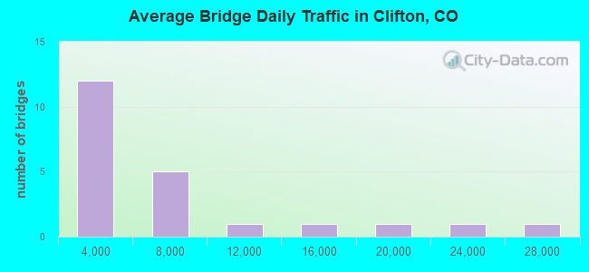
- National Bridge Inventory (NBI) Registered Bridges for Clifton
- No street view available for this location

- New bridges - historical statistics
- 11940-1949
- 101960-1969
- 11970-1979
- 31980-1989
- 21990-1999
- 42000-2009
- 12010-2019

- Reconstructed bridges - Historical Statistics
- 11970-1979
- 11980-1989
- 11990-1999
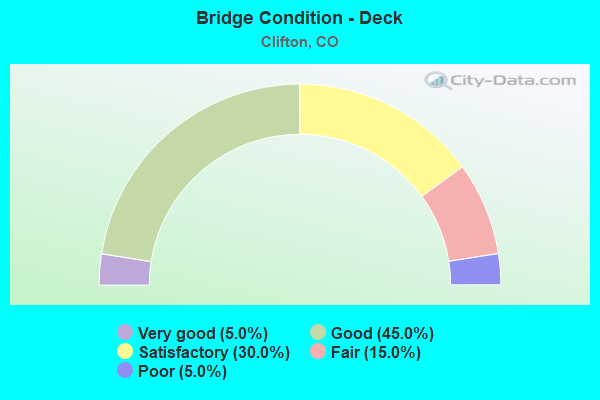
- Bridge Condition - Deck
- 5.0%Very good
- 45.0%Good
- 30.0%Satisfactory
- 15.0%Fair
- 5.0%Poor
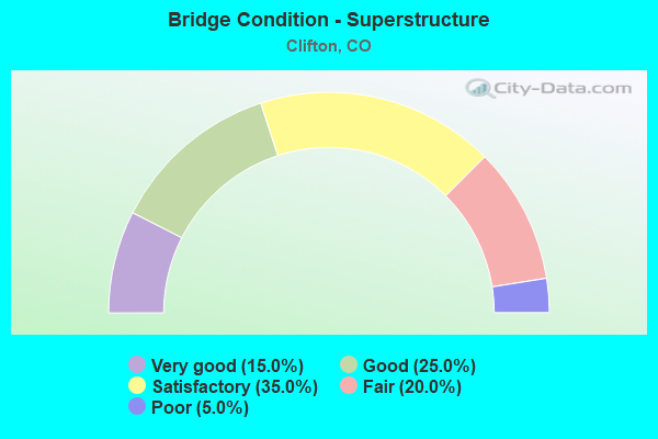
- Bridge Condition - Superstructure
- 15.0%Very good
- 25.0%Good
- 35.0%Satisfactory
- 20.0%Fair
- 5.0%Poor
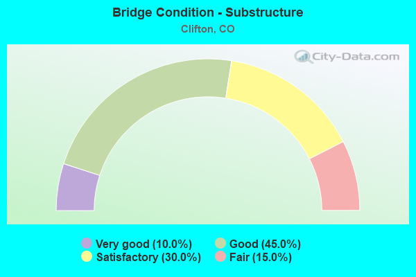
- Bridge Condition - Substructure
- 10.0%Very good
- 45.0%Good
- 30.0%Satisfactory
- 15.0%Fair
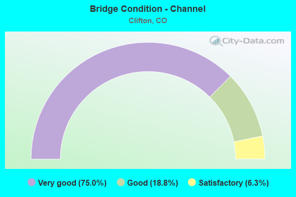
- Bridge Condition - Channel
- 75.0%Very good
- 18.8%Good
- 6.3%Satisfactory
Find on map >> Show street view
Structure Number: H-03-BD, Location: CLIFTON INTERCHANGE (Lat: 39.103711, Lng: -108.447517), Route carried "on" structure: Business State highway 70B, Year Built: 1964, Year Reconstructed: 1978, Status: Open, Structure Length: 7.14m (23.43ft), Average Daily Traffic: 15,000 (year 2020), Truck Traffic: 7%, Average Future Daily Traffic: 17,700 (year 2040), Design Load: HS 20, Features Intersected: I 70 ML, Facility Carried by Structure: I 70 BUS ROUTE
Minimum Vertical Clearance: 30+ m (98+ ft), Kilometerpoint: 20.942, Lanes on structure: 2, Lanes under structure: 5, Base Highway Network: Yes, Owner: State Highway Agency, Approaching Roadway Width: 15.2m (49.9ft), Skew: 32 degrees, Material/Design: Concrete continuous, Design/Construction: Tee Beam, Number Of Spans In Main Unit: 4, Length of Maximum Span: 22.6m (74.1ft), Curb-To-Curb Width: 15.2m (49.9ft), Out-to-Out Width: 16.8m (55.1ft)
Condition: Deck: Satisfactory, Superstructure: Satisfactory, Substructure: Satisfactory, Operating Rating: 43.6 metric tons, Method Used To Determine Operating Rating: Load Factor (LF), Inventory Rating: 26.1 metric tons, Method Used To Determine Inventory Rating: Load Factor (LF), Structural Evaluation: Equal to present minimum criteria, Deck Geometry: Superior to present desirable criteria, Underclear: High priority of corrective action, Approach Roadway Alignment: Equal to present desirable criteria, Designated Inspection Frequency: Every 24 months, Inspection Date: January 2021, Deck Structure Type: Concrete Cast-file-Place, Wearing Surface/Protective System: Wearing Surface: Bituminous, Membrane: Built-up
Find on map >> Show street view
Structure Number: H-03-BE, Location: 12 MI W OF JCT SH 65 ML (Lat: 39.106858, Lng: -108.440986), Route carried "on" structure: County highway , Year Built: 1963, Status: Open, Structure Length: 8.30m (27.23ft), Average Daily Traffic: 244 (year 2014), Truck Traffic: 2%, Average Future Daily Traffic: 368 (year 2034), Design Load: HS 20, Features Intersected: I 70 ML, Facility Carried by Structure: COUNTY ROAD 33
Minimum Vertical Clearance: 30+ m (98+ ft), Kilometerpoint: 4.134, Lanes on structure: 2, Lanes under structure: 5, Owner: State Highway Agency, Approaching Roadway Width: 8.5m (27.9ft), Skew: 2 degrees, Material/Design: Concrete continuous, Design/Construction: Tee Beam, Number Of Spans In Main Unit: 4, Length of Maximum Span: 23.5m (77.1ft), Curb or Sidewalk Widths: Left: 0.6m (2.0ft), Right: 0.6m (2.0ft), Curb-To-Curb Width: 7.3m (24.0ft), Out-to-Out Width: 8.5m (27.9ft)
Condition: Deck: Satisfactory, Superstructure: Satisfactory, Substructure: Satisfactory, Operating Rating: 40.4 metric tons, Method Used To Determine Operating Rating: Load Factor (LF), Inventory Rating: 24.1 metric tons, Method Used To Determine Inventory Rating: Load Factor (LF), Structural Evaluation: Equal to present minimum criteria, Deck Geometry: Somewhat better than minimum adequacy, Underclear: Meets minimum limits, Approach Roadway Alignment: Equal to present desirable criteria, Length Of Structure Improvement: 8.30m (27.23ft), Designated Inspection Frequency: Every 24 months, Inspection Date: March 2020, Bridge Improvement Cost: $354,000, Roadway Improvement Cost: $35,000, Total Project Cost: $531,000, Deck Structure Type: Concrete Cast-file-Place, Wearing Surface/Protective System: Wearing Surface: Monolithic Concrete
Find on map >> Show street view
Structure Number: H-03-BG, Location: JUST S OF I70 CLIFTON INT (Lat: 39.100092, Lng: -108.447761), Route carried "on" structure: Business State highway 70B, Year Built: 1963, Status: Open, Structure Length: 2.77m (9.09ft), Average Daily Traffic: 7,500 (year 2020), Truck Traffic: 7%, Average Future Daily Traffic: 8,850 (year 2040), Design Load: HS 20, Features Intersected: HIGHLINE CANAL, Facility Carried by Structure: I 70 BUSINESS EBND
Minimum Vertical Clearance: 30+ m (98+ ft), Kilometerpoint: 20.527, Lanes on structure: 2, Base Highway Network: Yes, Owner: State Highway Agency, Approaching Roadway Width: 11.6m (38.1ft), Skew: 13 degrees, Material/Design: Concrete, Design/Construction: Tee Beam, Number Of Spans In Main Unit: 3, Length of Maximum Span: 15.0m (49.2ft), Curb-To-Curb Width: 9.1m (29.9ft), Out-to-Out Width: 10.4m (34.1ft)
Condition: Deck: Satisfactory, Superstructure: Good, Substructure: Fair, Channel: Very good, Operating Rating: 46.3 metric tons, Method Used To Determine Operating Rating: Load Factor (LF), Inventory Rating: 27.2 metric tons, Method Used To Determine Inventory Rating: Load Factor (LF), Structural Evaluation: Somewhat better than minimum adequacy, Deck Geometry: Meets minimum limits, Waterway Adequacy: Superior to present desirable criteria, Approach Roadway Alignment: Equal to present desirable criteria, Designated Inspection Frequency: Every 24 months, Inspection Date: January 2021, Deck Structure Type: Concrete Cast-file-Place, Wearing Surface/Protective System: Wearing Surface: Bituminous, Membrane: Built-up
Find on map >> Show street view
Structure Number: H-03-BI, Location: JUST S. OF I70 CLIFTON IN (Lat: 39.100183, Lng: -108.447911), Route carried "on" structure: Business State highway 70B, Year Built: 1965, Status: Open, Structure Length: 2.76m (9.06ft), Average Daily Traffic: 7,500 (year 2020), Truck Traffic: 7%, Average Future Daily Traffic: 8,850 (year 2040), Design Load: HS 20, Features Intersected: HIGHLINE CANAL, Facility Carried by Structure: I 70 BUSINESS WBND
Minimum Vertical Clearance: 30+ m (98+ ft), Kilometerpoint: 20.532, Lanes on structure: 2, Base Highway Network: Yes, Owner: State Highway Agency, Approaching Roadway Width: 11.0m (36.1ft), Skew: 13 degrees, Material/Design: Concrete, Design/Construction: Tee Beam, Number Of Spans In Main Unit: 3, Length of Maximum Span: 15.2m (49.9ft), Curb-To-Curb Width: 9.1m (29.9ft), Out-to-Out Width: 10.4m (34.1ft)
Condition: Deck: Good, Superstructure: Good, Substructure: Fair, Channel: Very good, Operating Rating: 54.0 metric tons, Method Used To Determine Operating Rating: Load Factor (LF), Inventory Rating: 32.3 metric tons, Method Used To Determine Inventory Rating: Load Factor (LF), Structural Evaluation: Somewhat better than minimum adequacy, Deck Geometry: Meets minimum limits, Waterway Adequacy: Equal to present desirable criteria, Approach Roadway Alignment: Better than present minimum criteria, Designated Inspection Frequency: Every 24 months, Inspection Date: January 2021, Deck Structure Type: Concrete Cast-file-Place, Wearing Surface/Protective System: Wearing Surface: Bituminous
Find on map >> Show street view
Structure Number: H-03-BL, Location: S EDGE OF CLIFTON (Lat: 39.054647, Lng: -108.459494), Route carried "on" structure: US 141B, Year Built: 1968, Status: Open, Structure Length: 8.85m (29.04ft), Average Daily Traffic: 8,300 (year 2020), Truck Traffic: 7%, Average Future Daily Traffic: 8,466 (year 2040), Design Load: HS 20, Features Intersected: COLORADO RIVER, Facility Carried by Structure: SH 141 ML
Minimum Vertical Clearance: 30+ m (98+ ft), Kilometerpoint: 4.978, Lanes on structure: 2, Base Highway Network: Yes, Owner: State Highway Agency, Approaching Roadway Width: 13.4m (44.0ft), Skew: 2 degrees, Material/Design: Prestressed concrete, Design/Construction: Stringer/Multi-beam, Number Of Spans In Main Unit: 3, Length of Maximum Span: 29.1m (95.5ft), Curb-To-Curb Width: 9.8m (32.2ft), Out-to-Out Width: 10.7m (35.1ft)
Condition: Deck: Poor, Superstructure: Satisfactory, Substructure: Satisfactory, Channel: Satisfactory, Operating Rating: 51.7 metric tons, Method Used To Determine Operating Rating: Load Factor (LF), Inventory Rating: 27.5 metric tons, Method Used To Determine Inventory Rating: Load Factor (LF), Structural Evaluation: Equal to present minimum criteria, Deck Geometry: Meets minimum limits, Waterway Adequacy: Equal to present desirable criteria, Approach Roadway Alignment: Equal to present desirable criteria, Designated Inspection Frequency: Every 24 months, Underwater Inspection Frequency: Every 60 months, Inspection Date: October 2020, Underwater Inspection Date: August 2020, Bridge Improvement Cost: $3,353,000, Roadway Improvement Cost: $335,000, Total Project Cost: $5,030,000 ( Estimate for 2016), Deck Structure Type: Concrete Cast-file-Place, Wearing Surface/Protective System: Wearing Surface: Bituminous
Find on map >> Show street view
Structure Number: H-03-BN, Location: 5.2 M E OF JCT SH 50 (Lat: 39.086014, Lng: -108.457225), Route carried "on" structure: US 141B, Year Built: 1984, Status: Open, Structure Length: 7.82m (25.66ft), Average Daily Traffic: 17,000 (year 2020), Truck Traffic: 4%, Average Future Daily Traffic: 17,680 (year 2040), Design Load: HS 20+Mod, Features Intersected: UP RR, Facility Carried by Structure: SH 141 ML
Minimum Vertical Clearance: 30+ m (98+ ft), Kilometerpoint: 8.521, Lanes on structure: 4, Base Highway Network: Yes, Owner: State Highway Agency, Approaching Roadway Width: 24.4m (80.1ft), Skew: 5 degrees, Material/Design: Steel continuous, Design/Construction: Stringer/Multi-beam, Number Of Spans In Main Unit: 3, Length of Maximum Span: 30.5m (100.1ft), Curb or Sidewalk Widths: Left: 1.3m (4.3ft), Right: 1.3m (4.3ft), Curb-To-Curb Width: 24.4m (80.1ft), Out-to-Out Width: 28.0m (91.9ft)
Condition: Deck: Good, Superstructure: Fair, Substructure: Good, Operating Rating: 55.1 metric tons, Method Used To Determine Operating Rating: Load Factor (LF), Inventory Rating: 33.1 metric tons, Method Used To Determine Inventory Rating: Load Factor (LF), Structural Evaluation: Somewhat better than minimum adequacy, Deck Geometry: Superior to present desirable criteria, Underclear: Superior to present desirable criteria, Approach Roadway Alignment: Equal to present desirable criteria, Designated Inspection Frequency: Every 24 months, Inspection Date: January 2021, Deck Structure Type: Concrete Cast-file-Place, Wearing Surface/Protective System: Wearing Surface: Bituminous, Membrane: Preformed Fabric
Find on map >> Show street view
Structure Number: H-03-BW, Location: E. EDGE OF CLIFTON (Lat: 39.091386, Lng: -108.436053), Route carried "on" structure: US 6C, Year Built: 1999, Status: Open, Structure Length: 7.34m (24.08ft), Average Daily Traffic: 6,900 (year 2020), Truck Traffic: 4%, Average Future Daily Traffic: 7,383 (year 2040), Design Load: HS 20, Features Intersected: UP RR, Facility Carried by Structure: US 6 ML
Minimum Vertical Clearance: 30+ m (98+ ft), Kilometerpoint: 1.585, Lanes on structure: 2, Owner: State Highway Agency, Approaching Roadway Width: 12.2m (40.0ft), Skew: 4 degrees, Material/Design: Prestressed concrete continuous, Design/Construction: Box Beam or Girders - Multiple, Number Of Spans In Main Unit: 3, Length of Maximum Span: 36.4m (119.4ft), Curb-To-Curb Width: 12.0m (39.4ft), Out-to-Out Width: 12.9m (42.3ft)
Condition: Deck: Good, Superstructure: Very good, Substructure: Good, Operating Rating: 81.6 metric tons, Method Used To Determine Operating Rating: Load Factor (LF), Inventory Rating: 48.8 metric tons, Method Used To Determine Inventory Rating: Load Factor (LF), Structural Evaluation: Better than present minimum criteria, Deck Geometry: Somewhat better than minimum adequacy, Underclear: Superior to present desirable criteria, Approach Roadway Alignment: Equal to present desirable criteria, Designated Inspection Frequency: Every 24 months, Inspection Date: January 2021, Deck Structure Type: Concrete Cast-file-Place, Wearing Surface/Protective System: Wearing Surface: Bituminous, Membrane: Preformed Fabric, Deck Protection: Epoxy Coated Reinforcing
Find on map >> Show street view
Structure Number: MESA-31-C.83A, Location: .17 MI S OF ROAD D (Lat: 39.060667, Lng: -108.478000), Route carried "on" structure: County highway , Year Built: 2009, Status: Open, Structure Length: 0.76m (2.49ft), Average Daily Traffic: 56 (year 2018), Average Future Daily Traffic: 84 (year 2038), Design Load: HS 20, Features Intersected: LEWIS WASH, Facility Carried by Structure: COUNTY ROAD 31
Minimum Vertical Clearance: 30+ m (98+ ft), Kilometerpoint: 0.140, Lanes on structure: 2, Owner: County Highway Agency, Approaching Roadway Width: 5.5m (18.0ft), Skew: 2 degrees, Material/Design: Prestressed concrete, Design/Construction: Slab, Number Of Spans In Main Unit: 1, Length of Maximum Span: 7.0m (23.0ft), Curb-To-Curb Width: 7.2m (23.6ft), Out-to-Out Width: 8.2m (26.9ft)
Condition: Deck: Very good, Superstructure: Very good, Substructure: Very good, Channel: Very good, Operating Rating: 60.0 metric tons, Method Used To Determine Operating Rating: Load Factor (LF), Inventory Rating: 35.9 metric tons, Method Used To Determine Inventory Rating: Load Factor (LF), Structural Evaluation: Equal to present desirable criteria, Deck Geometry: Somewhat better than minimum adequacy, Waterway Adequacy: Equal to present desirable criteria, Approach Roadway Alignment: Equal to present desirable criteria, Designated Inspection Frequency: Every 24 months, Inspection Date: Febuary 2022, Deck Structure Type: Other, Wearing Surface/Protective System: Wearing Surface: Gravel
Find on map >> Show street view
Structure Number: MESA-31-E.2, Location: .2 MI N OF RD E (Lat: 39.079417, Lng: -108.477972), Route carried "on" structure: County highway , Year Built: 1949, Year Reconstructed: 1990, Status: Open, Structure Length: 1.04m (3.41ft), Average Daily Traffic: 72 (year 2018), Average Future Daily Traffic: 109 (year 2038), Features Intersected: GRAND VALLEY CANAL, Facility Carried by Structure: COUNTY ROAD 31
Minimum Vertical Clearance: 30+ m (98+ ft), Kilometerpoint: 0.003, Lanes on structure: 2, Owner: County Highway Agency, Approaching Roadway Width: 6.1m (20.0ft), Material/Design: Steel, Design/Construction: Stringer/Multi-beam, Number Of Spans In Main Unit: 1, Length of Maximum Span: 9.5m (31.2ft), Curb-To-Curb Width: 5.1m (16.7ft), Out-to-Out Width: 5.6m (18.4ft)
Condition: Deck: Satisfactory, Superstructure: Fair, Substructure: Good, Channel: Very good, Operating Rating: 41.1 metric tons, Method Used To Determine Operating Rating: Load Factor (LF), Inventory Rating: 24.6 metric tons, Method Used To Determine Inventory Rating: Load Factor (LF), Structural Evaluation: Somewhat better than minimum adequacy, Deck Geometry: High priority of corrective action, Waterway Adequacy: Equal to present desirable criteria, Approach Roadway Alignment: Equal to present desirable criteria, Length Of Structure Improvement: 1.04m (3.41ft), Designated Inspection Frequency: Every 24 months, Inspection Date: Febuary 2022, Bridge Improvement Cost: $104,000, Roadway Improvement Cost: $10,000, Total Project Cost: $115,000 ( Estimate for 2020), Deck Structure Type: Corrugated Steel, Wearing Surface/Protective System: Wearing Surface: Gravel
Find on map >> Show street view
Structure Number: MESA-31.5-E.2A, Location: .2 MI N OF RD E (Lat: 39.078861, Lng: -108.468722), Route carried "on" structure: County highway , Year Built: 2001, Status: Open, Structure Length: 1.31m (4.30ft), Average Daily Traffic: 4,277 (year 2018), Truck Traffic: 5%, Average Future Daily Traffic: 6,459 (year 2038), Design Load: HS 20, Features Intersected: GRAND VALLEY CANAL, Facility Carried by Structure: COUNTY ROAD 31.5
Minimum Vertical Clearance: 30+ m (98+ ft), Kilometerpoint: 0.179, Lanes on structure: 2, Owner: County Highway Agency, Approaching Roadway Width: 6.7m (22.0ft), Skew: 1 degrees, Material/Design: Steel, Design/Construction: Stringer/Multi-beam, Number Of Spans In Main Unit: 1, Length of Maximum Span: 11.9m (39.0ft), Curb or Sidewalk Widths: Left: 1.5m (4.9ft), Right: 1.5m (4.9ft), Curb-To-Curb Width: 14.5m (47.6ft), Out-to-Out Width: 18.3m (60.0ft)
Condition: Deck: Good, Superstructure: Satisfactory, Substructure: Good, Channel: Very good, Operating Rating: 51.3 metric tons, Method Used To Determine Operating Rating: Load Factor (LF), Inventory Rating: 30.7 metric tons, Method Used To Determine Inventory Rating: Load Factor (LF), Structural Evaluation: Equal to present minimum criteria, Deck Geometry: Superior to present desirable criteria, Waterway Adequacy: Equal to present desirable criteria, Approach Roadway Alignment: Equal to present desirable criteria, Designated Inspection Frequency: Every 24 months, Inspection Date: Febuary 2022, Deck Structure Type: Concrete Cast-file-Place, Wearing Surface/Protective System: Wearing Surface: Bituminous
Find on map >> Show street view
Structure Number: MESA-32.5-E.1, Location: .1 MI N OF RD E (Lat: 39.078667, Lng: -108.450194), Route carried "on" structure: County highway , Year Built: 1966, Status: Open, Structure Length: 1.00m (3.28ft), Average Daily Traffic: 2,510 (year 2018), Truck Traffic: 5%, Average Future Daily Traffic: 3,789 (year 2038), Features Intersected: GRAND VALLEY CANAL, Facility Carried by Structure: COUNTY ROAD 32.5
Minimum Vertical Clearance: 30+ m (98+ ft), Kilometerpoint: 0.151, Lanes on structure: 2, Owner: County Highway Agency, Approaching Roadway Width: 8.5m (27.9ft), Skew: 1 degrees, Material/Design: Steel, Design/Construction: Stringer/Multi-beam, Number Of Spans In Main Unit: 1, Length of Maximum Span: 9.2m (30.2ft), Curb or Sidewalk Widths: Left: 0.4m (1.3ft), Right: 0.4m (1.3ft), Curb-To-Curb Width: 8.0m (26.2ft), Out-to-Out Width: 8.7m (28.5ft)
Condition: Deck: Good, Superstructure: Fair, Substructure: Good, Channel: Very good, Operating Rating: 42.4 metric tons, Method Used To Determine Operating Rating: Load Factor (LF), Inventory Rating: 25.4 metric tons, Method Used To Determine Inventory Rating: Load Factor (LF), Structural Evaluation: Somewhat better than minimum adequacy, Deck Geometry: High priority of corrective action, Waterway Adequacy: Equal to present desirable criteria, Approach Roadway Alignment: Equal to present desirable criteria, Length Of Structure Improvement: 1.00m (3.28ft), Designated Inspection Frequency: Every 24 months, Inspection Date: Febuary 2022, Bridge Improvement Cost: $168,000, Roadway Improvement Cost: $17,000, Total Project Cost: $184,000 ( Estimate for 2020), Deck Structure Type: Concrete Cast-file-Place, Wearing Surface/Protective System: Wearing Surface: Bituminous
Find on map >> Show street view
Structure Number: MESA-33-E.2A, Location: .2 MILES N OF ROAD E (Lat: 39.080806, Lng: -108.440833), Route carried "on" structure: County highway , Year Built: 2009, Status: Open, Structure Length: 1.43m (4.69ft), Average Daily Traffic: 3,535 (year 2018), Truck Traffic: 5%, Average Future Daily Traffic: 5,338 (year 2038), Design Load: HS 25 or greater, Features Intersected: GRAND VALLEY CANAL, Facility Carried by Structure: COUNTY ROAD 33
Minimum Vertical Clearance: 30+ m (98+ ft), Kilometerpoint: 1.194, Lanes on structure: 3, Owner: County Highway Agency, Approaching Roadway Width: 14.6m (47.9ft), Skew: 4 degrees, Material/Design: Prestressed concrete, Design/Construction: Box Beam or Girders - Multiple, Number Of Spans In Main Unit: 1, Length of Maximum Span: 13.3m (43.6ft), Curb or Sidewalk Widths: Left: 1.5m (4.9ft), Right: 4.6m (15.1ft), Curb-To-Curb Width: 14.6m (47.9ft), Out-to-Out Width: 20.7m (67.9ft)
Condition: Deck: Good, Superstructure: Good, Substructure: Good, Channel: Very good, Operating Rating: 98.3 metric tons, Method Used To Determine Operating Rating: Load Factor (LF), Inventory Rating: 57.8 metric tons, Method Used To Determine Inventory Rating: Load Factor (LF), Structural Evaluation: Better than present minimum criteria, Deck Geometry: Somewhat better than minimum adequacy, Waterway Adequacy: Equal to present desirable criteria, Approach Roadway Alignment: Equal to present desirable criteria, Designated Inspection Frequency: Every 24 months, Inspection Date: Febuary 2022, Deck Structure Type: Concrete Cast-file-Place, Wearing Surface/Protective System: Wearing Surface: Bituminous, Membrane: Built-up, Deck Protection: Epoxy Coated Reinforcing
Find on map >> Show street view
Structure Number: MESA-33-F.63A, Location: NORTH OF CR 33 AND F 5/8 (Lat: 39.100833, Lng: -108.440944), Route carried "on" structure: County highway , Year Built: 2008, Status: Open, Structure Length: 1.48m (4.86ft), Average Daily Traffic: 1,690 (year 2018), Truck Traffic: 5%, Average Future Daily Traffic: 2,552 (year 2038), Design Load: HS 20, Features Intersected: GOVERNMENT HIGHLINE CANL, Facility Carried by Structure: COUNTY ROAD 33
Minimum Vertical Clearance: 30+ m (98+ ft), Kilometerpoint: 3.462, Lanes on structure: 2, Owner: County Highway Agency, Approaching Roadway Width: 7.0m (23.0ft), Skew: 1 degrees, Material/Design: Prestressed concrete, Design/Construction: Slab, Number Of Spans In Main Unit: 1, Length of Maximum Span: 13.6m (44.6ft), Curb or Sidewalk Widths: Left: 1.6m (5.2ft), Right: 1.6m (5.2ft), Curb-To-Curb Width: 14.2m (46.6ft), Out-to-Out Width: 18.3m (60.0ft)
Condition: Deck: Good, Superstructure: Good, Substructure: Very good, Channel: Very good, Operating Rating: 57.6 metric tons, Method Used To Determine Operating Rating: Load Factor (LF), Inventory Rating: 34.1 metric tons, Method Used To Determine Inventory Rating: Load Factor (LF), Structural Evaluation: Better than present minimum criteria, Deck Geometry: Superior to present desirable criteria, Waterway Adequacy: Equal to present desirable criteria, Approach Roadway Alignment: Equal to present desirable criteria, Designated Inspection Frequency: Every 24 months, Inspection Date: Febuary 2022, Deck Structure Type: Other, Wearing Surface/Protective System: Wearing Surface: Bituminous
Find on map >> Show street view
Structure Number: MESA-33.75-E.5, Location: 0.25 MI N OF RD E.25 (Lat: 39.084972, Lng: -108.427111), Route carried "on" structure: County highway , Year Built: 1967, Status: Open, Structure Length: 1.22m (4.00ft), Average Daily Traffic: 880 (year 2018), Truck Traffic: 2%, Average Future Daily Traffic: 1,329 (year 2038), Features Intersected: GRAND VALLEY CANAL, Facility Carried by Structure: COUNTY ROAD 33.75
Minimum Vertical Clearance: 30+ m (98+ ft), Kilometerpoint: 0.469, Lanes on structure: 2, Owner: County Highway Agency, Approaching Roadway Width: 7.6m (24.9ft), Skew: 3 degrees, Material/Design: Steel, Design/Construction: Stringer/Multi-beam, Number Of Spans In Main Unit: 1, Length of Maximum Span: 11.2m (36.7ft), Curb or Sidewalk Widths: Left: 0.2m (0.7ft), Right: 0.2m (0.7ft), Curb-To-Curb Width: 8.2m (26.9ft), Out-to-Out Width: 8.6m (28.2ft)
Condition: Deck: Satisfactory, Superstructure: Satisfactory, Substructure: Good, Channel: Very good, Operating Rating: 34.9 metric tons, Method Used To Determine Operating Rating: Load Factor (LF), Inventory Rating: 26.5 metric tons, Method Used To Determine Inventory Rating: Load Factor (LF), Structural Evaluation: Equal to present minimum criteria, Deck Geometry: Somewhat better than minimum adequacy, Waterway Adequacy: Better than present minimum criteria, Approach Roadway Alignment: Equal to present minimum criteria, Designated Inspection Frequency: Every 24 months, Inspection Date: Febuary 2022, Deck Structure Type: Concrete Cast-file-Place, Wearing Surface/Protective System: Wearing Surface: Bituminous
Find on map >> Show street view
Structure Number: MESA-33.75-F.8A, Location: .8 MI N OF RD F (Lat: 39.103889, Lng: -108.427056), Route carried "on" structure: County highway , Year Built: 1986, Status: Open, Structure Length: 1.23m (4.04ft), Average Daily Traffic: 168 (year 2018), Truck Traffic: 2%, Average Future Daily Traffic: 253 (year 2038), Features Intersected: GOVT. HIGHLINE CANAL, Facility Carried by Structure: COUNTY ROAD 33.75
Minimum Vertical Clearance: 30+ m (98+ ft), Kilometerpoint: 1.385, Lanes on structure: 2, Owner: County Highway Agency, Approaching Roadway Width: 7.0m (23.0ft), Material/Design: Steel, Design/Construction: Stringer/Multi-beam, Number Of Spans In Main Unit: 1, Length of Maximum Span: 11.7m (38.4ft), Curb-To-Curb Width: 9.3m (30.5ft), Out-to-Out Width: 9.8m (32.2ft)
Condition: Deck: Fair, Superstructure: Satisfactory, Substructure: Satisfactory, Channel: Very good, Operating Rating: 34.3 metric tons, Method Used To Determine Operating Rating: Load Factor (LF), Inventory Rating: 20.5 metric tons, Method Used To Determine Inventory Rating: Load Factor (LF), Structural Evaluation: Somewhat better than minimum adequacy, Deck Geometry: Equal to present minimum criteria, Waterway Adequacy: Equal to present desirable criteria, Approach Roadway Alignment: Equal to present minimum criteria, Designated Inspection Frequency: Every 24 months, Inspection Date: Febuary 2022, Deck Structure Type: Corrugated Steel, Wearing Surface/Protective System: Wearing Surface: Bituminous
Find on map >> Show street view
Structure Number: MESA-34-E.4, Location: .4 MI S OF F RD (Lat: 39.084472, Lng: -108.422417), Route carried "on" structure: County highway , Year Built: 1970, Status: Open, Structure Length: 1.18m (3.87ft), Average Daily Traffic: 495 (year 2018), Truck Traffic: 2%, Average Future Daily Traffic: 748 (year 2038), Design Load: HS 20, Features Intersected: GRAND VALLEY CANAL, Facility Carried by Structure: COUNTY ROAD 34
Minimum Vertical Clearance: 30+ m (98+ ft), Kilometerpoint: 0.438, Lanes on structure: 2, Owner: County Highway Agency, Approaching Roadway Width: 7.6m (24.9ft), Skew: 3 degrees, Material/Design: Prestressed concrete, Design/Construction: Tee Beam, Number Of Spans In Main Unit: 1, Length of Maximum Span: 11.0m (36.1ft), Curb-To-Curb Width: 6.3m (20.7ft), Out-to-Out Width: 7.0m (23.0ft)
Condition: Deck: Satisfactory, Superstructure: Satisfactory, Substructure: Satisfactory, Channel: Good, Operating Rating: 36.3 metric tons, Method Used To Determine Operating Rating: Field evaluation and documented engineering judgment, Inventory Rating: 32.7 metric tons, Method Used To Determine Inventory Rating: Field evaluation and documented engineering judgment, Structural Evaluation: Equal to present minimum criteria, Deck Geometry: High priority of corrective action, Waterway Adequacy: Equal to present desirable criteria, Approach Roadway Alignment: Equal to present desirable criteria, Length Of Structure Improvement: 1.18m (3.87ft), Designated Inspection Frequency: Every 24 months, Inspection Date: Febuary 2020, Bridge Improvement Cost: $101,000, Roadway Improvement Cost: $10,000, Total Project Cost: $111,000 ( Estimate for 2020), Deck Structure Type: Concrete Cast-file-Place, Wearing Surface/Protective System: Wearing Surface: Bituminous
Find on map >> Show street view
Structure Number: MESA-34-F.9A, Location: .9 MI N OF RD F (Lat: 39.104833, Lng: -108.422417), Route carried "on" structure: County highway , Year Built: 1960, Year Reconstructed: 1985, Status: Open, Structure Length: 1.36m (4.46ft), Average Daily Traffic: 124 (year 2018), Truck Traffic: 2%, Average Future Daily Traffic: 188 (year 2038), Features Intersected: GOVT. HIGHLINE CANAL, Facility Carried by Structure: COUNTY ROAD 34
Minimum Vertical Clearance: 30+ m (98+ ft), Kilometerpoint: 2.718, Lanes on structure: 2, Owner: County Highway Agency, Approaching Roadway Width: 6.7m (22.0ft), Skew: 2 degrees, Material/Design: Steel, Design/Construction: Stringer/Multi-beam, Number Of Spans In Main Unit: 1, Length of Maximum Span: 12.9m (42.3ft), Curb-To-Curb Width: 7.5m (24.6ft), Out-to-Out Width: 8.0m (26.2ft)
Condition: Deck: Fair, Superstructure: Poor, Substructure: Fair, Channel: Good, Operating Rating: 22.2 metric tons, Method Used To Determine Operating Rating: Load Factor (LF), Inventory Rating: 13.3 metric tons, Method Used To Determine Inventory Rating: Load Factor (LF), Structural Evaluation: Meets minimum limits, Deck Geometry: Somewhat better than minimum adequacy, Waterway Adequacy: Better than present minimum criteria, Approach Roadway Alignment: Better than present minimum criteria, Length Of Structure Improvement: 2.05m (6.73ft), Designated Inspection Frequency: Every 24 months, Inspection Date: Febuary 2020, Bridge Improvement Cost: $989,000, Roadway Improvement Cost: $99,000, Total Project Cost: $1,088,000 ( Estimate for 2020), Deck Structure Type: Corrugated Steel, Wearing Surface/Protective System: Wearing Surface: Bituminous
Find on map >> Show street view
Structure Number: MESA-34.6-G.18, Location: 0.18 MI N OF COUNTY RD G (Lat: 39.108750, Lng: -108.411417), Route carried "on" structure: County highway , Year Built: 1992, Status: Open, Structure Length: 1.78m (5.84ft), Average Daily Traffic: 65 (year 2018), Average Future Daily Traffic: 98 (year 2038), Design Load: HS 20, Features Intersected: GOVT. HIGHLINE CANAL, Facility Carried by Structure: COUNTY ROAD 34.6
Minimum Vertical Clearance: 30+ m (98+ ft), Kilometerpoint: 0.259, Lanes on structure: 2, Owner: County Highway Agency, Approaching Roadway Width: 6.4m (21.0ft), Material/Design: Prestressed concrete, Design/Construction: Box Beam or Girders - Multiple, Number Of Spans In Main Unit: 1, Length of Maximum Span: 16.6m (54.5ft), Curb-To-Curb Width: 8.6m (28.2ft), Out-to-Out Width: 9.1m (29.9ft)
Condition: Deck: Good, Superstructure: Good, Substructure: Good, Channel: Very good, Operating Rating: 36.3 metric tons, Method Used To Determine Operating Rating: Field evaluation and documented engineering judgment, Inventory Rating: 32.7 metric tons, Method Used To Determine Inventory Rating: Field evaluation and documented engineering judgment, Structural Evaluation: Better than present minimum criteria, Deck Geometry: Better than present minimum criteria, Waterway Adequacy: Equal to present desirable criteria, Approach Roadway Alignment: Better than present minimum criteria, Designated Inspection Frequency: Every 24 months, Inspection Date: Febuary 2022, Deck Structure Type: Other, Wearing Surface/Protective System: Wearing Surface: Bituminous
Find on map >> Show street view
Structure Number: MESA-D.5-31.01, Location: JUST EAST OF CR 31 (Lat: 39.070111, Lng: -108.477778), Route carried "on" structure: County highway , Year Built: 2013, Status: Open, Structure Length: 1.00m (3.28ft), Average Daily Traffic: 6,816 (year 2018), Truck Traffic: 9%, Average Future Daily Traffic: 10,292 (year 2038), Design Load: HL 93, Features Intersected: LEWIS WASH, Facility Carried by Structure: COUNTY RD D.5
Minimum Vertical Clearance: 30+ m (98+ ft), Kilometerpoint: 0.209, Lanes on structure: 3, Owner: County Highway Agency, Approaching Roadway Width: 12.5m (41.0ft), Material/Design: Prestressed concrete, Design/Construction: Slab, Number Of Spans In Main Unit: 1, Length of Maximum Span: 8.6m (28.2ft), Curb or Sidewalk Widths: Left: 2.1m (6.9ft), Right: 2.1m (6.9ft), Curb-To-Curb Width: 12.8m (42.0ft), Out-to-Out Width: 24.1m (79.1ft)
Condition: Deck: Good, Superstructure: Very good, Substructure: Good, Channel: Good, Operating Rating: 51.2 metric tons, Method Used To Determine Operating Rating: Load and Resistance Factor Rating (LRFR) rating reported by rating factor(RF) method using HL-93 loadings, Inventory Rating: 39.5 metric tons, Method Used To Determine Inventory Rating: Load and Resistance Factor Rating (LRFR) rating reported by rating factor(RF) method using HL-93 loadings, Structural Evaluation: Better than present minimum criteria, Deck Geometry: Meets minimum limits, Waterway Adequacy: Equal to present desirable criteria, Approach Roadway Alignment: Equal to present desirable criteria, Designated Inspection Frequency: Every 24 months, Inspection Date: January 2022, Deck Structure Type: Concrete Cast-file-Place, Wearing Surface/Protective System: Wearing Surface: Bituminous, Membrane: Built-up
Find on map >> Show street view
Structure Number: MESA-G-34.1A, Location: .1 MI E OF RD 34 (Lat: 39.106278, Lng: -108.419667), Route carried "on" structure: County highway , Year Built: 1985, Status: Open, Structure Length: 2.03m (6.66ft), Average Daily Traffic: 1,274 (year 2018), Truck Traffic: 5%, Average Future Daily Traffic: 1,924 (year 2038), Features Intersected: GOVT. HIGHLINE CANAL, Facility Carried by Structure: COUNTY ROAD G
Minimum Vertical Clearance: 30+ m (98+ ft), Kilometerpoint: 1.914, Lanes on structure: 2, Owner: County Highway Agency, Approaching Roadway Width: 7.6m (24.9ft), Skew: 5 degrees, Material/Design: Steel, Design/Construction: Stringer/Multi-beam, Number Of Spans In Main Unit: 1, Length of Maximum Span: 19.3m (63.3ft), Curb-To-Curb Width: 9.2m (30.2ft), Out-to-Out Width: 9.7m (31.8ft)
Condition: Deck: Fair, Superstructure: Fair, Substructure: Satisfactory, Channel: Very good, Operating Rating: 36.8 metric tons, Method Used To Determine Operating Rating: Load Factor (LF), Inventory Rating: 22.0 metric tons, Method Used To Determine Inventory Rating: Load Factor (LF), Structural Evaluation: Somewhat better than minimum adequacy, Deck Geometry: Somewhat better than minimum adequacy, Waterway Adequacy: Equal to present desirable criteria, Approach Roadway Alignment: Equal to present desirable criteria, Designated Inspection Frequency: Every 24 months, Inspection Date: Febuary 2022, Deck Structure Type: Corrugated Steel, Wearing Surface/Protective System: Wearing Surface: Bituminous
Find on map >> Show street view
Structure Number: H-03-BD, Location: CLIFTON INTERCHANGE (Lat: 39.103711, Lng: -108.447517), Route carried "under" structure: Interstate 70A, Year Built: 1964, Structure Length: 0. m, Average Daily Traffic: 21,000 (year 2011), Truck Traffic: 13%, Features Intersected: I 70 ML, Facility Carried by Structure: I 70 BUS ROUTE
Minimum Vertical Clearance: 5.66m (18.57ft), Kilometerpoint: 58.960, Lanes on structure: 2, Lanes under structure: 5, Material/Design: Concrete continuous, Design/Construction: Tee Beam, Length of Maximum Span: 22.6m (74.1ft)
Find on map >> Show street view
Structure Number: H-03-BE, Location: 12 MI W OF JCT SH 65 ML (Lat: 39.106858, Lng: -108.440986), Route carried "under" structure: Interstate 70A, Year Built: 1963, Structure Length: 0. m, Average Daily Traffic: 26,000 (year 2018), Truck Traffic: 14%, Features Intersected: I 70 ML, Facility Carried by Structure: COUNTY ROAD 33
Minimum Vertical Clearance: 5.72m (18.77ft), Kilometerpoint: 4.105, Lanes on structure: 2, Lanes under structure: 5, Material/Design: Concrete continuous, Design/Construction: Tee Beam, Length of Maximum Span: 23.5m (77.1ft)