Bridge Statistics for Clifford, Michigan (MI)
Condition, Traffic, Stress, Structural Evaluation, Project Costs
- National Bridge Inventory (NBI) Statistics
- 14Number of bridges
- 95ft / 29.1mTotal length
- $229,000Total costs
- 57,169Total average daily traffic
- 8,619Total average daily truck traffic
- 78,396Total future (year 2018) average daily traffic
- National Bridge Inventory (NBI) Registered Bridges for Clifford
- No street view available for this location
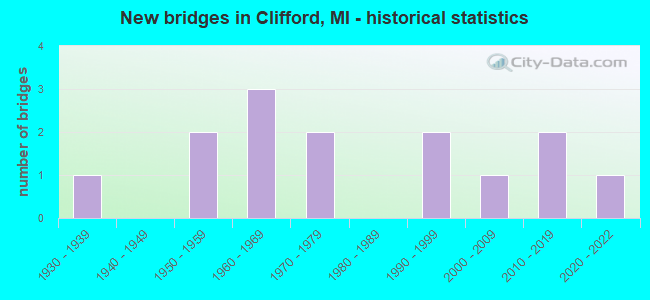
- New bridges - historical statistics
- 11930-1939
- 21950-1959
- 31960-1969
- 21970-1979
- 21990-1999
- 12000-2009
- 22010-2019
- 12020-2022

- Reconstructed bridges - Historical Statistics
- 21970-1979
- 01980-1989
- 01990-1999
- 12000-2009


- Bridge Condition - Deck
- 11.1%Very good
- 22.2%Good
- 33.3%Satisfactory
- 33.3%Fair

- Bridge Condition - Superstructure
- 22.2%Very good
- 22.2%Good
- 44.4%Satisfactory
- 11.1%Fair

- Bridge Condition - Substructure
- 11.1%Very good
- 44.4%Good
- 22.2%Satisfactory
- 22.2%Fair

- Bridge Condition - Channel
- 16.7%Very good
- 8.3%Good
- 50.0%Satisfactory
- 16.7%Fair
- 8.3%Poor

- Bridge Condition - Culverts
- 60.0%Good
- 40.0%Satisfactory
Find on map >> Show street view
Structure Number: 794, Location: 1.0 MI N OF STEVENSVILLE (Lat: 42.032889, Lng: -86.510867), Route carried "on" structure: Interstate 94, Year Built: 1960, Year Reconstructed: 1978, Status: Open, Structure Length: 5.97m (19.59ft), Average Daily Traffic: 22,145 (year 2007), Truck Traffic: 28%, Average Future Daily Traffic: 31,354 (year 2018), Design Load: HS 20, Features Intersected: CSX RR
Minimum Vertical Clearance: 30.48m (100.00ft), Kilometerpoint: 37.961, Lanes on structure: 4, Base Highway Network: Yes (Inventory Route: 136, Subroute: 4), Owner: State Highway Agency, Approaching Roadway Width: 17.9m (58.7ft), Skew: 4 degrees, Material/Design: Steel, Design/Construction: Stringer/Multi-beam, Number Of Spans In Main Unit: 3, Length of Maximum Span: 19.8m (65.0ft), Curb-To-Curb Width: 20.6m (67.6ft), Out-to-Out Width: 21.4m (70.2ft)
Condition: Deck: Fair, Superstructure: Fair, Substructure: Satisfactory, Operating Rating: 64.9 metric tons, Method Used To Determine Operating Rating: Load Factor (LF), Inventory Rating: 38.9 metric tons, Method Used To Determine Inventory Rating: Load Factor (LF), Structural Evaluation: Somewhat better than minimum adequacy, Deck Geometry: Equal to present minimum criteria, Underclear: Better than present minimum criteria, Approach Roadway Alignment: Equal to present desirable criteria, Designated Inspection Frequency: Every 24 months, Inspection Date: August 2020, Bridge Improvement Cost: $427,000, Deck Structure Type: Concrete Cast-file-Place, Wearing Surface/Protective System: Wearing Surface: Latex Concrete
Find on map >> Show street view
Structure Number: 5385, Location: SEC. 16-17 BURLINGTON TWP (Lat: 43.290264, Lng: -83.198572), Route carried "on" structure: County highway 4457, Year Built: 2017, Status: Open, Structure Length: 0.61m (2.00ft), Average Daily Traffic: 1,034 (year 2020), Average Future Daily Traffic: 1,262 (year 2040), Design Load: H 20, Features Intersected: INDIAN CREEK DRAIN, Facility Carried by Structure: JEFFERSON ROAD
Minimum Vertical Clearance: 30.48m (100.00ft), Kilometerpoint: 16.577, Lanes on structure: 2, Owner: County Highway Agency, Approaching Roadway Width: 9.1m (29.9ft), Material/Design: Concrete, Design/Construction: Culvert, Number Of Spans In Main Unit: 1, Length of Maximum Span: 6.1m (20.0ft), Out-to-Out Width: 14.7m (48.2ft)
Condition: Channel: Very good, Culverts: Good, Operating Rating: 97.2 metric tons, Method Used To Determine Operating Rating: Load and Resistance Factor Rating (LRFR) rating reported by rating factor(RF) method using HL-93 loadings, Inventory Rating: 75.8 metric tons, Method Used To Determine Inventory Rating: Load and Resistance Factor Rating (LRFR) rating reported by rating factor(RF) method using HL-93 loadings, Structural Evaluation: Better than present minimum criteria, Waterway Adequacy: Better than present minimum criteria, Approach Roadway Alignment: Equal to present desirable criteria, Designated Inspection Frequency: Every 24 months, Inspection Date: September 2021
Find on map >> Show street view
Structure Number: 5401, Location: SEC. 18-19 BURLINGTON TWP (Lat: 43.281444, Lng: -83.220297), Route carried "on" structure: ServiceCounty highway , Year Built: 2017, Status: Open, Structure Length: 0.67m (2.20ft), Average Daily Traffic: 54 (year 2020), Average Future Daily Traffic: 66 (year 2040), Design Load: H 20, Features Intersected: INDIAN CREEK DRAIN, Facility Carried by Structure: MILLINGTON ROAD
Minimum Vertical Clearance: 30.48m (100.00ft), Kilometerpoint: 6.565, Lanes on structure: 2, Owner: County Highway Agency, Approaching Roadway Width: 6.1m (20.0ft), Material/Design: Concrete, Design/Construction: Culvert, Number Of Spans In Main Unit: 1, Length of Maximum Span: 6.7m (22.0ft), Out-to-Out Width: 16.5m (54.1ft)
Condition: Channel: Very good, Culverts: Good, Operating Rating: 60.9 metric tons, Method Used To Determine Operating Rating: Load and Resistance Factor Rating (LRFR) rating reported by rating factor(RF) method using HL-93 loadings, Inventory Rating: 47.0 metric tons, Method Used To Determine Inventory Rating: Load and Resistance Factor Rating (LRFR) rating reported by rating factor(RF) method using HL-93 loadings, Structural Evaluation: Better than present minimum criteria, Waterway Adequacy: Better than present minimum criteria, Approach Roadway Alignment: Better than present minimum criteria, Designated Inspection Frequency: Every 24 months, Inspection Date: September 2021
Find on map >> Show street view
Structure Number: 6948, Location: 0.1 MI S OF CHIPPEWA R RD (Lat: 43.587506, Lng: -84.409367), Route carried "on" structure: County highway , Year Built: 1976, Status: Open, Structure Length: 6.46m (21.19ft), Average Daily Traffic: 923 (year 1999), Truck Traffic: 5%, Average Future Daily Traffic: 1,372 (year 2019), Design Load: HS 20+Mod, Features Intersected: CHIPPEWA RIVER, Facility Carried by Structure: 8 MILE ROAD
Minimum Vertical Clearance: 30.48m (100.00ft), Kilometerpoint: 4.604, Lanes on structure: 2, Owner: County Highway Agency, Approaching Roadway Width: 8.5m (27.9ft), Skew: 2 degrees, Material/Design: Prestressed concrete, Design/Construction: Stringer/Multi-beam, Number Of Spans In Main Unit: 3, Length of Maximum Span: 21.9m (71.9ft), Curb-To-Curb Width: 10.4m (34.1ft), Out-to-Out Width: 11.5m (37.7ft)
Condition: Deck: Good, Superstructure: Satisfactory, Substructure: Satisfactory, Channel: Satisfactory, Inventory Rating: 63.9 metric tons, Method Used To Determine Inventory Rating: Load Factor (LF), Structural Evaluation: Equal to present minimum criteria, Deck Geometry: Equal to present minimum criteria, Waterway Adequacy: Better than present minimum criteria, Approach Roadway Alignment: Equal to present desirable criteria, Designated Inspection Frequency: Every 24 months, Inspection Date: September 2021, Deck Structure Type: Concrete Cast-file-Place, Wearing Surface/Protective System: Wearing Surface: Monolithic Concrete
Find on map >> Show street view
Structure Number: 6949, Location: 0.1 MI S OF KENT RD (Lat: 43.507792, Lng: -84.369767), Route carried "on" structure: County highway 5651, Year Built: 2020, Status: Open, Structure Length: 0.91m (2.99ft), Average Daily Traffic: 5,390 (year 1999), Truck Traffic: 7%, Average Future Daily Traffic: 8,010 (year 2019), Design Load: Greater than HL93, Features Intersected: BULLOCK CREEK, Facility Carried by Structure: MERIDIAN ROAD
Minimum Vertical Clearance: 30.48m (100.00ft), Kilometerpoint: 4.637, Lanes on structure: 2, Owner: County Highway Agency, Approaching Roadway Width: 10.4m (34.1ft), Material/Design: Concrete, Design/Construction: Slab, Number Of Spans In Main Unit: 1, Length of Maximum Span: 6.7m (22.0ft), Curb-To-Curb Width: 12.3m (40.4ft), Out-to-Out Width: 12.6m (41.3ft)
Condition: Deck: Very good, Superstructure: Very good, Substructure: Very good, Channel: Good, Operating Rating: 45.8 metric tons, Method Used To Determine Operating Rating: Allowable Stress (AS), Inventory Rating: 24.4 metric tons, Method Used To Determine Inventory Rating: Allowable Stress (AS), Structural Evaluation: Equal to present minimum criteria, Deck Geometry: Somewhat better than minimum adequacy, Waterway Adequacy: Meets minimum limits, Approach Roadway Alignment: Equal to present desirable criteria, Designated Inspection Frequency: Every 24 months, Inspection Date: September 2020, Deck Structure Type: Concrete Precast Panels, Wearing Surface/Protective System: Wearing Surface: Bituminous, Deck Protection: Epoxy Coated Reinforcing
Find on map >> Show street view
Structure Number: 8349, Location: 1.5 MI NW OF SHELBY (Lat: 43.631442, Lng: -86.392894), Route carried "on" structure: US 31, Year Built: 1975, Status: Open, Structure Length: 3.70m (12.14ft), Average Daily Traffic: 8,500 (year 2012), Truck Traffic: 11%, Average Future Daily Traffic: 7,122 (year 2018), Design Load: HS 25 or greater, Features Intersected: BUCHANAN ROAD
Minimum Vertical Clearance: 30.48m (100.00ft), Kilometerpoint: 19.828, Lanes on structure: 2, Lanes under structure: 2, Base Highway Network: Yes (Inventory Route: 154, Subroute: 3), Owner: State Highway Agency, Approaching Roadway Width: 13.4m (44.0ft), Material/Design: Steel, Design/Construction: Stringer/Multi-beam, Number Of Spans In Main Unit: 3, Length of Maximum Span: 15.5m (50.9ft), Curb-To-Curb Width: 12.6m (41.3ft), Out-to-Out Width: 13.6m (44.6ft)
Condition: Deck: Fair, Superstructure: Good, Substructure: Good, Operating Rating: 79.1 metric tons, Method Used To Determine Operating Rating: Load Factor (LF) rating reported by rating factor (RF) method using MS18 loading, Inventory Rating: 47.6 metric tons, Method Used To Determine Inventory Rating: Load Factor (LF) rating reported by rating factor (RF) method using MS18 loading, Structural Evaluation: Better than present minimum criteria, Deck Geometry: Better than present minimum criteria, Underclear: Equal to present minimum criteria, Approach Roadway Alignment: Equal to present desirable criteria, Designated Inspection Frequency: Every 24 months, Inspection Date: July 2020, Bridge Improvement Cost: $123,000, Roadway Improvement Cost: $15,000, Total Project Cost: $173,000, Deck Structure Type: Concrete Cast-file-Place, Wearing Surface/Protective System: Wearing Surface: Epoxy Overlay
Find on map >> Show street view
Structure Number: 8497, Location: 1.2 MI S BRUCE CROSSING (Lat: 46.520333, Lng: -89.179167), Route carried "on" structure: US 45, Year Built: 1963, Status: Open, Structure Length: 0.70m (2.30ft), Average Daily Traffic: 1,122 (year 2007), Truck Traffic: 5%, Average Future Daily Traffic: 1,909 (year 2018), Features Intersected: CLEAR CREEK
Minimum Vertical Clearance: 30.48m (100.00ft), Kilometerpoint: 26.293, Lanes on structure: 2, Base Highway Network: Yes (Inventory Route: 126, Subroute: 8), Owner: State Highway Agency, Approaching Roadway Width: 11.0m (36.1ft), Material/Design: Steel, Design/Construction: Culvert, Number Of Spans In Main Unit: 2, Length of Maximum Span: 3.0m (9.8ft), Out-to-Out Width: 29.9m (98.1ft)
Condition: Channel: Satisfactory, Culverts: Good, Operating Rating: 97.2 metric tons, Method Used To Determine Operating Rating: Load Factor (LF) rating reported by rating factor (RF) method using MS18 loading, Inventory Rating: 97.2 metric tons, Method Used To Determine Inventory Rating: Load Factor (LF) rating reported by rating factor (RF) method using MS18 loading, Structural Evaluation: Better than present minimum criteria, Waterway Adequacy: Equal to present minimum criteria, Approach Roadway Alignment: Equal to present minimum criteria, Designated Inspection Frequency: Every 24 months, Inspection Date: July 2020
Find on map >> Show street view
Structure Number: 9066, Location: 0.7 MI S OF M-46 (Lat: 43.407767, Lng: -84.130853), Route carried "on" structure: State highway 52, Year Built: 1957, Year Reconstructed: 2006, Status: Open, Structure Length: 0.91m (2.99ft), Average Daily Traffic: 8,060 (year 2007), Truck Traffic: 4%, Average Future Daily Traffic: 11,300 (year 2026), Design Load: HS 20, Features Intersected: WILLIAMS CREEK
Minimum Vertical Clearance: 30.48m (100.00ft), Kilometerpoint: 13.112, Lanes on structure: 2, Base Highway Network: Yes (Inventory Route: 373, Subroute: 10), Owner: State Highway Agency, Approaching Roadway Width: 7.3m (24.0ft), Material/Design: Concrete, Design/Construction: Tee Beam, Number Of Spans In Main Unit: 1, Length of Maximum Span: 9.1m (29.9ft), Curb-To-Curb Width: 11.6m (38.1ft), Out-to-Out Width: 12.4m (40.7ft)
Condition: Deck: Fair, Superstructure: Very good, Substructure: Good, Channel: Satisfactory, Operating Rating: 70.6 metric tons, Method Used To Determine Operating Rating: Load Factor (LF) rating reported by rating factor (RF) method using MS18 loading, Inventory Rating: 42.4 metric tons, Method Used To Determine Inventory Rating: Load Factor (LF) rating reported by rating factor (RF) method using MS18 loading, Structural Evaluation: Better than present minimum criteria, Deck Geometry: Somewhat better than minimum adequacy, Waterway Adequacy: Equal to present desirable criteria, Approach Roadway Alignment: Equal to present minimum criteria, Designated Inspection Frequency: Every 24 months, Inspection Date: March 2021, Deck Structure Type: Concrete Cast-file-Place, Wearing Surface/Protective System: Wearing Surface: Latex Concrete
Find on map >> Show street view
Structure Number: 9067, Location: 0.4 MI SOUTH OF OACKLEY (Lat: 43.136139, Lng: -84.168247), Route carried "on" structure: State highway 52, Year Built: 1964, Status: Open, Structure Length: 0.67m (2.20ft), Average Daily Traffic: 6,000 (year 2007), Truck Traffic: 6%, Average Future Daily Traffic: 9,208 (year 2018), Features Intersected: SAWYER DRAIN
Minimum Vertical Clearance: 30.48m (100.00ft), Kilometerpoint: 0.834, Lanes on structure: 2, Base Highway Network: Yes (Inventory Route: 48, Subroute: 9), Owner: State Highway Agency, Approaching Roadway Width: 11.0m (36.1ft), Skew: 4 degrees, Material/Design: Concrete, Design/Construction: Culvert, Number Of Spans In Main Unit: 2, Length of Maximum Span: 3.2m (10.5ft), Out-to-Out Width: 55.1m (180.8ft)
Condition: Channel: Fair, Culverts: Satisfactory, Operating Rating: 97.2 metric tons, Method Used To Determine Operating Rating: Load Factor (LF) rating reported by rating factor (RF) method using MS18 loading, Inventory Rating: 97.2 metric tons, Method Used To Determine Inventory Rating: Load Factor (LF) rating reported by rating factor (RF) method using MS18 loading, Structural Evaluation: Equal to present minimum criteria, Waterway Adequacy: Equal to present minimum criteria, Approach Roadway Alignment: Equal to present desirable criteria, Length Of Structure Improvement: 0.49m (1.61ft), Designated Inspection Frequency: Every 24 months, Inspection Date: April 2021, Bridge Improvement Cost: $48,000, Roadway Improvement Cost: $5,000, Total Project Cost: $56,000 ( Estimate for 2050)
Find on map >> Show street view
Structure Number: 9365, Location: 0.2 MI E OF EAST ROAD (Lat: 43.190567, Lng: -83.945797), Route carried "on" structure: ServiceCounty highway , Year Built: 1992, Status: Open, Structure Length: 5.18m (16.99ft), Average Daily Traffic: 207 (year 2010), Truck Traffic: 5%, Average Future Daily Traffic: 217 (year 2020), Design Load: HS 20, Features Intersected: MISTEGUAY CREEK, Facility Carried by Structure: VOLKMER ROAD
Minimum Vertical Clearance: 30.48m (100.00ft), Kilometerpoint: 8.531, Lanes on structure: 2, Owner: County Highway Agency, Approaching Roadway Width: 11.3m (37.1ft), Skew: 2 degrees, Material/Design: Prestressed concrete, Design/Construction: Box Beam or Girders - Multiple, Number Of Spans In Main Unit: 2, Length of Maximum Span: 25.3m (83.0ft), Curb-To-Curb Width: 8.8m (28.9ft), Out-to-Out Width: 9.4m (30.8ft)
Condition: Deck: Good, Superstructure: Satisfactory, Substructure: Fair, Channel: Fair, Operating Rating: 61.6 metric tons, Method Used To Determine Operating Rating: Load Factor (LF) rating reported by rating factor (RF) method using MS18 loading, Inventory Rating: 25.9 metric tons, Method Used To Determine Inventory Rating: Load Factor (LF) rating reported by rating factor (RF) method using MS18 loading, Structural Evaluation: Somewhat better than minimum adequacy, Waterway Adequacy: Equal to present desirable criteria, Approach Roadway Alignment: Equal to present desirable criteria, Designated Inspection Frequency: Every 24 months, Inspection Date: July 2021, Deck Structure Type: Concrete Cast-file-Place, Wearing Surface/Protective System: Wearing Surface: Monolithic Concrete, Deck Protection: Epoxy Coated Reinforcing
Find on map >> Show street view
Structure Number: 9476, Location: 2.2 MI E OF TUSCOLA COL (Lat: 43.415106, Lng: -83.066853), Route carried "on" structure: State highway 46, Year Built: 1932, Year Reconstructed: 1982, Status: Open, Structure Length: 0.82m (2.69ft), Average Daily Traffic: 3,484 (year 2007), Truck Traffic: 9%, Average Future Daily Traffic: 6,126 (year 2018), Design Load: H 15, Features Intersected: N BRANCH WHITE CREEK
Minimum Vertical Clearance: 30.48m (100.00ft), Kilometerpoint: 3.191, Lanes on structure: 2, Base Highway Network: Yes (Inventory Route: 101, Subroute: 6), Owner: State Highway Agency, Approaching Roadway Width: 12.8m (42.0ft), Material/Design: Concrete, Design/Construction: Tee Beam, Number Of Spans In Main Unit: 1, Length of Maximum Span: 8.2m (26.9ft), Curb-To-Curb Width: 12.8m (42.0ft), Out-to-Out Width: 14.0m (45.9ft)
Condition: Deck: Satisfactory, Superstructure: Satisfactory, Substructure: Fair, Channel: Poor, Operating Rating: 64.5 metric tons, Method Used To Determine Operating Rating: Load Factor (LF) rating reported by rating factor (RF) method using MS18 loading, Inventory Rating: 38.9 metric tons, Method Used To Determine Inventory Rating: Load Factor (LF) rating reported by rating factor (RF) method using MS18 loading, Structural Evaluation: Somewhat better than minimum adequacy, Deck Geometry: Equal to present minimum criteria, Waterway Adequacy: Equal to present desirable criteria, Approach Roadway Alignment: Equal to present desirable criteria, Designated Inspection Frequency: Every 24 months, Inspection Date: May 2020, Bridge Improvement Cost: $20,000, Deck Structure Type: Concrete Cast-file-Place, Wearing Surface/Protective System: Wearing Surface: Bituminous, Deck Protection: Epoxy Coated Reinforcing
Find on map >> Show street view
Structure Number: 10623, Location: SEC 27-34 KOYLTON TWP (Lat: 43.340872, Lng: -83.154064), Route carried "on" structure: ServiceCounty highway , Year Built: 1958, Status: Open, Structure Length: 0.64m (2.10ft), Average Daily Traffic: 135 (year 2009), Average Future Daily Traffic: 240 (year 2029), Design Load: H 15, Features Intersected: MURDICK-VANSICKLAND DRN, Facility Carried by Structure: MAYVILLE ROAD
Minimum Vertical Clearance: 30.48m (100.00ft), Kilometerpoint: 14.032, Lanes on structure: 2, Owner: County Highway Agency, Approaching Roadway Width: 6.7m (22.0ft), Material/Design: Steel, Design/Construction: Stringer/Multi-beam, Number Of Spans In Main Unit: 1, Length of Maximum Span: 6.1m (20.0ft), Curb-To-Curb Width: 6.8m (22.3ft), Out-to-Out Width: 7.3m (24.0ft)
Condition: Deck: Satisfactory, Superstructure: Satisfactory, Substructure: Good, Channel: Satisfactory, Operating Rating: 72.6 metric tons, Method Used To Determine Operating Rating: Load Factor (LF) rating reported by rating factor (RF) method using MS18 loading, Inventory Rating: 39.9 metric tons, Method Used To Determine Inventory Rating: Load Factor (LF) rating reported by rating factor (RF) method using MS18 loading, Structural Evaluation: Equal to present minimum criteria, Deck Geometry: Meets minimum limits, Waterway Adequacy: Equal to present minimum criteria, Approach Roadway Alignment: Equal to present minimum criteria, Designated Inspection Frequency: Every 24 months, Inspection Date: June 2021, Deck Structure Type: Concrete Cast-file-Place, Wearing Surface/Protective System: Wearing Surface: Monolithic Concrete
Find on map >> Show street view
Structure Number: 10624, Location: SEC 27 KOYLTON TWP (Lat: 43.348028, Lng: -83.156656), Route carried "on" structure: ServiceCounty highway , Year Built: 2008, Status: Open, Structure Length: 0.66m (2.17ft), Average Daily Traffic: 55 (year 2009), Average Future Daily Traffic: 100 (year 2029), Design Load: HS 20, Features Intersected: MURDICK-VANSICKLAND DRN, Facility Carried by Structure: LANWAY ROAD
Minimum Vertical Clearance: 30.48m (100.00ft), Kilometerpoint: 3.848, Lanes on structure: 2, Owner: County Highway Agency, Approaching Roadway Width: 9.1m (29.9ft), Material/Design: Concrete, Design/Construction: Culvert, Number Of Spans In Main Unit: 1, Length of Maximum Span: 6.1m (20.0ft)
Condition: Channel: Satisfactory, Culverts: Satisfactory, Operating Rating: 38.1 metric tons, Method Used To Determine Operating Rating: Field evaluation and documented engineering judgment, Inventory Rating: 32.7 metric tons, Method Used To Determine Inventory Rating: Field evaluation and documented engineering judgment, Structural Evaluation: Equal to present minimum criteria, Waterway Adequacy: Better than present minimum criteria, Approach Roadway Alignment: Equal to present desirable criteria, Designated Inspection Frequency: Every 24 months, Inspection Date: June 2021, Wearing Surface/Protective System: Wearing Surface: Gravel
Find on map >> Show street view
Structure Number: 10625, Location: SEC 22-27 KOYLTON TWP (Lat: 43.355369, Lng: -83.154392), Route carried "on" structure: ServiceCounty highway , Year Built: 1991, Status: Open, Structure Length: 1.22m (4.00ft), Average Daily Traffic: 60 (year 2009), Average Future Daily Traffic: 110 (year 2029), Design Load: HS 20, Features Intersected: MURDICK-VANSICKLAND DRN, Facility Carried by Structure: HARRIS ROAD
Minimum Vertical Clearance: 30.48m (100.00ft), Kilometerpoint: 0.829, Lanes on structure: 2, Owner: County Highway Agency, Approaching Roadway Width: 8.5m (27.9ft), Material/Design: Prestressed concrete, Design/Construction: Tee Beam, Number Of Spans In Main Unit: 1, Length of Maximum Span: 11.3m (37.1ft), Curb-To-Curb Width: 9.3m (30.5ft), Out-to-Out Width: 10.1m (33.1ft)
Condition: Deck: Satisfactory, Superstructure: Good, Substructure: Good, Channel: Satisfactory, Operating Rating: 48.2 metric tons, Method Used To Determine Operating Rating: Field evaluation and documented engineering judgment, Inventory Rating: 28.8 metric tons, Method Used To Determine Inventory Rating: Field evaluation and documented engineering judgment, Structural Evaluation: Better than present minimum criteria, Deck Geometry: Better than present minimum criteria, Waterway Adequacy: Equal to present desirable criteria, Approach Roadway Alignment: Equal to present desirable criteria, Designated Inspection Frequency: Every 24 months, Inspection Date: June 2021, Deck Structure Type: Concrete Precast Panels, Wearing Surface/Protective System: Wearing Surface: Bituminous, Membrane: Preformed Fabric, Deck Protection: Epoxy Coated Reinforcing