Bridge Statistics for Clayton, Missouri (MO)
Condition, Traffic, Stress, Structural Evaluation, Project Costs
- National Bridge Inventory (NBI) Statistics
- 41Number of bridges
- 758ft / 231mTotal length
- $8,113,000Total costs
- 1,230,756Total average daily traffic
- 146,875Total average daily truck traffic
- National Bridge Inventory (NBI) Registered Bridges for Clayton
- No street view available for this location
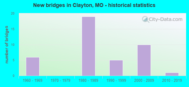
- New bridges - historical statistics
- 61960-1969
- 191980-1989
- 51990-1999
- 102000-2009
- 12010-2019
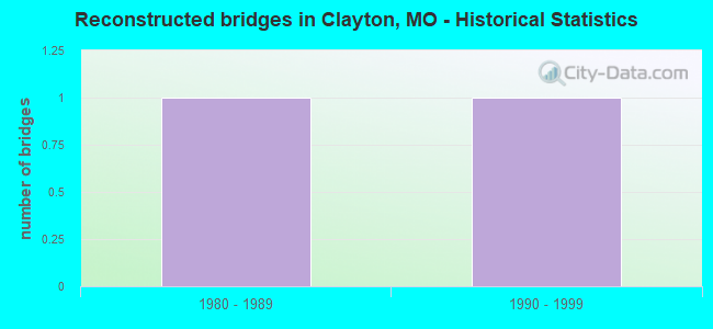
- Reconstructed bridges - Historical Statistics
- 11980-1989
- 11990-1999
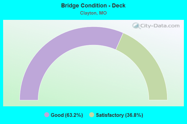
- Bridge Condition - Deck
- 63.2%Good
- 36.8%Satisfactory
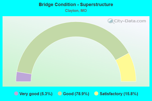
- Bridge Condition - Superstructure
- 5.3%Very good
- 78.9%Good
- 15.8%Satisfactory
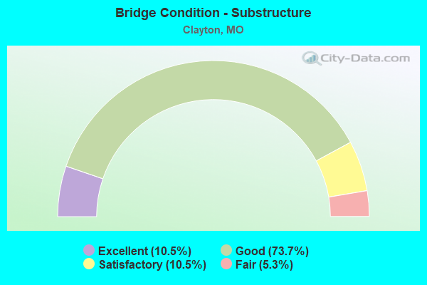
- Bridge Condition - Substructure
- 10.5%Excellent
- 73.7%Good
- 10.5%Satisfactory
- 5.3%Fair
Find on map >> Show street view
Structure Number: 2414, Location: S 16 T 45 N R 6 E (Lat: 38.637942, Lng: -90.343917), Route carried "on" structure: Interstate 170, Year Built: 1968, Year Reconstructed: 1986, Status: Open, Structure Length: 2.90m (9.51ft), Average Daily Traffic: 45,691 (year 2021), Truck Traffic: 4%, Average Future Daily Traffic: 57,114 (year 2041), Design Load: HS 20+Mod, Features Intersected: CST CLAYTON RD
Minimum Vertical Clearance: 30+ m (98+ ft), Kilometerpoint: 16.892, Lanes on structure: 3, Lanes under structure: 5, Base Highway Network: Yes, Owner: State Highway Agency, Approaching Roadway Width: 14.9m (48.9ft), Skew: 12 degrees, Material/Design: Steel, Design/Construction: Stringer/Multi-beam, Number Of Spans In Main Unit: 1, Length of Maximum Span: 27.4m (89.9ft), Curb-To-Curb Width: 12.4m (40.7ft), Out-to-Out Width: 13.3m (43.6ft)
Condition: Deck: Satisfactory, Superstructure: Good, Substructure: Satisfactory, Operating Rating: 66.6 metric tons, Method Used To Determine Operating Rating: Load Factor (LF), Inventory Rating: 39.6 metric tons, Method Used To Determine Inventory Rating: Load Factor (LF), Structural Evaluation: Equal to present minimum criteria, Deck Geometry: High priority of replacement, Underclear: High priority of corrective action, Approach Roadway Alignment: Better than present minimum criteria, Length Of Structure Improvement: 0.38m (1.25ft), Designated Inspection Frequency: Every 24 months, Inspection Date: October 2020, Bridge Improvement Cost: $403,000, Roadway Improvement Cost: $40,000, Total Project Cost: $604,000 ( Estimate for 2022), Deck Structure Type: Concrete Cast-file-Place, Wearing Surface/Protective System: Wearing Surface: Monolithic Concrete, Deck Protection: Epoxy Coated Reinforcing
Find on map >> Show street view
Structure Number: 30512, Location: S 11 T 43 N R 31 W (Lat: 38.543456, Lng: -94.307756), Route carried "on" structure: County highway , Year Built: 2007, Status: Open, Structure Length: 3.41m (11.19ft), Average Daily Traffic: 25 (year 2021), Truck Traffic: 10%, Average Future Daily Traffic: 40 (year 2041), Design Load: HS 20, Features Intersected: 8 MILE CR, Facility Carried by Structure: 317TH TERRACE ST
Minimum Vertical Clearance: 30+ m (98+ ft), Kilometerpoint: 0.000, Lanes on structure: 2, Owner: County Highway Agency, Approaching Roadway Width: 7.3m (24.0ft), Skew: 3 degrees, Material/Design: Steel, Design/Construction: Stringer/Multi-beam, Number Of Spans In Main Unit: 3, Length of Maximum Span: 14.6m (47.9ft), Curb-To-Curb Width: 7.3m (24.0ft), Out-to-Out Width: 7.5m (24.6ft)
Condition: Deck: Good, Superstructure: Good, Substructure: Excellent, Channel: Satisfactory, Operating Rating: 72.9 metric tons, Method Used To Determine Operating Rating: Load Factor (LF), Inventory Rating: 43.2 metric tons, Method Used To Determine Inventory Rating: Load Factor (LF), Structural Evaluation: Better than present minimum criteria, Deck Geometry: Equal to present minimum criteria, Waterway Adequacy: Superior to present desirable criteria, Approach Roadway Alignment: Equal to present desirable criteria, Designated Inspection Frequency: Every 24 months, Inspection Date: April 2021, Deck Structure Type: Concrete Cast-file-Place, Wearing Surface/Protective System: Wearing Surface: Monolithic Concrete
Find on map >> Show street view
Structure Number: 31786, Location: S 15 T 45 N R 6 E (Lat: 38.646206, Lng: -90.346244), Route carried "on" structure: County highway 141, Year Built: 2005, Status: Posted for load, Structure Length: 1.46m (4.79ft), Average Daily Traffic: 20,527 (year 2020), Truck Traffic: 5%, Average Future Daily Traffic: 27,711 (year 2040), Design Load: HS 25 or greater, Features Intersected: SHAW PARK DR, Facility Carried by Structure: FOREST PARK DRIVE
Minimum Vertical Clearance: 30+ m (98+ ft), Kilometerpoint: 0.000, Lanes on structure: 5, Lanes under structure: 2, Owner: County Highway Agency, Approaching Roadway Width: 8.5m (27.9ft), Skew: 31 degrees, Material/Design: Prestressed concrete, Design/Construction: Box Beam or Girders - Multiple, Number Of Spans In Main Unit: 1, Length of Maximum Span: 14.5m (47.6ft), Curb-To-Curb Width: 8.1m (26.6ft), Out-to-Out Width: 21.3m (69.9ft)
Condition: Deck: Good, Superstructure: Good, Substructure: Good, Operating Rating: 99.0 metric tons, Method Used To Determine Operating Rating: Load Factor (LF), Inventory Rating: 59.4 metric tons, Method Used To Determine Inventory Rating: Load Factor (LF), Structural Evaluation: Better than present minimum criteria, Deck Geometry: High priority of replacement, Underclear: High priority of corrective action, Approach Roadway Alignment: Equal to present minimum criteria, Length Of Structure Improvement: 0.21m (0.69ft), Designated Inspection Frequency: Every 24 months, Inspection Date: May 2021, Bridge Improvement Cost: $394,000, Roadway Improvement Cost: $39,000, Total Project Cost: $591,000 ( Estimate for 2022), Deck Structure Type: Other, Wearing Surface/Protective System: Wearing Surface: Bituminous, Membrane: Other, Deck Protection: Epoxy Coated Reinforcing
Find on map >> Show street view
Structure Number: 31787, Location: S 15 T 45 N R 6 E (Lat: 38.645503, Lng: -90.342247), Route carried "on" structure: County highway , Year Built: 2005, Status: Posted for load, Structure Length: 7.28m (23.88ft), Average Daily Traffic: 20,527 (year 2020), Truck Traffic: 5%, Average Future Daily Traffic: 27,711 (year 2040), Design Load: HS 20, Features Intersected: BRENTWOOD BLVD, Facility Carried by Structure: FOREST PARK PKWY E
Minimum Vertical Clearance: 30+ m (98+ ft), Kilometerpoint: 0.000, Lanes on structure: 3, Lanes under structure: 6, Owner: County Highway Agency, Approaching Roadway Width: 11.6m (38.1ft), Skew: 31 degrees, Material/Design: Steel continuous, Design/Construction: Stringer/Multi-beam, Number Of Spans In Main Unit: 3, Length of Maximum Span: 32.5m (106.6ft), Curb-To-Curb Width: 11.6m (38.1ft), Out-to-Out Width: 12.4m (40.7ft)
Condition: Deck: Good, Superstructure: Good, Substructure: Good, Inventory Rating: 74.7 metric tons, Method Used To Determine Inventory Rating: Load Factor (LF), Structural Evaluation: Better than present minimum criteria, Deck Geometry: High priority of replacement, Underclear: High priority of corrective action, Approach Roadway Alignment: Equal to present desirable criteria, Length Of Structure Improvement: 0.83m (2.72ft), Designated Inspection Frequency: Every 24 months, Inspection Date: May 2021, Bridge Improvement Cost: $877,000, Roadway Improvement Cost: $88,000, Total Project Cost: $1,315,000 ( Estimate for 2022), Deck Structure Type: Concrete Cast-file-Place, Wearing Surface/Protective System: Wearing Surface: Monolithic Concrete, Membrane: Other, Deck Protection: Epoxy Coated Reinforcing
Find on map >> Show street view
Structure Number: 31788, Location: S 16 T 45 N R 6 E (Lat: 38.645717, Lng: -90.342147), Route carried "on" structure: County highway , Year Built: 2005, Status: Posted for load, Structure Length: 3.25m (10.66ft), Average Daily Traffic: 16,983 (year 2020), Truck Traffic: 5%, Average Future Daily Traffic: 22,927 (year 2040), Design Load: HS 25 or greater, Features Intersected: BRENTWOOD BLVD, Facility Carried by Structure: FOREST PARK PKWY W
Minimum Vertical Clearance: 30+ m (98+ ft), Kilometerpoint: 0.000, Lanes on structure: 3, Lanes under structure: 6, Owner: County Highway Agency, Approaching Roadway Width: 11.6m (38.1ft), Skew: 31 degrees, Material/Design: Steel continuous, Design/Construction: Stringer/Multi-beam, Number Of Spans In Main Unit: 3, Length of Maximum Span: 32.5m (106.6ft), Curb-To-Curb Width: 11.6m (38.1ft), Out-to-Out Width: 12.4m (40.7ft)
Condition: Deck: Good, Superstructure: Good, Substructure: Good, Inventory Rating: 74.7 metric tons, Method Used To Determine Inventory Rating: Load Factor (LF), Structural Evaluation: Better than present minimum criteria, Deck Geometry: High priority of replacement, Underclear: High priority of corrective action, Approach Roadway Alignment: Equal to present desirable criteria, Length Of Structure Improvement: 0.41m (1.35ft), Designated Inspection Frequency: Every 24 months, Inspection Date: May 2021, Bridge Improvement Cost: $435,000, Roadway Improvement Cost: $44,000, Total Project Cost: $653,000 ( Estimate for 2022), Deck Structure Type: Concrete Cast-file-Place, Wearing Surface/Protective System: Wearing Surface: Monolithic Concrete, Membrane: Other, Deck Protection: Epoxy Coated Reinforcing
Find on map >> Show street view
Structure Number: 31789, Location: S 15 T 45 N R 6 E (Lat: 38.645697, Lng: -90.338950), Route carried "on" structure: County highway , Year Built: 2005, Status: Posted for load, Structure Length: 14.50m (47.57ft), Average Daily Traffic: 7,797 (year 2020), Truck Traffic: 1%, Average Future Daily Traffic: 10,526 (year 2040), Design Load: HS 25 or greater, Features Intersected: FOREST PARK PKWY, SHAW P, Facility Carried by Structure: S CENTRAL AV-RMP C
Minimum Vertical Clearance: 30+ m (98+ ft), Kilometerpoint: 0.000, Lanes on structure: 1, Lanes under structure: 4, Owner: County Highway Agency, Approaching Roadway Width: 7.5m (24.6ft), Material/Design: Steel continuous, Design/Construction: Stringer/Multi-beam, Number Of Spans In Main Unit: 5, Length of Maximum Span: 31.1m (102.0ft), Curb-To-Curb Width: 5.5m (18.0ft), Out-to-Out Width: 7.5m (24.6ft)
Condition: Deck: Good, Superstructure: Good, Substructure: Good, Operating Rating: 96.3 metric tons, Method Used To Determine Operating Rating: Load Factor (LF), Inventory Rating: 57.6 metric tons, Method Used To Determine Inventory Rating: Load Factor (LF), Structural Evaluation: Better than present minimum criteria, Deck Geometry: High priority of replacement, Underclear: High priority of corrective action, Approach Roadway Alignment: Equal to present desirable criteria, Designated Inspection Frequency: Every 24 months, Inspection Date: May 2021, Deck Structure Type: Concrete Cast-file-Place, Wearing Surface/Protective System: Wearing Surface: Monolithic Concrete, Membrane: Other, Deck Protection: Epoxy Coated Reinforcing
Find on map >> Show street view
Structure Number: 3179, Location: S 15 T 45 N R 6 E (Lat: 38.645986, Lng: -90.337400), Route carried "on" structure: County highway , Year Built: 2005, Status: Posted for load, Structure Length: 2.90m (9.51ft), Average Daily Traffic: 1,322 (year 2020), Truck Traffic: 5%, Average Future Daily Traffic: 1,785 (year 2040), Design Load: HS 25 or greater, Features Intersected: FOREST PARK PKWY, Facility Carried by Structure: BEMISTON AVE-RMP D
Minimum Vertical Clearance: 30+ m (98+ ft), Kilometerpoint: 0.000, Lanes on structure: 1, Lanes under structure: 4, Owner: County Highway Agency, Approaching Roadway Width: 12.9m (42.3ft), Skew: 2 degrees, Material/Design: Prestressed concrete, Design/Construction: Stringer/Multi-beam, Number Of Spans In Main Unit: 1, Length of Maximum Span: 27.8m (91.2ft), Curb-To-Curb Width: 7.6m (24.9ft), Out-to-Out Width: 9.1m (29.9ft)
Condition: Deck: Good, Superstructure: Good, Substructure: Good, Inventory Rating: 70.2 metric tons, Method Used To Determine Inventory Rating: Load Factor (LF), Structural Evaluation: Better than present minimum criteria, Deck Geometry: Meets minimum limits, Underclear: High priority of corrective action, Approach Roadway Alignment: Equal to present desirable criteria, Designated Inspection Frequency: Every 24 months, Inspection Date: May 2021, Deck Structure Type: Concrete Cast-file-Place, Wearing Surface/Protective System: Wearing Surface: Monolithic Concrete, Membrane: Other, Deck Protection: Epoxy Coated Reinforcing
Find on map >> Show street view
Structure Number: 31792, Location: S 15 T 45 N R 6 E (Lat: 38.648681, Lng: -90.328172), Route carried "on" structure: County highway , Year Built: 2004, Status: Posted for load, Structure Length: 19.68m (64.57ft), Average Daily Traffic: 7,898 (year 2020), Truck Traffic: 5%, Average Future Daily Traffic: 10,662 (year 2040), Design Load: HS 25 or greater, Features Intersected: FORSYTH BLVD, Facility Carried by Structure: FOREST PARK PKWY E
Minimum Vertical Clearance: 30+ m (98+ ft), Kilometerpoint: 0.000, Lanes on structure: 2, Lanes under structure: 4, Owner: County Highway Agency, Approaching Roadway Width: 7.9m (25.9ft), Skew: 1 degrees, Material/Design: Steel continuous, Design/Construction: Stringer/Multi-beam, Number Of Spans In Main Unit: 8, Length of Maximum Span: 28.4m (93.2ft), Curb-To-Curb Width: 7.9m (25.9ft), Out-to-Out Width: 8.7m (28.5ft)
Condition: Deck: Good, Superstructure: Good, Substructure: Good, Operating Rating: 72.0 metric tons, Method Used To Determine Operating Rating: Load Factor (LF), Inventory Rating: 43.2 metric tons, Method Used To Determine Inventory Rating: Load Factor (LF), Structural Evaluation: Better than present minimum criteria, Deck Geometry: High priority of replacement, Underclear: Meets minimum limits, Approach Roadway Alignment: Equal to present desirable criteria, Length Of Structure Improvement: 2.02m (6.63ft), Designated Inspection Frequency: Every 24 months, Inspection Date: May 2021, Bridge Improvement Cost: $1,650,000, Roadway Improvement Cost: $165,000, Total Project Cost: $2,475,000 ( Estimate for 2022), Deck Structure Type: Concrete Cast-file-Place, Wearing Surface/Protective System: Wearing Surface: Monolithic Concrete, Deck Protection: Epoxy Coated Reinforcing
Find on map >> Show street view
Structure Number: 31793, Location: S 15 T 45 N R 6 E (Lat: 38.648753, Lng: -90.328261), Route carried "on" structure: County highway , Year Built: 2004, Status: Posted for load, Structure Length: 19.66m (64.50ft), Average Daily Traffic: 9,195 (year 2020), Truck Traffic: 5%, Average Future Daily Traffic: 12,413 (year 2040), Design Load: HS 25 or greater, Features Intersected: FORSYTH BLVD, Facility Carried by Structure: FOREST PARK PKWY W
Minimum Vertical Clearance: 30+ m (98+ ft), Kilometerpoint: 0.000, Lanes on structure: 2, Lanes under structure: 4, Owner: County Highway Agency, Approaching Roadway Width: 7.9m (25.9ft), Skew: 1 degrees, Material/Design: Steel continuous, Design/Construction: Stringer/Multi-beam, Number Of Spans In Main Unit: 8, Length of Maximum Span: 31.4m (103.0ft), Curb-To-Curb Width: 7.9m (25.9ft), Out-to-Out Width: 8.7m (28.5ft)
Condition: Deck: Good, Superstructure: Good, Substructure: Good, Operating Rating: 72.0 metric tons, Method Used To Determine Operating Rating: Load Factor (LF), Inventory Rating: 43.2 metric tons, Method Used To Determine Inventory Rating: Load Factor (LF), Structural Evaluation: Better than present minimum criteria, Deck Geometry: High priority of replacement, Underclear: Meets minimum limits, Approach Roadway Alignment: Equal to present desirable criteria, Length Of Structure Improvement: 2.02m (6.63ft), Designated Inspection Frequency: Every 24 months, Inspection Date: May 2021, Bridge Improvement Cost: $1,650,000, Roadway Improvement Cost: $165,000, Total Project Cost: $2,475,000 ( Estimate for 2022), Deck Structure Type: Concrete Cast-file-Place, Wearing Surface/Protective System: Wearing Surface: Monolithic Concrete, Deck Protection: Epoxy Coated Reinforcing
Find on map >> Show street view
Structure Number: 31795, Location: S 15 T 45 N R 6 E (Lat: 38.646733, Lng: -90.334497), Route carried "on" structure: County highway , Year Built: 2005, Status: Posted for load, Structure Length: 5.41m (17.75ft), Average Daily Traffic: 11,603 (year 2020), Truck Traffic: 5%, Average Future Daily Traffic: 15,664 (year 2040), Design Load: HS 25 or greater, Features Intersected: HANLEY RD, Facility Carried by Structure: FOREST PARK PKWY E
Minimum Vertical Clearance: 30+ m (98+ ft), Kilometerpoint: 7.242, Lanes on structure: 2, Lanes under structure: 5, Owner: County Highway Agency, Approaching Roadway Width: 11.6m (38.1ft), Skew: 30 degrees, Material/Design: Steel continuous, Design/Construction: Stringer/Multi-beam, Number Of Spans In Main Unit: 3, Length of Maximum Span: 22.9m (75.1ft), Curb-To-Curb Width: 11.6m (38.1ft), Out-to-Out Width: 12.4m (40.7ft)
Condition: Deck: Satisfactory, Superstructure: Good, Substructure: Good, Operating Rating: 92.7 metric tons, Method Used To Determine Operating Rating: Load Factor (LF), Inventory Rating: 55.8 metric tons, Method Used To Determine Inventory Rating: Load Factor (LF), Structural Evaluation: Better than present minimum criteria, Deck Geometry: Better than present minimum criteria, Underclear: Meets minimum limits, Approach Roadway Alignment: Equal to present desirable criteria, Designated Inspection Frequency: Every 24 months, Inspection Date: May 2021, Deck Structure Type: Concrete Cast-file-Place, Wearing Surface/Protective System: Wearing Surface: Monolithic Concrete, Membrane: Other, Deck Protection: Epoxy Coated Reinforcing
Find on map >> Show street view
Structure Number: 31796, Location: S 15 T 45 N R 6 E (Lat: 38.646911, Lng: -90.334469), Route carried "on" structure: County highway , Year Built: 2005, Status: Posted for load, Structure Length: 5.41m (17.75ft), Average Daily Traffic: 9,479 (year 2020), Truck Traffic: 5%, Average Future Daily Traffic: 12,797 (year 2040), Design Load: HS 25 or greater, Features Intersected: HANLEY RD, Facility Carried by Structure: FOREST PARK PKWY W
Minimum Vertical Clearance: 30+ m (98+ ft), Kilometerpoint: 7.242, Lanes on structure: 2, Lanes under structure: 5, Owner: County Highway Agency, Approaching Roadway Width: 11.6m (38.1ft), Material/Design: Steel continuous, Design/Construction: Stringer/Multi-beam, Number Of Spans In Main Unit: 3, Length of Maximum Span: 22.9m (75.1ft), Curb-To-Curb Width: 11.6m (38.1ft), Out-to-Out Width: 12.4m (40.7ft)
Condition: Deck: Good, Superstructure: Good, Substructure: Good, Operating Rating: 92.7 metric tons, Method Used To Determine Operating Rating: Load Factor (LF), Inventory Rating: 55.8 metric tons, Method Used To Determine Inventory Rating: Load Factor (LF), Structural Evaluation: Better than present minimum criteria, Deck Geometry: Better than present minimum criteria, Underclear: Meets minimum limits, Approach Roadway Alignment: Equal to present desirable criteria, Designated Inspection Frequency: Every 24 months, Inspection Date: May 2021, Deck Structure Type: Concrete Cast-file-Place, Wearing Surface/Protective System: Wearing Surface: Monolithic Concrete, Membrane: Other, Deck Protection: Epoxy Coated Reinforcing
Find on map >> Show street view
Structure Number: 34545, Location: S 378 T 45 N R 6 E (Lat: 38.647072, Lng: -90.312383), Route carried "on" structure: City street , Year Built: 2013, Status: Open, Structure Length: 1.05m (3.44ft), Average Daily Traffic: 10,152 (year 2020), Truck Traffic: 1%, Average Future Daily Traffic: 13,705 (year 2040), Features Intersected: PEDESTRIAN WALKWAY, Facility Carried by Structure: FORSYTH BLVD
Minimum Vertical Clearance: 30+ m (98+ ft), Kilometerpoint: 0.000, Lanes on structure: 3, Owner: City or Municipal Highway Agency, Maintenance Responsibility: Private, Approaching Roadway Width: 12.2m (40.0ft), Material/Design: Concrete, Design/Construction: Slab, Number Of Spans In Main Unit: 1, Length of Maximum Span: 9.8m (32.2ft), Curb or Sidewalk Widths: Left: 4.7m (15.4ft), Right: 2.0m (6.6ft), Curb-To-Curb Width: 12.2m (40.0ft), Out-to-Out Width: 19.5m (64.0ft)
Condition: Deck: Good, Superstructure: Good, Substructure: Excellent, Operating Rating: 54.9 metric tons, Method Used To Determine Operating Rating: Load and Resistance Factor (LRFR), Inventory Rating: 33.3 metric tons, Method Used To Determine Inventory Rating: Load and Resistance Factor (LRFR), Structural Evaluation: Better than present minimum criteria, Deck Geometry: Meets minimum limits, Approach Roadway Alignment: Equal to present desirable criteria, Designated Inspection Frequency: Every 24 months, Inspection Date: November 2021, Deck Structure Type: Other, Wearing Surface/Protective System: Wearing Surface: Monolithic Concrete, Membrane: Other, Deck Protection: Epoxy Coated Reinforcing
Find on map >> Show street view
Structure Number: 375, Location: S 12 T 27 N R 31 W (Lat: 37.081494, Lng: -94.275544), Route carried "on" structure: Interstate 44, Year Built: 1962, Year Reconstructed: 2003, Status: Open, Structure Length: 6.00m (19.69ft), Average Daily Traffic: 16,855 (year 2021), Truck Traffic: 26%, Average Future Daily Traffic: 30,339 (year 2041), Design Load: HS 20, Features Intersected: JONES CR
Minimum Vertical Clearance: 30+ m (98+ ft), Kilometerpoint: 32.992, Lanes on structure: 2, Base Highway Network: Yes, Owner: State Highway Agency, Approaching Roadway Width: 11.6m (38.1ft), Material/Design: Steel continuous, Design/Construction: Stringer/Multi-beam, Number Of Spans In Main Unit: 4, Length of Maximum Span: 16.2m (53.1ft), Curb-To-Curb Width: 11.3m (37.1ft), Out-to-Out Width: 12.2m (40.0ft)
Condition: Deck: Satisfactory, Superstructure: Good, Substructure: Satisfactory, Channel: Satisfactory, Operating Rating: 50.4 metric tons, Method Used To Determine Operating Rating: Load Factor (LF), Inventory Rating: 30.6 metric tons, Method Used To Determine Inventory Rating: Load Factor (LF), Structural Evaluation: Equal to present minimum criteria, Deck Geometry: Somewhat better than minimum adequacy, Waterway Adequacy: Equal to present minimum criteria, Approach Roadway Alignment: Equal to present desirable criteria, Designated Inspection Frequency: Every 24 months, Inspection Date: August 2021, Deck Structure Type: Concrete Cast-file-Place, Wearing Surface/Protective System: Wearing Surface: Low Slump Concrete
Find on map >> Show street view
Structure Number: 3751, Location: S 15 T 45 N R 5 E (Lat: 38.638669, Lng: -90.443528), Route carried "on" structure: Interstate 64, Year Built: 1991, Status: Open, Structure Length: 5.49m (18.01ft), Average Daily Traffic: 80,988 (year 2021), Truck Traffic: 12%, Average Future Daily Traffic: 101,235 (year 2041), Design Load: HS 20+Mod, Features Intersected: RT JJ
Minimum Vertical Clearance: 30+ m (98+ ft), Kilometerpoint: 23.495, Lanes on structure: 5, Lanes under structure: 6, Base Highway Network: Yes, Owner: State Highway Agency, Approaching Roadway Width: 22.9m (75.1ft), Material/Design: Prestressed concrete continuous, Design/Construction: Stringer/Multi-beam, Number Of Spans In Main Unit: 3, Length of Maximum Span: 29.0m (95.1ft), Curb-To-Curb Width: 21.6m (70.9ft), Out-to-Out Width: 22.4m (73.5ft)
Condition: Deck: Good, Superstructure: Satisfactory, Substructure: Good, Operating Rating: 74.7 metric tons, Method Used To Determine Operating Rating: Load Factor (LF), Inventory Rating: 37.8 metric tons, Method Used To Determine Inventory Rating: Load Factor (LF), Structural Evaluation: Equal to present minimum criteria, Deck Geometry: Meets minimum limits, Underclear: Somewhat better than minimum adequacy, Approach Roadway Alignment: Equal to present desirable criteria, Designated Inspection Frequency: Every 24 months, Inspection Date: October 2020, Deck Structure Type: Concrete Cast-file-Place, Wearing Surface/Protective System: Wearing Surface: Monolithic Concrete, Membrane: Other, Deck Protection: Epoxy Coated Reinforcing
Find on map >> Show street view
Structure Number: 3808, Location: S 15 T 45 N R 5 E (Lat: 38.639050, Lng: -90.449647), Route carried "on" structure: Interstate 64, Year Built: 1988, Status: Open, Structure Length: 37.67m (123.59ft), Average Daily Traffic: 78,262 (year 2021), Truck Traffic: 12%, Average Future Daily Traffic: 97,828 (year 2041), Design Load: HS 20+Mod, Features Intersected: IS 270, RP IS270E TO IS6
Minimum Vertical Clearance: 30+ m (98+ ft), Kilometerpoint: 23.842, Lanes on structure: 3, Lanes under structure: 16, Base Highway Network: Yes, Owner: State Highway Agency, Approaching Roadway Width: 15.8m (51.8ft), Skew: 2 degrees, Material/Design: Steel continuous, Design/Construction: Stringer/Multi-beam, Number Of Spans In Main Unit: 8, Number Of Approach Spans: 5, Length of Maximum Span: 43.9m (144.0ft), Curb-To-Curb Width: 15.5m (50.9ft), Out-to-Out Width: 16.3m (53.5ft)
Condition: Deck: Satisfactory, Superstructure: Satisfactory, Substructure: Fair, Operating Rating: 59.4 metric tons, Method Used To Determine Operating Rating: Load Factor (LF), Inventory Rating: 36.0 metric tons, Method Used To Determine Inventory Rating: Load Factor (LF), Structural Evaluation: Somewhat better than minimum adequacy, Deck Geometry: Somewhat better than minimum adequacy, Underclear: Somewhat better than minimum adequacy, Approach Roadway Alignment: Equal to present desirable criteria, Designated Inspection Frequency: Every 24 months, Inspection Date: September 2020, Deck Structure Type: Concrete Cast-file-Place, Wearing Surface/Protective System: Wearing Surface: Monolithic Concrete, Deck Protection: Epoxy Coated Reinforcing
Find on map >> Show street view
Structure Number: 381, Location: S 15 T 45 N R 5 E (Lat: 38.638075, Lng: -90.449122), Route carried "on" structure: Interstate 64, Year Built: 1988, Status: Open, Structure Length: 52.09m (170.90ft), Average Daily Traffic: 64,195 (year 2021), Truck Traffic: 12%, Average Future Daily Traffic: 80,244 (year 2041), Design Load: HS 20+Mod, Features Intersected: IS 270, RP IS270E TO IS6
Minimum Vertical Clearance: 30+ m (98+ ft), Kilometerpoint: 41.423, Lanes on structure: 3, Lanes under structure: 12, Base Highway Network: Yes, Owner: State Highway Agency, Approaching Roadway Width: 19.5m (64.0ft), Skew: 1 degrees, Material/Design: Steel continuous, Design/Construction: Stringer/Multi-beam, Number Of Spans In Main Unit: 10, Number Of Approach Spans: 7, Length of Maximum Span: 43.3m (142.1ft), Curb-To-Curb Width: 17.9m (58.7ft), Out-to-Out Width: 18.7m (61.4ft)
Condition: Deck: Satisfactory, Superstructure: Good, Substructure: Good, Operating Rating: 55.8 metric tons, Method Used To Determine Operating Rating: Load Factor (LF), Inventory Rating: 32.4 metric tons, Method Used To Determine Inventory Rating: Load Factor (LF), Structural Evaluation: Better than present minimum criteria, Deck Geometry: Better than present minimum criteria, Underclear: Meets minimum limits, Approach Roadway Alignment: Equal to present desirable criteria, Designated Inspection Frequency: Every 24 months, Inspection Date: September 2020, Deck Structure Type: Concrete Cast-file-Place, Wearing Surface/Protective System: Wearing Surface: Monolithic Concrete, Deck Protection: Epoxy Coated Reinforcing
Find on map >> Show street view
Structure Number: 3811, Location: S 15 T 45 N R 5 E (Lat: 38.637353, Lng: -90.449392), Route carried "on" structure: Ramp State highway , Year Built: 1988, Status: Open, Structure Length: 32.74m (107.41ft), Average Daily Traffic: 12,920 (year 2021), Truck Traffic: 3%, Average Future Daily Traffic: 16,150 (year 2041), Design Load: HS 20+Mod, Features Intersected: IS 270, RP IS270E TO IS6, Facility Carried by Structure: RP IS64E TO IS270E
Minimum Vertical Clearance: 30+ m (98+ ft), Kilometerpoint: 0.459, Lanes on structure: 1, Lanes under structure: 11, Base Highway Network: Yes, Owner: State Highway Agency, Approaching Roadway Width: 8.5m (27.9ft), Skew: 1 degrees, Material/Design: Steel continuous, Design/Construction: Stringer/Multi-beam, Number Of Spans In Main Unit: 7, Number Of Approach Spans: 4, Length of Maximum Span: 45.5m (149.3ft), Curb-To-Curb Width: 8.2m (26.9ft), Out-to-Out Width: 9.0m (29.5ft)
Condition: Deck: Good, Superstructure: Very good, Substructure: Good, Operating Rating: 57.6 metric tons, Method Used To Determine Operating Rating: Load Factor (LF), Inventory Rating: 31.5 metric tons, Method Used To Determine Inventory Rating: Load Factor (LF), Structural Evaluation: Better than present minimum criteria, Deck Geometry: Superior to present desirable criteria, Underclear: Meets minimum limits, Approach Roadway Alignment: Equal to present desirable criteria, Designated Inspection Frequency: Every 24 months, Inspection Date: March 2021, Deck Structure Type: Concrete Cast-file-Place, Wearing Surface/Protective System: Wearing Surface: Monolithic Concrete, Deck Protection: Epoxy Coated Reinforcing
Find on map >> Show street view
Structure Number: 3814, Location: S 2002 T 45 N R 4 E (Lat: 38.647481, Lng: -90.563228), Route carried "on" structure: State highway 340, Year Built: 1990, Status: Open, Structure Length: 5.27m (17.29ft), Average Daily Traffic: 19,391 (year 2021), Truck Traffic: 4%, Average Future Daily Traffic: 27,147 (year 2041), Design Load: HS 20+Mod, Features Intersected: CST CHESTERFIELD PKWY EA
Minimum Vertical Clearance: 30+ m (98+ ft), Kilometerpoint: 6.622, Lanes on structure: 2, Lanes under structure: 5, Base Highway Network: Yes, Owner: State Highway Agency, Approaching Roadway Width: 15.8m (51.8ft), Material/Design: Prestressed concrete continuous, Design/Construction: Stringer/Multi-beam, Number Of Spans In Main Unit: 3, Length of Maximum Span: 27.4m (89.9ft), Curb or Sidewalk Widths: Left: 0.2m (0.7ft), Right: 0.2m (0.7ft), Curb-To-Curb Width: 11.8m (38.7ft), Out-to-Out Width: 12.7m (41.7ft)
Condition: Deck: Satisfactory, Superstructure: Good, Substructure: Good, Operating Rating: 76.5 metric tons, Method Used To Determine Operating Rating: Load Factor (LF), Inventory Rating: 43.2 metric tons, Method Used To Determine Inventory Rating: Load Factor (LF), Structural Evaluation: Better than present minimum criteria, Deck Geometry: Better than present minimum criteria, Underclear: Better than present minimum criteria, Approach Roadway Alignment: Equal to present desirable criteria, Designated Inspection Frequency: Every 24 months, Inspection Date: July 2020, Deck Structure Type: Concrete Cast-file-Place, Wearing Surface/Protective System: Wearing Surface: Monolithic Concrete, Deck Protection: Epoxy Coated Reinforcing
Find on map >> Show street view
Structure Number: 3815, Location: S 2002 T 45 N R 4 E (Lat: 38.647569, Lng: -90.563472), Route carried "on" structure: State highway 340, Year Built: 1990, Status: Open, Structure Length: 5.27m (17.29ft), Average Daily Traffic: 22,344 (year 2021), Truck Traffic: 3%, Average Future Daily Traffic: 31,282 (year 2041), Design Load: HS 20+Mod, Features Intersected: CST CHESTERFIELD PKWY EA
Minimum Vertical Clearance: 30+ m (98+ ft), Kilometerpoint: 24.346, Lanes on structure: 3, Lanes under structure: 5, Base Highway Network: Yes, Owner: State Highway Agency, Approaching Roadway Width: 15.8m (51.8ft), Material/Design: Prestressed concrete continuous, Design/Construction: Stringer/Multi-beam, Number Of Spans In Main Unit: 3, Length of Maximum Span: 27.4m (89.9ft), Curb or Sidewalk Widths: Left: 0.2m (0.7ft), Right: 0.2m (0.7ft), Curb-To-Curb Width: 14.3m (46.9ft), Out-to-Out Width: 15.1m (49.5ft)
Condition: Deck: Satisfactory, Superstructure: Satisfactory, Substructure: Good, Operating Rating: 79.2 metric tons, Method Used To Determine Operating Rating: Load Factor (LF), Inventory Rating: 27.0 metric tons, Method Used To Determine Inventory Rating: Load Factor (LF), Structural Evaluation: Equal to present minimum criteria, Deck Geometry: Somewhat better than minimum adequacy, Underclear: Superior to present desirable criteria, Approach Roadway Alignment: Equal to present desirable criteria, Designated Inspection Frequency: Every 24 months, Inspection Date: July 2020, Deck Structure Type: Concrete Cast-file-Place, Wearing Surface/Protective System: Wearing Surface: Monolithic Concrete, Deck Protection: Epoxy Coated Reinforcing
Find on map >> Show street view
Structure Number: 2412, Location: S 16 T 45 N R 6 E (Lat: 38.635442, Lng: -90.343692), Route carried "under" structure: City street , Year Built: 1968, Structure Length: 0. m, Average Daily Traffic: 5,088 (year 2021), Truck Traffic: 5%, Features Intersected: CST GALLERIA PKWY, Facility Carried by Structure: IS 170 E
Minimum Vertical Clearance: 4.37m (14.34ft), Kilometerpoint: 0.257, Lanes on structure: 3, Lanes under structure: 4, Material/Design: Steel, Design/Construction: Stringer/Multi-beam, Length of Maximum Span: 20.4m (66.9ft)
Find on map >> Show street view
Structure Number: 2413, Location: S 16 T 45 N R 6 E (Lat: 38.635419, Lng: -90.343553), Route carried "under" structure: City street , Year Built: 1968, Structure Length: 0. m, Average Daily Traffic: 5,088 (year 2021), Truck Traffic: 5%, Features Intersected: CST GALLERIA PKWY, Facility Carried by Structure: IS 170 W
Minimum Vertical Clearance: 4.44m (14.57ft), Kilometerpoint: 0.270, Lanes on structure: 3, Lanes under structure: 4, Material/Design: Steel, Design/Construction: Stringer/Multi-beam, Length of Maximum Span: 20.4m (66.9ft)
Find on map >> Show street view
Structure Number: 2414, Location: S 16 T 45 N R 6 E (Lat: 38.637942, Lng: -90.343917), Route carried "under" structure: City street , Year Built: 1968, Structure Length: 0. m, Average Daily Traffic: 13,616 (year 2021), Truck Traffic: 6%, Features Intersected: CST CLAYTON RD, Facility Carried by Structure: IS 170 E
Minimum Vertical Clearance: 4.24m (13.91ft), Kilometerpoint: 28.242, Lanes on structure: 3, Lanes under structure: 5, Material/Design: Steel, Design/Construction: Stringer/Multi-beam, Length of Maximum Span: 27.4m (89.9ft)
Find on map >> Show street view
Structure Number: 2415, Location: S 16 T 45 N R 6 E (Lat: 38.637922, Lng: -90.343697), Route carried "under" structure: City street , Year Built: 1968, Structure Length: 0. m, Average Daily Traffic: 13,616 (year 2021), Truck Traffic: 6%, Features Intersected: CST CLAYTON RD, Facility Carried by Structure: IS 170 W
Minimum Vertical Clearance: 4.24m (13.91ft), Kilometerpoint: 28.262, Lanes on structure: 4, Lanes under structure: 5, Material/Design: Steel, Design/Construction: Stringer/Multi-beam, Length of Maximum Span: 27.4m (89.9ft)
Find on map >> Show street view
Structure Number: 3808, Location: S 15 T 45 N R 5 E (Lat: 38.639050, Lng: -90.449647), Route carried "under" structure: Interstate 270, Year Built: 1988, Structure Length: 0. m, Average Daily Traffic: 86,420 (year 2021), Truck Traffic: 12%, Features Intersected: IS 270, Facility Carried by Structure: IS 64 W
Minimum Vertical Clearance: 5.61m (18.41ft), Kilometerpoint: 37.137, Lanes on structure: 3, Lanes under structure: 4, Material/Design: Steel continuous, Design/Construction: Stringer/Multi-beam, Length of Maximum Span: 43.9m (144.0ft)
Find on map >> Show street view
Structure Number: 3808, Location: S 15 T 45 N R 5 E (Lat: 38.639050, Lng: -90.449647), Route carried "under" structure: Interstate 270, Year Built: 1988, Structure Length: 0. m, Average Daily Traffic: 92,845 (year 2021), Truck Traffic: 18%, Features Intersected: IS 270, Facility Carried by Structure: IS 64 W
Minimum Vertical Clearance: 5.70m (18.70ft), Kilometerpoint: 20.447, Lanes on structure: 3, Lanes under structure: 4, Material/Design: Steel continuous, Design/Construction: Stringer/Multi-beam, Length of Maximum Span: 43.9m (144.0ft)
Find on map >> Show street view
Structure Number: 3808, Location: S 15 T 45 N R 5 E (Lat: 38.639050, Lng: -90.449647), Route carried "under" structure: Ramp State highway , Year Built: 1988, Structure Length: 0. m, Average Daily Traffic: 17,500 (year 2021), Truck Traffic: 9%, Features Intersected: RP IS270E TO IS64W, Facility Carried by Structure: IS 64 W
Minimum Vertical Clearance: 12.07m (39.60ft), Kilometerpoint: 0.575, Lanes on structure: 3, Lanes under structure: 2, Material/Design: Steel continuous, Design/Construction: Stringer/Multi-beam, Length of Maximum Span: 43.9m (144.0ft)
Find on map >> Show street view
Structure Number: 3808, Location: S 15 T 45 N R 5 E (Lat: 38.639050, Lng: -90.449647), Route carried "under" structure: Ramp State highway , Year Built: 1988, Structure Length: 0. m, Average Daily Traffic: 14,641 (year 2021), Truck Traffic: 8%, Features Intersected: RP IS64W TO IS270W, Facility Carried by Structure: IS 64 W
Minimum Vertical Clearance: 5.00m (16.40ft), Kilometerpoint: 0.591, Lanes on structure: 3, Lanes under structure: 2, Material/Design: Steel continuous, Design/Construction: Stringer/Multi-beam, Length of Maximum Span: 43.9m (144.0ft)
Find on map >> Show street view
Structure Number: 3808, Location: S 15 T 45 N R 5 E (Lat: 38.639050, Lng: -90.449647), Route carried "under" structure: Ramp State highway , Year Built: 1988, Structure Length: 0. m, Average Daily Traffic: 20,502 (year 2021), Truck Traffic: 4%, Features Intersected: RP IS270W TO IS64E, Facility Carried by Structure: IS 64 W
Minimum Vertical Clearance: 12.06m (39.57ft), Kilometerpoint: 0.407, Lanes on structure: 3, Lanes under structure: 2, Material/Design: Steel continuous, Design/Construction: Stringer/Multi-beam, Length of Maximum Span: 43.9m (144.0ft)
Find on map >> Show street view
Structure Number: 381, Location: S 15 T 45 N R 5 E (Lat: 38.638075, Lng: -90.449122), Route carried "under" structure: Ramp State highway , Year Built: 1988, Structure Length: 0. m, Average Daily Traffic: 12,920 (year 2021), Truck Traffic: 3%, Features Intersected: RP IS64E TO IS270E, Facility Carried by Structure: IS 64 E
Minimum Vertical Clearance: 4.65m (15.26ft), Kilometerpoint: 0.777, Lanes on structure: 3, Lanes under structure: 1, Material/Design: Steel continuous, Design/Construction: Stringer/Multi-beam, Length of Maximum Span: 43.3m (142.1ft)
Find on map >> Show street view
Structure Number: 381, Location: S 15 T 45 N R 5 E (Lat: 38.638075, Lng: -90.449122), Route carried "under" structure: Ramp State highway , Year Built: 1988, Structure Length: 0. m, Average Daily Traffic: 14,641 (year 2021), Truck Traffic: 8%, Features Intersected: RP IS64W TO IS270W, Facility Carried by Structure: IS 64 E
Minimum Vertical Clearance: 5.33m (17.49ft), Kilometerpoint: 0.694, Lanes on structure: 3, Lanes under structure: 1, Material/Design: Steel continuous, Design/Construction: Stringer/Multi-beam, Length of Maximum Span: 43.3m (142.1ft)
Find on map >> Show street view
Structure Number: 381, Location: S 15 T 45 N R 5 E (Lat: 38.638075, Lng: -90.449122), Route carried "under" structure: Ramp State highway , Year Built: 1988, Structure Length: 0. m, Average Daily Traffic: 20,502 (year 2021), Truck Traffic: 4%, Features Intersected: RP IS270W TO IS64E, Facility Carried by Structure: IS 64 E
Minimum Vertical Clearance: 12.23m (40.12ft), Kilometerpoint: 0.560, Lanes on structure: 3, Lanes under structure: 1, Material/Design: Steel continuous, Design/Construction: Stringer/Multi-beam, Length of Maximum Span: 43.3m (142.1ft)
Find on map >> Show street view
Structure Number: 381, Location: S 15 T 45 N R 5 E (Lat: 38.638075, Lng: -90.449122), Route carried "under" structure: Ramp State highway , Year Built: 1988, Structure Length: 0. m, Average Daily Traffic: 17,500 (year 2021), Truck Traffic: 9%, Features Intersected: RP IS270E TO IS64W, Facility Carried by Structure: IS 64 E
Minimum Vertical Clearance: 12.22m (40.09ft), Kilometerpoint: 0.431, Lanes on structure: 3, Lanes under structure: 1, Material/Design: Steel continuous, Design/Construction: Stringer/Multi-beam, Length of Maximum Span: 43.3m (142.1ft)
Find on map >> Show street view
Structure Number: 381, Location: S 15 T 45 N R 5 E (Lat: 38.638075, Lng: -90.449122), Route carried "under" structure: Interstate 270, Year Built: 1988, Structure Length: 0. m, Average Daily Traffic: 92,845 (year 2021), Truck Traffic: 18%, Features Intersected: IS 270, Facility Carried by Structure: IS 64 E
Minimum Vertical Clearance: 5.04m (16.54ft), Kilometerpoint: 20.341, Lanes on structure: 3, Lanes under structure: 4, Material/Design: Steel continuous, Design/Construction: Stringer/Multi-beam, Length of Maximum Span: 43.3m (142.1ft)
Find on map >> Show street view
Structure Number: 381, Location: S 15 T 45 N R 5 E (Lat: 38.638075, Lng: -90.449122), Route carried "under" structure: Interstate 270, Year Built: 1988, Structure Length: 0. m, Average Daily Traffic: 89,121 (year 2021), Truck Traffic: 18%, Features Intersected: IS 270, Facility Carried by Structure: IS 64 E
Minimum Vertical Clearance: 4.98m (16.34ft), Kilometerpoint: 37.244, Lanes on structure: 3, Lanes under structure: 4, Material/Design: Steel continuous, Design/Construction: Stringer/Multi-beam, Length of Maximum Span: 43.3m (142.1ft)
Find on map >> Show street view
Structure Number: 3811, Location: S 15 T 45 N R 5 E (Lat: 38.637353, Lng: -90.449392), Route carried "under" structure: Ramp State highway , Year Built: 1988, Structure Length: 0. m, Average Daily Traffic: 14,641 (year 2021), Truck Traffic: 8%, Features Intersected: RP IS64W TO IS270W, Facility Carried by Structure: RP IS64E TO IS270E
Minimum Vertical Clearance: 4.98m (16.34ft), Kilometerpoint: 0.798, Lanes on structure: 1, Lanes under structure: 1, Material/Design: Steel continuous, Design/Construction: Stringer/Multi-beam, Length of Maximum Span: 45.5m (149.3ft)
Find on map >> Show street view
Structure Number: 3811, Location: S 15 T 45 N R 5 E (Lat: 38.637353, Lng: -90.449392), Route carried "under" structure: Ramp State highway , Year Built: 1988, Structure Length: 0. m, Average Daily Traffic: 17,500 (year 2021), Truck Traffic: 9%, Features Intersected: RP IS270E TO IS64W, Facility Carried by Structure: RP IS64E TO IS270E
Minimum Vertical Clearance: 9.53m (31.27ft), Kilometerpoint: 0.369, Lanes on structure: 1, Lanes under structure: 1, Material/Design: Steel continuous, Design/Construction: Stringer/Multi-beam, Length of Maximum Span: 45.5m (149.3ft)
Find on map >> Show street view
Structure Number: 3811, Location: S 15 T 45 N R 5 E (Lat: 38.637353, Lng: -90.449392), Route carried "under" structure: Ramp State highway , Year Built: 1988, Structure Length: 0. m, Average Daily Traffic: 20,502 (year 2021), Truck Traffic: 4%, Features Intersected: RP IS270W TO IS64E, Facility Carried by Structure: RP IS64E TO IS270E
Minimum Vertical Clearance: 6.53m (21.42ft), Kilometerpoint: 0.597, Lanes on structure: 1, Lanes under structure: 1, Material/Design: Steel continuous, Design/Construction: Stringer/Multi-beam, Length of Maximum Span: 45.5m (149.3ft)
Find on map >> Show street view
Structure Number: 3811, Location: S 15 T 45 N R 5 E (Lat: 38.637353, Lng: -90.449392), Route carried "under" structure: Interstate 270, Year Built: 1988, Structure Length: 0. m, Average Daily Traffic: 89,121 (year 2021), Truck Traffic: 18%, Features Intersected: IS 270
Minimum Vertical Clearance: 5.07m (16.63ft), Kilometerpoint: 37.335, Lanes on structure: 1, Lanes under structure: 4, Material/Design: Steel continuous, Design/Construction: Stringer/Multi-beam, Length of Maximum Span: 45.5m (149.3ft)
Find on map >> Show street view
Structure Number: 3811, Location: S 15 T 45 N R 5 E (Lat: 38.637353, Lng: -90.449392), Route carried "under" structure: Interstate 270, Year Built: 1988, Structure Length: 0. m, Average Daily Traffic: 92,845 (year 2021), Truck Traffic: 18%, Features Intersected: IS 270
Minimum Vertical Clearance: 4.80m (15.75ft), Kilometerpoint: 20.255, Lanes on structure: 1, Lanes under structure: 4, Material/Design: Steel continuous, Design/Construction: Stringer/Multi-beam, Length of Maximum Span: 45.5m (149.3ft)
Find on map >> Show street view
Structure Number: 3814, Location: S 2002 T 45 N R 4 E (Lat: 38.647481, Lng: -90.563228), Route carried "under" structure: City street , Year Built: 1990, Structure Length: 0. m, Average Daily Traffic: 11,574 (year 2021), Truck Traffic: 5%, Features Intersected: CST CHESTERFIELD PKWY EA, Facility Carried by Structure: MO 340 E
Minimum Vertical Clearance: 4.93m (16.17ft), Kilometerpoint: 0.171, Lanes on structure: 2, Lanes under structure: 5, Material/Design: Prestressed concrete continuous, Design/Construction: Stringer/Multi-beam, Length of Maximum Span: 27.4m (89.9ft)
Find on map >> Show street view
Structure Number: 3815, Location: S 2002 T 45 N R 4 E (Lat: 38.647569, Lng: -90.563472), Route carried "under" structure: City street , Year Built: 1990, Structure Length: 0. m, Average Daily Traffic: 11,574 (year 2021), Truck Traffic: 5%, Features Intersected: CST CHESTERFIELD PKWY EA, Facility Carried by Structure: MO 340 W
Minimum Vertical Clearance: 5.08m (16.67ft), Kilometerpoint: 0.192, Lanes on structure: 3, Lanes under structure: 5, Material/Design: Prestressed concrete continuous, Design/Construction: Stringer/Multi-beam, Length of Maximum Span: 27.4m (89.9ft)