Bridge Statistics for Clarks Summit, Pennsylvania (PA)
Condition, Traffic, Stress, Structural Evaluation, Project Costs
- National Bridge Inventory (NBI) Statistics
- 12Number of bridges
- 256ft / 78.0mTotal length
- $25,560,000Total costs
- 81,833Total average daily traffic
- 4,887Total average daily truck traffic
- National Bridge Inventory (NBI) Registered Bridges for Clarks Summit
- No street view available for this location
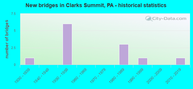
- New bridges - historical statistics
- 11930-1939
- 61950-1959
- 31980-1989
- 11990-1999
- 12010-2019

- Reconstructed bridges - Historical Statistics
- 12000-2009
- 12010-2019


- Bridge Condition - Deck
- 57.1%Good
- 42.9%Satisfactory

- Bridge Condition - Superstructure
- 14.3%Very good
- 57.1%Good
- 14.3%Satisfactory
- 14.3%Fair

- Bridge Condition - Substructure
- 28.6%Good
- 42.9%Satisfactory
- 14.3%Fair
- 14.3%Poor

- Bridge Condition - Channel
- 66.7%Very good
- 33.3%Satisfactory
Find on map >> Show street view
Structure Number: 20373, Location: CLK SMT BO .2 M E SR 4011 (Lat: 41.500069, Lng: -75.710808), Route carried "on" structure: US 6, Year Built: 1986, Status: Open, Structure Length: 3.41m (11.19ft), Average Daily Traffic: 12,498 (year 2022), Truck Traffic: 9%, Average Future Daily Traffic: 18,759 (year 2032), Design Load: HS 20, Features Intersected: NS RAILROAD
Minimum Vertical Clearance: 30+ m (98+ ft), Kilometerpoint: 9.495, Lanes on structure: 2, Base Highway Network: Yes, Owner: State Highway Agency, Approaching Roadway Width: 11.6m (38.1ft), Skew: 6 degrees, Material/Design: Steel, Design/Construction: Stringer/Multi-beam, Number Of Spans In Main Unit: 1, Length of Maximum Span: 31.1m (102.0ft), Curb or Sidewalk Widths: Left: 1.5m (4.9ft), Right: 0.2m (0.7ft), Curb-To-Curb Width: 10.9m (35.8ft), Out-to-Out Width: 14.2m (46.6ft)
Condition: Deck: Satisfactory, Superstructure: Good, Substructure: Satisfactory, Operating Rating: 97.1 metric tons, Method Used To Determine Operating Rating: Load Factor (LF), Inventory Rating: 58.1 metric tons, Method Used To Determine Inventory Rating: Load Factor (LF), Structural Evaluation: Equal to present minimum criteria, Deck Geometry: Meets minimum limits, Underclear: High priority of corrective action, Approach Roadway Alignment: Equal to present desirable criteria, Length Of Structure Improvement: 4.10m (13.45ft), Designated Inspection Frequency: Every 48 months, Inspection Date: July 2020, Deck Structure Type: Concrete Cast-file-Place, Wearing Surface/Protective System: Wearing Surface: Monolithic Concrete, Deck Protection: Epoxy Coated Reinforcing
Find on map >> Show street view
Structure Number: 20758, Location: NEWTON TWP .8M S SR 3003 (Lat: 41.453756, Lng: -75.737081), Route carried "on" structure: State highway , Year Built: 1937, Year Reconstructed: 2009, Status: Open, Structure Length: 0.73m (2.40ft), Average Daily Traffic: 526 (year 2020), Truck Traffic: 7%, Average Future Daily Traffic: 688 (year 2032), Design Load: HS 20, Features Intersected: BRANCH OF GARDNERS CREEK, Facility Carried by Structure: SR 3009
Minimum Vertical Clearance: 30+ m (98+ ft), Kilometerpoint: 4.236, Lanes on structure: 2, Owner: State Highway Agency, Approaching Roadway Width: 6.4m (21.0ft), Skew: 4 degrees, Material/Design: Steel, Design/Construction: Stringer/Multi-beam, Number Of Spans In Main Unit: 1, Length of Maximum Span: 6.7m (22.0ft), Curb or Sidewalk Widths: Left: 0.2m (0.7ft), Right: 0.2m (0.7ft), Curb-To-Curb Width: 6.7m (22.0ft), Out-to-Out Width: 7.6m (24.9ft)
Condition: Deck: Good, Superstructure: Good, Substructure: Satisfactory, Channel: Satisfactory, Inventory Rating: 71.7 metric tons, Method Used To Determine Inventory Rating: Load Factor (LF), Structural Evaluation: Equal to present minimum criteria, Deck Geometry: Meets minimum limits, Waterway Adequacy: Equal to present desirable criteria, Approach Roadway Alignment: Equal to present minimum criteria, Length Of Structure Improvement: 0.70m (2.30ft), Designated Inspection Frequency: Every 24 months, Inspection Date: August 2020, Bridge Improvement Cost: $19,000, Roadway Improvement Cost: $124,000, Total Project Cost: $252,000, Deck Structure Type: Concrete Cast-file-Place, Wearing Surface/Protective System: Wearing Surface: Bituminous, Deck Protection: Epoxy Coated Reinforcing
Find on map >> Show street view
Structure Number: 20831, Location: CLARKS SUMMIT BO JCT TR 6 (Lat: 41.494836, Lng: -75.705969), Route carried "on" structure: State highway , Year Built: 1996, Status: Open, Structure Length: 1.49m (4.89ft), Average Daily Traffic: 5,380 (year 2020), Truck Traffic: 6%, Average Future Daily Traffic: 8,000 (year 2032), Design Load: H 20, Features Intersected: N.S. RR, Facility Carried by Structure: SR4024 WINOLA ROAD
Minimum Vertical Clearance: 30+ m (98+ ft), Kilometerpoint: 1.540, Lanes on structure: 3, Owner: State Highway Agency, Approaching Roadway Width: 11.3m (37.1ft), Material/Design: Prestressed concrete, Design/Construction: Box Beam or Girders - Single/Spread, Number Of Spans In Main Unit: 1, Length of Maximum Span: 14.3m (46.9ft), Curb or Sidewalk Widths: Left: 1.5m (4.9ft), Right: 1.5m (4.9ft), Curb-To-Curb Width: 11.3m (37.1ft), Out-to-Out Width: 14.9m (48.9ft)
Condition: Deck: Good, Superstructure: Good, Substructure: Good, Operating Rating: 62.6 metric tons, Method Used To Determine Operating Rating: Load Factor (LF), Inventory Rating: 37.2 metric tons, Method Used To Determine Inventory Rating: Load Factor (LF), Structural Evaluation: Better than present minimum criteria, Deck Geometry: High priority of replacement, Underclear: High priority of corrective action, Approach Roadway Alignment: Equal to present desirable criteria, Length Of Structure Improvement: 2.19m (7.19ft), Designated Inspection Frequency: Every 48 months, Inspection Date: August 2020, Deck Structure Type: Concrete Cast-file-Place, Wearing Surface/Protective System: Wearing Surface: Monolithic Concrete, Deck Protection: Epoxy Coated Reinforcing
Find on map >> Show street view
Structure Number: 20832, Location: CLARKS SUMMIT .5M S TR 6 (Lat: 41.490883, Lng: -75.702347), Route carried "on" structure: State highway , Year Built: 1984, Status: Open, Structure Length: 7.96m (26.12ft), Average Daily Traffic: 6,383 (year 2020), Truck Traffic: 3%, Average Future Daily Traffic: 11,655 (year 2032), Design Load: HS 20, Features Intersected: N.S. RR, Facility Carried by Structure: SR 4026 WEST GROVE
Minimum Vertical Clearance: 30+ m (98+ ft), Kilometerpoint: 0.822, Lanes on structure: 2, Owner: State Highway Agency, Approaching Roadway Width: 9.8m (32.2ft), Material/Design: Prestressed concrete, Design/Construction: Box Beam or Girders - Single/Spread, Number Of Spans In Main Unit: 3, Length of Maximum Span: 26.2m (86.0ft), Curb or Sidewalk Widths: Left: 1.5m (4.9ft), Right: 1.5m (4.9ft), Curb-To-Curb Width: 8.5m (27.9ft), Out-to-Out Width: 13.3m (43.6ft)
Condition: Deck: Satisfactory, Superstructure: Satisfactory, Substructure: Fair, Operating Rating: 49.9 metric tons, Method Used To Determine Operating Rating: Load Factor (LF), Inventory Rating: 29.9 metric tons, Method Used To Determine Inventory Rating: Load Factor (LF), Structural Evaluation: Somewhat better than minimum adequacy, Deck Geometry: Meets minimum limits, Underclear: High priority of corrective action, Approach Roadway Alignment: Equal to present desirable criteria, Length Of Structure Improvement: 8.90m (29.20ft), Designated Inspection Frequency: Every 24 months, Inspection Date: August 2020, Deck Structure Type: Concrete Cast-file-Place, Wearing Surface/Protective System: Wearing Surface: Monolithic Concrete, Deck Protection: Epoxy Coated Reinforcing
Find on map >> Show street view
Structure Number: 20925, Location: 1000 FT SW OF US 6 (Lat: 41.489103, Lng: -75.700314), Route carried "on" structure: City street , Year Built: 1987, Status: Open, Structure Length: 12.28m (40.29ft), Average Daily Traffic: 1,400 (year 2012), Truck Traffic: 1%, Average Future Daily Traffic: 1,875 (year 2032), Features Intersected: D&H RAILROAD, Facility Carried by Structure: KNAPP RD
Minimum Vertical Clearance: 30+ m (98+ ft), Kilometerpoint: 0.000, Lanes on structure: 2, Owner: Town or Township Highway Agency, Approaching Roadway Width: 8.8m (28.9ft), Material/Design: Prestressed concrete, Design/Construction: Stringer/Multi-beam, Number Of Spans In Main Unit: 4, Length of Maximum Span: 30.5m (100.1ft), Curb or Sidewalk Widths: Left: 0.2m (0.7ft), Right: 1.5m (4.9ft), Curb-To-Curb Width: 8.5m (27.9ft), Out-to-Out Width: 11.1m (36.4ft)
Condition: Deck: Satisfactory, Superstructure: Good, Substructure: Poor, Channel: Very good, Inventory Rating: 39.9 metric tons, Method Used To Determine Inventory Rating: Load Factor (LF), Structural Evaluation: Meets minimum limits, Deck Geometry: Somewhat better than minimum adequacy, Underclear: High priority of corrective action, Waterway Adequacy: Superior to present desirable criteria, Approach Roadway Alignment: Equal to present desirable criteria, Length Of Structure Improvement: 13.20m (43.31ft), Designated Inspection Frequency: Every 24 months, Inspection Date: April 2020, Deck Structure Type: Concrete Cast-file-Place, Wearing Surface/Protective System: Wearing Surface: Monolithic Concrete, Deck Protection: Epoxy Coated Reinforcing
Find on map >> Show street view
Structure Number: 20957, Location: CLARKS SUMMIT BOROUGH (Lat: 41.483333, Lng: -75.691667), Route carried "on" structure: Interstate 476, Year Built: 1955, Year Reconstructed: 2015, Status: Open, Structure Length: 49.59m (162.70ft), Average Daily Traffic: 6,895 (year 2001), Truck Traffic: 19%, Average Future Daily Traffic: 10,187 (year 2030), Design Load: HS 20, Features Intersected: US6&11, SR0407, CP RR
Minimum Vertical Clearance: 30+ m (98+ ft), Kilometerpoint: 0.000, Lanes on structure: 4, Lanes under structure: 7, Base Highway Network: Yes, Toll: On toll road, Owner: State Toll Authority, Approaching Roadway Width: 21.9m (71.9ft), Skew: 30 degrees, Material/Design: Steel continuous, Design/Construction: Girder and Floorbeam System, Number Of Spans In Main Unit: 10, Length of Maximum Span: 51.8m (169.9ft), Curb or Sidewalk Widths: Left: 0.2m (0.7ft), Right: 0.2m (0.7ft), Curb-To-Curb Width: 16.9m (55.4ft), Out-to-Out Width: 18.6m (61.0ft)
Condition: Deck: Good, Superstructure: Fair, Substructure: Satisfactory, Channel: Very good, Operating Rating: 58.1 metric tons, Method Used To Determine Operating Rating: Load Factor (LF), Inventory Rating: 34.5 metric tons, Method Used To Determine Inventory Rating: Load Factor (LF), Structural Evaluation: Somewhat better than minimum adequacy, Deck Geometry: Meets minimum limits, Underclear: High priority of replacement, Waterway Adequacy: Superior to present desirable criteria, Approach Roadway Alignment: Equal to present desirable criteria, Length Of Structure Improvement: 50.30m (165.03ft), Designated Inspection Frequency: Every 24 months, Critical Feature Inspection Frequency: Every 24 months, Inspection Date: July 2019, Critical Feature Inspection Date: July 2019, Bridge Improvement Cost: $1,875,000, Roadway Improvement Cost: $5,521,000, Total Project Cost: $25,308,000, Deck Structure Type: Concrete Precast Panels, Wearing Surface/Protective System: Wearing Surface: Latex Concrete
Find on map >> Show street view
Structure Number: 47771, Location: S ABINGTN TP .4M E TR307 (Lat: 41.475383, Lng: -75.702161), Route carried "on" structure: State highway , Year Built: 2013, Status: Open, Structure Length: 2.56m (8.40ft), Average Daily Traffic: 4,437 (year 2020), Truck Traffic: 3%, Average Future Daily Traffic: 7,294 (year 2033), Design Load: HL 93, Features Intersected: PA TURNPIKE,I-476;NB-736, Facility Carried by Structure: SR 4032
Minimum Vertical Clearance: 30+ m (98+ ft), Kilometerpoint: 3.201, Lanes on structure: 2, Lanes under structure: 4, Owner: State Highway Agency, Approaching Roadway Width: 9.8m (32.2ft), Material/Design: Prestressed concrete, Design/Construction: Stringer/Multi-beam, Number Of Spans In Main Unit: 1, Length of Maximum Span: 25.0m (82.0ft), Curb or Sidewalk Widths: Left: 0.2m (0.7ft), Right: 0.2m (0.7ft), Curb-To-Curb Width: 9.8m (32.2ft), Out-to-Out Width: 10.8m (35.4ft)
Condition: Deck: Good, Superstructure: Very good, Substructure: Good, Operating Rating: 65.4 metric tons, Method Used To Determine Operating Rating: Assigned ratings based on Load and Resistance Factor Design (LRFD) reported by rating factor (RF) using HL93 loadings, Inventory Rating: 34.0 metric tons, Method Used To Determine Inventory Rating: Assigned ratings based on Load and Resistance Factor Design (LRFD) reported by rating factor (RF) using HL93 loadings, Structural Evaluation: Better than present minimum criteria, Deck Geometry: Meets minimum limits, Underclear: Better than present minimum criteria, Approach Roadway Alignment: Better than present minimum criteria, Designated Inspection Frequency: Every 48 months, Inspection Date: January 2021, Deck Structure Type: Concrete Cast-file-Place, Wearing Surface/Protective System: Wearing Surface: Monolithic Concrete, Deck Protection: Epoxy Coated Reinforcing
Find on map >> Show street view
Structure Number: 20954, Location: N. SCRANTON CITY (Lat: 41.471389, Lng: -75.704183), Route carried "under" structure: ServiceOther road , Year Built: 1957, Structure Length: 0. m, Features Intersected: SR0307, LR671, Facility Carried by Structure: PA TPK (I-476)
Minimum Vertical Clearance: 6.22m (20.41ft), Kilometerpoint: 0.000, Lanes on structure: 4, Lanes under structure: 4, Toll: On toll road, Material/Design: Steel, Design/Construction: Girder and Floorbeam System, Length of Maximum Span: 46.6m (152.9ft)
Find on map >> Show street view
Structure Number: 20954, Location: N. SCRANTON CITY (Lat: 41.471389, Lng: -75.704183), Route carried "under" structure: State highway 307, Year Built: 1957, Structure Length: 0. m, Average Daily Traffic: 8,603 (year 2022), Truck Traffic: 3%, Features Intersected: SR0307, LR671, Facility Carried by Structure: PA TPK (I-476)
Minimum Vertical Clearance: 12.41m (40.72ft), Kilometerpoint: 23.846, Lanes on structure: 4, Lanes under structure: 4, Material/Design: Steel, Design/Construction: Girder and Floorbeam System, Length of Maximum Span: 46.6m (152.9ft)
Find on map >> Show street view
Structure Number: 20957, Location: CLARKS SUMMIT BOROUGH (Lat: 41.483333, Lng: -75.691667), Route carried "under" structure: State highway 407, Year Built: 1955, Structure Length: 0. m, Average Daily Traffic: 9,481 (year 2021), Truck Traffic: 2%, Features Intersected: US6&11, SR0407, CP RR, Facility Carried by Structure: PA TPK (I-476)
Minimum Vertical Clearance: 14.33m (47.01ft), Kilometerpoint: 0.000, Lanes on structure: 4, Lanes under structure: 2, Material/Design: Steel continuous, Design/Construction: Girder and Floorbeam System, Length of Maximum Span: 51.8m (169.9ft)
Find on map >> Show street view
Structure Number: 20957, Location: CLARKS SUMMIT BOROUGH (Lat: 41.483333, Lng: -75.691667), Route carried "under" structure: US 6, Year Built: 1955, Structure Length: 0. m, Average Daily Traffic: 13,673 (year 2022), Truck Traffic: 5%, Features Intersected: US6&11, SR0407, CP RR
Minimum Vertical Clearance: 30.18m (99.02ft), Kilometerpoint: 12.036, Lanes on structure: 4, Lanes under structure: 3, Material/Design: Steel continuous, Design/Construction: Girder and Floorbeam System, Length of Maximum Span: 51.8m (169.9ft)
Find on map >> Show street view
Structure Number: 20957, Location: CLARKS SUMMIT BOROUGH (Lat: 41.483333, Lng: -75.691667), Route carried "under" structure: US 6, Year Built: 1955, Structure Length: 0. m, Average Daily Traffic: 12,557 (year 2022), Truck Traffic: 5%, Features Intersected: US6&11, SR0407, CP RR
Minimum Vertical Clearance: 30+ m (98+ ft), Kilometerpoint: 12.028, Lanes on structure: 4, Lanes under structure: 2, Material/Design: Steel continuous, Design/Construction: Girder and Floorbeam System, Length of Maximum Span: 51.8m (169.9ft)