Bridge Statistics for Claremont, North Carolina (NC)
Condition, Traffic, Stress, Structural Evaluation, Project Costs
- National Bridge Inventory (NBI) Statistics
- 21Number of bridges
- 167ft / 50.8mTotal length
- 273,620Total average daily traffic
- 46,050Total average daily truck traffic
- National Bridge Inventory (NBI) Registered Bridges for Claremont
- No street view available for this location
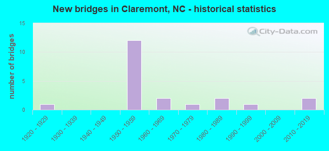
- New bridges - historical statistics
- 11920-1929
- 121950-1959
- 21960-1969
- 11970-1979
- 21980-1989
- 11990-1999
- 22010-2019


- Bridge Condition - Deck
- 9.1%Very good
- 36.4%Good
- 9.1%Satisfactory
- 36.4%Fair
- 9.1%Poor

- Bridge Condition - Superstructure
- 9.1%Very good
- 18.2%Good
- 54.5%Satisfactory
- 18.2%Fair

- Bridge Condition - Substructure
- 9.1%Very good
- 27.3%Good
- 36.4%Satisfactory
- 27.3%Fair

- Bridge Condition - Channel
- 71.4%Good
- 14.3%Satisfactory
- 14.3%Fair

- Bridge Condition - Culverts
- 83.3%Satisfactory
- 16.7%Fair
Find on map >> Show street view
Structure Number: 350002, Location: 25 FT. S. JCT. SR1707 (Lat: 35.735819, Lng: -81.133675), Route carried "on" structure: State highway 1716, Year Built: 1989, Status: Open, Structure Length: 3.84m (12.60ft), Average Daily Traffic: 2,700 (year 2015), Truck Traffic: 6%, Average Future Daily Traffic: 5,400 (year 2040), Design Load: HS 20+Mod, Features Intersected: LYLE CREEK
Minimum Vertical Clearance: 30+ m (98+ ft), Kilometerpoint: 0.000, Lanes on structure: 2, Owner: State Highway Agency, Approaching Roadway Width: 6.7m (22.0ft), Skew: 1 degrees, Material/Design: Prestressed concrete, Design/Construction: Slab, Number Of Spans In Main Unit: 3, Length of Maximum Span: 13.4m (44.0ft), Curb-To-Curb Width: 9.1m (29.9ft), Out-to-Out Width: 10.0m (32.8ft)
Condition: Deck: Good, Superstructure: Good, Substructure: Good, Channel: Good, Operating Rating: 89.8 metric tons, Method Used To Determine Operating Rating: Load Factor (LF), Inventory Rating: 58.0 metric tons, Method Used To Determine Inventory Rating: Load Factor (LF), Structural Evaluation: Better than present minimum criteria, Deck Geometry: Meets minimum limits, Waterway Adequacy: Better than present minimum criteria, Approach Roadway Alignment: Equal to present desirable criteria, Designated Inspection Frequency: Every 24 months, Inspection Date: Febuary 2021, Deck Structure Type: Concrete Precast Panels, Wearing Surface/Protective System: Wearing Surface: Monolithic Concrete, Membrane: Built-up, Deck Protection: Epoxy Coated Reinforcing
Find on map >> Show street view
Structure Number: 350089, Location: 25 FT. E. JCT. SR2413 (Lat: 35.686789, Lng: -81.153592), Route carried "on" structure: State highway 1731, Year Built: 1962, Year Reconstructed: 1995, Status: Open, Structure Length: 2.07m (6.79ft), Average Daily Traffic: 1,600 (year 2015), Truck Traffic: 7%, Average Future Daily Traffic: 3,200 (year 2040), Features Intersected: MCLIN CREEK
Minimum Vertical Clearance: 30+ m (98+ ft), Kilometerpoint: 0.000, Lanes on structure: 2, Owner: State Highway Agency, Approaching Roadway Width: 7.3m (24.0ft), Material/Design: Steel continuous, Design/Construction: Stringer/Multi-beam, Number Of Spans In Main Unit: 2, Number Of Approach Spans: 1, Length of Maximum Span: 7.3m (24.0ft), Curb-To-Curb Width: 7.3m (24.0ft), Out-to-Out Width: 7.6m (24.9ft)
Condition: Deck: Good, Superstructure: Satisfactory, Substructure: Good, Channel: Good, Operating Rating: 84.3 metric tons, Method Used To Determine Operating Rating: Load Factor (LF), Inventory Rating: 49.8 metric tons, Method Used To Determine Inventory Rating: Load Factor (LF), Structural Evaluation: Equal to present minimum criteria, Deck Geometry: Meets minimum limits, Waterway Adequacy: Better than present minimum criteria, Approach Roadway Alignment: Equal to present desirable criteria, Designated Inspection Frequency: Every 24 months, Inspection Date: Febuary 2021, Deck Structure Type: Corrugated Steel, Wearing Surface/Protective System: Wearing Surface: Bituminous
Find on map >> Show street view
Structure Number: 35009, Location: 0.3 MI. E. JCT. SR1996 (Lat: 35.684953, Lng: -81.128389), Route carried "on" structure: State highway 1727, Year Built: 2013, Status: Open, Structure Length: 3.04m (9.97ft), Average Daily Traffic: 2,900 (year 2019), Truck Traffic: 7%, Average Future Daily Traffic: 5,800 (year 2040), Design Load: HL 93, Features Intersected: HAGAN FORK CREEK
Minimum Vertical Clearance: 30+ m (98+ ft), Kilometerpoint: 0.000, Lanes on structure: 2, Owner: State Highway Agency, Approaching Roadway Width: 8.8m (28.9ft), Skew: 3 degrees, Material/Design: Prestressed concrete, Design/Construction: Box Beam or Girders - Multiple, Number Of Spans In Main Unit: 1, Length of Maximum Span: 29.2m (95.8ft), Curb-To-Curb Width: 9.0m (29.5ft), Out-to-Out Width: 10.0m (32.8ft)
Condition: Deck: Very good, Superstructure: Very good, Substructure: Very good, Channel: Good, Operating Rating: 62.5 metric tons, Method Used To Determine Operating Rating: Load and Resistance Factor (LRFR), Inventory Rating: 48.0 metric tons, Method Used To Determine Inventory Rating: Load and Resistance Factor (LRFR), Structural Evaluation: Equal to present desirable criteria, Deck Geometry: Meets minimum limits, Waterway Adequacy: Better than present minimum criteria, Approach Roadway Alignment: Equal to present desirable criteria, Designated Inspection Frequency: Every 24 months, Inspection Date: Febuary 2021, Deck Structure Type: Concrete Precast Panels, Wearing Surface/Protective System: Wearing Surface: Bituminous
Find on map >> Show street view
Structure Number: 350092, Location: 0.15 MI. S. JCT. SR2436 (Lat: 35.697628, Lng: -81.145689), Route carried "on" structure: State highway 1722, Year Built: 1951, Status: Open, Structure Length: 2.46m (8.07ft), Average Daily Traffic: 2,700 (year 2015), Truck Traffic: 7%, Average Future Daily Traffic: 5,400 (year 2040), Features Intersected: MCLIN CREEK
Minimum Vertical Clearance: 30+ m (98+ ft), Kilometerpoint: 0.000, Lanes on structure: 2, Owner: State Highway Agency, Approaching Roadway Width: 7.0m (23.0ft), Material/Design: Steel, Design/Construction: Stringer/Multi-beam, Number Of Spans In Main Unit: 2, Length of Maximum Span: 12.1m (39.7ft), Curb-To-Curb Width: 8.5m (27.9ft), Out-to-Out Width: 8.8m (28.9ft)
Condition: Deck: Satisfactory, Superstructure: Satisfactory, Substructure: Satisfactory, Channel: Good, Operating Rating: 58.0 metric tons, Method Used To Determine Operating Rating: Load Factor (LF), Inventory Rating: 34.4 metric tons, Method Used To Determine Inventory Rating: Load Factor (LF), Structural Evaluation: Equal to present minimum criteria, Deck Geometry: Meets minimum limits, Waterway Adequacy: Better than present minimum criteria, Approach Roadway Alignment: Equal to present desirable criteria, Designated Inspection Frequency: Every 24 months, Inspection Date: Febuary 2021, Deck Structure Type: Corrugated Steel, Wearing Surface/Protective System: Wearing Surface: Bituminous
Find on map >> Show street view
Structure Number: 350093, Location: 0.1 MI. S. JCT. US70 (Lat: 35.713633, Lng: -81.144797), Route carried "on" structure: State highway 1716, Year Built: 1969, Status: Open, Structure Length: 4.02m (13.19ft), Average Daily Traffic: 3,300 (year 2019), Truck Traffic: 7%, Average Future Daily Traffic: 6,600 (year 2040), Design Load: HS 15, Features Intersected: SOUTHERN RAILROAD
Minimum Vertical Clearance: 30+ m (98+ ft), Kilometerpoint: 0.000, Lanes on structure: 2, Owner: State Highway Agency, Approaching Roadway Width: 10.6m (34.8ft), Material/Design: Steel, Design/Construction: Stringer/Multi-beam, Number Of Spans In Main Unit: 3, Length of Maximum Span: 14.6m (47.9ft), Curb or Sidewalk Widths: Left: 0.4m (1.3ft), Right: 1.5m (4.9ft), Curb-To-Curb Width: 8.5m (27.9ft), Out-to-Out Width: 11.3m (37.1ft)
Condition: Deck: Good, Superstructure: Satisfactory, Substructure: Satisfactory, Operating Rating: 49.8 metric tons, Method Used To Determine Operating Rating: Load Factor (LF), Inventory Rating: 29.9 metric tons, Method Used To Determine Inventory Rating: Load Factor (LF), Structural Evaluation: Equal to present minimum criteria, Deck Geometry: Meets minimum limits, Underclear: High priority of corrective action, Approach Roadway Alignment: Equal to present desirable criteria, Designated Inspection Frequency: Every 24 months, Inspection Date: Febuary 2021, Deck Structure Type: Concrete Cast-file-Place, Wearing Surface/Protective System: Wearing Surface: Monolithic Concrete
Find on map >> Show street view
Structure Number: 350109, Location: 0.4 MI. W. JCT. SR1808 (Lat: 35.676994, Lng: -81.134350), Route carried "on" structure: State highway 10, Year Built: 1929, Status: Open, Structure Length: 1.28m (4.20ft), Average Daily Traffic: 4,200 (year 2019), Truck Traffic: 8%, Average Future Daily Traffic: 8,400 (year 2040), Design Load: H 15, Features Intersected: HAGAN FORK
Minimum Vertical Clearance: 30+ m (98+ ft), Kilometerpoint: 0.000, Lanes on structure: 2, Owner: State Highway Agency, Approaching Roadway Width: 6.7m (22.0ft), Material/Design: Concrete continuous, Design/Construction: Culvert, Number Of Spans In Main Unit: 4, Length of Maximum Span: 3.0m (9.8ft)
Condition: Channel: Good, Culverts: Fair, Operating Rating: 62.5 metric tons, Method Used To Determine Operating Rating: Load Factor (LF), Inventory Rating: 38.1 metric tons, Method Used To Determine Inventory Rating: Load Factor (LF), Structural Evaluation: Somewhat better than minimum adequacy, Waterway Adequacy: Better than present minimum criteria, Approach Roadway Alignment: Equal to present desirable criteria, Designated Inspection Frequency: Every 24 months, Inspection Date: Febuary 2021
Find on map >> Show street view
Structure Number: 350121, Location: 0.9 MI. N. JCT. SR1807 (Lat: 35.669522, Lng: -81.132164), Route carried "on" structure: State highway 1808, Year Built: 1988, Status: Open, Structure Length: 0.79m (2.59ft), Average Daily Traffic: 450 (year 2003), Truck Traffic: 6%, Average Future Daily Traffic: 900 (year 2040), Design Load: HS 20+Mod, Features Intersected: UT TO HAGAN FORK CREEK
Minimum Vertical Clearance: 30+ m (98+ ft), Kilometerpoint: 0.000, Lanes on structure: 2, Owner: State Highway Agency, Approaching Roadway Width: 5.7m (18.7ft), Skew: 1 degrees, Material/Design: Steel, Design/Construction: Culvert, Number Of Spans In Main Unit: 2, Length of Maximum Span: 3.6m (11.8ft)
Condition: Channel: Good, Culverts: Satisfactory, Operating Rating: 89.8 metric tons, Method Used To Determine Operating Rating: Load and Resistance Factor (LRFR), Inventory Rating: 89.8 metric tons, Method Used To Determine Inventory Rating: Load and Resistance Factor (LRFR), Structural Evaluation: Equal to present minimum criteria, Waterway Adequacy: Better than present minimum criteria, Approach Roadway Alignment: Equal to present desirable criteria, Designated Inspection Frequency: Every 24 months, Inspection Date: March 2021
Find on map >> Show street view
Structure Number: 350174, Location: 0.1 MI. W. JCT. SR1715 (Lat: 35.722503, Lng: -81.159511), Route carried "on" structure: Interstate 40, Year Built: 1959, Status: Open, Structure Length: 0.82m (2.69ft), Average Daily Traffic: 47,500 (year 2019), Truck Traffic: 16%, Average Future Daily Traffic: 95,000 (year 2040), Design Load: HS 20+Mod, Features Intersected: MULL CREEK
Minimum Vertical Clearance: 30+ m (98+ ft), Kilometerpoint: 40.965, Lanes on structure: 6, Base Highway Network: Yes (Inventory Route: 1, Subroute: 40), Owner: State Highway Agency, Approaching Roadway Width: 32.9m (107.9ft), Skew: 24 degrees, Material/Design: Concrete continuous, Design/Construction: Culvert, Number Of Spans In Main Unit: 2, Length of Maximum Span: 3.0m (9.8ft)
Condition: Channel: Good, Culverts: Satisfactory, Operating Rating: 41.7 metric tons, Method Used To Determine Operating Rating: Field evaluation and documented engineering judgment, Inventory Rating: 32.6 metric tons, Method Used To Determine Inventory Rating: Field evaluation and documented engineering judgment, Structural Evaluation: Equal to present minimum criteria, Waterway Adequacy: Better than present minimum criteria, Approach Roadway Alignment: Equal to present desirable criteria, Designated Inspection Frequency: Every 24 months, Underwater Inspection Frequency: Every 60 months, Inspection Date: March 2021, Underwater Inspection Date: April 2019
Find on map >> Show street view
Structure Number: 350175, Location: 0.6 MI. N. JCT. US70 (Lat: 35.722814, Lng: -81.157525), Route carried "on" structure: State highway 1715, Year Built: 1957, Status: Open, Structure Length: 6.61m (21.69ft), Average Daily Traffic: 14,000 (year 2019), Truck Traffic: 7%, Average Future Daily Traffic: 28,000 (year 2040), Design Load: HS 15, Features Intersected: I40
Minimum Vertical Clearance: 30+ m (98+ ft), Kilometerpoint: 0.000, Lanes on structure: 2, Lanes under structure: 4, Owner: State Highway Agency, Approaching Roadway Width: 8.8m (28.9ft), Material/Design: Concrete, Design/Construction: Tee Beam, Number Of Spans In Main Unit: 4, Length of Maximum Span: 17.3m (56.8ft), Curb or Sidewalk Widths: Left: 0.4m (1.3ft), Right: 0.4m (1.3ft), Curb-To-Curb Width: 8.5m (27.9ft), Out-to-Out Width: 10.1m (33.1ft)
Condition: Deck: Fair, Superstructure: Fair, Substructure: Fair, Operating Rating: 64.4 metric tons, Method Used To Determine Operating Rating: Load Factor (LF), Inventory Rating: 38.1 metric tons, Method Used To Determine Inventory Rating: Load Factor (LF), Structural Evaluation: Somewhat better than minimum adequacy, Deck Geometry: Meets minimum limits, Underclear: Equal to present minimum criteria, Approach Roadway Alignment: Equal to present desirable criteria, Designated Inspection Frequency: Every 24 months, Inspection Date: April 2021, Deck Structure Type: Concrete Cast-file-Place, Wearing Surface/Protective System: Wearing Surface: Monolithic Concrete
Find on map >> Show street view
Structure Number: 350176, Location: 0.6 MI. N. JCT. US70 (Lat: 35.724925, Lng: -81.143989), Route carried "on" structure: State highway 1716, Year Built: 1957, Status: Open, Structure Length: 7.13m (23.39ft), Average Daily Traffic: 3,000 (year 2019), Truck Traffic: 7%, Average Future Daily Traffic: 6,000 (year 2040), Design Load: HS 15, Features Intersected: I40
Minimum Vertical Clearance: 30+ m (98+ ft), Kilometerpoint: 0.000, Lanes on structure: 2, Lanes under structure: 4, Owner: State Highway Agency, Approaching Roadway Width: 7.0m (23.0ft), Skew: 2 degrees, Material/Design: Concrete, Design/Construction: Tee Beam, Number Of Spans In Main Unit: 4, Length of Maximum Span: 17.6m (57.7ft), Curb or Sidewalk Widths: Left: 0.9m (3.0ft), Right: 0.9m (3.0ft), Curb-To-Curb Width: 8.5m (27.9ft), Out-to-Out Width: 10.9m (35.8ft)
Condition: Deck: Fair, Superstructure: Satisfactory, Substructure: Satisfactory, Operating Rating: 71.6 metric tons, Method Used To Determine Operating Rating: Load Factor (LF), Inventory Rating: 42.6 metric tons, Method Used To Determine Inventory Rating: Load Factor (LF), Structural Evaluation: Equal to present minimum criteria, Deck Geometry: Meets minimum limits, Underclear: High priority of corrective action, Approach Roadway Alignment: Equal to present minimum criteria, Designated Inspection Frequency: Every 24 months, Inspection Date: April 2021, Deck Structure Type: Concrete Cast-file-Place, Wearing Surface/Protective System: Wearing Surface: Monolithic Concrete
Find on map >> Show street view
Structure Number: 350177, Location: 2.0 MI. E. JCT. SR1716 (Lat: 35.728203, Lng: -81.122981), Route carried "on" structure: Interstate 40, Year Built: 1957, Status: Open, Structure Length: 5.48m (17.98ft), Average Daily Traffic: 21,000 (year 2019), Truck Traffic: 23%, Average Future Daily Traffic: 42,000 (year 2040), Design Load: HS 20+Mod, Features Intersected: LYLE CREEK
Minimum Vertical Clearance: 30+ m (98+ ft), Kilometerpoint: 41.605, Lanes on structure: 2, Base Highway Network: Yes (Inventory Route: 1, Subroute: 40), Owner: State Highway Agency, Approaching Roadway Width: 8.2m (26.9ft), Skew: 12 degrees, Material/Design: Concrete, Design/Construction: Tee Beam, Number Of Spans In Main Unit: 4, Length of Maximum Span: 13.4m (44.0ft), Curb-To-Curb Width: 8.6m (28.2ft), Out-to-Out Width: 10.1m (33.1ft)
Condition: Deck: Poor, Superstructure: Satisfactory, Substructure: Satisfactory, Channel: Fair, Operating Rating: 81.6 metric tons, Method Used To Determine Operating Rating: Load Factor (LF), Inventory Rating: 48.9 metric tons, Method Used To Determine Inventory Rating: Load Factor (LF), Structural Evaluation: Equal to present minimum criteria, Deck Geometry: High priority of replacement, Waterway Adequacy: Better than present minimum criteria, Approach Roadway Alignment: Equal to present desirable criteria, Designated Inspection Frequency: Every 24 months, Inspection Date: March 2021, Deck Structure Type: Concrete Cast-file-Place, Wearing Surface/Protective System: Wearing Surface: Monolithic Concrete
Find on map >> Show street view
Structure Number: 350178, Location: 1.2 MI. E. JCT. SR1716 (Lat: 35.728356, Lng: -81.123058), Route carried "on" structure: Interstate 40, Year Built: 1957, Status: Open, Structure Length: 5.48m (17.98ft), Average Daily Traffic: 21,000 (year 2019), Truck Traffic: 23%, Average Future Daily Traffic: 42,000 (year 2040), Design Load: HS 20+Mod, Features Intersected: LYLE CREEK
Minimum Vertical Clearance: 30+ m (98+ ft), Kilometerpoint: 41.605, Lanes on structure: 2, Base Highway Network: Yes (Inventory Route: 1, Subroute: 40), Owner: State Highway Agency, Approaching Roadway Width: 7.9m (25.9ft), Skew: 12 degrees, Material/Design: Concrete, Design/Construction: Tee Beam, Number Of Spans In Main Unit: 4, Length of Maximum Span: 13.1m (43.0ft), Curb-To-Curb Width: 8.6m (28.2ft), Out-to-Out Width: 10.1m (33.1ft)
Condition: Deck: Fair, Superstructure: Satisfactory, Substructure: Fair, Channel: Fair, Operating Rating: 80.7 metric tons, Method Used To Determine Operating Rating: Load Factor (LF), Inventory Rating: 48.0 metric tons, Method Used To Determine Inventory Rating: Load Factor (LF), Structural Evaluation: Somewhat better than minimum adequacy, Deck Geometry: High priority of replacement, Waterway Adequacy: Better than present minimum criteria, Approach Roadway Alignment: Equal to present desirable criteria, Designated Inspection Frequency: Every 24 months, Inspection Date: March 2021, Deck Structure Type: Concrete Cast-file-Place, Wearing Surface/Protective System: Wearing Surface: Monolithic Concrete
Find on map >> Show street view
Structure Number: 350229, Location: 0.4 MI. E. JCT. SR1807 (Lat: 35.663642, Lng: -81.130317), Route carried "on" structure: State highway 1809, Year Built: 2013, Status: Open, Structure Length: 2.83m (9.28ft), Average Daily Traffic: 280 (year 2015), Truck Traffic: 6%, Average Future Daily Traffic: 560 (year 2040), Design Load: HL 93, Features Intersected: UT TO HAGAN FORK
Minimum Vertical Clearance: 30+ m (98+ ft), Kilometerpoint: 0.000, Lanes on structure: 2, Owner: State Highway Agency, Approaching Roadway Width: 7.3m (24.0ft), Skew: 3 degrees, Material/Design: Prestressed concrete, Design/Construction: Slab, Number Of Spans In Main Unit: 2, Length of Maximum Span: 17.6m (57.7ft), Curb-To-Curb Width: 7.4m (24.3ft), Out-to-Out Width: 8.2m (26.9ft)
Condition: Deck: Good, Superstructure: Good, Substructure: Good, Channel: Good, Operating Rating: 57.1 metric tons, Method Used To Determine Operating Rating: Load and Resistance Factor (LRFR), Inventory Rating: 43.5 metric tons, Method Used To Determine Inventory Rating: Load and Resistance Factor (LRFR), Structural Evaluation: Better than present minimum criteria, Deck Geometry: Somewhat better than minimum adequacy, Waterway Adequacy: Better than present minimum criteria, Approach Roadway Alignment: Equal to present desirable criteria, Designated Inspection Frequency: Every 24 months, Inspection Date: March 2021, Deck Structure Type: Concrete Precast Panels, Wearing Surface/Protective System: Wearing Surface: Bituminous, Deck Protection: Epoxy Coated Reinforcing
Find on map >> Show street view
Structure Number: 350255, Location: 0.1 MI. W. JCT. SR1802 (Lat: 35.654956, Lng: -81.145103), Route carried "on" structure: State highway 1806, Year Built: 1971, Status: Posted for load, Structure Length: 2.77m (9.09ft), Average Daily Traffic: 370 (year 2015), Truck Traffic: 6%, Average Future Daily Traffic: 740 (year 2040), Features Intersected: HAGAN FORK CREEK
Minimum Vertical Clearance: 30+ m (98+ ft), Kilometerpoint: 0.000, Lanes on structure: 2, Owner: State Highway Agency, Approaching Roadway Width: 5.4m (17.7ft), Material/Design: Prestressed concrete, Design/Construction: Channel Beam, Number Of Spans In Main Unit: 3, Length of Maximum Span: 9.1m (29.9ft), Curb or Sidewalk Widths: Left: 0.1m (0.3ft), Right: 0.1m (0.3ft), Curb-To-Curb Width: 7.3m (24.0ft), Out-to-Out Width: 7.7m (25.3ft)
Condition: Deck: Fair, Superstructure: Fair, Substructure: Fair, Channel: Satisfactory, Operating Rating: 26.3 metric tons, Method Used To Determine Operating Rating: Load Factor (LF), Inventory Rating: 9.0 metric tons, Method Used To Determine Inventory Rating: Load Factor (LF), Structural Evaluation: High priority of corrective action, Deck Geometry: Somewhat better than minimum adequacy, Waterway Adequacy: Better than present minimum criteria, Approach Roadway Alignment: Equal to present desirable criteria, Bridge Posting: Required (Relationship of Operating Rating to Maximum Legal Load: 30.0 - 39.9% below), Designated Inspection Frequency: Every 24 months, Inspection Date: March 2021, Deck Structure Type: Concrete Cast-file-Place, Wearing Surface/Protective System: Wearing Surface: Bituminous
Find on map >> Show street view
Structure Number: 350309, Location: 0.12 MI. W. JCT. SR1730 (Lat: 35.698964, Lng: -81.160019), Route carried "on" structure: State highway 2436, Year Built: 1990, Status: Open, Structure Length: 0.64m (2.10ft), Average Daily Traffic: 20 (year 1990), Average Future Daily Traffic: 40 (year 2040), Design Load: HS 20+Mod, Features Intersected: LONG CREEK
Minimum Vertical Clearance: 30+ m (98+ ft), Kilometerpoint: 0.000, Lanes on structure: 2, Owner: State Highway Agency, Approaching Roadway Width: 7.3m (24.0ft), Skew: 1 degrees, Material/Design: Steel, Design/Construction: Culvert, Number Of Spans In Main Unit: 2, Length of Maximum Span: 2.4m (7.9ft)
Condition: Channel: Satisfactory, Culverts: Satisfactory, Operating Rating: 89.8 metric tons, Method Used To Determine Operating Rating: Load and Resistance Factor (LRFR), Inventory Rating: 89.8 metric tons, Method Used To Determine Inventory Rating: Load and Resistance Factor (LRFR), Structural Evaluation: Equal to present minimum criteria, Waterway Adequacy: Better than present minimum criteria, Approach Roadway Alignment: Equal to present desirable criteria, Designated Inspection Frequency: Every 24 months, Inspection Date: Febuary 2021
Find on map >> Show street view
Structure Number: 350313, Location: 1.6 MI. E. JCT. SR1716 (Lat: 35.728672, Lng: -81.120131), Route carried "on" structure: Interstate 40, Year Built: 1957, Status: Open, Structure Length: 0.85m (2.79ft), Average Daily Traffic: 42,000 (year 2019), Truck Traffic: 23%, Average Future Daily Traffic: 84,000 (year 2040), Design Load: HS 15, Features Intersected: UT TO LYLE CREEK
Minimum Vertical Clearance: 30+ m (98+ ft), Kilometerpoint: 41.666, Lanes on structure: 4, Base Highway Network: Yes (Inventory Route: 1, Subroute: 40), Owner: State Highway Agency, Approaching Roadway Width: 23.1m (75.8ft), Skew: 22 degrees, Material/Design: Concrete continuous, Design/Construction: Culvert, Number Of Spans In Main Unit: 3, Length of Maximum Span: 2.4m (7.9ft)
Condition: Channel: Good, Culverts: Satisfactory, Operating Rating: 37.1 metric tons, Method Used To Determine Operating Rating: Load and Resistance Factor (LRFR), Inventory Rating: 29.0 metric tons, Method Used To Determine Inventory Rating: Load and Resistance Factor (LRFR), Structural Evaluation: Equal to present minimum criteria, Waterway Adequacy: Better than present minimum criteria, Approach Roadway Alignment: Equal to present desirable criteria, Designated Inspection Frequency: Every 24 months, Underwater Inspection Frequency: Every 60 months, Inspection Date: March 2021, Underwater Inspection Date: April 2019
Find on map >> Show street view
Structure Number: 350314, Location: 0.1 MI. N. JCT. I40 (Lat: 35.724000, Lng: -81.157858), Route carried "on" structure: State highway 1715, Year Built: 1957, Status: Open, Structure Length: 0.67m (2.20ft), Average Daily Traffic: 4,600 (year 2015), Truck Traffic: 7%, Average Future Daily Traffic: 9,200 (year 2040), Design Load: HS 15, Features Intersected: MULL CREEK
Minimum Vertical Clearance: 30+ m (98+ ft), Kilometerpoint: 0.000, Lanes on structure: 2, Owner: State Highway Agency, Approaching Roadway Width: 7.3m (24.0ft), Skew: 1 degrees, Material/Design: Concrete continuous, Design/Construction: Culvert, Number Of Spans In Main Unit: 2, Length of Maximum Span: 3.0m (9.8ft)
Condition: Channel: Good, Culverts: Satisfactory, Operating Rating: 61.6 metric tons, Method Used To Determine Operating Rating: Load and Resistance Factor (LRFR), Inventory Rating: 47.1 metric tons, Method Used To Determine Inventory Rating: Load and Resistance Factor (LRFR), Structural Evaluation: Equal to present minimum criteria, Waterway Adequacy: Better than present minimum criteria, Approach Roadway Alignment: Equal to present desirable criteria, Designated Inspection Frequency: Every 24 months, Underwater Inspection Frequency: Every 60 months, Inspection Date: March 2021, Underwater Inspection Date: April 2019
Find on map >> Show street view
Structure Number: 350175, Location: 0.6 MI. N. JCT. US70 (Lat: 35.722814, Lng: -81.157525), Route carried "under" structure: Interstate 40, Year Built: 1957, Structure Length: 0. m, Average Daily Traffic: 25,500 (year 2017), Truck Traffic: 16%, Features Intersected: SR1715
Minimum Vertical Clearance: 5.96m (19.55ft), Kilometerpoint: 41.002, Lanes on structure: 2, Lanes under structure: 2, Material/Design: Concrete, Design/Construction: Tee Beam, Length of Maximum Span: 17.3m (56.8ft)
Find on map >> Show street view
Structure Number: 350175, Location: 0.6 MI. N. JCT. US70 (Lat: 35.722814, Lng: -81.157525), Route carried "under" structure: Interstate 40, Year Built: 1957, Structure Length: 0. m, Average Daily Traffic: 25,500 (year 2017), Truck Traffic: 16%, Features Intersected: SR1715
Minimum Vertical Clearance: 5.19m (17.03ft), Kilometerpoint: 41.002, Lanes on structure: 2, Lanes under structure: 2, Material/Design: Concrete, Design/Construction: Tee Beam, Length of Maximum Span: 17.3m (56.8ft)
Find on map >> Show street view
Structure Number: 350176, Location: 0.6 MI. N. JCT. US70 (Lat: 35.724925, Lng: -81.143989), Route carried "under" structure: Interstate 40, Year Built: 1957, Structure Length: 0. m, Average Daily Traffic: 25,500 (year 2017), Truck Traffic: 16%, Features Intersected: SR1716
Minimum Vertical Clearance: 4.67m (15.32ft), Kilometerpoint: 41.239, Lanes on structure: 2, Lanes under structure: 2, Material/Design: Concrete, Design/Construction: Tee Beam, Length of Maximum Span: 17.6m (57.7ft)
Find on map >> Show street view
Structure Number: 350176, Location: 0.6 MI. N. JCT. US70 (Lat: 35.724925, Lng: -81.143989), Route carried "under" structure: Interstate 40, Year Built: 1957, Structure Length: 0. m, Average Daily Traffic: 25,500 (year 2017), Truck Traffic: 16%, Features Intersected: SR1716
Minimum Vertical Clearance: 4.73m (15.52ft), Kilometerpoint: 41.239, Lanes on structure: 2, Lanes under structure: 2, Material/Design: Concrete, Design/Construction: Tee Beam, Length of Maximum Span: 17.6m (57.7ft)