Bridge Statistics for Christopher, Illinois (IL)
Condition, Traffic, Stress, Structural Evaluation, Project Costs
- National Bridge Inventory (NBI) Statistics
- 12Number of bridges
- 43ft / 13.3mTotal length
- 21,225Total average daily traffic
- 1,333Total average daily truck traffic
- National Bridge Inventory (NBI) Registered Bridges for Christopher
- No street view available for this location
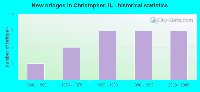
- New bridges - historical statistics
- 11960-1969
- 21970-1979
- 31980-1989
- 31990-1999
- 32000-2009


- Bridge Condition - Deck
- 37.5%Very good
- 50.0%Good
- 12.5%Satisfactory

- Bridge Condition - Superstructure
- 37.5%Very good
- 50.0%Good
- 12.5%Satisfactory

- Bridge Condition - Substructure
- 37.5%Very good
- 62.5%Good

- Bridge Condition - Channel
- 54.5%Very good
- 27.3%Good
- 18.2%Satisfactory

- Bridge Condition - Culverts
- 66.7%Good
- 33.3%Satisfactory
Find on map >> Show street view
Structure Number: 282004, Location: 1.2 MI S CHRISTOPHER (Lat: 37.947967, Lng: -89.053956), Route carried "on" structure: State highway 148, Year Built: 1967, Status: Open, Structure Length: 0.76m (2.49ft), Average Daily Traffic: 3,950 (year 2021), Truck Traffic: 8%, Average Future Daily Traffic: 5,136 (year 2032), Design Load: HS 20, Features Intersected: STREAM S CHRISTOPHER
Minimum Vertical Clearance: 30+ m (98+ ft), Kilometerpoint: 39.975, Lanes on structure: 2, Base Highway Network: Yes, Owner: State Highway Agency, Approaching Roadway Width: 9.8m (32.2ft), Skew: 1 degrees, Material/Design: Concrete continuous, Design/Construction: Culvert, Number Of Spans In Main Unit: 2, Length of Maximum Span: 3.4m (11.2ft)
Condition: Channel: Satisfactory, Culverts: Satisfactory, Operating Rating: 89.1 metric tons, Method Used To Determine Operating Rating: Load Factor (LF) rating reported by rating factor (RF) method using MS18 loading, Inventory Rating: 89.1 metric tons, Method Used To Determine Inventory Rating: Load Factor (LF) rating reported by rating factor (RF) method using MS18 loading, Structural Evaluation: Equal to present minimum criteria, Waterway Adequacy: Equal to present desirable criteria, Approach Roadway Alignment: Equal to present desirable criteria, Designated Inspection Frequency: Every 24 months, Inspection Date: January 2021
Find on map >> Show street view
Structure Number: 282014, Location: E OF CHRISTOPHER ECL (Lat: 37.979361, Lng: -89.046142), Route carried "on" structure: State highway 14, Year Built: 2001, Status: Open, Structure Length: 1.01m (3.31ft), Average Daily Traffic: 5,150 (year 2021), Truck Traffic: 6%, Average Future Daily Traffic: 5,877 (year 2032), Design Load: HS 20, Features Intersected: UNNAMED ANDY CR TRIB
Minimum Vertical Clearance: 30+ m (98+ ft), Kilometerpoint: 16.624, Lanes on structure: 2, Base Highway Network: Yes, Owner: State Highway Agency, Approaching Roadway Width: 9.4m (30.8ft), Skew: 4 degrees, Material/Design: Concrete continuous, Design/Construction: Culvert, Number Of Spans In Main Unit: 2, Length of Maximum Span: 3.3m (10.8ft)
Condition: Channel: Good, Culverts: Good, Operating Rating: 59.9 metric tons, Method Used To Determine Operating Rating: Load Factor (LF) rating reported by rating factor (RF) method using MS18 loading, Inventory Rating: 36.0 metric tons, Method Used To Determine Inventory Rating: Load Factor (LF) rating reported by rating factor (RF) method using MS18 loading, Structural Evaluation: Better than present minimum criteria, Waterway Adequacy: Superior to present desirable criteria, Approach Roadway Alignment: Equal to present desirable criteria, Designated Inspection Frequency: Every 48 months, Inspection Date: January 2019
Find on map >> Show street view
Structure Number: 282016, Location: 0.1MI W OF URBAIN RD (Lat: 37.979456, Lng: -89.036589), Route carried "on" structure: State highway 14, Year Built: 2008, Status: Open, Structure Length: 0.74m (2.43ft), Average Daily Traffic: 5,150 (year 2021), Truck Traffic: 6%, Average Future Daily Traffic: 5,877 (year 2032), Design Load: HS 20, Features Intersected: TRIB TO ANDY CREEK
Minimum Vertical Clearance: 30+ m (98+ ft), Kilometerpoint: 17.461, Lanes on structure: 2, Base Highway Network: Yes, Owner: State Highway Agency, Approaching Roadway Width: 9.8m (32.2ft), Material/Design: Concrete, Design/Construction: Culvert, Number Of Spans In Main Unit: 2, Length of Maximum Span: 7.1m (23.3ft), Curb-To-Curb Width: 13.1m (43.0ft)
Condition: Channel: Satisfactory, Culverts: Good, Operating Rating: 65.1 metric tons, Method Used To Determine Operating Rating: Load Factor (LF) rating reported by rating factor (RF) method using MS18 loading, Inventory Rating: 39.2 metric tons, Method Used To Determine Inventory Rating: Load Factor (LF) rating reported by rating factor (RF) method using MS18 loading, Structural Evaluation: Better than present minimum criteria, Deck Geometry: Somewhat better than minimum adequacy, Waterway Adequacy: Equal to present desirable criteria, Approach Roadway Alignment: Equal to present desirable criteria, Designated Inspection Frequency: Every 48 months, Inspection Date: January 2022
Find on map >> Show street view
Structure Number: 283204, Location: 1/2 MI W OF BUCKNER (Lat: 37.980933, Lng: -89.034939), Route carried "on" structure: County highway , Year Built: 1977, Status: Open, Structure Length: 1.10m (3.61ft), Average Daily Traffic: 150 (year 2019), Truck Traffic: 3%, Average Future Daily Traffic: 132 (year 2032), Design Load: HS 20+Mod, Features Intersected: ANDY CREEK TRIB., Facility Carried by Structure: TR 104
Minimum Vertical Clearance: 30+ m (98+ ft), Kilometerpoint: 2.269, Lanes on structure: 2, Owner: Town or Township Highway Agency, Approaching Roadway Width: 6.7m (22.0ft), Material/Design: Prestressed concrete, Design/Construction: Box Beam or Girders - Multiple, Number Of Spans In Main Unit: 1, Length of Maximum Span: 10.4m (34.1ft), Curb-To-Curb Width: 6.8m (22.3ft), Out-to-Out Width: 6.8m (22.3ft)
Condition: Deck: Satisfactory, Superstructure: Satisfactory, Substructure: Good, Channel: Good, Operating Rating: 44.4 metric tons, Method Used To Determine Operating Rating: Assigned rating based on Load Factor Design (LFD) reported by rating factor (RF) using MS18 loading, Inventory Rating: 32.4 metric tons, Method Used To Determine Inventory Rating: Assigned rating based on Load Factor Design (LFD) reported by rating factor (RF) using MS18 loading, Structural Evaluation: Equal to present minimum criteria, Deck Geometry: Meets minimum limits, Waterway Adequacy: Better than present minimum criteria, Approach Roadway Alignment: Better than present minimum criteria, Designated Inspection Frequency: Every 24 months, Inspection Date: June 2020, Deck Structure Type: Concrete Precast Panels, Wearing Surface/Protective System: Wearing Surface: Gravel
Find on map >> Show street view
Structure Number: 283207, Location: 3/4 MI SO.OF BUCKNER (Lat: 37.964761, Lng: -89.026761), Route carried "on" structure: County highway , Year Built: 1977, Status: Open, Structure Length: 1.04m (3.41ft), Average Daily Traffic: 75 (year 2019), Truck Traffic: 7%, Average Future Daily Traffic: 132 (year 2032), Design Load: HS 20+Mod, Features Intersected: ANDY CREEK, Facility Carried by Structure: TR 227
Minimum Vertical Clearance: 30+ m (98+ ft), Kilometerpoint: 1.239, Lanes on structure: 2, Owner: Town or Township Highway Agency, Approaching Roadway Width: 4.3m (14.1ft), Material/Design: Concrete, Design/Construction: Slab, Number Of Spans In Main Unit: 1, Length of Maximum Span: 9.4m (30.8ft), Curb-To-Curb Width: 6.4m (21.0ft), Out-to-Out Width: 6.9m (22.6ft)
Condition: Deck: Good, Superstructure: Good, Substructure: Good, Channel: Very good, Operating Rating: 44.4 metric tons, Method Used To Determine Operating Rating: Assigned rating based on Load Factor Design (LFD) reported by rating factor (RF) using MS18 loading, Inventory Rating: 32.4 metric tons, Method Used To Determine Inventory Rating: Assigned rating based on Load Factor Design (LFD) reported by rating factor (RF) using MS18 loading, Structural Evaluation: Better than present minimum criteria, Deck Geometry: Somewhat better than minimum adequacy, Waterway Adequacy: Better than present minimum criteria, Approach Roadway Alignment: Better than present minimum criteria, Designated Inspection Frequency: Every 48 months, Inspection Date: July 2018, Deck Structure Type: Concrete Precast Panels
Find on map >> Show street view
Structure Number: 283282, Location: SOUTH OF CHRISTOPHER (Lat: 37.950050, Lng: -89.040114), Route carried "on" structure: County highway , Year Built: 1988, Status: Open, Structure Length: 1.57m (5.15ft), Average Daily Traffic: 1,100 (year 2019), Truck Traffic: 3%, Average Future Daily Traffic: 1,059 (year 2032), Design Load: HS 20, Features Intersected: TRIB BIG MUDDY RIVER, Facility Carried by Structure: FAS1877-YELLOWBANK
Minimum Vertical Clearance: 30+ m (98+ ft), Kilometerpoint: 6.485, Lanes on structure: 2, Owner: County Highway Agency, Approaching Roadway Width: 7.3m (24.0ft), Skew: 3 degrees, Material/Design: Prestressed concrete, Design/Construction: Box Beam or Girders - Multiple, Number Of Spans In Main Unit: 1, Length of Maximum Span: 14.8m (48.6ft), Curb-To-Curb Width: 8.6m (28.2ft), Out-to-Out Width: 8.6m (28.2ft)
Condition: Deck: Good, Superstructure: Good, Substructure: Very good, Channel: Good, Operating Rating: 44.4 metric tons, Method Used To Determine Operating Rating: Assigned rating based on Load Factor Design (LFD) reported by rating factor (RF) using MS18 loading, Inventory Rating: 32.4 metric tons, Method Used To Determine Inventory Rating: Assigned rating based on Load Factor Design (LFD) reported by rating factor (RF) using MS18 loading, Structural Evaluation: Better than present minimum criteria, Deck Geometry: Somewhat better than minimum adequacy, Waterway Adequacy: Equal to present desirable criteria, Approach Roadway Alignment: Equal to present desirable criteria, Designated Inspection Frequency: Every 48 months, Inspection Date: July 2018, Deck Structure Type: Concrete Precast Panels, Wearing Surface/Protective System: Wearing Surface: Bituminous
Find on map >> Show street view
Structure Number: 283286, Location: SW OF CHRISTOPHER (Lat: 37.956286, Lng: -89.076694), Route carried "on" structure: County highway , Year Built: 1988, Status: Open, Structure Length: 1.11m (3.64ft), Average Daily Traffic: 25 (year 2019), Truck Traffic: 12%, Average Future Daily Traffic: 26 (year 2032), Design Load: HS 20+Mod, Features Intersected: TRIB.BIG MUDDY RIVER, Facility Carried by Structure: TR 48
Minimum Vertical Clearance: 30+ m (98+ ft), Kilometerpoint: 1.641, Lanes on structure: 2, Owner: Town or Township Highway Agency, Approaching Roadway Width: 8.5m (27.9ft), Skew: 3 degrees, Material/Design: Prestressed concrete, Design/Construction: Box Beam or Girders - Multiple, Number Of Spans In Main Unit: 1, Length of Maximum Span: 10.4m (34.1ft), Curb-To-Curb Width: 7.4m (24.3ft), Out-to-Out Width: 7.4m (24.3ft)
Condition: Deck: Good, Superstructure: Good, Substructure: Good, Channel: Very good, Operating Rating: 44.4 metric tons, Method Used To Determine Operating Rating: Assigned rating based on Load Factor Design (LFD) reported by rating factor (RF) using MS18 loading, Inventory Rating: 32.4 metric tons, Method Used To Determine Inventory Rating: Assigned rating based on Load Factor Design (LFD) reported by rating factor (RF) using MS18 loading, Structural Evaluation: Better than present minimum criteria, Deck Geometry: Equal to present minimum criteria, Waterway Adequacy: Equal to present desirable criteria, Approach Roadway Alignment: Equal to present desirable criteria, Designated Inspection Frequency: Every 48 months, Inspection Date: August 2018, Deck Structure Type: Concrete Precast Panels
Find on map >> Show street view
Structure Number: 283292, Location: SE CHRISTOPHER (Lat: 37.943397, Lng: -89.039697), Route carried "on" structure: County highway , Year Built: 1989, Status: Open, Structure Length: 0.96m (3.15ft), Average Daily Traffic: 50 (year 2019), Truck Traffic: 18%, Average Future Daily Traffic: 132 (year 2032), Design Load: HS 20, Features Intersected: TRIB BIG MUDDY RIVER, Facility Carried by Structure: TR 92
Minimum Vertical Clearance: 30+ m (98+ ft), Kilometerpoint: 0.740, Lanes on structure: 2, Owner: Town or Township Highway Agency, Approaching Roadway Width: 7.3m (24.0ft), Skew: 3 degrees, Material/Design: Prestressed concrete, Design/Construction: Box Beam or Girders - Multiple, Number Of Spans In Main Unit: 1, Length of Maximum Span: 8.7m (28.5ft), Curb-To-Curb Width: 7.4m (24.3ft), Out-to-Out Width: 7.4m (24.3ft)
Condition: Deck: Very good, Superstructure: Very good, Substructure: Good, Channel: Very good, Operating Rating: 44.4 metric tons, Method Used To Determine Operating Rating: Assigned rating based on Load Factor Design (LFD) reported by rating factor (RF) using MS18 loading, Inventory Rating: 32.4 metric tons, Method Used To Determine Inventory Rating: Assigned rating based on Load Factor Design (LFD) reported by rating factor (RF) using MS18 loading, Structural Evaluation: Better than present minimum criteria, Deck Geometry: Equal to present minimum criteria, Waterway Adequacy: Equal to present desirable criteria, Approach Roadway Alignment: Equal to present desirable criteria, Designated Inspection Frequency: Every 48 months, Inspection Date: July 2018, Deck Structure Type: Concrete Precast Panels, Wearing Surface/Protective System: Wearing Surface: Gravel
Find on map >> Show street view
Structure Number: 283307, Location: 550N 600E (Lat: 37.944556, Lng: -89.039686), Route carried "on" structure: County highway , Year Built: 1991, Status: Open, Structure Length: 1.99m (6.53ft), Average Daily Traffic: 50 (year 2019), Truck Traffic: 18%, Average Future Daily Traffic: 132 (year 2032), Design Load: HS 20, Features Intersected: TRIB BIG MUDDY, Facility Carried by Structure: TR 92
Minimum Vertical Clearance: 30+ m (98+ ft), Kilometerpoint: 0.612, Lanes on structure: 2, Owner: Town or Township Highway Agency, Approaching Roadway Width: 7.3m (24.0ft), Material/Design: Prestressed concrete, Design/Construction: Box Beam or Girders - Multiple, Number Of Spans In Main Unit: 1, Length of Maximum Span: 18.9m (62.0ft), Curb-To-Curb Width: 7.4m (24.3ft), Out-to-Out Width: 7.4m (24.3ft)
Condition: Deck: Good, Superstructure: Good, Substructure: Good, Channel: Very good, Operating Rating: 44.4 metric tons, Method Used To Determine Operating Rating: Assigned rating based on Load Factor Design (LFD) reported by rating factor (RF) using MS18 loading, Inventory Rating: 32.4 metric tons, Method Used To Determine Inventory Rating: Assigned rating based on Load Factor Design (LFD) reported by rating factor (RF) using MS18 loading, Structural Evaluation: Better than present minimum criteria, Deck Geometry: Equal to present minimum criteria, Waterway Adequacy: Equal to present desirable criteria, Approach Roadway Alignment: Equal to present desirable criteria, Designated Inspection Frequency: Every 48 months, Inspection Date: July 2018, Deck Structure Type: Concrete Precast Panels, Wearing Surface/Protective System: Wearing Surface: Gravel
Find on map >> Show street view
Structure Number: 283338, Location: 0.75 MI SW C'PHER (Lat: 37.959872, Lng: -89.069225), Route carried "on" structure: County highway , Year Built: 1996, Status: Open, Structure Length: 1.57m (5.15ft), Average Daily Traffic: 25 (year 2019), Truck Traffic: 12%, Average Future Daily Traffic: 26 (year 2032), Design Load: HS 20, Features Intersected: TRIB TO BIG MUDDY RV, Facility Carried by Structure: TR263-THREEBRANCH
Minimum Vertical Clearance: 30+ m (98+ ft), Kilometerpoint: 0.644, Lanes on structure: 2, Owner: Town or Township Highway Agency, Approaching Roadway Width: 7.3m (24.0ft), Material/Design: Prestressed concrete, Design/Construction: Box Beam or Girders - Multiple, Number Of Spans In Main Unit: 1, Length of Maximum Span: 14.9m (48.9ft), Curb-To-Curb Width: 7.4m (24.3ft), Out-to-Out Width: 7.4m (24.3ft)
Condition: Deck: Very good, Superstructure: Very good, Substructure: Very good, Channel: Very good, Operating Rating: 44.1 metric tons, Method Used To Determine Operating Rating: Assigned rating based on Load Factor Design (LFD) reported by rating factor (RF) using MS18 loading, Inventory Rating: 32.4 metric tons, Method Used To Determine Inventory Rating: Assigned rating based on Load Factor Design (LFD) reported by rating factor (RF) using MS18 loading, Structural Evaluation: Equal to present desirable criteria, Deck Geometry: Equal to present minimum criteria, Waterway Adequacy: Equal to present desirable criteria, Approach Roadway Alignment: Equal to present desirable criteria, Designated Inspection Frequency: Every 48 months, Inspection Date: August 2018, Deck Structure Type: Concrete Precast Panels
Find on map >> Show street view
Structure Number: 283372, Location: 0.7 MI W IL 148 (Lat: 37.950086, Lng: -89.066908), Route carried "on" structure: County highway , Year Built: 2002, Status: Open, Structure Length: 1.45m (4.76ft), Average Daily Traffic: 350 (year 2019), Truck Traffic: 7%, Average Future Daily Traffic: 477 (year 2032), Design Load: HS 20, Features Intersected: Prairie Creek, Facility Carried by Structure: FAS-1877
Minimum Vertical Clearance: 30+ m (98+ ft), Kilometerpoint: 4.136, Lanes on structure: 2, Owner: County Highway Agency, Approaching Roadway Width: 6.1m (20.0ft), Skew: 1 degrees, Material/Design: Prestressed concrete, Design/Construction: Box Beam or Girders - Multiple, Number Of Spans In Main Unit: 1, Length of Maximum Span: 13.6m (44.6ft), Curb-To-Curb Width: 7.3m (24.0ft), Out-to-Out Width: 7.3m (24.0ft)
Condition: Deck: Very good, Superstructure: Very good, Substructure: Very good, Channel: Very good, Operating Rating: 54.4 metric tons, Method Used To Determine Operating Rating: Load Factor (LF) rating reported by rating factor (RF) method using MS18 loading, Inventory Rating: 32.4 metric tons, Method Used To Determine Inventory Rating: Load Factor (LF) rating reported by rating factor (RF) method using MS18 loading, Structural Evaluation: Equal to present desirable criteria, Deck Geometry: Somewhat better than minimum adequacy, Waterway Adequacy: Equal to present minimum criteria, Approach Roadway Alignment: Equal to present desirable criteria, Designated Inspection Frequency: Every 48 months, Inspection Date: May 2020, Deck Structure Type: Concrete Precast Panels, Wearing Surface/Protective System: Wearing Surface: Gravel
Find on map >> Show street view
Structure Number: 289931, Location: E EDGE-CHRISTOPHER (Lat: 37.979411, Lng: -89.049633), Route carried "under" structure: State highway 14, Year Built: 1998, Structure Length: 0. m, Average Daily Traffic: 5,150 (year 2021), Truck Traffic: 6%, Features Intersected: FAP 869-IL 14, Facility Carried by Structure: BNRR OVERPASS
Minimum Vertical Clearance: 5.05m (16.57ft), Kilometerpoint: 16.318, Lanes under structure: 2, Material/Design: Steel, Design/Construction: Girder and Floorbeam System, Length of Maximum Span: 24.1m (79.1ft)