Bridge Statistics for Christmas, Florida (FL)
Condition, Traffic, Stress, Structural Evaluation, Project Costs
- National Bridge Inventory (NBI) Statistics
- 13Number of bridges
- 322ft / 97.9mTotal length
- $109,000Total costs
- 41,772Total average daily traffic
- 2,144Total average daily truck traffic
- 68,202Total future (year 2025) average daily traffic
- National Bridge Inventory (NBI) Registered Bridges for Christmas
- No street view available for this location
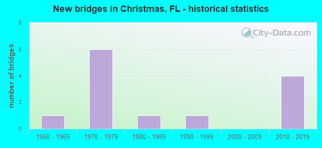
- New bridges - historical statistics
- 11960-1969
- 61970-1979
- 11980-1989
- 11990-1999
- 42010-2019


- Bridge Condition - Deck
- 9.1%Very good
- 72.7%Good
- 9.1%Satisfactory
- 9.1%Fair

- Bridge Condition - Superstructure
- 9.1%Very good
- 63.6%Good
- 18.2%Satisfactory
- 9.1%Fair

- Bridge Condition - Substructure
- 9.1%Very good
- 45.5%Good
- 27.3%Satisfactory
- 18.2%Fair

- Bridge Condition - Channel
- 23.1%Very good
- 23.1%Good
- 53.8%Satisfactory

- Bridge Condition - Culverts
- 50.0%Very good
- 50.0%Good
Find on map >> Show street view
Structure Number: 3407, Location: 2.23MI EAST OF I-75 (Lat: 26.273314, Lng: -81.702392), Route carried "on" structure: County highway , Year Built: 1997, Status: Open, Structure Length: 1.16m (3.81ft), Average Daily Traffic: 101 (year 2021), Truck Traffic: 5%, Average Future Daily Traffic: 126 (year 2041), Design Load: HS 20, Features Intersected: COCOHATCHEE CANAL, Facility Carried by Structure: NURSERY LANE
Minimum Vertical Clearance: 30+ m (98+ ft), Kilometerpoint: 0.000, Lanes on structure: 2, Owner: County Highway Agency, Approaching Roadway Width: 7.4m (24.3ft), Material/Design: Prestressed concrete, Design/Construction: Frame, Number Of Spans In Main Unit: 1, Length of Maximum Span: 11.6m (38.1ft), Curb or Sidewalk Widths: Left: 0.9m (3.0ft), Right: 0.0m, Curb-To-Curb Width: 8.2m (26.9ft), Out-to-Out Width: 9.9m (32.5ft)
Condition: Deck: Fair, Superstructure: Fair, Substructure: Good, Channel: Good, Operating Rating: 77.6 metric tons, Method Used To Determine Operating Rating: Load Factor (LF), Inventory Rating: 35.1 metric tons, Method Used To Determine Inventory Rating: Load Factor (LF), Structural Evaluation: Somewhat better than minimum adequacy, Deck Geometry: Somewhat better than minimum adequacy, Waterway Adequacy: Equal to present desirable criteria, Approach Roadway Alignment: Better than present minimum criteria, Designated Inspection Frequency: Every 24 months, Underwater Inspection Frequency: Every 24 months, Inspection Date: Febuary 2021, Underwater Inspection Date: January 2021, Deck Structure Type: Concrete Precast Panels, Wearing Surface/Protective System: Wearing Surface: Bituminous
Find on map >> Show street view
Structure Number: 700013, Location: SR-50 WB -St Johns River (Lat: 28.543786, Lng: -80.932942), Route carried "on" structure: State highway 50, Year Built: 1971, Status: Open, Structure Length: 7.01m (23.00ft), Average Daily Traffic: 6,100 (year 2020), Truck Traffic: 5%, Average Future Daily Traffic: 10,584 (year 2042), Design Load: HS 20, Features Intersected: St. Johns River
Minimum Vertical Clearance: 30+ m (98+ ft), Kilometerpoint: 0.000, Lanes on structure: 2, Base Highway Network: Yes, Owner: State Highway Agency, Approaching Roadway Width: 9.8m (32.2ft), Skew: 2 degrees, Material/Design: Prestressed concrete, Design/Construction: Stringer/Multi-beam, Number Of Spans In Main Unit: 5, Length of Maximum Span: 13.7m (44.9ft), Curb-To-Curb Width: 12.2m (40.0ft), Out-to-Out Width: 12.8m (42.0ft)
Condition: Deck: Good, Superstructure: Good, Substructure: Fair, Channel: Good, Operating Rating: 54.5 metric tons, Method Used To Determine Operating Rating: Load Factor (LF), Inventory Rating: 33.9 metric tons, Method Used To Determine Inventory Rating: Load Factor (LF), Structural Evaluation: Somewhat better than minimum adequacy, Deck Geometry: Better than present minimum criteria, Waterway Adequacy: Equal to present desirable criteria, Approach Roadway Alignment: Equal to present desirable criteria, Designated Inspection Frequency: Every 24 months, Underwater Inspection Frequency: Every 24 months, Inspection Date: December 2021, Underwater Inspection Date: December 2021, Deck Structure Type: Concrete Cast-file-Place, Wearing Surface/Protective System: Wearing Surface: Monolithic Concrete
Find on map >> Show street view
Structure Number: 700107, Location: SR-50 EB -St Johns River (Lat: 28.543600, Lng: -80.932803), Route carried "on" structure: State highway 50, Year Built: 1971, Status: Open, Structure Length: 7.01m (23.00ft), Average Daily Traffic: 6,100 (year 2020), Truck Traffic: 5%, Average Future Daily Traffic: 10,584 (year 2042), Design Load: HS 20, Features Intersected: St. Johns River
Minimum Vertical Clearance: 30+ m (98+ ft), Kilometerpoint: 0.000, Lanes on structure: 2, Base Highway Network: Yes, Owner: State Highway Agency, Approaching Roadway Width: 8.5m (27.9ft), Skew: 2 degrees, Material/Design: Prestressed concrete, Design/Construction: Stringer/Multi-beam, Number Of Spans In Main Unit: 5, Length of Maximum Span: 13.7m (44.9ft), Curb-To-Curb Width: 12.2m (40.0ft), Out-to-Out Width: 12.8m (42.0ft)
Condition: Deck: Good, Superstructure: Good, Substructure: Fair, Channel: Good, Operating Rating: 54.5 metric tons, Method Used To Determine Operating Rating: Load Factor (LF), Inventory Rating: 33.9 metric tons, Method Used To Determine Inventory Rating: Load Factor (LF), Structural Evaluation: Somewhat better than minimum adequacy, Deck Geometry: Better than present minimum criteria, Waterway Adequacy: Equal to present desirable criteria, Approach Roadway Alignment: Equal to present desirable criteria, Length Of Structure Improvement: 14.00m (45.93ft), Designated Inspection Frequency: Every 24 months, Underwater Inspection Frequency: Every 24 months, Inspection Date: December 2021, Underwater Inspection Date: December 2021, Bridge Improvement Cost: $83,000, Total Project Cost: $109,000, Deck Structure Type: Concrete Cast-file-Place, Wearing Surface/Protective System: Wearing Surface: Monolithic Concrete
Find on map >> Show street view
Structure Number: 750015, Location: SR-50 WB - St Johns R Rel (Lat: 28.541703, Lng: -80.950719), Route carried "on" structure: State highway 50, Year Built: 1971, Status: Open, Structure Length: 4.71m (15.45ft), Average Daily Traffic: 6,100 (year 2020), Truck Traffic: 5%, Average Future Daily Traffic: 10,584 (year 2042), Design Load: HS 20, Features Intersected: St Johns River Relief
Minimum Vertical Clearance: 30+ m (98+ ft), Kilometerpoint: 44.865, Lanes on structure: 2, Base Highway Network: Yes, Owner: State Highway Agency, Approaching Roadway Width: 8.6m (28.2ft), Material/Design: Concrete, Design/Construction: Slab, Number Of Spans In Main Unit: 5, Length of Maximum Span: 9.4m (30.8ft), Curb-To-Curb Width: 12.2m (40.0ft), Out-to-Out Width: 12.9m (42.3ft)
Condition: Deck: Good, Superstructure: Good, Substructure: Good, Channel: Satisfactory, Operating Rating: 66.8 metric tons, Method Used To Determine Operating Rating: Load Factor (LF), Inventory Rating: 40.1 metric tons, Method Used To Determine Inventory Rating: Load Factor (LF), Structural Evaluation: Better than present minimum criteria, Deck Geometry: Better than present minimum criteria, Waterway Adequacy: Equal to present desirable criteria, Approach Roadway Alignment: Equal to present desirable criteria, Designated Inspection Frequency: Every 24 months, Underwater Inspection Frequency: Every 24 months, Inspection Date: September 2021, Underwater Inspection Date: September 2021, Deck Structure Type: Concrete Cast-file-Place, Wearing Surface/Protective System: Wearing Surface: Monolithic Concrete
Find on map >> Show street view
Structure Number: 750016, Location: SR-50 WB - St Johns R (Lat: 28.542900, Lng: -80.942872), Route carried "on" structure: State highway 50, Year Built: 1967, Status: Open, Structure Length: 30.54m (100.20ft), Average Daily Traffic: 6,100 (year 2020), Truck Traffic: 5%, Average Future Daily Traffic: 10,584 (year 2042), Design Load: HS 20, Features Intersected: St Johns River
Minimum Vertical Clearance: 30+ m (98+ ft), Kilometerpoint: 45.536, Lanes on structure: 2, Base Highway Network: Yes, Owner: State Highway Agency, Approaching Roadway Width: 9.8m (32.2ft), Skew: 4 degrees, Material/Design: Prestressed concrete, Design/Construction: Stringer/Multi-beam, Number Of Spans In Main Unit: 20, Length of Maximum Span: 15.2m (49.9ft), Curb-To-Curb Width: 9.2m (30.2ft), Out-to-Out Width: 10.7m (35.1ft)
Condition: Deck: Good, Superstructure: Good, Substructure: Good, Channel: Very good, Operating Rating: 66.1 metric tons, Method Used To Determine Operating Rating: Load Factor (LF), Inventory Rating: 39.6 metric tons, Method Used To Determine Inventory Rating: Load Factor (LF), Structural Evaluation: Better than present minimum criteria, Deck Geometry: Meets minimum limits, Waterway Adequacy: Equal to present desirable criteria, Approach Roadway Alignment: Equal to present desirable criteria, Designated Inspection Frequency: Every 24 months, Underwater Inspection Frequency: Every 24 months, Inspection Date: September 2021, Underwater Inspection Date: September 2021, Deck Structure Type: Concrete Cast-file-Place, Wearing Surface/Protective System: Wearing Surface: Monolithic Concrete, Membrane: Epoxy, Deck Protection: Bituminous
Find on map >> Show street view
Structure Number: 75017, Location: SR-50 EB - St Johns R Rel (Lat: 28.541514, Lng: -80.950708), Route carried "on" structure: State highway 50, Year Built: 1971, Status: Open, Structure Length: 4.72m (15.49ft), Average Daily Traffic: 6,100 (year 2020), Truck Traffic: 5%, Average Future Daily Traffic: 10,584 (year 2042), Design Load: HS 20, Features Intersected: St Johns River Relief
Minimum Vertical Clearance: 30+ m (98+ ft), Kilometerpoint: 44.865, Lanes on structure: 2, Base Highway Network: Yes, Owner: State Highway Agency, Approaching Roadway Width: 8.8m (28.9ft), Material/Design: Concrete, Design/Construction: Slab, Number Of Spans In Main Unit: 5, Length of Maximum Span: 9.4m (30.8ft), Curb-To-Curb Width: 12.2m (40.0ft), Out-to-Out Width: 12.8m (42.0ft)
Condition: Deck: Satisfactory, Superstructure: Satisfactory, Substructure: Good, Channel: Satisfactory, Operating Rating: 66.8 metric tons, Method Used To Determine Operating Rating: Load Factor (LF), Inventory Rating: 40.1 metric tons, Method Used To Determine Inventory Rating: Load Factor (LF), Structural Evaluation: Equal to present minimum criteria, Deck Geometry: Better than present minimum criteria, Waterway Adequacy: Equal to present desirable criteria, Approach Roadway Alignment: Equal to present desirable criteria, Designated Inspection Frequency: Every 24 months, Underwater Inspection Frequency: Every 24 months, Inspection Date: September 2021, Underwater Inspection Date: September 2021, Deck Structure Type: Concrete Cast-file-Place, Wearing Surface/Protective System: Wearing Surface: Monolithic Concrete
Find on map >> Show street view
Structure Number: 750171, Location: SR-50 EB - St Johns R (Lat: 28.542764, Lng: -80.942700), Route carried "on" structure: State highway 50, Year Built: 1971, Status: Open, Structure Length: 30.54m (100.20ft), Average Daily Traffic: 6,100 (year 2020), Truck Traffic: 5%, Average Future Daily Traffic: 10,584 (year 2042), Design Load: HS 20, Features Intersected: St Johns River
Minimum Vertical Clearance: 30+ m (98+ ft), Kilometerpoint: 45.536, Lanes on structure: 2, Base Highway Network: Yes, Owner: State Highway Agency, Approaching Roadway Width: 9.6m (31.5ft), Skew: 4 degrees, Material/Design: Prestressed concrete, Design/Construction: Stringer/Multi-beam, Number Of Spans In Main Unit: 20, Length of Maximum Span: 15.7m (51.5ft), Curb-To-Curb Width: 12.3m (40.4ft), Out-to-Out Width: 13.0m (42.7ft)
Condition: Deck: Good, Superstructure: Good, Substructure: Satisfactory, Channel: Very good, Operating Rating: 56.5 metric tons, Method Used To Determine Operating Rating: Load Factor (LF), Inventory Rating: 33.9 metric tons, Method Used To Determine Inventory Rating: Load Factor (LF), Structural Evaluation: Equal to present minimum criteria, Deck Geometry: Better than present minimum criteria, Waterway Adequacy: Equal to present desirable criteria, Approach Roadway Alignment: Equal to present desirable criteria, Designated Inspection Frequency: Every 24 months, Underwater Inspection Frequency: Every 24 months, Inspection Date: September 2021, Underwater Inspection Date: September 2021, Deck Structure Type: Concrete Cast-file-Place, Wearing Surface/Protective System: Wearing Surface: Monolithic Concrete, Membrane: Epoxy, Deck Protection: Bituminous
Find on map >> Show street view
Structure Number: 754063, Location: 2.6 mi North of SR-50 (Lat: 28.569333, Lng: -81.026678), Route carried "on" structure: County highway , Year Built: 1979, Status: Open, Structure Length: 0.82m (2.69ft), Average Daily Traffic: 1,114 (year 2021), Truck Traffic: 5%, Average Future Daily Traffic: 1,292 (year 2042), Design Load: H 20, Features Intersected: Christmas Creek, Facility Carried by Structure: Fort Christmas Rd
Minimum Vertical Clearance: 30+ m (98+ ft), Kilometerpoint: 18.926, Lanes on structure: 2, Owner: County Highway Agency, Approaching Roadway Width: 7.4m (24.3ft), Skew: 1 degrees, Material/Design: Concrete, Design/Construction: Culvert, Number Of Spans In Main Unit: 3, Length of Maximum Span: 2.6m (8.5ft)
Condition: Channel: Satisfactory, Culverts: Good, Operating Rating: 52.4 metric tons, Method Used To Determine Operating Rating: Load Factor (LF), Inventory Rating: 31.5 metric tons, Method Used To Determine Inventory Rating: Load Factor (LF), Structural Evaluation: Better than present minimum criteria, Waterway Adequacy: Better than present minimum criteria, Approach Roadway Alignment: Equal to present desirable criteria, Designated Inspection Frequency: Every 24 months, Underwater Inspection Frequency: Every 24 months, Inspection Date: October 2021, Underwater Inspection Date: October 2021
Find on map >> Show street view
Structure Number: 754156, Location: 2.6 Miles South of SR 50 (Lat: 28.501300, Lng: -81.000542), Route carried "on" structure: County highway , Year Built: 2011, Status: Open, Structure Length: 4.60m (15.09ft), Average Daily Traffic: 650 (year 2021), Truck Traffic: 29%, Average Future Daily Traffic: 1,128 (year 2042), Design Load: HL 93, Features Intersected: Tootoosahatchee Creek, Facility Carried by Structure: Taylor Creek Road
Minimum Vertical Clearance: 30.45m (99.90ft), Kilometerpoint: 4.496, Lanes on structure: 2, Owner: County Highway Agency, Approaching Roadway Width: 12.2m (40.0ft), Material/Design: Prestressed concrete, Design/Construction: Stringer/Multi-beam, Number Of Spans In Main Unit: 3, Length of Maximum Span: 15.4m (50.5ft), Curb-To-Curb Width: 12.2m (40.0ft), Out-to-Out Width: 13.1m (43.0ft)
Condition: Deck: Very good, Superstructure: Very good, Substructure: Very good, Channel: Very good, Operating Rating: 49.4 metric tons, Method Used To Determine Operating Rating: Load and Resistance Factor (LRFR), Inventory Rating: 36.9 metric tons, Method Used To Determine Inventory Rating: Load and Resistance Factor (LRFR), Structural Evaluation: Equal to present desirable criteria, Deck Geometry: Equal to present desirable criteria, Waterway Adequacy: Equal to present desirable criteria, Approach Roadway Alignment: Equal to present desirable criteria, Designated Inspection Frequency: Every 24 months, Inspection Date: April 2021, Deck Structure Type: Concrete Cast-file-Place
Find on map >> Show street view
Structure Number: 754321, Location: 0.2 Miles N. of SR-50 (Lat: 28.539692, Lng: -81.019211), Route carried "on" structure: County highway 420, Year Built: 1982, Status: Open, Structure Length: 4.02m (13.19ft), Average Daily Traffic: 2,800 (year 2021), Truck Traffic: 2%, Average Future Daily Traffic: 1,277 (year 2042), Design Load: HS 20, Features Intersected: Savage Creek, Facility Carried by Structure: Fort Christmas Rd
Minimum Vertical Clearance: 30+ m (98+ ft), Kilometerpoint: 14.717, Lanes on structure: 2, Owner: County Highway Agency, Approaching Roadway Width: 7.5m (24.6ft), Material/Design: Prestressed concrete, Design/Construction: Slab, Number Of Spans In Main Unit: 4, Length of Maximum Span: 10.1m (33.1ft), Curb-To-Curb Width: 10.4m (34.1ft), Out-to-Out Width: 11.2m (36.7ft)
Condition: Deck: Good, Superstructure: Good, Substructure: Good, Channel: Satisfactory, Operating Rating: 43.3 metric tons, Method Used To Determine Operating Rating: Load and Resistance Factor (LRFR), Inventory Rating: 29.4 metric tons, Method Used To Determine Inventory Rating: Load and Resistance Factor (LRFR), Structural Evaluation: Better than present minimum criteria, Deck Geometry: Somewhat better than minimum adequacy, Waterway Adequacy: Equal to present desirable criteria, Approach Roadway Alignment: Equal to present desirable criteria, Designated Inspection Frequency: Every 24 months, Underwater Inspection Frequency: Every 24 months, Inspection Date: October 2021, Underwater Inspection Date: October 2021, Deck Structure Type: Concrete Precast Panels, Wearing Surface/Protective System: Wearing Surface: Bituminous
Find on map >> Show street view
Structure Number: 770802, Location: Charles Bronson St. Frst (Lat: 28.649694, Lng: -81.031533), Route carried "on" structure: ServiceState lands road 5, Year Built: 2010, Status: Posted for load, Structure Length: 1.08m (3.54ft), Average Daily Traffic: 5 (year 2018), Average Future Daily Traffic: 5 (year 2025), Features Intersected: Buck Point Canal
Minimum Vertical Clearance: 30+ m (98+ ft), Kilometerpoint: 0.000, Lanes on structure: 1, Owner: State Agenciy, Maintenance Responsibility: State Park, Forest, or Reservation Agency, Approaching Roadway Width: 3.7m (12.1ft), Material/Design: Steel, Design/Construction: Stringer/Multi-beam, Number Of Spans In Main Unit: 1, Length of Maximum Span: 10.8m (35.4ft), Curb-To-Curb Width: 3.7m (12.1ft), Out-to-Out Width: 3.9m (12.8ft)
Condition: Deck: Good, Superstructure: Satisfactory, Substructure: Satisfactory, Channel: Satisfactory, Operating Rating: 12.7 metric tons, Method Used To Determine Operating Rating: Load and Resistance Factor (LRFR), Inventory Rating: 9.8 metric tons, Method Used To Determine Inventory Rating: Load and Resistance Factor (LRFR), Structural Evaluation: High priority of corrective action, Deck Geometry: Meets minimum limits, Waterway Adequacy: Better than present minimum criteria, Approach Roadway Alignment: Equal to present desirable criteria, Bridge Posting: Required (Relationship of Operating Rating to Maximum Legal Load: > 39.9% below), Designated Inspection Frequency: Every 24 months, Other Special Inspection Frequency: Every 24 months, Inspection Date: October 2020, Other Special Inspection Date: October 2021, Deck Structure Type: Wood or Timber
Find on map >> Show street view
Structure Number: 770803, Location: Charles Bronson St. Frst (Lat: 28.613278, Lng: -81.030619), Route carried "on" structure: ServiceState lands road , Year Built: 2010, Status: Posted for load, Structure Length: 1.06m (3.48ft), Average Daily Traffic: 1 (year 2018), Average Future Daily Traffic: 1 (year 2028), Features Intersected: Joshua Creek Canal, Facility Carried by Structure: State Forest Road
Minimum Vertical Clearance: 30+ m (98+ ft), Kilometerpoint: 0.000, Lanes on structure: 1, Owner: State Agenciy, Maintenance Responsibility: State Park, Forest, or Reservation Agency, Approaching Roadway Width: 3.7m (12.1ft), Material/Design: Steel, Design/Construction: Stringer/Multi-beam, Number Of Spans In Main Unit: 1, Length of Maximum Span: 10.6m (34.8ft), Curb-To-Curb Width: 3.7m (12.1ft), Out-to-Out Width: 3.9m (12.8ft)
Condition: Deck: Good, Superstructure: Good, Substructure: Satisfactory, Channel: Satisfactory, Operating Rating: 12.7 metric tons, Method Used To Determine Operating Rating: Load and Resistance Factor (LRFR), Inventory Rating: 9.8 metric tons, Method Used To Determine Inventory Rating: Load and Resistance Factor (LRFR), Structural Evaluation: High priority of corrective action, Deck Geometry: Meets minimum limits, Waterway Adequacy: Better than present minimum criteria, Approach Roadway Alignment: Equal to present desirable criteria, Bridge Posting: Required (Relationship of Operating Rating to Maximum Legal Load: > 39.9% below), Designated Inspection Frequency: Every 24 months, Other Special Inspection Frequency: Every 24 months, Inspection Date: October 2020, Other Special Inspection Date: October 2021, Deck Structure Type: Wood or Timber
Find on map >> Show street view
Structure Number: 774071, Location: 2.2 MI E/O Lake Mills Rd (Lat: 28.623789, Lng: -81.067375), Route carried "on" structure: County highway , Year Built: 2019, Status: Open, Structure Length: 0.66m (2.17ft), Average Daily Traffic: 501 (year 2021), Truck Traffic: 2%, Average Future Daily Traffic: 869 (year 2042), Design Load: HL 93, Features Intersected: Robert's Branch Creek, Facility Carried by Structure: Curryville Road
Minimum Vertical Clearance: 30+ m (98+ ft), Kilometerpoint: 0.000, Lanes on structure: 2, Owner: County Highway Agency, Approaching Roadway Width: 6.9m (22.6ft), Skew: 1 degrees, Material/Design: Concrete, Design/Construction: Culvert, Number Of Spans In Main Unit: 2, Length of Maximum Span: 3.1m (10.2ft)
Condition: Channel: Satisfactory, Culverts: Very good, Operating Rating: 47.7 metric tons, Method Used To Determine Operating Rating: Load and Resistance Factor (LRFR), Inventory Rating: 36.6 metric tons, Method Used To Determine Inventory Rating: Load and Resistance Factor (LRFR), Structural Evaluation: Equal to present desirable criteria, Waterway Adequacy: Equal to present desirable criteria, Approach Roadway Alignment: Equal to present desirable criteria, Designated Inspection Frequency: Every 24 months, Inspection Date: April 2021