Bridge Statistics for Chilhowie, Virginia (VA)
Condition, Traffic, Stress, Structural Evaluation, Project Costs
- National Bridge Inventory (NBI) Statistics
- 27Number of bridges
- 230ft / 70.0mTotal length
- $3,211,000Total costs
- 133,630Total average daily traffic
- 19,926Total average daily truck traffic
- National Bridge Inventory (NBI) Registered Bridges for Chilhowie
- No street view available for this location
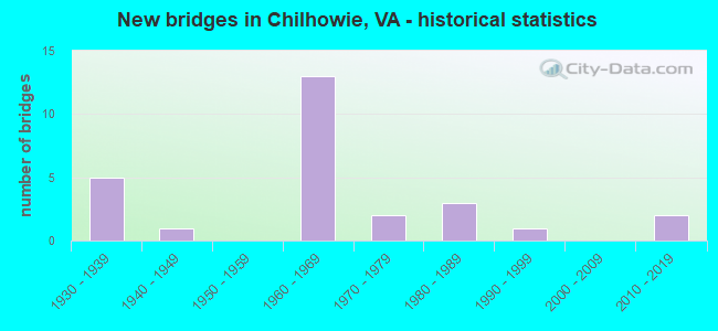
- New bridges - historical statistics
- 51930-1939
- 11940-1949
- 131960-1969
- 21970-1979
- 31980-1989
- 11990-1999
- 22010-2019

- Reconstructed bridges - Historical Statistics
- 71980-1989
- 01990-1999
- 02000-2009
- 12010-2019


- Bridge Condition - Deck
- 36.8%Good
- 36.8%Satisfactory
- 21.1%Fair
- 5.3%Poor

- Bridge Condition - Superstructure
- 5.3%Very good
- 36.8%Good
- 21.1%Satisfactory
- 26.3%Fair
- 10.5%Poor

- Bridge Condition - Substructure
- 5.3%Very good
- 21.1%Good
- 47.4%Satisfactory
- 26.3%Fair

- Bridge Condition - Channel
- 5.6%Very good
- 22.2%Good
- 33.3%Satisfactory
- 38.9%Fair

- Bridge Condition - Culverts
- 75.0%Satisfactory
- 25.0%Fair
Find on map >> Show street view
Structure Number: 5541, Location: 0.80-RT658W; 0.00-RT658E (Lat: 37.423664, Lng: -80.381992), Route carried "on" structure: County highway 632, Year Built: 1940, Year Reconstructed: 1994, Status: Open, Structure Length: 1.28m (4.20ft), Average Daily Traffic: 190 (year 2020), Average Future Daily Traffic: 209 (year 2040), Features Intersected: Dicks Creek
Minimum Vertical Clearance: 30+ m (98+ ft), Kilometerpoint: 8.850, Lanes on structure: 2, Owner: State Highway Agency, Approaching Roadway Width: 4.3m (14.1ft), Material/Design: Steel, Design/Construction: Stringer/Multi-beam, Number Of Spans In Main Unit: 1, Length of Maximum Span: 12.8m (42.0ft), Curb or Sidewalk Widths: Left: 0.2m (0.7ft), Right: 0.2m (0.7ft), Curb-To-Curb Width: 5.5m (18.0ft), Out-to-Out Width: 5.9m (19.4ft)
Condition: Deck: Good, Superstructure: Good, Substructure: Satisfactory, Channel: Very good, Operating Rating: 51.7 metric tons, Method Used To Determine Operating Rating: Load and Resistance Factor (LRFR), Inventory Rating: 39.9 metric tons, Method Used To Determine Inventory Rating: Load and Resistance Factor (LRFR), Structural Evaluation: Equal to present minimum criteria, Deck Geometry: High priority of corrective action, Waterway Adequacy: Better than present minimum criteria, Approach Roadway Alignment: Equal to present desirable criteria, Designated Inspection Frequency: Every 24 months, Inspection Date: July 2020, Deck Structure Type: Wood or Timber, Wearing Surface/Protective System: Wearing Surface: Bituminous
Find on map >> Show street view
Structure Number: 17381, Location: 1.4 FRRT107-7.48TOMARION (Lat: 36.813061, Lng: -81.662489), Route carried "on" structure: US 11, Year Built: 1932, Status: Open, Structure Length: 0.67m (2.20ft), Average Daily Traffic: 5,925 (year 2020), Truck Traffic: 4%, Average Future Daily Traffic: 6,518 (year 2040), Design Load: H 20, Features Intersected: BRANCH, Facility Carried by Structure: LEE HIGHWAY
Minimum Vertical Clearance: 30+ m (98+ ft), Kilometerpoint: 57.177, Lanes on structure: 3, Base Highway Network: Yes, Owner: State Highway Agency, Approaching Roadway Width: 9.8m (32.2ft), Skew: 3 degrees, Material/Design: Concrete, Design/Construction: Slab, Number Of Spans In Main Unit: 1, Length of Maximum Span: 5.9m (19.4ft), Curb or Sidewalk Widths: Left: 0.0m, Right: 0.2m (0.7ft), Curb-To-Curb Width: 18.3m (60.0ft), Out-to-Out Width: 19.2m (63.0ft)
Condition: Deck: Satisfactory, Superstructure: Satisfactory, Substructure: Satisfactory, Channel: Fair, Operating Rating: 49.0 metric tons, Method Used To Determine Operating Rating: Load and Resistance Factor (LRFR), Inventory Rating: 38.1 metric tons, Method Used To Determine Inventory Rating: Load and Resistance Factor (LRFR), Structural Evaluation: Equal to present minimum criteria, Deck Geometry: Superior to present desirable criteria, Waterway Adequacy: Better than present minimum criteria, Approach Roadway Alignment: Better than present minimum criteria, Length Of Structure Improvement: 0.67m (2.20ft), Designated Inspection Frequency: Every 24 months, Inspection Date: March 2021, Bridge Improvement Cost: $132,000, Roadway Improvement Cost: $25,000, Total Project Cost: $205,000 ( Estimate for 2015), Deck Structure Type: Concrete Cast-file-Place, Wearing Surface/Protective System: Wearing Surface: Bituminous
Find on map >> Show street view
Structure Number: 17422, Location: 1.31 Fr 762; 2.56 To 11 (Lat: 36.807469, Lng: -81.663325), Route carried "on" structure: Interstate 81, Year Built: 1962, Status: Open, Structure Length: 3.60m (11.81ft), Average Daily Traffic: 14,285 (year 2020), Truck Traffic: 21%, Average Future Daily Traffic: 19,999 (year 2040), Design Load: HS 20, Features Intersected: RTE 638 TATTLE BRANCH RD
Minimum Vertical Clearance: 30+ m (98+ ft), Kilometerpoint: 59.745, Lanes on structure: 2, Lanes under structure: 2, Base Highway Network: Yes, Owner: State Highway Agency, Approaching Roadway Width: 12.8m (42.0ft), Material/Design: Concrete, Design/Construction: Tee Beam, Number Of Spans In Main Unit: 3, Length of Maximum Span: 11.3m (37.1ft), Curb-To-Curb Width: 12.8m (42.0ft), Out-to-Out Width: 13.4m (44.0ft)
Condition: Deck: Fair, Superstructure: Fair, Substructure: Satisfactory, Operating Rating: 55.3 metric tons, Method Used To Determine Operating Rating: Load and Resistance Factor (LRFR), Inventory Rating: 42.6 metric tons, Method Used To Determine Inventory Rating: Load and Resistance Factor (LRFR), Structural Evaluation: Somewhat better than minimum adequacy, Deck Geometry: Equal to present desirable criteria, Underclear: Meets minimum limits, Approach Roadway Alignment: Better than present minimum criteria, Length Of Structure Improvement: 3.60m (11.81ft), Designated Inspection Frequency: Every 24 months, Inspection Date: Febuary 2020, Bridge Improvement Cost: $375,000, Roadway Improvement Cost: $30,000, Total Project Cost: $527,000 ( Estimate for 2014), Deck Structure Type: Concrete Cast-file-Place, Wearing Surface/Protective System: Wearing Surface: Latex Concrete
Find on map >> Show street view
Structure Number: 17424, Location: 1.31 FR 762-2.56 TO 11 (Lat: 36.807325, Lng: -81.663197), Route carried "on" structure: Interstate 81, Year Built: 1962, Status: Open, Structure Length: 3.26m (10.70ft), Average Daily Traffic: 15,752 (year 2020), Truck Traffic: 21%, Average Future Daily Traffic: 22,053 (year 2040), Design Load: HS 20, Features Intersected: RTE 638 TATTLE BRANCH RD
Minimum Vertical Clearance: 30+ m (98+ ft), Kilometerpoint: 59.243, Lanes on structure: 2, Lanes under structure: 2, Base Highway Network: Yes, Owner: State Highway Agency, Approaching Roadway Width: 12.8m (42.0ft), Material/Design: Concrete, Design/Construction: Tee Beam, Number Of Spans In Main Unit: 3, Length of Maximum Span: 11.3m (37.1ft), Curb-To-Curb Width: 12.8m (42.0ft), Out-to-Out Width: 13.4m (44.0ft)
Condition: Deck: Satisfactory, Superstructure: Fair, Substructure: Satisfactory, Operating Rating: 50.8 metric tons, Method Used To Determine Operating Rating: Load and Resistance Factor (LRFR), Inventory Rating: 39.0 metric tons, Method Used To Determine Inventory Rating: Load and Resistance Factor (LRFR), Structural Evaluation: Somewhat better than minimum adequacy, Deck Geometry: Equal to present desirable criteria, Underclear: Meets minimum limits, Approach Roadway Alignment: Better than present minimum criteria, Length Of Structure Improvement: 3.26m (10.70ft), Designated Inspection Frequency: Every 24 months, Inspection Date: Febuary 2020, Bridge Improvement Cost: $340,000, Roadway Improvement Cost: $30,000, Total Project Cost: $481,000 ( Estimate for 2014), Deck Structure Type: Concrete Cast-file-Place, Wearing Surface/Protective System: Wearing Surface: Latex Concrete
Find on map >> Show street view
Structure Number: 17426, Location: 0.69 FR WCL - .50 TO 762 (Lat: 36.789392, Lng: -81.687197), Route carried "on" structure: Interstate 81, Year Built: 1962, Year Reconstructed: 1985, Status: Open, Structure Length: 7.27m (23.85ft), Average Daily Traffic: 13,771 (year 2020), Truck Traffic: 19%, Average Future Daily Traffic: 19,279 (year 2042), Design Load: HS 20+Mod, Features Intersected: M. FORK HOLSTON RIVER
Minimum Vertical Clearance: 30+ m (98+ ft), Kilometerpoint: 56.862, Lanes on structure: 2, Base Highway Network: Yes, Owner: State Highway Agency, Approaching Roadway Width: 11.6m (38.1ft), Skew: 4 degrees, Material/Design: Steel, Design/Construction: Stringer/Multi-beam, Number Of Spans In Main Unit: 4, Length of Maximum Span: 18.1m (59.4ft), Curb or Sidewalk Widths: Left: 0.8m (2.6ft), Right: 0.8m (2.6ft), Curb-To-Curb Width: 9.1m (29.9ft), Out-to-Out Width: 11.5m (37.7ft)
Condition: Deck: Fair, Superstructure: Poor, Substructure: Fair, Channel: Good, Operating Rating: 64.4 metric tons, Method Used To Determine Operating Rating: Load and Resistance Factor (LRFR), Inventory Rating: 49.0 metric tons, Method Used To Determine Inventory Rating: Load and Resistance Factor (LRFR), Structural Evaluation: Meets minimum limits, Deck Geometry: Meets minimum limits, Waterway Adequacy: Better than present minimum criteria, Approach Roadway Alignment: Equal to present desirable criteria, Designated Inspection Frequency: Every 24 months, Other Special Inspection Frequency: Every 12 months, Inspection Date: Febuary 2022, Other Special Inspection Date: Febuary 2022, Deck Structure Type: Concrete Cast-file-Place, Wearing Surface/Protective System: Wearing Surface: Latex Concrete
Find on map >> Show street view
Structure Number: 17427, Location: 0.69 FR WCL - .50 TO 762 (Lat: 36.789161, Lng: -81.687203), Route carried "on" structure: Interstate 81, Year Built: 1962, Year Reconstructed: 1985, Status: Open, Structure Length: 7.24m (23.75ft), Average Daily Traffic: 15,676 (year 2020), Truck Traffic: 22%, Average Future Daily Traffic: 21,946 (year 2042), Design Load: HS 20+Mod, Features Intersected: M. FORK HOLSTON RIVER
Minimum Vertical Clearance: 30+ m (98+ ft), Kilometerpoint: 56.267, Lanes on structure: 2, Base Highway Network: Yes, Owner: State Highway Agency, Approaching Roadway Width: 12.2m (40.0ft), Skew: 4 degrees, Material/Design: Steel, Design/Construction: Stringer/Multi-beam, Number Of Spans In Main Unit: 4, Length of Maximum Span: 18.0m (59.1ft), Curb or Sidewalk Widths: Left: 0.8m (2.6ft), Right: 0.8m (2.6ft), Curb-To-Curb Width: 9.1m (29.9ft), Out-to-Out Width: 11.5m (37.7ft)
Condition: Deck: Poor, Superstructure: Poor, Substructure: Fair, Channel: Satisfactory, Operating Rating: 58.1 metric tons, Method Used To Determine Operating Rating: Load and Resistance Factor (LRFR), Inventory Rating: 44.5 metric tons, Method Used To Determine Inventory Rating: Load and Resistance Factor (LRFR), Structural Evaluation: Meets minimum limits, Deck Geometry: Meets minimum limits, Waterway Adequacy: Better than present minimum criteria, Approach Roadway Alignment: Equal to present desirable criteria, Length Of Structure Improvement: 8.84m (29.00ft), Designated Inspection Frequency: Every 12 months, Inspection Date: Febuary 2022, Bridge Improvement Cost: $957,000, Roadway Improvement Cost: $50,000, Total Project Cost: $1,309,000 ( Estimate for 2019), Deck Structure Type: Concrete Cast-file-Place, Wearing Surface/Protective System: Wearing Surface: Latex Concrete
Find on map >> Show street view
Structure Number: 17428, Location: AT EXIT 35 OF I-81 (Lat: 36.794528, Lng: -81.680817), Route carried "on" structure: Interstate 81, Year Built: 1963, Year Reconstructed: 1987, Status: Open, Structure Length: 4.17m (13.68ft), Average Daily Traffic: 13,771 (year 2020), Truck Traffic: 19%, Average Future Daily Traffic: 19,279 (year 2040), Design Load: HS 20+Mod, Features Intersected: SR-107
Minimum Vertical Clearance: 30+ m (98+ ft), Kilometerpoint: 57.667, Lanes on structure: 2, Lanes under structure: 2, Base Highway Network: Yes, Owner: State Highway Agency, Approaching Roadway Width: 11.9m (39.0ft), Skew: 2 degrees, Material/Design: Steel, Design/Construction: Stringer/Multi-beam, Number Of Spans In Main Unit: 3, Length of Maximum Span: 14.5m (47.6ft), Curb-To-Curb Width: 12.8m (42.0ft), Out-to-Out Width: 13.4m (44.0ft)
Condition: Deck: Fair, Superstructure: Fair, Substructure: Good, Operating Rating: 46.3 metric tons, Method Used To Determine Operating Rating: Load and Resistance Factor (LRFR), Inventory Rating: 35.4 metric tons, Method Used To Determine Inventory Rating: Load and Resistance Factor (LRFR), Structural Evaluation: Somewhat better than minimum adequacy, Deck Geometry: Equal to present desirable criteria, Underclear: Meets minimum limits, Approach Roadway Alignment: Better than present minimum criteria, Length Of Structure Improvement: 4.18m (13.71ft), Designated Inspection Frequency: Every 24 months, Inspection Date: May 2021, Bridge Improvement Cost: $452,000, Roadway Improvement Cost: $25,000, Total Project Cost: $620,000 ( Estimate for 2017), Deck Structure Type: Concrete Cast-file-Place, Wearing Surface/Protective System: Wearing Surface: Latex Concrete
Find on map >> Show street view
Structure Number: 1743, Location: AT EXIT 35 OF I-81 (Lat: 36.794356, Lng: -81.680733), Route carried "on" structure: Interstate 81, Year Built: 1963, Year Reconstructed: 1987, Status: Open, Structure Length: 4.17m (13.68ft), Average Daily Traffic: 15,752 (year 2020), Truck Traffic: 21%, Average Future Daily Traffic: 22,053 (year 2040), Design Load: HS 20+Mod, Features Intersected: SR-107
Minimum Vertical Clearance: 30+ m (98+ ft), Kilometerpoint: 57.071, Lanes on structure: 2, Lanes under structure: 2, Base Highway Network: Yes, Owner: State Highway Agency, Approaching Roadway Width: 11.9m (39.0ft), Skew: 2 degrees, Material/Design: Steel, Design/Construction: Stringer/Multi-beam, Number Of Spans In Main Unit: 3, Length of Maximum Span: 14.5m (47.6ft), Curb-To-Curb Width: 12.8m (42.0ft), Out-to-Out Width: 13.4m (44.0ft)
Condition: Deck: Good, Superstructure: Fair, Substructure: Good, Operating Rating: 52.6 metric tons, Method Used To Determine Operating Rating: Load and Resistance Factor (LRFR), Inventory Rating: 40.8 metric tons, Method Used To Determine Inventory Rating: Load and Resistance Factor (LRFR), Structural Evaluation: Somewhat better than minimum adequacy, Deck Geometry: Equal to present desirable criteria, Underclear: Meets minimum limits, Approach Roadway Alignment: Better than present minimum criteria, Designated Inspection Frequency: Every 24 months, Inspection Date: May 2021, Deck Structure Type: Concrete Cast-file-Place, Wearing Surface/Protective System: Wearing Surface: Latex Concrete
Find on map >> Show street view
Structure Number: 17499, Location: .05 TO R107 & 3.8 TO R11 (Lat: 36.795458, Lng: -81.680261), Route carried "on" structure: Interstate 81, Year Built: 1963, Status: Open, Structure Length: 1.28m (4.20ft), Average Daily Traffic: 2,151 (year 2020), Average Future Daily Traffic: 2,366 (year 2040), Design Load: HS 20, Features Intersected: Stream
Minimum Vertical Clearance: 30+ m (98+ ft), Kilometerpoint: 57.200, Lanes on structure: 4, Base Highway Network: Yes, Owner: State Highway Agency, Approaching Roadway Width: 36.0m (118.1ft), Skew: 3 degrees, Material/Design: Concrete, Design/Construction: Culvert, Number Of Spans In Main Unit: 4, Length of Maximum Span: 3.0m (9.8ft)
Condition: Channel: Fair, Culverts: Satisfactory, Operating Rating: 44.5 metric tons, Method Used To Determine Operating Rating: Field evaluation and documented engineering judgment, Inventory Rating: 32.7 metric tons, Method Used To Determine Inventory Rating: Field evaluation and documented engineering judgment, Structural Evaluation: Equal to present minimum criteria, Waterway Adequacy: Better than present minimum criteria, Approach Roadway Alignment: Better than present minimum criteria, Designated Inspection Frequency: Every 24 months, Inspection Date: June 2021
Find on map >> Show street view
Structure Number: 175, Location: .05 TO R107 & 3.82 TO R11 (Lat: 36.794444, Lng: -81.680008), Route carried "on" structure: Ramp Interstate 81, Year Built: 1963, Status: Open, Structure Length: 1.19m (3.90ft), Average Daily Traffic: 1,103 (year 2020), Average Future Daily Traffic: 1,544 (year 2040), Design Load: HS 20, Features Intersected: Stream
Minimum Vertical Clearance: 30+ m (98+ ft), Kilometerpoint: 57.264, Lanes on structure: 2, Base Highway Network: Yes, Owner: State Highway Agency, Approaching Roadway Width: 6.4m (21.0ft), Skew: 3 degrees, Material/Design: Concrete, Design/Construction: Culvert, Number Of Spans In Main Unit: 4, Length of Maximum Span: 2.7m (8.9ft)
Condition: Channel: Fair, Culverts: Satisfactory, Operating Rating: 44.5 metric tons, Method Used To Determine Operating Rating: Field evaluation and documented engineering judgment, Inventory Rating: 32.7 metric tons, Method Used To Determine Inventory Rating: Field evaluation and documented engineering judgment, Structural Evaluation: Equal to present minimum criteria, Waterway Adequacy: Better than present minimum criteria, Approach Roadway Alignment: Better than present minimum criteria, Designated Inspection Frequency: Every 24 months, Inspection Date: June 2021
Find on map >> Show street view
Structure Number: 17506, Location: 1.2 TO R11 & 4.06 TO R91 (Lat: 36.812358, Lng: -81.694731), Route carried "on" structure: State highway 107, Year Built: 1932, Status: Open, Structure Length: 0.64m (2.10ft), Average Daily Traffic: 4,356 (year 2020), Truck Traffic: 5%, Average Future Daily Traffic: 4,792 (year 2040), Design Load: HS 20, Features Intersected: SPRING CREEK
Minimum Vertical Clearance: 30+ m (98+ ft), Kilometerpoint: 2.446, Lanes on structure: 2, Owner: State Highway Agency, Approaching Roadway Width: 10.4m (34.1ft), Material/Design: Concrete, Design/Construction: Culvert, Number Of Spans In Main Unit: 2, Length of Maximum Span: 3.0m (9.8ft)
Condition: Channel: Satisfactory, Culverts: Fair, Operating Rating: 44.5 metric tons, Method Used To Determine Operating Rating: Field evaluation and documented engineering judgment, Inventory Rating: 32.7 metric tons, Method Used To Determine Inventory Rating: Field evaluation and documented engineering judgment, Structural Evaluation: Somewhat better than minimum adequacy, Waterway Adequacy: Better than present minimum criteria, Approach Roadway Alignment: Better than present minimum criteria, Designated Inspection Frequency: Every 24 months, Inspection Date: June 2021
Find on map >> Show street view
Structure Number: 17507, Location: 0.05 SBL RAMP; 0.19TO 11 (Lat: 36.795892, Lng: -81.681189), Route carried "on" structure: State highway 107, Year Built: 1967, Year Reconstructed: 1993, Status: Open, Structure Length: 7.38m (24.21ft), Average Daily Traffic: 9,570 (year 2020), Truck Traffic: 5%, Average Future Daily Traffic: 13,398 (year 2040), Design Load: HS 20+Mod, Features Intersected: M FORK HOLSTON RIVER, Facility Carried by Structure: WHITE TOP ROAD
Minimum Vertical Clearance: 30+ m (98+ ft), Kilometerpoint: 0.209, Lanes on structure: 2, Owner: State Highway Agency, Approaching Roadway Width: 7.6m (24.9ft), Material/Design: Steel, Design/Construction: Stringer/Multi-beam, Number Of Spans In Main Unit: 4, Length of Maximum Span: 18.3m (60.0ft), Curb or Sidewalk Widths: Left: 0.5m (1.6ft), Right: 1.5m (4.9ft), Curb-To-Curb Width: 8.5m (27.9ft), Out-to-Out Width: 11.1m (36.4ft)
Condition: Deck: Fair, Superstructure: Fair, Substructure: Fair, Channel: Good, Operating Rating: 57.2 metric tons, Method Used To Determine Operating Rating: Load and Resistance Factor (LRFR), Inventory Rating: 44.5 metric tons, Method Used To Determine Inventory Rating: Load and Resistance Factor (LRFR), Structural Evaluation: Somewhat better than minimum adequacy, Deck Geometry: Meets minimum limits, Waterway Adequacy: Better than present minimum criteria, Approach Roadway Alignment: Better than present minimum criteria, Designated Inspection Frequency: Every 24 months, Inspection Date: June 2021, Deck Structure Type: Concrete Cast-file-Place, Wearing Surface/Protective System: Wearing Surface: Latex Concrete, Membrane: Built-up, Deck Protection: Other
Find on map >> Show street view
Structure Number: 17612, Location: .8 TO R638;.3 TO R774 (Lat: 36.820772, Lng: -81.677136), Route carried "on" structure: County highway 637, Year Built: 1932, Year Reconstructed: 1988, Status: Open, Structure Length: 0.67m (2.20ft), Average Daily Traffic: 686 (year 2020), Truck Traffic: 2%, Average Future Daily Traffic: 755 (year 2040), Design Load: HS 20+Mod, Features Intersected: CARLOCK CREEK, Facility Carried by Structure: Carlock Creek Rd.
Minimum Vertical Clearance: 30+ m (98+ ft), Kilometerpoint: 0.483, Lanes on structure: 2, Owner: State Highway Agency, Approaching Roadway Width: 4.9m (16.1ft), Skew: 1 degrees, Material/Design: Concrete, Design/Construction: Slab, Number Of Spans In Main Unit: 1, Length of Maximum Span: 6.1m (20.0ft), Curb-To-Curb Width: 7.3m (24.0ft), Out-to-Out Width: 7.9m (25.9ft)
Condition: Deck: Satisfactory, Superstructure: Satisfactory, Substructure: Fair, Channel: Fair, Operating Rating: 52.6 metric tons, Method Used To Determine Operating Rating: Load and Resistance Factor (LRFR), Inventory Rating: 40.8 metric tons, Method Used To Determine Inventory Rating: Load and Resistance Factor (LRFR), Structural Evaluation: Somewhat better than minimum adequacy, Deck Geometry: Meets minimum limits, Waterway Adequacy: Better than present minimum criteria, Approach Roadway Alignment: Better than present minimum criteria, Designated Inspection Frequency: Every 24 months, Inspection Date: September 2021, Deck Structure Type: Concrete Cast-file-Place, Wearing Surface/Protective System: Wearing Surface: Bituminous
Find on map >> Show street view
Structure Number: 17614, Location: 0.9 TO 617 & 0.50 TO 638 (Lat: 36.836939, Lng: -81.681403), Route carried "on" structure: County highway 637, Year Built: 1932, Year Reconstructed: 2019, Status: Open, Structure Length: 0.76m (2.49ft), Average Daily Traffic: 488 (year 2020), Truck Traffic: 2%, Average Future Daily Traffic: 537 (year 2040), Design Load: HL 93, Features Intersected: CARLOCK CREEK, Facility Carried by Structure: CARLOCK CREEK RD.
Minimum Vertical Clearance: 30+ m (98+ ft), Kilometerpoint: 2.574, Lanes on structure: 2, Owner: State Highway Agency, Approaching Roadway Width: 5.8m (19.0ft), Skew: 5 degrees, Material/Design: Concrete, Design/Construction: Slab, Number Of Spans In Main Unit: 1, Length of Maximum Span: 6.1m (20.0ft), Curb-To-Curb Width: 6.3m (20.7ft), Out-to-Out Width: 6.9m (22.6ft)
Condition: Deck: Good, Superstructure: Good, Substructure: Fair, Channel: Fair, Operating Rating: 71.7 metric tons, Method Used To Determine Operating Rating: Load and Resistance Factor (LRFR), Inventory Rating: 55.3 metric tons, Method Used To Determine Inventory Rating: Load and Resistance Factor (LRFR), Structural Evaluation: Somewhat better than minimum adequacy, Deck Geometry: High priority of corrective action, Waterway Adequacy: Better than present minimum criteria, Approach Roadway Alignment: Better than present minimum criteria, Length Of Structure Improvement: 0.76m (2.49ft), Designated Inspection Frequency: Every 24 months, Inspection Date: August 2021, Bridge Improvement Cost: $45,000, Roadway Improvement Cost: $8,000, Total Project Cost: $69,000, Deck Structure Type: Concrete Precast Panels, Wearing Surface/Protective System: Wearing Surface: Bituminous
Find on map >> Show street view
Structure Number: 17618, Location: 0.1FR RT638-.2 M TO RT11 (Lat: 36.810794, Lng: -81.664456), Route carried "on" structure: County highway 792, Year Built: 1976, Status: Open, Structure Length: 2.93m (9.61ft), Average Daily Traffic: 1,045 (year 2017), Average Future Daily Traffic: 1,526 (year 2040), Design Load: HS 20+Mod, Features Intersected: M FORK HOLSTON RIVER, Facility Carried by Structure: DEER VALLEY ROAD
Minimum Vertical Clearance: 30+ m (98+ ft), Kilometerpoint: 6.246, Lanes on structure: 2, Owner: State Highway Agency, Approaching Roadway Width: 6.7m (22.0ft), Material/Design: Concrete, Design/Construction: Slab, Number Of Spans In Main Unit: 3, Length of Maximum Span: 9.8m (32.2ft), Curb-To-Curb Width: 7.3m (24.0ft), Out-to-Out Width: 7.9m (25.9ft)
Condition: Deck: Satisfactory, Superstructure: Satisfactory, Substructure: Satisfactory, Channel: Fair, Operating Rating: 62.6 metric tons, Method Used To Determine Operating Rating: Load and Resistance Factor (LRFR), Inventory Rating: 48.1 metric tons, Method Used To Determine Inventory Rating: Load and Resistance Factor (LRFR), Structural Evaluation: Equal to present minimum criteria, Deck Geometry: Meets minimum limits, Waterway Adequacy: Better than present minimum criteria, Approach Roadway Alignment: Better than present minimum criteria, Designated Inspection Frequency: Every 24 months, Inspection Date: March 2021, Deck Structure Type: Concrete Cast-file-Place
Find on map >> Show street view
Structure Number: 17631, Location: .8 TO R605 & .1 TO R762 (Lat: 36.748053, Lng: -81.666067), Route carried "on" structure: County highway 649, Year Built: 1985, Status: Open, Structure Length: 3.75m (12.30ft), Average Daily Traffic: 356 (year 2020), Average Future Daily Traffic: 392 (year 2040), Design Load: HS 20+Mod, Features Intersected: S FORK HOLSTON RIVER, Facility Carried by Structure: ELSWICK BRIDGE RD.
Minimum Vertical Clearance: 30+ m (98+ ft), Kilometerpoint: 2.376, Lanes on structure: 2, Owner: State Highway Agency, Approaching Roadway Width: 6.1m (20.0ft), Material/Design: Steel, Design/Construction: Stringer/Multi-beam, Number Of Spans In Main Unit: 3, Length of Maximum Span: 24.4m (80.1ft), Curb-To-Curb Width: 8.1m (26.6ft), Out-to-Out Width: 9.1m (29.9ft)
Condition: Deck: Good, Superstructure: Good, Substructure: Good, Channel: Good, Operating Rating: 62.6 metric tons, Method Used To Determine Operating Rating: Load and Resistance Factor (LRFR), Inventory Rating: 48.1 metric tons, Method Used To Determine Inventory Rating: Load and Resistance Factor (LRFR), Structural Evaluation: Better than present minimum criteria, Deck Geometry: Somewhat better than minimum adequacy, Waterway Adequacy: Equal to present desirable criteria, Approach Roadway Alignment: Equal to present desirable criteria, Designated Inspection Frequency: Every 24 months, Inspection Date: May 2021, Deck Structure Type: Concrete Cast-file-Place, Wearing Surface/Protective System: Deck Protection: Epoxy Coated Reinforcing
Find on map >> Show street view
Structure Number: 17719, Location: 0.25FR731;0.30TO637 (Lat: 36.811314, Lng: -81.675992), Route carried "on" structure: County highway 774, Year Built: 1980, Status: Open, Structure Length: 0.98m (3.22ft), Average Daily Traffic: 1,459 (year 2020), Truck Traffic: 2%, Average Future Daily Traffic: 1,605 (year 2040), Design Load: HS 20+Mod, Features Intersected: CARLOCK CREEK, Facility Carried by Structure: Lyons Gap Rd.
Minimum Vertical Clearance: 30+ m (98+ ft), Kilometerpoint: 0.595, Lanes on structure: 2, Owner: State Highway Agency, Approaching Roadway Width: 7.3m (24.0ft), Skew: 3 degrees, Material/Design: Concrete, Design/Construction: Slab, Number Of Spans In Main Unit: 1, Length of Maximum Span: 9.1m (29.9ft), Curb or Sidewalk Widths: Left: 0.3m (1.0ft), Right: 0.3m (1.0ft), Curb-To-Curb Width: 9.1m (29.9ft), Out-to-Out Width: 9.8m (32.2ft)
Condition: Deck: Good, Superstructure: Good, Substructure: Satisfactory, Channel: Good, Operating Rating: 89.8 metric tons, Method Used To Determine Operating Rating: Load and Resistance Factor (LRFR), Inventory Rating: 88.9 metric tons, Method Used To Determine Inventory Rating: Load and Resistance Factor (LRFR), Structural Evaluation: Equal to present minimum criteria, Deck Geometry: Somewhat better than minimum adequacy, Waterway Adequacy: Better than present minimum criteria, Approach Roadway Alignment: Better than present minimum criteria, Designated Inspection Frequency: Every 24 months, Inspection Date: January 2022, Deck Structure Type: Concrete Cast-file-Place, Wearing Surface/Protective System: Wearing Surface: Bituminous
Find on map >> Show street view
Structure Number: 1772, Location: .5 TO R637 & .05 TO R731 (Lat: 36.808967, Lng: -81.673897), Route carried "on" structure: County highway 774, Year Built: 1930, Status: Posted for load, Structure Length: 0.73m (2.40ft), Average Daily Traffic: 1,459 (year 2020), Truck Traffic: 2%, Average Future Daily Traffic: 1,605 (year 2040), Design Load: HS 20+Mod, Features Intersected: CARLOCK CREEK, Facility Carried by Structure: LYONS GAP AVE.
Minimum Vertical Clearance: 30+ m (98+ ft), Kilometerpoint: 0.274, Lanes on structure: 2, Owner: State Highway Agency, Approaching Roadway Width: 6.1m (20.0ft), Skew: 4 degrees, Material/Design: Concrete, Design/Construction: Slab, Number Of Spans In Main Unit: 1, Length of Maximum Span: 6.4m (21.0ft), Curb or Sidewalk Widths: Left: 0.2m (0.7ft), Right: 0.2m (0.7ft), Curb-To-Curb Width: 8.5m (27.9ft), Out-to-Out Width: 9.4m (30.8ft)
Condition: Deck: Satisfactory, Superstructure: Satisfactory, Substructure: Satisfactory, Channel: Fair, Operating Rating: 30.8 metric tons, Method Used To Determine Operating Rating: Field evaluation and documented engineering judgment, Inventory Rating: 22.7 metric tons, Method Used To Determine Inventory Rating: Field evaluation and documented engineering judgment, Structural Evaluation: Equal to present minimum criteria, Deck Geometry: Somewhat better than minimum adequacy, Waterway Adequacy: Better than present minimum criteria, Approach Roadway Alignment: Better than present minimum criteria, Designated Inspection Frequency: Every 24 months, Inspection Date: November 2020, Deck Structure Type: Concrete Cast-file-Place, Wearing Surface/Protective System: Wearing Surface: Bituminous
Find on map >> Show street view
Structure Number: 1899, Location: 1.15 FR 605; 0.15 TO 762 (Lat: 36.741369, Lng: -81.690367), Route carried "on" structure: County highway 604, Year Built: 1979, Status: Open, Structure Length: 5.85m (19.19ft), Average Daily Traffic: 168 (year 2020), Truck Traffic: 4%, Average Future Daily Traffic: 185 (year 2040), Design Load: HS 20+Mod, Features Intersected: S FORK HOLSTON RIVER, Facility Carried by Structure: BISHOP RD.
Minimum Vertical Clearance: 30+ m (98+ ft), Kilometerpoint: 6.838, Lanes on structure: 2, Owner: State Highway Agency, Approaching Roadway Width: 6.1m (20.0ft), Skew: 1 degrees, Material/Design: Steel, Design/Construction: Stringer/Multi-beam, Number Of Spans In Main Unit: 1, Number Of Approach Spans: 2, Length of Maximum Span: 24.4m (80.1ft), Curb or Sidewalk Widths: Left: 0.2m (0.7ft), Right: 0.2m (0.7ft), Curb-To-Curb Width: 8.1m (26.6ft), Out-to-Out Width: 9.4m (30.8ft)
Condition: Deck: Satisfactory, Superstructure: Good, Substructure: Satisfactory, Channel: Satisfactory, Operating Rating: 89.8 metric tons, Method Used To Determine Operating Rating: Load and Resistance Factor (LRFR), Inventory Rating: 78.9 metric tons, Method Used To Determine Inventory Rating: Load and Resistance Factor (LRFR), Structural Evaluation: Equal to present minimum criteria, Deck Geometry: Somewhat better than minimum adequacy, Waterway Adequacy: Better than present minimum criteria, Approach Roadway Alignment: Better than present minimum criteria, Designated Inspection Frequency: Every 24 months, Inspection Date: July 2021, Deck Structure Type: Concrete Cast-file-Place
Find on map >> Show street view
Structure Number: 23644, Location: .03 TO R762& .03 TO R1036 (Lat: 36.793669, Lng: -81.679100), Route carried "on" structure: County highway 1035, Year Built: 1988, Status: Open, Structure Length: 0.79m (2.59ft), Average Daily Traffic: 415 (year 2017), Average Future Daily Traffic: 606 (year 2040), Design Load: HS 20, Features Intersected: BRANCH
Minimum Vertical Clearance: 30+ m (98+ ft), Kilometerpoint: 0.000, Lanes on structure: 2, Owner: State Highway Agency, Approaching Roadway Width: 6.1m (20.0ft), Material/Design: Steel, Design/Construction: Culvert, Number Of Spans In Main Unit: 4, Length of Maximum Span: 1.5m (4.9ft)
Condition: Channel: Satisfactory, Culverts: Satisfactory, Operating Rating: 44.5 metric tons, Method Used To Determine Operating Rating: Field evaluation and documented engineering judgment, Inventory Rating: 32.7 metric tons, Method Used To Determine Inventory Rating: Field evaluation and documented engineering judgment, Structural Evaluation: Equal to present minimum criteria, Waterway Adequacy: Better than present minimum criteria, Approach Roadway Alignment: Better than present minimum criteria, Designated Inspection Frequency: Every 24 months, Inspection Date: May 2021
Find on map >> Show street view
Structure Number: 25541, Location: 0.27 FR 11; 0.01 TO 774 (Lat: 36.808625, Lng: -81.673403), Route carried "on" structure: County highway 731, Year Built: 1998, Status: Open, Structure Length: 0.88m (2.89ft), Average Daily Traffic: 69 (year 2020), Average Future Daily Traffic: 76 (year 2040), Design Load: HS 20, Features Intersected: CARLOCK CREEK, Facility Carried by Structure: OLD STAGE RD.
Minimum Vertical Clearance: 30+ m (98+ ft), Kilometerpoint: 1.866, Lanes on structure: 2, Owner: State Highway Agency, Approaching Roadway Width: 6.4m (21.0ft), Material/Design: Concrete, Design/Construction: Slab, Number Of Spans In Main Unit: 1, Length of Maximum Span: 8.2m (26.9ft), Curb-To-Curb Width: 6.7m (22.0ft), Out-to-Out Width: 7.3m (24.0ft)
Condition: Deck: Good, Superstructure: Good, Substructure: Satisfactory, Channel: Satisfactory, Operating Rating: 89.8 metric tons, Method Used To Determine Operating Rating: Load and Resistance Factor (LRFR), Inventory Rating: 88.9 metric tons, Method Used To Determine Inventory Rating: Load and Resistance Factor (LRFR), Structural Evaluation: Equal to present minimum criteria, Deck Geometry: Somewhat better than minimum adequacy, Waterway Adequacy: Better than present minimum criteria, Approach Roadway Alignment: Better than present minimum criteria, Designated Inspection Frequency: Every 24 months, Inspection Date: June 2020, Deck Structure Type: Concrete Cast-file-Place, Wearing Surface/Protective System: Deck Protection: Epoxy Coated Reinforcing
Find on map >> Show street view
Structure Number: 29434, Location: 0.2FR.WASH.CO.;0.95TO107 (Lat: 36.790442, Lng: -81.696961), Route carried "on" structure: US 11, Year Built: 2010, Status: Open, Structure Length: 8.85m (29.04ft), Average Daily Traffic: 2,405 (year 2020), Truck Traffic: 4%, Average Future Daily Traffic: 2,646 (year 2040), Design Load: HL 93, Features Intersected: Norfolk Southern RR, Facility Carried by Structure: Lee Highway
Minimum Vertical Clearance: 30+ m (98+ ft), Kilometerpoint: 53.076, Lanes on structure: 2, Owner: State Highway Agency, Approaching Roadway Width: 7.3m (24.0ft), Skew: 5 degrees, Material/Design: Steel continuous, Design/Construction: Stringer/Multi-beam, Number Of Spans In Main Unit: 3, Length of Maximum Span: 33.1m (108.6ft), Curb-To-Curb Width: 11.0m (36.1ft), Out-to-Out Width: 12.0m (39.4ft)
Condition: Deck: Satisfactory, Superstructure: Very good, Substructure: Very good, Operating Rating: 48.1 metric tons, Method Used To Determine Operating Rating: Load and Resistance Factor (LRFR), Inventory Rating: 37.2 metric tons, Method Used To Determine Inventory Rating: Load and Resistance Factor (LRFR), Structural Evaluation: Equal to present desirable criteria, Deck Geometry: Somewhat better than minimum adequacy, Underclear: Superior to present desirable criteria, Approach Roadway Alignment: Equal to present minimum criteria, Designated Inspection Frequency: Every 24 months, Inspection Date: August 2020, Deck Structure Type: Concrete Cast-file-Place, Wearing Surface/Protective System: Deck Protection: Epoxy Coated Reinforcing
Find on map >> Show street view
Structure Number: 30443, Location: 0.3 Fr 638; 1.2 To 617 (Lat: 36.833858, Lng: -81.679894), Route carried "on" structure: County highway 637, Year Built: 2017, Status: Open, Structure Length: 1.62m (5.31ft), Average Daily Traffic: 488 (year 2020), Truck Traffic: 2%, Average Future Daily Traffic: 537 (year 2040), Design Load: HL 93, Features Intersected: Carlock Creek, Facility Carried by Structure: Carlock Creek Road
Minimum Vertical Clearance: 30+ m (98+ ft), Kilometerpoint: 2.092, Lanes on structure: 2, Owner: State Highway Agency, Approaching Roadway Width: 6.6m (21.7ft), Skew: 4 degrees, Material/Design: Prestressed concrete, Design/Construction: Slab, Number Of Spans In Main Unit: 1, Length of Maximum Span: 15.0m (49.2ft), Curb-To-Curb Width: 6.8m (22.3ft), Out-to-Out Width: 7.3m (24.0ft)
Condition: Deck: Good, Superstructure: Good, Substructure: Good, Channel: Satisfactory, Operating Rating: 68.9 metric tons, Method Used To Determine Operating Rating: Load and Resistance Factor (LRFR), Inventory Rating: 53.5 metric tons, Method Used To Determine Inventory Rating: Load and Resistance Factor (LRFR), Structural Evaluation: Better than present minimum criteria, Deck Geometry: Meets minimum limits, Waterway Adequacy: Better than present minimum criteria, Approach Roadway Alignment: Better than present minimum criteria, Designated Inspection Frequency: Every 24 months, Inspection Date: June 2021, Deck Structure Type: Other, Wearing Surface/Protective System: Wearing Surface: Bituminous, Membrane: Epoxy
Find on map >> Show street view
Structure Number: 17422, Location: 1.31 Fr 762; 2.56 To 11 (Lat: 36.807469, Lng: -81.663325), Route carried "under" structure: County highway 638, Year Built: 1962, Structure Length: 0. m, Average Daily Traffic: 1,045 (year 2017), Features Intersected: RTE 638 TATTLE BRANCH RD, Facility Carried by Structure: INTERSTATE 81 -SBL
Minimum Vertical Clearance: 4.69m (15.39ft), Kilometerpoint: 5.760, Lanes on structure: 2, Lanes under structure: 2, Material/Design: Concrete, Design/Construction: Tee Beam, Length of Maximum Span: 11.3m (37.1ft)
Find on map >> Show street view
Structure Number: 17424, Location: 1.31 FR 762-2.56 TO 11 (Lat: 36.807325, Lng: -81.663197), Route carried "under" structure: County highway 638, Year Built: 1962, Structure Length: 0. m, Average Daily Traffic: 1,045 (year 2017), Features Intersected: RTE 638 TATTLE BRANCH RD, Facility Carried by Structure: INTERSTATE 81 NBL
Minimum Vertical Clearance: 4.52m (14.83ft), Kilometerpoint: 5.744, Lanes on structure: 2, Lanes under structure: 2, Material/Design: Concrete, Design/Construction: Tee Beam, Length of Maximum Span: 11.3m (37.1ft)
Find on map >> Show street view
Structure Number: 17428, Location: AT EXIT 35 OF I-81 (Lat: 36.794528, Lng: -81.680817), Route carried "under" structure: State highway 107, Year Built: 1963, Structure Length: 0. m, Average Daily Traffic: 5,100 (year 2019), Truck Traffic: 5%, Features Intersected: SR-107, Facility Carried by Structure: I-81 SBL
Minimum Vertical Clearance: 5.03m (16.50ft), Kilometerpoint: 0.113, Lanes on structure: 2, Lanes under structure: 2, Material/Design: Steel, Design/Construction: Stringer/Multi-beam, Length of Maximum Span: 14.5m (47.6ft)
Find on map >> Show street view
Structure Number: 1743, Location: AT EXIT 35 OF I-81 (Lat: 36.794356, Lng: -81.680733), Route carried "under" structure: State highway 107, Year Built: 1963, Structure Length: 0. m, Average Daily Traffic: 5,100 (year 2019), Truck Traffic: 5%, Features Intersected: SR-107, Facility Carried by Structure: I-81 NBL
Minimum Vertical Clearance: 4.90m (16.08ft), Kilometerpoint: 0.000, Lanes on structure: 2, Lanes under structure: 2, Material/Design: Steel, Design/Construction: Stringer/Multi-beam, Length of Maximum Span: 14.5m (47.6ft)