Bridge Statistics for Chickasaw, Alabama (AL)
Condition, Traffic, Stress, Structural Evaluation, Project Costs
- National Bridge Inventory (NBI) Statistics
- 22Number of bridges
- 449ft / 137mTotal length
- $73,567,000Total costs
- 465,101Total average daily traffic
- 49,976Total average daily truck traffic
- National Bridge Inventory (NBI) Registered Bridges for Chickasaw
- No street view available for this location
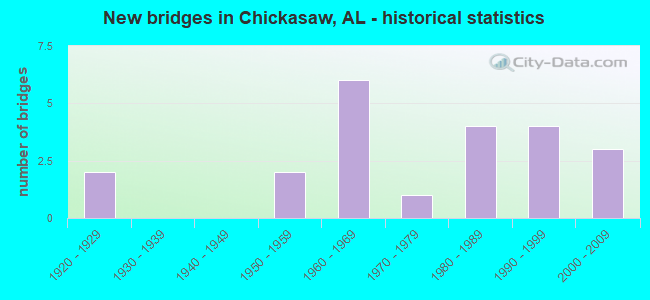
- New bridges - historical statistics
- 21920-1929
- 21950-1959
- 61960-1969
- 11970-1979
- 41980-1989
- 41990-1999
- 32000-2009

- Reconstructed bridges - Historical Statistics
- 41980-1989
- 01990-1999
- 12000-2009


- Bridge Condition - Deck
- 25.0%Good
- 41.7%Satisfactory
- 25.0%Fair
- 8.3%Poor

- Bridge Condition - Superstructure
- 8.3%Very good
- 33.3%Good
- 16.7%Satisfactory
- 33.3%Fair
- 8.3%Serious

- Bridge Condition - Substructure
- 33.3%Good
- 33.3%Satisfactory
- 16.7%Fair
- 8.3%Poor
- 8.3%Serious

- Bridge Condition - Channel
- 40.0%Good
- 40.0%Satisfactory
- 20.0%Fair

- Bridge Condition - Culverts
- 14.3%Good
- 71.4%Satisfactory
- 14.3%Fair
Find on map >> Show street view
Structure Number: 152, Location: 0.7 MI.N.OF US 331 (Lat: 32.307431, Lng: -86.299678), Route carried "on" structure: County highway 277, Year Built: 1920, Status: Closed, Structure Length: 39.26m (128.81ft), Average Daily Traffic: 3,320 (year 1990), Truck Traffic: 5%, Average Future Daily Traffic: 5,580 (year 2025), Design Load: H 15, Features Intersected: CATOMA CREEK, Facility Carried by Structure: NORMAN BRIDGE RD.
Minimum Vertical Clearance: 30+ m (98+ ft), Kilometerpoint: 0.698, Lanes on structure: 2, Owner: City or Municipal Highway Agency, Approaching Roadway Width: 9.8m (32.2ft), Material/Design: Concrete continuous, Design/Construction: Tee Beam, Number Of Spans In Main Unit: 3, Number Of Approach Spans: 53, Length of Maximum Span: 18.3m (60.0ft), Curb-To-Curb Width: 6.1m (20.0ft), Out-to-Out Width: 6.9m (22.6ft)
Condition: Deck: Poor, Superstructure: Serious, Substructure: Serious, Channel: Fair, Waterway Adequacy: Equal to present minimum criteria, Approach Roadway Alignment: Equal to present minimum criteria, Bridge Posting: Required (Relationship of Operating Rating to Maximum Legal Load: > 39.9% below), Length Of Structure Improvement: 39.26m (128.81ft), Designated Inspection Frequency: Every 24 months, Other Special Inspection Frequency: Every 12 months, Inspection Date: December 2003, Other Special Inspection Date: December 2004, Bridge Improvement Cost: $5,923,000, Roadway Improvement Cost: $592,000, Total Project Cost: $6,515,000 ( Estimate for 2022), Deck Structure Type: Concrete Cast-file-Place, Wearing Surface/Protective System: Wearing Surface: Bituminous
Find on map >> Show street view
Structure Number: 4251, Location: .1 MI. N.E. HWY. 17 (Lat: 33.925169, Lng: -88.146853), Route carried "on" structure: County highway 35, Year Built: 1952, Status: Open, Structure Length: 1.62m (5.31ft), Average Daily Traffic: 490 (year 2016), Truck Traffic: 4%, Average Future Daily Traffic: 728 (year 2036), Design Load: H 15, Features Intersected: PINE SPRINGS CREEK, Facility Carried by Structure: RIVER RD
Minimum Vertical Clearance: 30+ m (98+ ft), Kilometerpoint: 0.010, Lanes on structure: 2, Owner: County Highway Agency, Approaching Roadway Width: 7.9m (25.9ft), Material/Design: Concrete, Design/Construction: Culvert, Number Of Spans In Main Unit: 5, Length of Maximum Span: 3.0m (9.8ft)
Condition: Channel: Fair, Culverts: Satisfactory, Operating Rating: 39.1 metric tons, Method Used To Determine Operating Rating: Load Factor (LF), Inventory Rating: 23.5 metric tons, Method Used To Determine Inventory Rating: Load Factor (LF), Structural Evaluation: Equal to present minimum criteria, Waterway Adequacy: Equal to present minimum criteria, Approach Roadway Alignment: Equal to present desirable criteria, Length Of Structure Improvement: 2.30m (7.55ft), Designated Inspection Frequency: Every 24 months, Inspection Date: November 2020, Bridge Improvement Cost: $426,000, Roadway Improvement Cost: $43,000, Total Project Cost: $469,000 ( Estimate for 2022), Wearing Surface/Protective System: Wearing Surface: Bituminous
Find on map >> Show street view
Structure Number: 6175, Location: 3 MI E OF LOCUST FORK (Lat: 33.884075, Lng: -86.581344), Route carried "on" structure: County highway 15, Year Built: 1958, Status: Open, Structure Length: 0.61m (2.00ft), Average Daily Traffic: 786 (year 2020), Truck Traffic: 7%, Average Future Daily Traffic: 1,167 (year 2040), Design Load: H 15, Features Intersected: SAND VALLEY CREEK
Minimum Vertical Clearance: 30+ m (98+ ft), Kilometerpoint: 0.010, Lanes on structure: 2, Owner: County Highway Agency, Approaching Roadway Width: 9.1m (29.9ft), Material/Design: Concrete, Design/Construction: Culvert, Number Of Spans In Main Unit: 2, Length of Maximum Span: 3.0m (9.8ft)
Condition: Channel: Fair, Culverts: Satisfactory, Operating Rating: 88.9 metric tons, Method Used To Determine Operating Rating: Load Factor (LF), Inventory Rating: 53.9 metric tons, Method Used To Determine Inventory Rating: Load Factor (LF), Structural Evaluation: Equal to present minimum criteria, Waterway Adequacy: Equal to present desirable criteria, Approach Roadway Alignment: Better than present minimum criteria, Length Of Structure Improvement: 1.22m (4.00ft), Designated Inspection Frequency: Every 24 months, Inspection Date: October 2020, Bridge Improvement Cost: $211,000, Roadway Improvement Cost: $21,000, Total Project Cost: $232,000 ( Estimate for 2022)
Find on map >> Show street view
Structure Number: 7116, Location: 1.5 MI N CO RT 67 T5SR7E (Lat: 34.561872, Lng: -85.880417), Route carried "on" structure: County highway 102, Year Built: 1960, Status: Open, Structure Length: 0.99m (3.25ft), Average Daily Traffic: 310 (year 2020), Truck Traffic: 5%, Average Future Daily Traffic: 461 (year 2040), Design Load: H 15, Features Intersected: STRAIGHT CREEK
Minimum Vertical Clearance: 30+ m (98+ ft), Kilometerpoint: 0.010, Lanes on structure: 2, Owner: County Highway Agency, Approaching Roadway Width: 10.5m (34.4ft), Skew: 1 degrees, Material/Design: Concrete, Design/Construction: Culvert, Number Of Spans In Main Unit: 3, Length of Maximum Span: 3.0m (9.8ft)
Condition: Channel: Satisfactory, Culverts: Satisfactory, Operating Rating: 53.6 metric tons, Method Used To Determine Operating Rating: Load Factor (LF), Inventory Rating: 32.2 metric tons, Method Used To Determine Inventory Rating: Load Factor (LF), Structural Evaluation: Equal to present minimum criteria, Waterway Adequacy: Better than present minimum criteria, Approach Roadway Alignment: Equal to present desirable criteria, Length Of Structure Improvement: 1.66m (5.45ft), Designated Inspection Frequency: Every 24 months, Inspection Date: March 2021, Bridge Improvement Cost: $499,000, Roadway Improvement Cost: $50,000, Total Project Cost: $549,000 ( Estimate for 2022), Wearing Surface/Protective System: Wearing Surface: Bituminous
Find on map >> Show street view
Structure Number: 858, Location: 1.3 MI N SR 45 (Lat: 30.763358, Lng: -88.093108), Route carried "on" structure: City street , Year Built: 1965, Status: Open, Structure Length: 8.11m (26.61ft), Average Daily Traffic: 1,452 (year 2018), Truck Traffic: 1%, Average Future Daily Traffic: 2,178 (year 2038), Design Load: HS 20, Features Intersected: I65, Facility Carried by Structure: THOMPSON BLVD
Minimum Vertical Clearance: 30+ m (98+ ft), Kilometerpoint: 0.000, Lanes on structure: 2, Lanes under structure: 6, Owner: State Highway Agency, Approaching Roadway Width: 8.5m (27.9ft), Skew: 1 degrees, Material/Design: Concrete continuous, Design/Construction: Tee Beam, Number Of Spans In Main Unit: 4, Length of Maximum Span: 22.3m (73.2ft), Curb or Sidewalk Widths: Left: 1.5m (4.9ft), Right: 1.5m (4.9ft), Curb-To-Curb Width: 8.5m (27.9ft), Out-to-Out Width: 12.3m (40.4ft)
Condition: Deck: Fair, Superstructure: Fair, Substructure: Fair, Operating Rating: 48.3 metric tons, Method Used To Determine Operating Rating: Load Factor (LF), Inventory Rating: 28.9 metric tons, Method Used To Determine Inventory Rating: Load Factor (LF), Structural Evaluation: Somewhat better than minimum adequacy, Deck Geometry: Somewhat better than minimum adequacy, Underclear: High priority of corrective action, Approach Roadway Alignment: Better than present minimum criteria, Length Of Structure Improvement: 9.11m (29.89ft), Designated Inspection Frequency: Every 24 months, Inspection Date: May 2020, Bridge Improvement Cost: $2,499,000, Roadway Improvement Cost: $250,000, Total Project Cost: $2,749,000 ( Estimate for 2022), Deck Structure Type: Concrete Cast-file-Place
Find on map >> Show street view
Structure Number: 9272, Location: 1.1 MI N CELESTE ROAD (Lat: 30.842275, Lng: -88.079350), Route carried "on" structure: Interstate 65, Year Built: 1967, Status: Open, Structure Length: 2.68m (8.79ft), Average Daily Traffic: 51,074 (year 2018), Truck Traffic: 10%, Average Future Daily Traffic: 76,611 (year 2038), Design Load: HS 20, Features Intersected: HELLS SWAMP CREEK
Minimum Vertical Clearance: 30+ m (98+ ft), Kilometerpoint: 26.133, Lanes on structure: 4, Base Highway Network: Yes, Owner: State Highway Agency, Approaching Roadway Width: 36.0m (118.1ft), Skew: 14 degrees, Material/Design: Concrete, Design/Construction: Culvert, Number Of Spans In Main Unit: 5, Length of Maximum Span: 3.7m (12.1ft)
Condition: Channel: Satisfactory, Culverts: Fair, Operating Rating: 54.4 metric tons, Method Used To Determine Operating Rating: Load Factor (LF), Inventory Rating: 32.9 metric tons, Method Used To Determine Inventory Rating: Load Factor (LF), Structural Evaluation: Somewhat better than minimum adequacy, Waterway Adequacy: Equal to present desirable criteria, Approach Roadway Alignment: Superior to present desirable criteria, Length Of Structure Improvement: 3.59m (11.78ft), Designated Inspection Frequency: Every 24 months, Other Special Inspection Frequency: Every 12 months, Inspection Date: March 2020, Other Special Inspection Date: March 2021, Bridge Improvement Cost: $4,584,000, Roadway Improvement Cost: $458,000, Total Project Cost: $5,042,000 ( Estimate for 2022)
Find on map >> Show street view
Structure Number: 12285, Location: 0.37 MI N ALPINE ST (Lat: 30.781372, Lng: -88.086928), Route carried "on" structure: City street , Year Built: 1960, Year Reconstructed: 1980, Status: Open, Structure Length: 2.26m (7.41ft), Average Daily Traffic: 160 (year 2021), Truck Traffic: 10%, Average Future Daily Traffic: 250 (year 2041), Design Load: HS 20, Features Intersected: BAYOU BARATARA, Facility Carried by Structure: BARATARA DRIVE
Minimum Vertical Clearance: 30+ m (98+ ft), Kilometerpoint: 0.369, Lanes on structure: 2, Owner: City or Municipal Highway Agency, Approaching Roadway Width: 6.6m (21.7ft), Material/Design: Concrete, Design/Construction: Channel Beam, Number Of Spans In Main Unit: 3, Length of Maximum Span: 7.3m (24.0ft), Curb or Sidewalk Widths: Left: 0.9m (3.0ft), Right: 0.9m (3.0ft), Curb-To-Curb Width: 8.9m (29.2ft), Out-to-Out Width: 11.9m (39.0ft)
Condition: Deck: Satisfactory, Superstructure: Satisfactory, Substructure: Satisfactory, Channel: Good, Operating Rating: 53.3 metric tons, Method Used To Determine Operating Rating: Load Factor (LF), Inventory Rating: 31.9 metric tons, Method Used To Determine Inventory Rating: Load Factor (LF), Structural Evaluation: Equal to present minimum criteria, Deck Geometry: Equal to present minimum criteria, Waterway Adequacy: Better than present minimum criteria, Approach Roadway Alignment: Better than present minimum criteria, Length Of Structure Improvement: 3.07m (10.07ft), Designated Inspection Frequency: Every 24 months, Underwater Inspection Frequency: Every 24 months, Inspection Date: September 2021, Underwater Inspection Date: September 2021, Bridge Improvement Cost: $801,000, Roadway Improvement Cost: $80,000, Total Project Cost: $881,000 ( Estimate for 2022), Deck Structure Type: Concrete Precast Panels
Find on map >> Show street view
Structure Number: 1232, Location: 2.1 MI N US 45 (Lat: 30.767067, Lng: -88.094236), Route carried "on" structure: City street , Year Built: 1980, Status: Open, Structure Length: 8.10m (26.57ft), Average Daily Traffic: 4,287 (year 2018), Truck Traffic: 2%, Average Future Daily Traffic: 6,431 (year 2038), Design Load: HS 20, Features Intersected: I65, Facility Carried by Structure: WEST LEE ST
Minimum Vertical Clearance: 30+ m (98+ ft), Kilometerpoint: 17.004, Lanes on structure: 5, Lanes under structure: 6, Owner: State Highway Agency, Approaching Roadway Width: 26.2m (86.0ft), Skew: 21 degrees, Material/Design: Steel continuous, Design/Construction: Stringer/Multi-beam, Number Of Spans In Main Unit: 4, Length of Maximum Span: 22.3m (73.2ft), Curb or Sidewalk Widths: Left: 1.5m (4.9ft), Right: 1.5m (4.9ft), Curb-To-Curb Width: 22.6m (74.1ft), Out-to-Out Width: 26.5m (86.9ft)
Condition: Deck: Satisfactory, Superstructure: Good, Substructure: Good, Operating Rating: 56.0 metric tons, Method Used To Determine Operating Rating: Load Factor (LF), Inventory Rating: 33.5 metric tons, Method Used To Determine Inventory Rating: Load Factor (LF), Structural Evaluation: Better than present minimum criteria, Deck Geometry: Equal to present minimum criteria, Underclear: Meets minimum limits, Approach Roadway Alignment: Better than present minimum criteria, Length Of Structure Improvement: 9.11m (29.89ft), Designated Inspection Frequency: Every 24 months, Inspection Date: June 2020, Bridge Improvement Cost: $5,370,000, Roadway Improvement Cost: $537,000, Total Project Cost: $5,907,000 ( Estimate for 2022), Deck Structure Type: Concrete Cast-file-Place
Find on map >> Show street view
Structure Number: 13906, Location: 0.9 MI S SR 158 (Lat: 30.781825, Lng: -88.072764), Route carried "on" structure: US 43, Year Built: 1986, Status: Open, Structure Length: 14.97m (49.11ft), Average Daily Traffic: 14,103 (year 2018), Truck Traffic: 5%, Average Future Daily Traffic: 21,155 (year 2038), Design Load: HS 20, Features Intersected: CHICKASABOGUE CREEK
Minimum Vertical Clearance: 30+ m (98+ ft), Kilometerpoint: 5.845, Lanes on structure: 4, Owner: State Highway Agency, Approaching Roadway Width: 23.1m (75.8ft), Skew: 20 degrees, Material/Design: Steel, Design/Construction: Stringer/Multi-beam, Number Of Spans In Main Unit: 1, Number Of Approach Spans: 10, Length of Maximum Span: 24.7m (81.0ft), Curb-To-Curb Width: 23.1m (75.8ft), Out-to-Out Width: 25.2m (82.7ft)
Condition: Deck: Satisfactory, Superstructure: Fair, Substructure: Satisfactory, Channel: Good, Operating Rating: 56.9 metric tons, Method Used To Determine Operating Rating: Load Factor (LF), Inventory Rating: 33.3 metric tons, Method Used To Determine Inventory Rating: Load Factor (LF), Structural Evaluation: Somewhat better than minimum adequacy, Deck Geometry: Superior to present desirable criteria, Waterway Adequacy: Equal to present minimum criteria, Approach Roadway Alignment: Equal to present desirable criteria, Length Of Structure Improvement: 15.74m (51.64ft), Designated Inspection Frequency: Every 24 months, Underwater Inspection Frequency: Every 24 months, Inspection Date: July 2020, Underwater Inspection Date: November 2020, Bridge Improvement Cost: $8,850,000, Roadway Improvement Cost: $885,000, Total Project Cost: $9,735,000 ( Estimate for 2022), Deck Structure Type: Concrete Cast-file-Place
Find on map >> Show street view
Structure Number: 14324, Location: Beaverton (Lat: 33.928833, Lng: -88.024383), Route carried "on" structure: US 278, Year Built: 1926, Year Reconstructed: 1988, Status: Open, Structure Length: 0.64m (2.10ft), Average Daily Traffic: 2,323 (year 2020), Truck Traffic: 13%, Average Future Daily Traffic: 3,716 (year 2040), Design Load: H 15, Features Intersected: Branch, Facility Carried by Structure: AL-118
Minimum Vertical Clearance: 30+ m (98+ ft), Kilometerpoint: 20.106, Lanes on structure: 2, Base Highway Network: Yes, Owner: State Highway Agency, Approaching Roadway Width: 10.4m (34.1ft), Material/Design: Concrete, Design/Construction: Culvert, Number Of Spans In Main Unit: 2, Length of Maximum Span: 3.0m (9.8ft)
Condition: Channel: Satisfactory, Culverts: Satisfactory, Operating Rating: 78.3 metric tons, Method Used To Determine Operating Rating: Load Factor (LF), Inventory Rating: 46.9 metric tons, Method Used To Determine Inventory Rating: Load Factor (LF), Structural Evaluation: Equal to present minimum criteria, Waterway Adequacy: Equal to present minimum criteria, Approach Roadway Alignment: Equal to present desirable criteria, Length Of Structure Improvement: 1.26m (4.13ft), Designated Inspection Frequency: Every 24 months, Inspection Date: November 2020, Bridge Improvement Cost: $320,000, Roadway Improvement Cost: $32,000, Total Project Cost: $352,000 ( Estimate for 2022)
Find on map >> Show street view
Structure Number: 14467, Location: 1.3 MI N OF I65 (Lat: 32.367914, Lng: -86.300072), Route carried "on" structure: Interstate 85, Year Built: 1970, Year Reconstructed: 1988, Status: Open, Structure Length: 5.15m (16.90ft), Average Daily Traffic: 83,530 (year 2013), Truck Traffic: 13%, Average Future Daily Traffic: 110,089 (year 2033), Design Load: HS 20, Features Intersected: UNION ST
Minimum Vertical Clearance: 30+ m (98+ ft), Kilometerpoint: 2.221, Lanes on structure: 6, Lanes under structure: 4, Base Highway Network: Yes, Owner: State Highway Agency, Approaching Roadway Width: 36.6m (120.1ft), Skew: 30 degrees, Material/Design: Concrete continuous, Design/Construction: Tee Beam, Number Of Spans In Main Unit: 3, Length of Maximum Span: 19.5m (64.0ft), Curb-To-Curb Width: 32.0m (105.0ft), Out-to-Out Width: 33.8m (110.9ft)
Condition: Deck: Fair, Superstructure: Satisfactory, Substructure: Satisfactory, Operating Rating: 55.0 metric tons, Method Used To Determine Operating Rating: Load Factor (LF), Inventory Rating: 32.7 metric tons, Method Used To Determine Inventory Rating: Load Factor (LF), Structural Evaluation: Equal to present minimum criteria, Deck Geometry: Superior to present desirable criteria, Underclear: Somewhat better than minimum adequacy, Approach Roadway Alignment: Better than present minimum criteria, Length Of Structure Improvement: 6.17m (20.24ft), Designated Inspection Frequency: Every 24 months, Inspection Date: June 2021, Bridge Improvement Cost: $4,657,000, Roadway Improvement Cost: $466,000, Total Project Cost: $5,123,000 ( Estimate for 2022), Deck Structure Type: Concrete Cast-file-Place
Find on map >> Show street view
Structure Number: 14476, Location: TURKEY CREEK RD. (Lat: 31.759175, Lng: -86.212331), Route carried "on" structure: County highway , Year Built: 1988, Status: Open, Structure Length: 0.94m (3.08ft), Average Daily Traffic: 80 (year 1993), Average Future Daily Traffic: 88 (year 2033), Design Load: HS 20, Features Intersected: BEAR CREEK, Facility Carried by Structure: TURKEY CREEK RD.
Minimum Vertical Clearance: 30+ m (98+ ft), Kilometerpoint: 0.010, Lanes on structure: 2, Owner: County Highway Agency, Approaching Roadway Width: 9.8m (32.2ft), Material/Design: Concrete, Design/Construction: Culvert, Number Of Spans In Main Unit: 2, Length of Maximum Span: 4.3m (14.1ft), Curb-To-Curb Width: 6.7m (22.0ft), Out-to-Out Width: 9.8m (32.2ft)
Condition: Channel: Good, Culverts: Good, Operating Rating: 70.1 metric tons, Method Used To Determine Operating Rating: Load Factor (LF), Inventory Rating: 42.1 metric tons, Method Used To Determine Inventory Rating: Load Factor (LF), Structural Evaluation: Better than present minimum criteria, Deck Geometry: Somewhat better than minimum adequacy, Waterway Adequacy: Better than present minimum criteria, Approach Roadway Alignment: Equal to present minimum criteria, Length Of Structure Improvement: 1.61m (5.28ft), Designated Inspection Frequency: Every 24 months, Inspection Date: July 2021, Bridge Improvement Cost: $297,000, Roadway Improvement Cost: $30,000, Total Project Cost: $327,000 ( Estimate for 2022)
Find on map >> Show street view
Structure Number: 15161, Location: 2.84 MILES NW OF CR-14 (Lat: 32.827600, Lng: -86.165264), Route carried "on" structure: County highway 18, Year Built: 1991, Status: Open, Structure Length: 1.78m (5.84ft), Average Daily Traffic: 152 (year 2020), Truck Traffic: 3%, Average Future Daily Traffic: 226 (year 2040), Design Load: HS 20, Features Intersected: Swamp Creek
Minimum Vertical Clearance: 30+ m (98+ ft), Kilometerpoint: 0.010, Lanes on structure: 1, Owner: County Highway Agency, Approaching Roadway Width: 5.5m (18.0ft), Material/Design: Concrete, Design/Construction: Culvert, Number Of Spans In Main Unit: 4, Length of Maximum Span: 4.3m (14.1ft)
Condition: Channel: Satisfactory, Culverts: Satisfactory, Operating Rating: 63.0 metric tons, Method Used To Determine Operating Rating: Load Factor (LF), Inventory Rating: 52.5 metric tons, Method Used To Determine Inventory Rating: Load Factor (LF), Structural Evaluation: Equal to present minimum criteria, Waterway Adequacy: Equal to present minimum criteria, Approach Roadway Alignment: Better than present minimum criteria, Length Of Structure Improvement: 2.48m (8.14ft), Designated Inspection Frequency: Every 24 months, Inspection Date: March 2020, Bridge Improvement Cost: $716,000, Roadway Improvement Cost: $72,000, Total Project Cost: $788,000 ( Estimate for 2022)
Find on map >> Show street view
Structure Number: 15263, Location: 1.3MI. SW CO.RT.17 (Lat: 32.184369, Lng: -87.927436), Route carried "on" structure: County highway 462, Year Built: 1990, Status: Posted for load, Structure Length: 0.82m (2.69ft), Average Daily Traffic: 50 (year 1990), Average Future Daily Traffic: 70 (year 2042), Design Load: H 10, Features Intersected: LITTLE BEAVER CRK
Minimum Vertical Clearance: 30+ m (98+ ft), Kilometerpoint: 0.000, Lanes on structure: 2, Owner: County Highway Agency, Approaching Roadway Width: 7.3m (24.0ft), Material/Design: Steel, Design/Construction: Stringer/Multi-beam, Number Of Spans In Main Unit: 1, Length of Maximum Span: 8.2m (26.9ft), Curb-To-Curb Width: 6.7m (22.0ft), Out-to-Out Width: 6.7m (22.0ft)
Condition: Deck: Satisfactory, Superstructure: Fair, Substructure: Poor, Channel: Satisfactory, Operating Rating: 2.7 metric tons, Method Used To Determine Operating Rating: Load Factor (LF), Inventory Rating: 1.8 metric tons, Method Used To Determine Inventory Rating: Load Factor (LF), Structural Evaluation: High priority of replacement, Deck Geometry: Somewhat better than minimum adequacy, Waterway Adequacy: Better than present minimum criteria, Approach Roadway Alignment: Somewhat better than minimum adequacy, Bridge Posting: Required (Relationship of Operating Rating to Maximum Legal Load: > 39.9% below), Length Of Structure Improvement: 1.48m (4.86ft), Designated Inspection Frequency: Every 24 months, Other Special Inspection Frequency: Every 12 months, Inspection Date: Febuary 2022, Other Special Inspection Date: Febuary 2022, Bridge Improvement Cost: $223,000, Roadway Improvement Cost: $22,000, Total Project Cost: $245,000 ( Estimate for 2022), Deck Structure Type: Wood or Timber, Wearing Surface/Protective System: Wearing Surface: Wood or Timber
Find on map >> Show street view
Structure Number: 15505, Location: 2.74 MI N US 45 (Lat: 30.771986, Lng: -88.095372), Route carried "on" structure: Interstate 65, Year Built: 1965, Year Reconstructed: 1992, Status: Open, Structure Length: 8.29m (27.20ft), Average Daily Traffic: 71,118 (year 2018), Truck Traffic: 11%, Average Future Daily Traffic: 106,677 (year 2038), Design Load: HS 20, Features Intersected: EIGHTMILE CREEK
Minimum Vertical Clearance: 30+ m (98+ ft), Kilometerpoint: 17.589, Lanes on structure: 6, Base Highway Network: Yes, Owner: State Highway Agency, Approaching Roadway Width: 39.9m (130.9ft), Skew: 34 degrees, Material/Design: Concrete, Design/Construction: Tee Beam, Number Of Spans In Main Unit: 8, Length of Maximum Span: 10.4m (34.1ft), Curb-To-Curb Width: 40.0m (131.2ft), Out-to-Out Width: 41.9m (137.5ft)
Condition: Deck: Fair, Superstructure: Fair, Substructure: Fair, Channel: Satisfactory, Operating Rating: 39.9 metric tons, Method Used To Determine Operating Rating: Load Factor (LF), Inventory Rating: 23.9 metric tons, Method Used To Determine Inventory Rating: Load Factor (LF), Structural Evaluation: Somewhat better than minimum adequacy, Deck Geometry: Superior to present desirable criteria, Waterway Adequacy: Equal to present desirable criteria, Approach Roadway Alignment: Equal to present desirable criteria, Length Of Structure Improvement: 9.29m (30.48ft), Designated Inspection Frequency: Every 24 months, Underwater Inspection Frequency: Every 24 months, Inspection Date: May 2020, Underwater Inspection Date: August 2020, Bridge Improvement Cost: $8,725,000, Roadway Improvement Cost: $873,000, Total Project Cost: $9,598,000 ( Estimate for 2022), Deck Structure Type: Concrete Cast-file-Place
Find on map >> Show street view
Structure Number: 15539, Location: 0.1 MI S SR 213 (Lat: 30.762194, Lng: -88.125519), Route carried "on" structure: US 45, Year Built: 1992, Status: Open, Structure Length: 9.02m (29.59ft), Average Daily Traffic: 15,638 (year 2018), Truck Traffic: 3%, Average Future Daily Traffic: 23,457 (year 2038), Design Load: HS 20, Features Intersected: EIGHT MILE CREEK
Minimum Vertical Clearance: 7.56m (24.80ft), Kilometerpoint: 9.936, Lanes on structure: 4, Base Highway Network: Yes, Owner: State Highway Agency, Approaching Roadway Width: 16.4m (53.8ft), Material/Design: Prestressed concrete, Design/Construction: Box Beam or Girders - Multiple, Number Of Spans In Main Unit: 7, Length of Maximum Span: 15.2m (49.9ft), Curb or Sidewalk Widths: Left: 0.0m, Right: 2.3m (7.5ft), Curb-To-Curb Width: 16.4m (53.8ft), Out-to-Out Width: 19.7m (64.6ft)
Condition: Deck: Satisfactory, Superstructure: Good, Substructure: Good, Channel: Good, Operating Rating: 85.4 metric tons, Method Used To Determine Operating Rating: Load Factor (LF), Inventory Rating: 62.9 metric tons, Method Used To Determine Inventory Rating: Load Factor (LF), Structural Evaluation: Better than present minimum criteria, Deck Geometry: Meets minimum limits, Waterway Adequacy: Equal to present minimum criteria, Approach Roadway Alignment: Better than present minimum criteria, Length Of Structure Improvement: 9.99m (32.78ft), Designated Inspection Frequency: Every 24 months, Inspection Date: July 2020, Bridge Improvement Cost: $4,385,000, Roadway Improvement Cost: $439,000, Total Project Cost: $4,824,000 ( Estimate for 2022), Deck Structure Type: Concrete Cast-file-Place
Find on map >> Show street view
Structure Number: 1659, Location: 0.7 MI E US 43 (Lat: 30.764003, Lng: -88.063803), Route carried "on" structure: City street , Year Built: 1996, Year Reconstructed: 2011, Status: Open, Structure Length: 0.73m (2.40ft), Average Daily Traffic: 1,500 (year 2021), Truck Traffic: 50%, Average Future Daily Traffic: 1,650 (year 2041), Design Load: HS 20, Features Intersected: BRANCH FRM RESERVIOR, Facility Carried by Structure: VIADUCT RD
Minimum Vertical Clearance: 30+ m (98+ ft), Kilometerpoint: 0.698, Lanes on structure: 2, Owner: City or Municipal Highway Agency, Approaching Roadway Width: 11.9m (39.0ft), Material/Design: Concrete, Design/Construction: Channel Beam, Number Of Spans In Main Unit: 1, Length of Maximum Span: 7.3m (24.0ft), Curb-To-Curb Width: 12.9m (42.3ft), Out-to-Out Width: 12.9m (42.3ft)
Condition: Deck: Good, Superstructure: Good, Substructure: Satisfactory, Channel: Good, Operating Rating: 60.9 metric tons, Method Used To Determine Operating Rating: Load Factor (LF), Inventory Rating: 36.6 metric tons, Method Used To Determine Inventory Rating: Load Factor (LF), Structural Evaluation: Equal to present minimum criteria, Deck Geometry: Better than present minimum criteria, Waterway Adequacy: Equal to present desirable criteria, Approach Roadway Alignment: Equal to present desirable criteria, Length Of Structure Improvement: 1.38m (4.53ft), Designated Inspection Frequency: Every 24 months, Inspection Date: September 2021, Bridge Improvement Cost: $396,000, Roadway Improvement Cost: $40,000, Total Project Cost: $436,000 ( Estimate for 2022), Deck Structure Type: Concrete Precast Panels
Find on map >> Show street view
Structure Number: 17473, Location: 3.8 MI N US 45 (Lat: 30.786875, Lng: -88.100417), Route carried "on" structure: Interstate 65, Year Built: 2003, Status: Open, Structure Length: 17.34m (56.89ft), Average Daily Traffic: 71,118 (year 2018), Truck Traffic: 11%, Average Future Daily Traffic: 106,677 (year 2038), Design Load: HS 20, Features Intersected: CHICKASAW CREEK
Minimum Vertical Clearance: 30+ m (98+ ft), Kilometerpoint: 19.290, Lanes on structure: 6, Base Highway Network: Yes, Owner: State Highway Agency, Approaching Roadway Width: 9.1m (29.9ft), Material/Design: Prestressed concrete, Design/Construction: Stringer/Multi-beam, Number Of Spans In Main Unit: 3, Number Of Approach Spans: 12, Length of Maximum Span: 14.0m (45.9ft), Curb-To-Curb Width: 34.1m (111.9ft), Out-to-Out Width: 35.4m (116.1ft)
Condition: Deck: Good, Superstructure: Very good, Substructure: Good, Channel: Good, Operating Rating: 59.1 metric tons, Method Used To Determine Operating Rating: Load Factor (LF), Inventory Rating: 37.1 metric tons, Method Used To Determine Inventory Rating: Load Factor (LF), Structural Evaluation: Better than present minimum criteria, Deck Geometry: Superior to present desirable criteria, Waterway Adequacy: Equal to present minimum criteria, Approach Roadway Alignment: Better than present minimum criteria, Length Of Structure Improvement: 18.05m (59.22ft), Designated Inspection Frequency: Every 24 months, Underwater Inspection Frequency: Every 24 months, Inspection Date: May 2020, Underwater Inspection Date: June 2021, Bridge Improvement Cost: $14,359,000, Roadway Improvement Cost: $1,436,000, Total Project Cost: $15,795,000 ( Estimate for 2022), Deck Structure Type: Concrete Cast-file-Place
Find on map >> Show street view
Structure Number: 1825, Location: 0.2 MI E US 43 (Lat: 30.763886, Lng: -88.073283), Route carried "on" structure: City street , Year Built: 2001, Status: Open, Structure Length: 13.93m (45.70ft), Average Daily Traffic: 2,200 (year 2020), Truck Traffic: 10%, Average Future Daily Traffic: 3,064 (year 2040), Design Load: HS 20, Features Intersected: B-N * N-S RR SOUTH ST, Facility Carried by Structure: VIADUCT RD
Minimum Vertical Clearance: 30+ m (98+ ft), Kilometerpoint: 0.200, Lanes on structure: 2, Lanes under structure: 2, Owner: City or Municipal Highway Agency, Approaching Roadway Width: 10.1m (33.1ft), Material/Design: Steel continuous, Design/Construction: Stringer/Multi-beam, Number Of Spans In Main Unit: 6, Length of Maximum Span: 26.8m (87.9ft), Curb or Sidewalk Widths: Left: 1.5m (4.9ft), Right: 0.0m, Curb-To-Curb Width: 8.5m (27.9ft), Out-to-Out Width: 11.0m (36.1ft)
Condition: Deck: Good, Superstructure: Good, Substructure: Good, Operating Rating: 64.5 metric tons, Method Used To Determine Operating Rating: Load Factor (LF), Inventory Rating: 38.6 metric tons, Method Used To Determine Inventory Rating: Load Factor (LF), Structural Evaluation: Better than present minimum criteria, Deck Geometry: Meets minimum limits, Underclear: Better than present minimum criteria, Approach Roadway Alignment: Equal to present desirable criteria, Length Of Structure Improvement: 14.73m (48.33ft), Designated Inspection Frequency: Every 24 months, Inspection Date: June 2020, Bridge Improvement Cost: $3,636,000, Roadway Improvement Cost: $364,000, Total Project Cost: $4,000,000 ( Estimate for 2022), Deck Structure Type: Concrete Cast-file-Place
Find on map >> Show street view
Structure Number: 858, Location: 1.3 MI N SR 45 (Lat: 30.763358, Lng: -88.093108), Route carried "under" structure: Interstate 65, Year Built: 1965, Structure Length: 0. m, Average Daily Traffic: 70,680 (year 2018), Truck Traffic: 11%, Features Intersected: I65, Facility Carried by Structure: THOMPSON BLVD
Minimum Vertical Clearance: 5.11m (16.77ft), Kilometerpoint: 16.576, Lanes on structure: 2, Lanes under structure: 6, Material/Design: Concrete continuous, Design/Construction: Tee Beam, Length of Maximum Span: 22.3m (73.2ft)
Find on map >> Show street view
Structure Number: 1232, Location: 2.1 MI N US 45 (Lat: 30.767067, Lng: -88.094236), Route carried "under" structure: Interstate 65, Year Built: 1980, Structure Length: 0. m, Average Daily Traffic: 70,680 (year 2018), Truck Traffic: 11%, Features Intersected: I65, Facility Carried by Structure: WEST LEE ST
Minimum Vertical Clearance: 5.04m (16.54ft), Kilometerpoint: 17.003, Lanes on structure: 5, Lanes under structure: 6, Material/Design: Steel continuous, Design/Construction: Stringer/Multi-beam, Length of Maximum Span: 22.3m (73.2ft)
Find on map >> Show street view
Structure Number: 1825, Location: 0.2 MI E US 43 (Lat: 30.763886, Lng: -88.073283), Route carried "under" structure: Bypass City street , Year Built: 2001, Structure Length: 0. m, Average Daily Traffic: 50 (year 2020), Features Intersected: B-N * N-S RR SOUTH ST, Facility Carried by Structure: VIADUCT RD
Minimum Vertical Clearance: 4.79m (15.72ft), Kilometerpoint: 0.200, Lanes on structure: 2, Lanes under structure: 2, Material/Design: Steel continuous, Design/Construction: Stringer/Multi-beam, Length of Maximum Span: 26.8m (87.9ft)