Bridge Statistics for Cheyney University, Pennsylvania (PA)
Condition, Traffic, Stress, Structural Evaluation, Project Costs
- National Bridge Inventory (NBI) Statistics
- 17Number of bridges
- 89ft / 27.4mTotal length
- $2,193,000Total costs
- 81,759Total average daily traffic
- 4,243Total average daily truck traffic
- 109,527Total future (year 2022) average daily traffic
- National Bridge Inventory (NBI) Registered Bridges for Cheyney University
- No street view available for this location
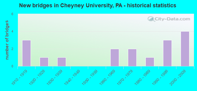
- New bridges - historical statistics
- 31910-1919
- 11920-1929
- 11930-1939
- 21960-1969
- 21970-1979
- 11980-1989
- 31990-1999
- 42000-2009

- Reconstructed bridges - Historical Statistics
- 11970-1979
- 11980-1989
- 11990-1999
- 22000-2009


- Bridge Condition - Deck
- 7.7%Very good
- 61.5%Good
- 15.4%Satisfactory
- 7.7%Fair
- 7.7%Poor

- Bridge Condition - Superstructure
- 31.3%Very good
- 37.5%Good
- 12.5%Satisfactory
- 6.3%Fair
- 6.3%Poor
- 6.3%Serious

- Bridge Condition - Substructure
- 12.5%Very good
- 37.5%Good
- 37.5%Satisfactory
- 6.3%Fair
- 6.3%Poor

- Bridge Condition - Channel
- 6.3%Very good
- 6.3%Good
- 18.8%Satisfactory
- 50.0%Fair
- 18.8%Poor
Find on map >> Show street view
Structure Number: 9925, Location: NEAR WEST CHESTER 32K9 (Lat: 39.965556, Lng: -75.544664), Route carried "on" structure: State highway 3, Year Built: 1960, Year Reconstructed: 1982, Status: Open, Structure Length: 1.74m (5.71ft), Average Daily Traffic: 25,960 (year 2020), Truck Traffic: 6%, Average Future Daily Traffic: 34,646 (year 2032), Design Load: HS 20, Features Intersected: EAST BR.CHESTER CREEK, Facility Carried by Structure: WEST CHESTER PIKE
Minimum Vertical Clearance: 30+ m (98+ ft), Kilometerpoint: 5.924, Lanes on structure: 4, Base Highway Network: Yes, Owner: State Highway Agency, Approaching Roadway Width: 25.6m (84.0ft), Skew: 23 degrees, Material/Design: Prestressed concrete, Design/Construction: Box Beam or Girders - Single/Spread, Number Of Spans In Main Unit: 1, Length of Maximum Span: 16.8m (55.1ft), Curb or Sidewalk Widths: Left: 0.2m (0.7ft), Right: 0.2m (0.7ft), Curb-To-Curb Width: 21.3m (69.9ft), Out-to-Out Width: 22.6m (74.1ft)
Condition: Deck: Good, Superstructure: Good, Substructure: Satisfactory, Channel: Satisfactory, Operating Rating: 82.6 metric tons, Method Used To Determine Operating Rating: Load Factor (LF), Inventory Rating: 39.9 metric tons, Method Used To Determine Inventory Rating: Load Factor (LF), Structural Evaluation: Equal to present minimum criteria, Deck Geometry: Superior to present desirable criteria, Waterway Adequacy: Equal to present minimum criteria, Approach Roadway Alignment: Equal to present desirable criteria, Length Of Structure Improvement: 2.40m (7.87ft), Designated Inspection Frequency: Every 24 months, Inspection Date: July 2020, Deck Structure Type: Concrete Cast-file-Place, Wearing Surface/Protective System: Wearing Surface: Monolithic Concrete
Find on map >> Show street view
Structure Number: 10285, Location: NR.CONRAIL BRIDGE 41J03 (Lat: 39.931600, Lng: -75.550758), Route carried "on" structure: State highway 926, Year Built: 1911, Status: Open, Structure Length: 1.16m (3.81ft), Average Daily Traffic: 9,266 (year 2021), Truck Traffic: 5%, Average Future Daily Traffic: 11,469 (year 2032), Design Load: H 15, Features Intersected: BRANCH CHESTER CREEK, Facility Carried by Structure: STREET ROAD
Minimum Vertical Clearance: 30+ m (98+ ft), Kilometerpoint: 35.354, Lanes on structure: 2, Owner: State Highway Agency, Approaching Roadway Width: 11.0m (36.1ft), Material/Design: Masonry, Design/Construction: Arch - Deck, Number Of Spans In Main Unit: 1, Length of Maximum Span: 11.0m (36.1ft), Curb-To-Curb Width: 6.3m (20.7ft), Out-to-Out Width: 7.8m (25.6ft)
Condition: Superstructure: Fair, Substructure: Satisfactory, Channel: Good, Operating Rating: 52.6 metric tons, Method Used To Determine Operating Rating: Field evaluation and documented engineering judgment, Inventory Rating: 26.3 metric tons, Method Used To Determine Inventory Rating: Field evaluation and documented engineering judgment, Structural Evaluation: Somewhat better than minimum adequacy, Deck Geometry: High priority of replacement, Waterway Adequacy: Equal to present minimum criteria, Approach Roadway Alignment: Equal to present desirable criteria, Length Of Structure Improvement: 1.80m (5.91ft), Designated Inspection Frequency: Every 24 months, Inspection Date: April 2020, Bridge Improvement Cost: $11,000, Roadway Improvement Cost: $31,000, Total Project Cost: $144,000
Find on map >> Show street view
Structure Number: 10286, Location: WESTTOWN STATION 41J3 (Lat: 39.932097, Lng: -75.549597), Route carried "on" structure: State highway 926, Year Built: 1987, Status: Open, Structure Length: 1.16m (3.81ft), Average Daily Traffic: 9,266 (year 2021), Truck Traffic: 5%, Average Future Daily Traffic: 11,469 (year 2032), Design Load: HS 25 or greater, Features Intersected: WEST CHESTER RR (SEPTA), Facility Carried by Structure: STREET ROAD
Minimum Vertical Clearance: 30+ m (98+ ft), Kilometerpoint: 35.354, Lanes on structure: 2, Owner: Railroad, Approaching Roadway Width: 10.1m (33.1ft), Skew: 2 degrees, Material/Design: Prestressed concrete, Design/Construction: Box Beam or Girders - Multiple, Number Of Spans In Main Unit: 1, Length of Maximum Span: 11.3m (37.1ft), Curb or Sidewalk Widths: Left: 0.2m (0.7ft), Right: 0.2m (0.7ft), Curb-To-Curb Width: 9.9m (32.5ft), Out-to-Out Width: 10.8m (35.4ft)
Condition: Deck: Good, Superstructure: Good, Substructure: Good, Operating Rating: 80.7 metric tons, Method Used To Determine Operating Rating: Load Factor (LF), Inventory Rating: 42.6 metric tons, Method Used To Determine Inventory Rating: Load Factor (LF), Structural Evaluation: Better than present minimum criteria, Deck Geometry: Meets minimum limits, Underclear: High priority of corrective action, Approach Roadway Alignment: Better than present minimum criteria, Length Of Structure Improvement: 1.80m (5.91ft), Designated Inspection Frequency: Every 24 months, Inspection Date: December 2020, Deck Structure Type: Concrete Cast-file-Place, Wearing Surface/Protective System: Wearing Surface: Monolithic Concrete, Deck Protection: Epoxy Coated Reinforcing
Find on map >> Show street view
Structure Number: 10287, Location: WEST OF TR-352 41G11 (Lat: 39.936047, Lng: -75.541103), Route carried "on" structure: State highway 926, Year Built: 2004, Status: Open, Structure Length: 2.83m (9.28ft), Average Daily Traffic: 10,617 (year 2022), Truck Traffic: 5%, Average Future Daily Traffic: 14,541 (year 2032), Design Load: HL 93, Features Intersected: CHESTER CREEK, Facility Carried by Structure: STREET ROAD
Minimum Vertical Clearance: 30+ m (98+ ft), Kilometerpoint: 36.432, Lanes on structure: 2, Owner: State Highway Agency, Approaching Roadway Width: 12.2m (40.0ft), Material/Design: Prestressed concrete continuous, Design/Construction: Box Beam or Girders - Single/Spread, Number Of Spans In Main Unit: 2, Length of Maximum Span: 13.7m (44.9ft), Curb or Sidewalk Widths: Left: 0.2m (0.7ft), Right: 0.2m (0.7ft), Curb-To-Curb Width: 12.2m (40.0ft), Out-to-Out Width: 13.1m (43.0ft)
Condition: Deck: Good, Superstructure: Good, Substructure: Good, Channel: Satisfactory, Operating Rating: 66.2 metric tons, Method Used To Determine Operating Rating: Load Factor (LF), Inventory Rating: 39.9 metric tons, Method Used To Determine Inventory Rating: Load Factor (LF), Structural Evaluation: Better than present minimum criteria, Deck Geometry: Somewhat better than minimum adequacy, Waterway Adequacy: Equal to present minimum criteria, Approach Roadway Alignment: Equal to present desirable criteria, Length Of Structure Improvement: 3.20m (10.50ft), Designated Inspection Frequency: Every 24 months, Inspection Date: August 2020, Bridge Improvement Cost: $67,000, Roadway Improvement Cost: $197,000, Total Project Cost: $902,000, Deck Structure Type: Concrete Cast-file-Place, Wearing Surface/Protective System: Wearing Surface: Monolithic Concrete, Deck Protection: Epoxy Coated Reinforcing
Find on map >> Show street view
Structure Number: 10784, Location: 0.5 Mi N of PA-3 3584-C5 (Lat: 39.972883, Lng: -75.548731), Route carried "on" structure: City street , Year Built: 1920, Year Reconstructed: 2008, Status: Open, Structure Length: 0.64m (2.10ft), Average Daily Traffic: 1,575 (year 2015), Truck Traffic: 2%, Average Future Daily Traffic: 1,800 (year 2035), Features Intersected: TRIB TO CHESTER CREEK, Facility Carried by Structure: RESERVOIR ROAD
Minimum Vertical Clearance: 30+ m (98+ ft), Kilometerpoint: 0.000, Lanes on structure: 1, Owner: Town or Township Highway Agency, Approaching Roadway Width: 6.1m (20.0ft), Skew: 2 degrees, Material/Design: Concrete, Design/Construction: Slab, Number Of Spans In Main Unit: 1, Length of Maximum Span: 5.8m (19.0ft), Curb-To-Curb Width: 4.7m (15.4ft), Out-to-Out Width: 5.7m (18.7ft)
Condition: Deck: Very good, Superstructure: Very good, Substructure: Good, Channel: Fair, Operating Rating: 56.2 metric tons, Method Used To Determine Operating Rating: Field evaluation and documented engineering judgment, Inventory Rating: 33.6 metric tons, Method Used To Determine Inventory Rating: Field evaluation and documented engineering judgment, Structural Evaluation: Better than present minimum criteria, Deck Geometry: High priority of replacement, Waterway Adequacy: Equal to present minimum criteria, Approach Roadway Alignment: Equal to present minimum criteria, Length Of Structure Improvement: 0.80m (2.62ft), Designated Inspection Frequency: Every 24 months, Inspection Date: April 2020, Bridge Improvement Cost: $12,000, Roadway Improvement Cost: $36,000, Total Project Cost: $165,000, Deck Structure Type: Concrete Cast-file-Place, Wearing Surface/Protective System: Wearing Surface: Bituminous, Deck Protection: Epoxy Coated Reinforcing
Find on map >> Show street view
Structure Number: 10785, Location: 0.4 MI S SR 3, 3584-C7 (Lat: 39.960544, Lng: -75.545622), Route carried "on" structure: City street , Year Built: 1916, Year Reconstructed: 2004, Status: Open, Structure Length: 0.91m (2.99ft), Average Daily Traffic: 2,300 (year 2010), Truck Traffic: 2%, Average Future Daily Traffic: 2,700 (year 2030), Design Load: HS 20, Features Intersected: EAST BRANCH CHESTER CRK., Facility Carried by Structure: WESTTOWN WAY
Minimum Vertical Clearance: 30+ m (98+ ft), Kilometerpoint: 0.000, Lanes on structure: 2, Owner: Town or Township Highway Agency, Approaching Roadway Width: 6.1m (20.0ft), Skew: 2 degrees, Material/Design: Prestressed concrete, Design/Construction: Box Beam or Girders - Single/Spread, Number Of Spans In Main Unit: 1, Length of Maximum Span: 8.2m (26.9ft), Curb-To-Curb Width: 6.1m (20.0ft), Out-to-Out Width: 7.6m (24.9ft)
Condition: Deck: Good, Superstructure: Very good, Substructure: Satisfactory, Channel: Fair, Operating Rating: 78.0 metric tons, Method Used To Determine Operating Rating: Load Factor (LF), Inventory Rating: 47.2 metric tons, Method Used To Determine Inventory Rating: Load Factor (LF), Structural Evaluation: Equal to present minimum criteria, Deck Geometry: High priority of replacement, Waterway Adequacy: Meets minimum limits, Approach Roadway Alignment: Better than present minimum criteria, Length Of Structure Improvement: 0.90m (2.95ft), Designated Inspection Frequency: Every 24 months, Inspection Date: April 2020, Bridge Improvement Cost: $18,000, Roadway Improvement Cost: $52,000, Total Project Cost: $238,000, Deck Structure Type: Concrete Cast-file-Place, Wearing Surface/Protective System: Wearing Surface: Bituminous, Deck Protection: Epoxy Coated Reinforcing
Find on map >> Show street view
Structure Number: 10861, Location: .5 Mi N PA-3 3585-B5 (Lat: 39.972181, Lng: -75.492167), Route carried "on" structure: City street , Year Built: 1930, Year Reconstructed: 1993, Status: Posted for load, Structure Length: 1.31m (4.30ft), Average Daily Traffic: 500 (year 2015), Truck Traffic: 1%, Average Future Daily Traffic: 550 (year 2035), Design Load: H 20, Features Intersected: RIDLEY CREEK, Facility Carried by Structure: GARRETT MILL ROAD
Minimum Vertical Clearance: 30+ m (98+ ft), Kilometerpoint: 0.000, Lanes on structure: 1, Owner: Town or Township Highway Agency, Approaching Roadway Width: 4.6m (15.1ft), Material/Design: Steel, Design/Construction: Truss - Thru, Number Of Spans In Main Unit: 1, Length of Maximum Span: 12.8m (42.0ft), Curb-To-Curb Width: 4.0m (13.1ft), Out-to-Out Width: 4.4m (14.4ft)
Condition: Deck: Poor, Superstructure: Poor, Substructure: Fair, Channel: Fair, Operating Rating: 20.9 metric tons, Method Used To Determine Operating Rating: Load Factor (LF), Inventory Rating: 11.8 metric tons, Method Used To Determine Inventory Rating: Load Factor (LF), Structural Evaluation: Meets minimum limits, Deck Geometry: High priority of replacement, Waterway Adequacy: Equal to present desirable criteria, Approach Roadway Alignment: Meets minimum limits, Bridge Posting: Required (Relationship of Operating Rating to Maximum Legal Load: > 39.9% below), Length Of Structure Improvement: 1.60m (5.25ft), Designated Inspection Frequency: Every 24 months, Critical Feature Inspection Frequency: Every 12 months, Other Special Inspection Frequency: Every 12 months, Inspection Date: August 2019, Critical Feature Inspection Date: August 2020, Other Special Inspection Date: August 2020, Bridge Improvement Cost: $4,000, Roadway Improvement Cost: $31,000, Total Project Cost: $53,000, Deck Structure Type: Open Grating
Find on map >> Show street view
Structure Number: 15358, Location: CONCORD;THORNBURY 32A09 (Lat: 39.894719, Lng: -75.536444), Route carried "on" structure: State highway , Year Built: 1973, Status: Open, Structure Length: 1.04m (3.41ft), Average Daily Traffic: 984 (year 2021), Truck Traffic: 4%, Average Future Daily Traffic: 875 (year 2032), Design Load: HS 20, Features Intersected: WEST BRANCH CHESTER CR., Facility Carried by Structure: MILL ROAD
Minimum Vertical Clearance: 30+ m (98+ ft), Kilometerpoint: 0.000, Lanes on structure: 2, Owner: State Highway Agency, Approaching Roadway Width: 7.0m (23.0ft), Material/Design: Prestressed concrete, Design/Construction: Slab, Number Of Spans In Main Unit: 1, Length of Maximum Span: 9.8m (32.2ft), Curb or Sidewalk Widths: Left: 0.2m (0.7ft), Right: 0.2m (0.7ft), Curb-To-Curb Width: 8.7m (28.5ft), Out-to-Out Width: 9.9m (32.5ft)
Condition: Deck: Good, Superstructure: Good, Substructure: Good, Channel: Poor, Operating Rating: 84.4 metric tons, Method Used To Determine Operating Rating: Load Factor (LF), Inventory Rating: 47.2 metric tons, Method Used To Determine Inventory Rating: Load Factor (LF), Structural Evaluation: Better than present minimum criteria, Deck Geometry: Somewhat better than minimum adequacy, Waterway Adequacy: Better than present minimum criteria, Approach Roadway Alignment: Equal to present desirable criteria, Length Of Structure Improvement: 1.70m (5.58ft), Designated Inspection Frequency: Every 24 months, Inspection Date: November 2019, Deck Structure Type: Concrete Cast-file-Place, Wearing Surface/Protective System: Wearing Surface: Bituminous
Find on map >> Show street view
Structure Number: 15361, Location: 1MI.S.CHEYNEY COL. 32C03 (Lat: 39.929519, Lng: -75.523231), Route carried "on" structure: State highway , Year Built: 1991, Status: Open, Structure Length: 1.71m (5.61ft), Average Daily Traffic: 3,064 (year 2020), Truck Traffic: 5%, Average Future Daily Traffic: 6,430 (year 2032), Design Load: HS 25 or greater, Features Intersected: CHESTER CREEK, Facility Carried by Structure: CHEYNEY ROAD
Minimum Vertical Clearance: 30+ m (98+ ft), Kilometerpoint: 6.133, Lanes on structure: 2, Owner: State Highway Agency, Approaching Roadway Width: 8.8m (28.9ft), Material/Design: Prestressed concrete, Design/Construction: Box Beam or Girders - Multiple, Number Of Spans In Main Unit: 1, Length of Maximum Span: 16.8m (55.1ft), Curb or Sidewalk Widths: Left: 0.2m (0.7ft), Right: 0.2m (0.7ft), Curb-To-Curb Width: 8.9m (29.2ft), Out-to-Out Width: 9.9m (32.5ft)
Condition: Deck: Good, Superstructure: Satisfactory, Substructure: Satisfactory, Channel: Fair, Operating Rating: 97.1 metric tons, Method Used To Determine Operating Rating: Load Factor (LF), Inventory Rating: 42.6 metric tons, Method Used To Determine Inventory Rating: Load Factor (LF), Structural Evaluation: Equal to present minimum criteria, Deck Geometry: Meets minimum limits, Waterway Adequacy: Equal to present minimum criteria, Approach Roadway Alignment: Equal to present desirable criteria, Length Of Structure Improvement: 2.40m (7.87ft), Designated Inspection Frequency: Every 24 months, Inspection Date: December 2019, Deck Structure Type: Concrete Cast-file-Place, Wearing Surface/Protective System: Wearing Surface: Monolithic Concrete, Deck Protection: Epoxy Coated Reinforcing
Find on map >> Show street view
Structure Number: 15362, Location: 1MI.S.CHEYNEY COL. 32C03 (Lat: 39.929856, Lng: -75.523431), Route carried "on" structure: State highway , Year Built: 1991, Status: Open, Structure Length: 1.71m (5.61ft), Average Daily Traffic: 3,064 (year 2020), Truck Traffic: 5%, Average Future Daily Traffic: 6,430 (year 2032), Design Load: HS 25 or greater, Features Intersected: BR.CHESTER CK.(FLD.PLN.), Facility Carried by Structure: CHEYNEY ROAD
Minimum Vertical Clearance: 30+ m (98+ ft), Kilometerpoint: 6.133, Lanes on structure: 2, Owner: State Highway Agency, Approaching Roadway Width: 8.8m (28.9ft), Material/Design: Prestressed concrete, Design/Construction: Box Beam or Girders - Multiple, Number Of Spans In Main Unit: 1, Length of Maximum Span: 16.8m (55.1ft), Curb or Sidewalk Widths: Left: 0.2m (0.7ft), Right: 0.2m (0.7ft), Curb-To-Curb Width: 8.8m (28.9ft), Out-to-Out Width: 9.9m (32.5ft)
Condition: Deck: Satisfactory, Superstructure: Satisfactory, Substructure: Satisfactory, Channel: Satisfactory, Operating Rating: 97.1 metric tons, Method Used To Determine Operating Rating: Load Factor (LF), Inventory Rating: 42.6 metric tons, Method Used To Determine Inventory Rating: Load Factor (LF), Structural Evaluation: Equal to present minimum criteria, Deck Geometry: Meets minimum limits, Waterway Adequacy: Better than present minimum criteria, Approach Roadway Alignment: Equal to present desirable criteria, Length Of Structure Improvement: 2.40m (7.87ft), Designated Inspection Frequency: Every 24 months, Inspection Date: December 2019, Deck Structure Type: Concrete Cast-file-Place, Wearing Surface/Protective System: Wearing Surface: Monolithic Concrete, Deck Protection: Epoxy Coated Reinforcing
Find on map >> Show street view
Structure Number: 15366, Location: 1MI.N.US 1 32A09/3694-D7 (Lat: 39.895942, Lng: -75.538325), Route carried "on" structure: State highway , Year Built: 1969, Year Reconstructed: 2011, Status: Open, Structure Length: 1.01m (3.31ft), Average Daily Traffic: 7,663 (year 2022), Truck Traffic: 3%, Average Future Daily Traffic: 8,604 (year 2032), Design Load: HL 93, Features Intersected: WEST BR OF CHESTER CREEK, Facility Carried by Structure: BRINTON LAKE ROAD
Minimum Vertical Clearance: 30+ m (98+ ft), Kilometerpoint: 1.228, Lanes on structure: 2, Owner: State Highway Agency, Approaching Roadway Width: 6.4m (21.0ft), Skew: 1 degrees, Material/Design: Prestressed concrete, Design/Construction: Box Beam or Girders - Multiple, Number Of Spans In Main Unit: 1, Length of Maximum Span: 9.4m (30.8ft), Curb-To-Curb Width: 10.4m (34.1ft), Out-to-Out Width: 11.4m (37.4ft)
Condition: Deck: Good, Superstructure: Very good, Substructure: Satisfactory, Channel: Fair, Operating Rating: 53.5 metric tons, Method Used To Determine Operating Rating: Assigned ratings based on Load and Resistance Factor Design (LRFD) reported by rating factor (RF) using HL93 loadings, Inventory Rating: 33.7 metric tons, Method Used To Determine Inventory Rating: Assigned ratings based on Load and Resistance Factor Design (LRFD) reported by rating factor (RF) using HL93 loadings, Structural Evaluation: Equal to present minimum criteria, Deck Geometry: Meets minimum limits, Waterway Adequacy: Better than present minimum criteria, Approach Roadway Alignment: Equal to present desirable criteria, Length Of Structure Improvement: 1.60m (5.25ft), Designated Inspection Frequency: Every 24 months, Inspection Date: July 2021, Wearing Surface/Protective System: Wearing Surface: Monolithic Concrete, Deck Protection: Epoxy Coated Reinforcing
Find on map >> Show street view
Structure Number: 15385, Location: .8MI.SOUTH PA-926 17-D4 (Lat: 39.932697, Lng: -75.516933), Route carried "on" structure: County highway , Year Built: 1914, Status: Posted for load, Structure Length: 1.52m (4.99ft), Average Daily Traffic: 272 (year 2017), Truck Traffic: 6%, Average Future Daily Traffic: 340 (year 2032), Design Load: H 20, Features Intersected: CHESTER CREEK, Facility Carried by Structure: STATION ROAD
Minimum Vertical Clearance: 30+ m (98+ ft), Kilometerpoint: 0.000, Lanes on structure: 1, Owner: County Highway Agency, Approaching Roadway Width: 5.5m (18.0ft), Material/Design: Concrete, Design/Construction: Tee Beam, Number Of Spans In Main Unit: 1, Length of Maximum Span: 15.2m (49.9ft), Curb-To-Curb Width: 5.5m (18.0ft), Out-to-Out Width: 6.4m (21.0ft)
Condition: Deck: Fair, Superstructure: Serious, Substructure: Poor, Channel: Poor, Operating Rating: 6.4 metric tons, Method Used To Determine Operating Rating: Load Factor (LF), Inventory Rating: 3.6 metric tons, Method Used To Determine Inventory Rating: Load Factor (LF), Structural Evaluation: High priority of replacement, Deck Geometry: High priority of corrective action, Waterway Adequacy: Meets minimum limits, Approach Roadway Alignment: Better than present minimum criteria, Bridge Posting: Required (Relationship of Operating Rating to Maximum Legal Load: > 39.9% below), Length Of Structure Improvement: 2.90m (9.51ft), Designated Inspection Frequency: Every 24 months, Other Special Inspection Frequency: Every 12 months, Inspection Date: November 2019, Other Special Inspection Date: August 2021, Bridge Improvement Cost: $51,000, Roadway Improvement Cost: $151,000, Total Project Cost: $691,000, Deck Structure Type: Concrete Cast-file-Place, Wearing Surface/Protective System: Wearing Surface: Bituminous
Find on map >> Show street view
Structure Number: 40738, Location: WESTTOWN 41H2 (Lat: 39.934881, Lng: -75.558267), Route carried "on" structure: State highway , Year Built: 1999, Status: Open, Structure Length: 1.31m (4.30ft), Average Daily Traffic: 2,169 (year 2022), Truck Traffic: 5%, Average Future Daily Traffic: 2,397 (year 2035), Design Load: HS 25 or greater, Features Intersected: CHESTER CREEK, Facility Carried by Structure: WESTBOURNE ROAD
Minimum Vertical Clearance: 30+ m (98+ ft), Kilometerpoint: 3.257, Lanes on structure: 2, Owner: State Highway Agency, Approaching Roadway Width: 7.3m (24.0ft), Skew: 1 degrees, Material/Design: Prestressed concrete, Design/Construction: Box Beam or Girders - Multiple, Number Of Spans In Main Unit: 1, Length of Maximum Span: 12.8m (42.0ft), Curb or Sidewalk Widths: Left: 0.2m (0.7ft), Right: 0.2m (0.7ft), Curb-To-Curb Width: 10.0m (32.8ft), Out-to-Out Width: 11.1m (36.4ft)
Condition: Deck: Satisfactory, Superstructure: Very good, Substructure: Good, Channel: Poor, Operating Rating: 98.9 metric tons, Method Used To Determine Operating Rating: Load Factor (LF), Inventory Rating: 47.2 metric tons, Method Used To Determine Inventory Rating: Load Factor (LF), Structural Evaluation: Better than present minimum criteria, Deck Geometry: Meets minimum limits, Waterway Adequacy: Equal to present minimum criteria, Approach Roadway Alignment: Equal to present desirable criteria, Length Of Structure Improvement: 2.00m (6.56ft), Designated Inspection Frequency: Every 24 months, Inspection Date: January 2020, Deck Structure Type: Concrete Cast-file-Place, Wearing Surface/Protective System: Wearing Surface: Monolithic Concrete, Deck Protection: Epoxy Coated Reinforcing
Find on map >> Show street view
Structure Number: 42622, Location: WESTTOWN 32K12 (Lat: 39.952233, Lng: -75.548664), Route carried "on" structure: State highway , Year Built: 2004, Status: Open, Structure Length: 4.94m (16.21ft), Average Daily Traffic: 1,823 (year 2020), Truck Traffic: 9%, Average Future Daily Traffic: 3,926 (year 2032), Design Load: HS 25 or greater, Features Intersected: EAST BR CHESTER CREEK, Facility Carried by Structure: WESTTOWN ROAD
Minimum Vertical Clearance: 30+ m (98+ ft), Kilometerpoint: 3.613, Lanes on structure: 2, Owner: State Highway Agency, Approaching Roadway Width: 7.6m (24.9ft), Material/Design: Concrete, Design/Construction: Arch - Deck, Number Of Spans In Main Unit: 2, Length of Maximum Span: 12.8m (42.0ft), Curb-To-Curb Width: 7.9m (25.9ft), Out-to-Out Width: 8.7m (28.5ft)
Condition: Superstructure: Good, Substructure: Very good, Channel: Fair, Operating Rating: 57.2 metric tons, Method Used To Determine Operating Rating: Load Factor (LF), Inventory Rating: 40.8 metric tons, Method Used To Determine Inventory Rating: Load Factor (LF), Structural Evaluation: Better than present minimum criteria, Deck Geometry: Meets minimum limits, Waterway Adequacy: Equal to present desirable criteria, Approach Roadway Alignment: Equal to present desirable criteria, Length Of Structure Improvement: 3.70m (12.14ft), Designated Inspection Frequency: Every 24 months, Inspection Date: March 2021
Find on map >> Show street view
Structure Number: 4405, Location: THORNBURY TOWNSHIP 41K3 (Lat: 39.930706, Lng: -75.545386), Route carried "on" structure: State highway , Year Built: 2007, Status: Open, Structure Length: 1.55m (5.09ft), Average Daily Traffic: 2,419 (year 2022), Truck Traffic: 9%, Average Future Daily Traffic: 2,452 (year 2032), Design Load: H 15, Features Intersected: BRANCH CHESTER CREEK, Facility Carried by Structure: THORNTON ROAD
Minimum Vertical Clearance: 30+ m (98+ ft), Kilometerpoint: 1.384, Lanes on structure: 2, Owner: State Highway Agency, Approaching Roadway Width: 8.5m (27.9ft), Material/Design: Concrete, Design/Construction: Arch - Deck, Number Of Spans In Main Unit: 1, Length of Maximum Span: 14.6m (47.9ft), Curb-To-Curb Width: 8.5m (27.9ft), Out-to-Out Width: 9.8m (32.2ft)
Condition: Superstructure: Good, Substructure: Very good, Channel: Fair, Operating Rating: 85.3 metric tons, Method Used To Determine Operating Rating: Load Factor (LF), Inventory Rating: 60.8 metric tons, Method Used To Determine Inventory Rating: Load Factor (LF), Structural Evaluation: Better than present minimum criteria, Deck Geometry: Meets minimum limits, Waterway Adequacy: Better than present minimum criteria, Approach Roadway Alignment: Equal to present desirable criteria, Designated Inspection Frequency: Every 24 months, Inspection Date: June 2021
Find on map >> Show street view
Structure Number: 45266, Location: 2.5 Mi. SE PA-926 17-F5 (Lat: 39.931019, Lng: -75.504639), Route carried "on" structure: City street , Year Built: 2008, Status: Open, Structure Length: 2.23m (7.32ft), Average Daily Traffic: 617 (year 2017), Truck Traffic: 11%, Average Future Daily Traffic: 678 (year 2022), Design Load: HL 93, Features Intersected: CHESTER CREEK, Facility Carried by Structure: LOCKSLEY ROAD
Minimum Vertical Clearance: 30+ m (98+ ft), Kilometerpoint: 0.000, Lanes on structure: 2, Owner: County Highway Agency, Approaching Roadway Width: 6.7m (22.0ft), Material/Design: Prestressed concrete, Design/Construction: Box Beam or Girders - Single/Spread, Number Of Spans In Main Unit: 1, Length of Maximum Span: 21.6m (70.9ft), Curb or Sidewalk Widths: Left: 0.1m (0.3ft), Right: 0.1m (0.3ft), Curb-To-Curb Width: 8.5m (27.9ft), Out-to-Out Width: 9.6m (31.5ft)
Condition: Deck: Good, Superstructure: Very good, Substructure: Good, Channel: Very good, Operating Rating: 75.3 metric tons, Method Used To Determine Operating Rating: Load and Resistance Factor (LRFR), Inventory Rating: 41.7 metric tons, Method Used To Determine Inventory Rating: Load and Resistance Factor (LRFR), Structural Evaluation: Better than present minimum criteria, Deck Geometry: Somewhat better than minimum adequacy, Waterway Adequacy: Equal to present desirable criteria, Approach Roadway Alignment: Better than present minimum criteria, Designated Inspection Frequency: Every 24 months, Inspection Date: June 2020, Deck Structure Type: Concrete Cast-file-Place, Wearing Surface/Protective System: Wearing Surface: Monolithic Concrete, Deck Protection: Epoxy Coated Reinforcing
Find on map >> Show street view
Structure Number: 54889, Location: NE OF VALLEY RD (Lat: 39.957300, Lng: -75.487900), Route carried "on" structure: City street , Year Built: 1970, Status: Open, Structure Length: 0.67m (2.20ft), Average Daily Traffic: 200 (year 2018), Truck Traffic: 1%, Average Future Daily Traffic: 220 (year 2028), Design Load: HS 20, Features Intersected: BR. OF RIDLEY CREEK, Facility Carried by Structure: STACKHOUSE MILL RD
Minimum Vertical Clearance: 30+ m (98+ ft), Kilometerpoint: 0.000, Lanes on structure: 2, Owner: Town or Township Highway Agency, Approaching Roadway Width: 5.5m (18.0ft), Skew: 3 degrees, Material/Design: Steel, Design/Construction: Culvert, Number Of Spans In Main Unit: 2, Length of Maximum Span: 3.0m (9.8ft), Curb-To-Curb Width: 7.3m (24.0ft), Out-to-Out Width: 7.9m (25.9ft)
Condition: Channel: Fair, Culverts: Fair, Operating Rating: 49.0 metric tons, Method Used To Determine Operating Rating: Field evaluation and documented engineering judgment, Inventory Rating: 32.7 metric tons, Method Used To Determine Inventory Rating: Field evaluation and documented engineering judgment, Structural Evaluation: Somewhat better than minimum adequacy, Deck Geometry: Somewhat better than minimum adequacy, Waterway Adequacy: Equal to present minimum criteria, Approach Roadway Alignment: Equal to present desirable criteria, Designated Inspection Frequency: Every 24 months, Inspection Date: August 2020