Bridge Statistics for Chesterbrook, Pennsylvania (PA)
Condition, Traffic, Stress, Structural Evaluation, Project Costs
- National Bridge Inventory (NBI) Statistics
- 34Number of bridges
- 151ft / 46.1mTotal length
- $3,811,000Total costs
- 673,276Total average daily traffic
- 69,552Total average daily truck traffic
- National Bridge Inventory (NBI) Registered Bridges for Chesterbrook
- No street view available for this location
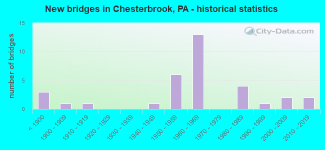
- New bridges - historical statistics
- 3Before 1900
- 11900-1909
- 11910-1919
- 11940-1949
- 61950-1959
- 131960-1969
- 41980-1989
- 11990-1999
- 22000-2009
- 22010-2019

- Reconstructed bridges - Historical Statistics
- 1Before 1900
- 01900-1909
- 01910-1919
- 01920-1929
- 01930-1939
- 01940-1949
- 11950-1959
- 01960-1969
- 01970-1979
- 01980-1989
- 21990-1999
- 22000-2009


- Bridge Condition - Deck
- 10.5%Very good
- 26.3%Good
- 47.4%Satisfactory
- 15.8%Fair

- Bridge Condition - Superstructure
- 15.0%Very good
- 20.0%Good
- 30.0%Satisfactory
- 35.0%Fair

- Bridge Condition - Substructure
- 5.0%Very good
- 25.0%Good
- 40.0%Satisfactory
- 15.0%Fair
- 5.0%Poor
- 10.0%Critical

- Bridge Condition - Channel
- 10.0%Very good
- 10.0%Satisfactory
- 50.0%Fair
- 30.0%Poor
Find on map >> Show street view
Structure Number: 10147, Location: PAOLI 24A05 (Lat: 40.062594, Lng: -75.474178), Route carried "on" structure: US 202, Year Built: 1966, Year Reconstructed: 2000, Status: Open, Structure Length: 1.34m (4.40ft), Average Daily Traffic: 68,158 (year 2022), Truck Traffic: 8%, Average Future Daily Traffic: 80,922 (year 2032), Design Load: HS 20, Features Intersected: SWEDESFORD ROAD
Minimum Vertical Clearance: 30+ m (98+ ft), Kilometerpoint: 26.739, Lanes on structure: 3, Lanes under structure: 2, Base Highway Network: Yes, Owner: State Highway Agency, Approaching Roadway Width: 33.8m (110.9ft), Skew: 30 degrees, Material/Design: Prestressed concrete, Design/Construction: Box Beam or Girders - Single/Spread, Number Of Spans In Main Unit: 1, Length of Maximum Span: 12.8m (42.0ft), Curb or Sidewalk Widths: Left: 0.2m (0.7ft), Right: 0.2m (0.7ft), Curb-To-Curb Width: 34.0m (111.5ft), Out-to-Out Width: 35.8m (117.5ft)
Condition: Deck: Satisfactory, Superstructure: Satisfactory, Substructure: Satisfactory, Operating Rating: 67.1 metric tons, Method Used To Determine Operating Rating: Load Factor (LF), Inventory Rating: 39.0 metric tons, Method Used To Determine Inventory Rating: Load Factor (LF), Structural Evaluation: Equal to present minimum criteria, Deck Geometry: Superior to present desirable criteria, Underclear: Equal to present minimum criteria, Approach Roadway Alignment: Equal to present desirable criteria, Length Of Structure Improvement: 2.00m (6.56ft), Designated Inspection Frequency: Every 24 months, Inspection Date: April 2020, Deck Structure Type: Concrete Cast-file-Place, Wearing Surface/Protective System: Wearing Surface: Monolithic Concrete, Deck Protection: Epoxy Coated Reinforcing
Find on map >> Show street view
Structure Number: 10155, Location: GATEWAY SHOPPING 24H03 (Lat: 40.073383, Lng: -75.426953), Route carried "on" structure: US 202, Year Built: 1967, Year Reconstructed: 2000, Status: Open, Structure Length: 1.49m (4.89ft), Average Daily Traffic: 89,700 (year 2022), Truck Traffic: 7%, Average Future Daily Traffic: 108,297 (year 2032), Design Load: HS 25 or greater, Features Intersected: WEST VALLEY ROAD
Minimum Vertical Clearance: 30+ m (98+ ft), Kilometerpoint: 31.018, Lanes on structure: 3, Lanes under structure: 3, Base Highway Network: Yes, Owner: State Highway Agency, Approaching Roadway Width: 34.1m (111.9ft), Skew: 11 degrees, Material/Design: Prestressed concrete, Design/Construction: Stringer/Multi-beam, Number Of Spans In Main Unit: 1, Length of Maximum Span: 14.3m (46.9ft), Curb or Sidewalk Widths: Left: 0.2m (0.7ft), Right: 0.2m (0.7ft), Curb-To-Curb Width: 34.0m (111.5ft), Out-to-Out Width: 35.8m (117.5ft)
Condition: Deck: Satisfactory, Superstructure: Satisfactory, Substructure: Good, Operating Rating: 73.5 metric tons, Method Used To Determine Operating Rating: Load Factor (LF), Inventory Rating: 37.2 metric tons, Method Used To Determine Inventory Rating: Load Factor (LF), Structural Evaluation: Equal to present minimum criteria, Deck Geometry: Superior to present desirable criteria, Underclear: High priority of corrective action, Approach Roadway Alignment: Equal to present desirable criteria, Length Of Structure Improvement: 2.20m (7.22ft), Designated Inspection Frequency: Every 24 months, Inspection Date: May 2021, Deck Structure Type: Concrete Cast-file-Place, Wearing Surface/Protective System: Wearing Surface: Monolithic Concrete, Deck Protection: Epoxy Coated Reinforcing
Find on map >> Show street view
Structure Number: 10166, Location: NEAR VALLEY FORGE 24C05 (Lat: 40.064869, Lng: -75.458108), Route carried "on" structure: State highway 252, Year Built: 1967, Status: Open, Structure Length: 1.95m (6.40ft), Average Daily Traffic: 8,453 (year 2020), Truck Traffic: 5%, Average Future Daily Traffic: 15,905 (year 2032), Design Load: HS 20, Features Intersected: PHILA.ELECTRIC COMPANY, Facility Carried by Structure: PAOLI PIKE
Minimum Vertical Clearance: 30+ m (98+ ft), Kilometerpoint: 8.454, Lanes on structure: 2, Base Highway Network: Yes, Owner: State Highway Agency, Approaching Roadway Width: 12.2m (40.0ft), Skew: 6 degrees, Material/Design: Prestressed concrete, Design/Construction: Box Beam or Girders - Single/Spread, Number Of Spans In Main Unit: 1, Length of Maximum Span: 18.6m (61.0ft), Curb-To-Curb Width: 12.2m (40.0ft), Out-to-Out Width: 13.9m (45.6ft)
Condition: Deck: Fair, Superstructure: Good, Substructure: Satisfactory, Operating Rating: 81.6 metric tons, Method Used To Determine Operating Rating: Load Factor (LF), Inventory Rating: 33.6 metric tons, Method Used To Determine Inventory Rating: Load Factor (LF), Structural Evaluation: Equal to present minimum criteria, Deck Geometry: Better than present minimum criteria, Approach Roadway Alignment: Equal to present minimum criteria, Length Of Structure Improvement: 2.70m (8.86ft), Designated Inspection Frequency: Every 24 months, Inspection Date: May 2021, Deck Structure Type: Concrete Cast-file-Place, Wearing Surface/Protective System: Wearing Surface: Monolithic Concrete
Find on map >> Show street view
Structure Number: 10298, Location: NEAR PAOLI 23K5 (Lat: 40.063197, Lng: -75.476086), Route carried "on" structure: State highway , Year Built: 1967, Status: Open, Structure Length: 0.82m (2.69ft), Average Daily Traffic: 7,529 (year 2022), Truck Traffic: 6%, Average Future Daily Traffic: 10,393 (year 2032), Design Load: HS 20, Features Intersected: LITTLE VALLEY CREEK, Facility Carried by Structure: SWEDESFORD ROAD
Minimum Vertical Clearance: 30+ m (98+ ft), Kilometerpoint: 9.423, Lanes on structure: 2, Owner: State Highway Agency, Approaching Roadway Width: 12.2m (40.0ft), Skew: 2 degrees, Material/Design: Prestressed concrete, Design/Construction: Box Beam or Girders - Multiple, Number Of Spans In Main Unit: 1, Length of Maximum Span: 7.9m (25.9ft), Curb or Sidewalk Widths: Left: 0.2m (0.7ft), Right: 0.2m (0.7ft), Curb-To-Curb Width: 12.7m (41.7ft), Out-to-Out Width: 13.4m (44.0ft)
Condition: Deck: Good, Superstructure: Good, Substructure: Critical, Channel: Poor, Operating Rating: 80.7 metric tons, Method Used To Determine Operating Rating: Load Factor (LF), Inventory Rating: 48.1 metric tons, Method Used To Determine Inventory Rating: Load Factor (LF), Structural Evaluation: High priority of replacement, Deck Geometry: Somewhat better than minimum adequacy, Waterway Adequacy: Better than present minimum criteria, Approach Roadway Alignment: Equal to present minimum criteria, Length Of Structure Improvement: 1.50m (4.92ft), Designated Inspection Frequency: Every 24 months, Other Special Inspection Frequency: Every 6 months, Inspection Date: June 2020, Other Special Inspection Date: September 2021, Deck Structure Type: Concrete Cast-file-Place, Wearing Surface/Protective System: Wearing Surface: Monolithic Concrete
Find on map >> Show street view
Structure Number: 10317, Location: NORTH OF PAOLI 24D06 (Lat: 40.059286, Lng: -75.453236), Route carried "on" structure: State highway , Year Built: 1967, Status: Open, Structure Length: 2.47m (8.10ft), Average Daily Traffic: 7,907 (year 2022), Truck Traffic: 4%, Average Future Daily Traffic: 5,769 (year 2032), Design Load: HS 20, Features Intersected: NORFOLK SOUTHERN, Facility Carried by Structure: CASSATT ROAD
Minimum Vertical Clearance: 30+ m (98+ ft), Kilometerpoint: 1.793, Lanes on structure: 2, Owner: State Highway Agency, Approaching Roadway Width: 10.7m (35.1ft), Skew: 1 degrees, Material/Design: Prestressed concrete, Design/Construction: Box Beam or Girders - Multiple, Number Of Spans In Main Unit: 1, Length of Maximum Span: 24.4m (80.1ft), Curb or Sidewalk Widths: Left: 0.5m (1.6ft), Right: 0.5m (1.6ft), Curb-To-Curb Width: 11.6m (38.1ft), Out-to-Out Width: 13.3m (43.6ft)
Condition: Deck: Satisfactory, Superstructure: Satisfactory, Substructure: Fair, Inventory Rating: 44.5 metric tons, Method Used To Determine Inventory Rating: Load Factor (LF), Structural Evaluation: Somewhat better than minimum adequacy, Deck Geometry: Somewhat better than minimum adequacy, Underclear: High priority of corrective action, Approach Roadway Alignment: Equal to present desirable criteria, Length Of Structure Improvement: 3.20m (10.50ft), Designated Inspection Frequency: Every 24 months, Inspection Date: May 2021, Deck Structure Type: Concrete Cast-file-Place, Wearing Surface/Protective System: Wearing Surface: Bituminous
Find on map >> Show street view
Structure Number: 10326, Location: VALLEY FORGE PARK 16C13 (Lat: 40.087217, Lng: -75.456350), Route carried "on" structure: State highway , Year Built: 1865, Year Reconstructed: 1959, Status: Open, Structure Length: 1.68m (5.51ft), Average Daily Traffic: 1,314 (year 2022), Truck Traffic: 3%, Average Future Daily Traffic: 2,436 (year 2032), Design Load: HS 20, Features Intersected: VALLEY CR. 3365-G7, Facility Carried by Structure: YELLOW SPRINGS RD.
Minimum Vertical Clearance: 3.25m (10.66ft), Kilometerpoint: 7.220, Lanes on structure: 1, Owner: State Highway Agency, Approaching Roadway Width: 7.9m (25.9ft), Material/Design: Steel, Design/Construction: Stringer/Multi-beam, Number Of Spans In Main Unit: 1, Length of Maximum Span: 15.2m (49.9ft), Curb-To-Curb Width: 3.5m (11.5ft), Out-to-Out Width: 3.9m (12.8ft)
Condition: Deck: Very good, Superstructure: Satisfactory, Substructure: Good, Channel: Fair, Operating Rating: 45.4 metric tons, Method Used To Determine Operating Rating: Allowable Stress (AS), Inventory Rating: 33.6 metric tons, Method Used To Determine Inventory Rating: Allowable Stress (AS), Structural Evaluation: Equal to present minimum criteria, Deck Geometry: High priority of replacement, Waterway Adequacy: Better than present minimum criteria, Approach Roadway Alignment: High priority of corrective action, Length Of Structure Improvement: 2.30m (7.55ft), Designated Inspection Frequency: Every 24 months, Inspection Date: May 2020, Bridge Improvement Cost: $7,000, Roadway Improvement Cost: $19,000, Total Project Cost: $89,000, Deck Structure Type: Wood or Timber
Find on map >> Show street view
Structure Number: 10406, Location: NXT. BAPTIST CHURCH 24G4 (Lat: 40.065050, Lng: -75.432431), Route carried "on" structure: Spur State highway , Year Built: 1998, Status: Open, Structure Length: 1.83m (6.00ft), Average Daily Traffic: 17,748 (year 2022), Truck Traffic: 5%, Average Future Daily Traffic: 10,464 (year 2032), Design Load: HS 25 or greater, Features Intersected: NORFOLK SOUTHERN, Facility Carried by Structure: VALLEY FORGE ROAD
Minimum Vertical Clearance: 30+ m (98+ ft), Kilometerpoint: 5.686, Lanes on structure: 2, Owner: State Highway Agency, Approaching Roadway Width: 12.2m (40.0ft), Material/Design: Prestressed concrete, Design/Construction: Box Beam or Girders - Multiple, Number Of Spans In Main Unit: 1, Length of Maximum Span: 18.3m (60.0ft), Curb or Sidewalk Widths: Left: 0.2m (0.7ft), Right: 0.2m (0.7ft), Curb-To-Curb Width: 12.2m (40.0ft), Out-to-Out Width: 13.3m (43.6ft)
Condition: Deck: Good, Superstructure: Good, Substructure: Good, Inventory Rating: 53.5 metric tons, Method Used To Determine Inventory Rating: Load Factor (LF), Structural Evaluation: Better than present minimum criteria, Deck Geometry: Somewhat better than minimum adequacy, Underclear: High priority of corrective action, Approach Roadway Alignment: Better than present minimum criteria, Length Of Structure Improvement: 3.10m (10.17ft), Designated Inspection Frequency: Every 24 months, Inspection Date: March 2021, Bridge Improvement Cost: $54,000, Roadway Improvement Cost: $160,000, Total Project Cost: $732,000, Deck Structure Type: Concrete Cast-file-Place, Wearing Surface/Protective System: Wearing Surface: Monolithic Concrete, Deck Protection: Epoxy Coated Reinforcing
Find on map >> Show street view
Structure Number: 1072, Location: TREDYFFRIN TWP. 24A04 (Lat: 40.070128, Lng: -75.472578), Route carried "on" structure: City street , Year Built: 1867, Year Reconstructed: 1882, Status: Closed, Structure Length: 1.13m (3.71ft), Average Daily Traffic: 3,408 (year 2016), Truck Traffic: 5%, Average Future Daily Traffic: 3,763 (year 2021), Features Intersected: VALLEY CREEK, Facility Carried by Structure: MILL ROAD (T540)
Minimum Vertical Clearance: 30+ m (98+ ft), Kilometerpoint: 0.000, Lanes on structure: 1, Owner: County Highway Agency, Approaching Roadway Width: 4.9m (16.1ft), Material/Design: Aluminum, Iron, Design/Construction: Truss - Thru, Number Of Spans In Main Unit: 1, Length of Maximum Span: 11.0m (36.1ft), Curb or Sidewalk Widths: Left: 0.2m (0.7ft), Right: 0.2m (0.7ft), Curb-To-Curb Width: 4.0m (13.1ft), Out-to-Out Width: 4.5m (14.8ft)
Condition: Deck: Satisfactory, Superstructure: Fair, Substructure: Poor, Channel: Fair, Operating Rating: 31.8 metric tons, Method Used To Determine Operating Rating: Load Factor (LF), Inventory Rating: 19.1 metric tons, Method Used To Determine Inventory Rating: Load Factor (LF), Structural Evaluation: Meets minimum limits, Waterway Adequacy: Superior to present desirable criteria, Approach Roadway Alignment: Equal to present minimum criteria, Bridge Posting: Required (Relationship of Operating Rating to Maximum Legal Load: 30.0 - 39.9% below), Length Of Structure Improvement: 1.10m (3.61ft), Designated Inspection Frequency: Every 24 months, Critical Feature Inspection Frequency: Every 12 months, Other Special Inspection Frequency: Every 12 months, Inspection Date: November 2020, Critical Feature Inspection Date: November 2020, Other Special Inspection Date: August 2021, Bridge Improvement Cost: $30,000, Roadway Improvement Cost: $80,000, Total Project Cost: $710,000, Deck Structure Type: Wood or Timber, Wearing Surface/Protective System: Wearing Surface: Bituminous
Find on map >> Show street view
Structure Number: 10721, Location: TREDYFFRIN TWP 3365-E9 (Lat: 40.067067, Lng: -75.472039), Route carried "on" structure: City street , Year Built: 1912, Status: Open, Structure Length: 0.91m (2.99ft), Average Daily Traffic: 2,897 (year 2018), Truck Traffic: 4%, Average Future Daily Traffic: 3,287 (year 2023), Features Intersected: VALLEY CREEK, Facility Carried by Structure: MILL ROAD
Minimum Vertical Clearance: 30+ m (98+ ft), Kilometerpoint: 0.000, Lanes on structure: 2, Owner: County Highway Agency, Approaching Roadway Width: 5.8m (19.0ft), Material/Design: Masonry, Design/Construction: Arch - Deck, Number Of Spans In Main Unit: 1, Length of Maximum Span: 8.5m (27.9ft), Curb-To-Curb Width: 5.4m (17.7ft), Out-to-Out Width: 6.6m (21.7ft)
Condition: Superstructure: Fair, Substructure: Fair, Channel: Poor, Operating Rating: 56.2 metric tons, Method Used To Determine Operating Rating: Field evaluation and documented engineering judgment, Inventory Rating: 33.6 metric tons, Method Used To Determine Inventory Rating: Field evaluation and documented engineering judgment, Structural Evaluation: Somewhat better than minimum adequacy, Deck Geometry: High priority of replacement, Waterway Adequacy: Equal to present minimum criteria, Approach Roadway Alignment: Equal to present desirable criteria, Length Of Structure Improvement: 1.60m (5.25ft), Designated Inspection Frequency: Every 24 months, Inspection Date: April 2020, Bridge Improvement Cost: $8,000, Roadway Improvement Cost: $24,000, Total Project Cost: $109,000
Find on map >> Show street view
Structure Number: 10727, Location: TREDYFFRIN TWP. 24C02 (Lat: 40.081322, Lng: -75.456583), Route carried "on" structure: City street , Year Built: 1886, Year Reconstructed: 1998, Status: Posted for load, Structure Length: 1.98m (6.50ft), Average Daily Traffic: 24 (year 2019), Average Future Daily Traffic: 29 (year 2039), Features Intersected: VALLEY CREEK, Facility Carried by Structure: WILSON RD (T-593)
Minimum Vertical Clearance: 30+ m (98+ ft), Kilometerpoint: 0.000, Lanes on structure: 1, Owner: County Highway Agency, Approaching Roadway Width: 4.3m (14.1ft), Material/Design: Aluminum, Iron, Design/Construction: Truss - Thru, Number Of Spans In Main Unit: 1, Length of Maximum Span: 19.2m (63.0ft), Curb-To-Curb Width: 4.4m (14.4ft), Out-to-Out Width: 4.7m (15.4ft)
Condition: Deck: Satisfactory, Superstructure: Fair, Substructure: Critical, Channel: Fair, Operating Rating: 13.6 metric tons, Method Used To Determine Operating Rating: Allowable Stress (AS), Inventory Rating: 8.2 metric tons, Method Used To Determine Inventory Rating: Allowable Stress (AS), Structural Evaluation: High priority of replacement, Deck Geometry: Equal to present minimum criteria, Waterway Adequacy: Equal to present desirable criteria, Approach Roadway Alignment: Somewhat better than minimum adequacy, Bridge Posting: Required (Relationship of Operating Rating to Maximum Legal Load: > 39.9% below), Length Of Structure Improvement: 2.50m (8.20ft), Designated Inspection Frequency: Every 24 months, Critical Feature Inspection Frequency: Every 12 months, Other Special Inspection Frequency: Every 12 months, Inspection Date: October 2020, Critical Feature Inspection Date: October 2020, Other Special Inspection Date: August 2021, Bridge Improvement Cost: $14,000, Roadway Improvement Cost: $40,000, Total Project Cost: $184,000, Deck Structure Type: Other, Wearing Surface/Protective System: Wearing Surface: Wood or Timber
Find on map >> Show street view
Structure Number: 10756, Location: EAST OF CEDAR HOLLOW (Lat: 40.076372, Lng: -75.496558), Route carried "on" structure: Interstate 76, Year Built: 1950, Status: Open, Structure Length: 1.65m (5.41ft), Average Daily Traffic: 47,120 (year 2004), Truck Traffic: 18%, Average Future Daily Traffic: 56,710 (year 2030), Design Load: HS 20, Features Intersected: SR1005, LR 15050
Minimum Vertical Clearance: 30+ m (98+ ft), Kilometerpoint: 0.000, Lanes on structure: 4, Lanes under structure: 2, Base Highway Network: Yes, Toll: On toll road, Owner: State Toll Authority, Approaching Roadway Width: 23.8m (78.1ft), Skew: 33 degrees, Material/Design: Steel, Design/Construction: Stringer/Multi-beam, Number Of Spans In Main Unit: 1, Length of Maximum Span: 15.2m (49.9ft), Curb or Sidewalk Widths: Left: 0.2m (0.7ft), Right: 0.2m (0.7ft), Curb-To-Curb Width: 20.7m (67.9ft), Out-to-Out Width: 22.3m (73.2ft)
Condition: Deck: Satisfactory, Superstructure: Fair, Substructure: Satisfactory, Operating Rating: 67.1 metric tons, Method Used To Determine Operating Rating: Load Factor (LF), Inventory Rating: 39.9 metric tons, Method Used To Determine Inventory Rating: Load Factor (LF), Structural Evaluation: Somewhat better than minimum adequacy, Deck Geometry: Equal to present minimum criteria, Underclear: Meets minimum limits, Approach Roadway Alignment: Equal to present desirable criteria, Length Of Structure Improvement: 2.20m (7.22ft), Designated Inspection Frequency: Every 24 months, Inspection Date: July 2020, Bridge Improvement Cost: $23,000, Roadway Improvement Cost: $67,000, Total Project Cost: $308,000, Deck Structure Type: Concrete Cast-file-Place, Wearing Surface/Protective System: Wearing Surface: Bituminous
Find on map >> Show street view
Structure Number: 10758, Location: WEST OF VALLEY FORGE PARK (Lat: 40.079553, Lng: -75.460536), Route carried "on" structure: Interstate 76, Year Built: 1950, Status: Open, Structure Length: 1.95m (6.40ft), Average Daily Traffic: 47,120 (year 2004), Truck Traffic: 18%, Average Future Daily Traffic: 56,710 (year 2030), Design Load: HS 20, Features Intersected: VALLEY CREEK
Minimum Vertical Clearance: 30+ m (98+ ft), Kilometerpoint: 0.000, Lanes on structure: 4, Base Highway Network: Yes, Toll: On toll road, Owner: State Toll Authority, Approaching Roadway Width: 23.8m (78.1ft), Skew: 30 degrees, Material/Design: Steel, Design/Construction: Stringer/Multi-beam, Number Of Spans In Main Unit: 1, Length of Maximum Span: 18.0m (59.1ft), Curb or Sidewalk Widths: Left: 0.2m (0.7ft), Right: 0.2m (0.7ft), Curb-To-Curb Width: 20.8m (68.2ft), Out-to-Out Width: 22.3m (73.2ft)
Condition: Deck: Fair, Superstructure: Fair, Substructure: Satisfactory, Channel: Poor, Operating Rating: 70.8 metric tons, Method Used To Determine Operating Rating: Load Factor (LF), Inventory Rating: 42.6 metric tons, Method Used To Determine Inventory Rating: Load Factor (LF), Structural Evaluation: Somewhat better than minimum adequacy, Deck Geometry: Equal to present minimum criteria, Waterway Adequacy: Superior to present desirable criteria, Approach Roadway Alignment: Equal to present desirable criteria, Length Of Structure Improvement: 2.70m (8.86ft), Designated Inspection Frequency: Every 24 months, Inspection Date: May 2020, Bridge Improvement Cost: $52,000, Roadway Improvement Cost: $152,000, Total Project Cost: $699,000, Deck Structure Type: Concrete Cast-file-Place, Wearing Surface/Protective System: Wearing Surface: Bituminous
Find on map >> Show street view
Structure Number: 10759, Location: WEST OF VALLEY FORGE PARK (Lat: 40.080169, Lng: -75.455567), Route carried "on" structure: Interstate 76, Year Built: 1950, Status: Open, Structure Length: 0.98m (3.22ft), Average Daily Traffic: 47,120 (year 2004), Truck Traffic: 18%, Average Future Daily Traffic: 56,710 (year 2030), Design Load: HS 20, Features Intersected: T-593
Minimum Vertical Clearance: 30+ m (98+ ft), Kilometerpoint: 0.000, Lanes on structure: 4, Lanes under structure: 2, Base Highway Network: Yes, Toll: On toll road, Owner: State Toll Authority, Approaching Roadway Width: 23.8m (78.1ft), Skew: 33 degrees, Material/Design: Steel, Design/Construction: Stringer/Multi-beam, Number Of Spans In Main Unit: 1, Length of Maximum Span: 9.1m (29.9ft), Curb or Sidewalk Widths: Left: 0.2m (0.7ft), Right: 0.2m (0.7ft), Curb-To-Curb Width: 20.7m (67.9ft), Out-to-Out Width: 22.4m (73.5ft)
Condition: Deck: Satisfactory, Superstructure: Fair, Substructure: Satisfactory, Operating Rating: 60.8 metric tons, Method Used To Determine Operating Rating: Load Factor (LF), Inventory Rating: 36.3 metric tons, Method Used To Determine Inventory Rating: Load Factor (LF), Structural Evaluation: Somewhat better than minimum adequacy, Deck Geometry: Equal to present minimum criteria, Underclear: High priority of corrective action, Approach Roadway Alignment: Equal to present desirable criteria, Length Of Structure Improvement: 1.60m (5.25ft), Designated Inspection Frequency: Every 24 months, Inspection Date: July 2020, Bridge Improvement Cost: $8,000, Roadway Improvement Cost: $24,000, Total Project Cost: $110,000, Deck Structure Type: Concrete Cast-file-Place, Wearing Surface/Protective System: Wearing Surface: Bituminous
Find on map >> Show street view
Structure Number: 1076, Location: NEAR VALLEY FORGE PARK (Lat: 40.080189, Lng: -75.455400), Route carried "on" structure: Interstate 76, Year Built: 1950, Status: Open, Structure Length: 0.61m (2.00ft), Average Daily Traffic: 47,120 (year 2004), Truck Traffic: 18%, Average Future Daily Traffic: 56,710 (year 2030), Design Load: HS 20, Features Intersected: TRIB.VALLEY CREEK
Minimum Vertical Clearance: 30+ m (98+ ft), Kilometerpoint: 0.000, Lanes on structure: 4, Base Highway Network: Yes, Toll: On toll road, Owner: State Toll Authority, Approaching Roadway Width: 23.8m (78.1ft), Skew: 34 degrees, Material/Design: Concrete, Design/Construction: Culvert, Number Of Spans In Main Unit: 1, Length of Maximum Span: 4.3m (14.1ft)
Condition: Channel: Fair, Culverts: Good, Operating Rating: 89.8 metric tons, Method Used To Determine Operating Rating: Load Factor (LF), Inventory Rating: 89.8 metric tons, Method Used To Determine Inventory Rating: Load Factor (LF), Structural Evaluation: Better than present minimum criteria, Waterway Adequacy: Superior to present desirable criteria, Approach Roadway Alignment: Equal to present desirable criteria, Length Of Structure Improvement: 1.40m (4.59ft), Designated Inspection Frequency: Every 24 months, Inspection Date: July 2020
Find on map >> Show street view
Structure Number: 10818, Location: 3MI.W.RT 252 3365-F9 (Lat: 40.074597, Lng: -75.463597), Route carried "on" structure: City street , Year Built: 1985, Status: Open, Structure Length: 3.11m (10.20ft), Average Daily Traffic: 1,400 (year 2017), Truck Traffic: 1%, Average Future Daily Traffic: 1,600 (year 2037), Design Load: H 20, Features Intersected: VALLEY CREEK, Facility Carried by Structure: BRADFORD ROAD
Minimum Vertical Clearance: 30+ m (98+ ft), Kilometerpoint: 0.000, Lanes on structure: 2, Owner: Town or Township Highway Agency, Approaching Roadway Width: 12.8m (42.0ft), Material/Design: Prestressed concrete, Design/Construction: Box Beam or Girders - Multiple, Number Of Spans In Main Unit: 1, Length of Maximum Span: 30.2m (99.1ft), Curb or Sidewalk Widths: Left: 0.2m (0.7ft), Right: 0.2m (0.7ft), Curb-To-Curb Width: 12.9m (42.3ft), Out-to-Out Width: 13.4m (44.0ft)
Condition: Deck: Fair, Superstructure: Fair, Substructure: Satisfactory, Channel: Satisfactory, Operating Rating: 69.9 metric tons, Method Used To Determine Operating Rating: Field evaluation and documented engineering judgment, Inventory Rating: 20.0 metric tons, Method Used To Determine Inventory Rating: Field evaluation and documented engineering judgment, Structural Evaluation: Somewhat better than minimum adequacy, Deck Geometry: Better than present minimum criteria, Waterway Adequacy: Equal to present desirable criteria, Approach Roadway Alignment: Equal to present desirable criteria, Length Of Structure Improvement: 3.90m (12.80ft), Designated Inspection Frequency: Every 24 months, Inspection Date: June 2021, Bridge Improvement Cost: $12,000, Roadway Improvement Cost: $36,000, Total Project Cost: $165,000, Deck Structure Type: Other, Wearing Surface/Protective System: Wearing Surface: Bituminous
Find on map >> Show street view
Structure Number: 10819, Location: .25MI.W.MILL RD. 3365-C10 (Lat: 40.068397, Lng: -75.483669), Route carried "on" structure: City street , Year Built: 1940, Status: Open, Structure Length: 0.91m (2.99ft), Average Daily Traffic: 150 (year 1997), Truck Traffic: 5%, Average Future Daily Traffic: 210 (year 2017), Design Load: HS 20, Features Intersected: VALLEY CREEK, Facility Carried by Structure: LEBOUTILLIER ROAD
Minimum Vertical Clearance: 30+ m (98+ ft), Kilometerpoint: 0.000, Lanes on structure: 1, Owner: Town or Township Highway Agency, Approaching Roadway Width: 5.2m (17.1ft), Material/Design: Concrete continuous, Design/Construction: Stringer/Multi-beam, Number Of Spans In Main Unit: 1, Length of Maximum Span: 8.8m (28.9ft), Curb or Sidewalk Widths: Left: 0.2m (0.7ft), Right: 0.2m (0.7ft), Curb-To-Curb Width: 4.2m (13.8ft), Out-to-Out Width: 4.9m (16.1ft)
Condition: Deck: Satisfactory, Superstructure: Satisfactory, Substructure: Fair, Channel: Fair, Operating Rating: 36.3 metric tons, Method Used To Determine Operating Rating: Load Factor (LF), Inventory Rating: 21.8 metric tons, Method Used To Determine Inventory Rating: Load Factor (LF), Structural Evaluation: Somewhat better than minimum adequacy, Deck Geometry: High priority of replacement, Waterway Adequacy: Equal to present desirable criteria, Approach Roadway Alignment: Meets minimum limits, Length Of Structure Improvement: 1.20m (3.94ft), Designated Inspection Frequency: Every 24 months, Inspection Date: June 2021, Bridge Improvement Cost: $6,000, Roadway Improvement Cost: $18,000, Total Project Cost: $81,000, Deck Structure Type: Concrete Cast-file-Place, Wearing Surface/Protective System: Wearing Surface: Bituminous, Membrane: Built-up, Deck Protection: Epoxy Coated Reinforcing
Find on map >> Show street view
Structure Number: 10823, Location: 0.1 Mi S SR 252 3365-J10 (Lat: 40.068072, Lng: -75.445778), Route carried "on" structure: City street , Year Built: 1900, Year Reconstructed: 2002, Status: Posted for load, Structure Length: 1.71m (5.61ft), Average Daily Traffic: 720 (year 2012), Average Future Daily Traffic: 940 (year 2032), Design Load: HS 20, Features Intersected: CHESTER VALLEY TRAIL, Facility Carried by Structure: CONTENTION LANE
Minimum Vertical Clearance: 30+ m (98+ ft), Kilometerpoint: 0.000, Lanes on structure: 1, Owner: Town or Township Highway Agency, Approaching Roadway Width: 4.9m (16.1ft), Skew: 1 degrees, Material/Design: Wood or Timber, Design/Construction: Stringer/Multi-beam, Number Of Spans In Main Unit: 3, Length of Maximum Span: 5.5m (18.0ft), Curb or Sidewalk Widths: Left: 0.2m (0.7ft), Right: 0.2m (0.7ft), Curb-To-Curb Width: 4.3m (14.1ft), Out-to-Out Width: 4.9m (16.1ft)
Condition: Deck: Good, Superstructure: Good, Substructure: Satisfactory, Operating Rating: 29.0 metric tons, Method Used To Determine Operating Rating: Allowable Stress (AS), Inventory Rating: 20.9 metric tons, Method Used To Determine Inventory Rating: Allowable Stress (AS), Structural Evaluation: Somewhat better than minimum adequacy, Deck Geometry: High priority of replacement, Approach Roadway Alignment: Somewhat better than minimum adequacy, Bridge Posting: Required (Relationship of Operating Rating to Maximum Legal Load: 30.0 - 39.9% below), Length Of Structure Improvement: 2.10m (6.89ft), Designated Inspection Frequency: Every 24 months, Other Special Inspection Frequency: Every 12 months, Inspection Date: August 2019, Other Special Inspection Date: August 2020, Bridge Improvement Cost: $46,000, Roadway Improvement Cost: $165,000, Total Project Cost: $624,000, Deck Structure Type: Wood or Timber, Wearing Surface/Protective System: Wearing Surface: Wood or Timber
Find on map >> Show street view
Structure Number: 1088, Location: NORTH OF PAOLI 24C4 (Lat: 40.066222, Lng: -75.457222), Route carried "on" structure: Ramp State highway , Year Built: 1965, Status: Open, Structure Length: 7.80m (25.59ft), Average Daily Traffic: 9,519 (year 2022), Truck Traffic: 7%, Average Future Daily Traffic: 12,438 (year 2032), Design Load: HS 20, Features Intersected: US 202 BY-PASS, Facility Carried by Structure: RAMP E OFF SB 202
Minimum Vertical Clearance: 30+ m (98+ ft), Kilometerpoint: 0.000, Lanes on structure: 1, Lanes under structure: 4, Base Highway Network: Yes, Owner: State Highway Agency, Approaching Roadway Width: 6.7m (22.0ft), Skew: 4 degrees, Material/Design: Prestressed concrete, Design/Construction: Stringer/Multi-beam, Number Of Spans In Main Unit: 4, Length of Maximum Span: 23.5m (77.1ft), Curb-To-Curb Width: 6.8m (22.3ft), Out-to-Out Width: 8.4m (27.6ft)
Condition: Deck: Satisfactory, Superstructure: Satisfactory, Substructure: Satisfactory, Operating Rating: 65.3 metric tons, Method Used To Determine Operating Rating: Load Factor (LF), Inventory Rating: 27.2 metric tons, Method Used To Determine Inventory Rating: Load Factor (LF), Structural Evaluation: Equal to present minimum criteria, Deck Geometry: Equal to present minimum criteria, Underclear: Equal to present minimum criteria, Approach Roadway Alignment: Better than present minimum criteria, Length Of Structure Improvement: 8.70m (28.54ft), Designated Inspection Frequency: Every 24 months, Inspection Date: April 2021, Deck Structure Type: Concrete Cast-file-Place, Wearing Surface/Protective System: Wearing Surface: Monolithic Concrete
Find on map >> Show street view
Structure Number: 45626, Location: ENT. VAL. FORGE PARK 16E1 (Lat: 40.082475, Lng: -75.445228), Route carried "on" structure: State highway 252, Year Built: 2009, Status: Open, Structure Length: 5.39m (17.68ft), Average Daily Traffic: 4,768 (year 2021), Truck Traffic: 3%, Average Future Daily Traffic: 9,362 (year 2032), Design Load: HL 93, Features Intersected: PA TURNPIKE (I-76), Facility Carried by Structure: VALLEY FORGE ROAD
Minimum Vertical Clearance: 30+ m (98+ ft), Kilometerpoint: 12.105, Lanes on structure: 2, Lanes under structure: 4, Owner: State Highway Agency, Approaching Roadway Width: 12.2m (40.0ft), Skew: 1 degrees, Material/Design: Prestressed concrete continuous, Design/Construction: Box Beam or Girders - Single/Spread, Number Of Spans In Main Unit: 2, Length of Maximum Span: 29.0m (95.1ft), Curb-To-Curb Width: 12.2m (40.0ft), Out-to-Out Width: 13.3m (43.6ft)
Condition: Deck: Good, Superstructure: Very good, Substructure: Good, Operating Rating: 74.4 metric tons, Method Used To Determine Operating Rating: Assigned ratings based on Load and Resistance Factor Design (LRFD) reported in metric tons, Inventory Rating: 43.5 metric tons, Method Used To Determine Inventory Rating: Assigned ratings based on Load and Resistance Factor Design (LRFD) reported in metric tons, Structural Evaluation: Better than present minimum criteria, Deck Geometry: Equal to present minimum criteria, Underclear: Somewhat better than minimum adequacy, Approach Roadway Alignment: Equal to present desirable criteria, Designated Inspection Frequency: Every 24 months, Inspection Date: October 2019, Deck Structure Type: Concrete Cast-file-Place, Wearing Surface/Protective System: Wearing Surface: Monolithic Concrete, Membrane: Other, Deck Protection: Epoxy Coated Reinforcing
Find on map >> Show street view
Structure Number: 47265, Location: West of Valley Forge Park (Lat: 40.077364, Lng: -75.478031), Route carried "on" structure: City street , Year Built: 2011, Status: Open, Structure Length: 5.30m (17.39ft), Average Daily Traffic: 200 (year 1992), Truck Traffic: 5%, Average Future Daily Traffic: 240 (year 2012), Design Load: HL 93, Features Intersected: PA TPK (I-76), Facility Carried by Structure: TWP-540
Minimum Vertical Clearance: 30+ m (98+ ft), Kilometerpoint: 0.000, Lanes on structure: 2, Lanes under structure: 4, Owner: State Toll Authority, Approaching Roadway Width: 9.8m (32.2ft), Skew: 2 degrees, Material/Design: Steel continuous, Design/Construction: Stringer/Multi-beam, Number Of Spans In Main Unit: 2, Length of Maximum Span: 26.5m (86.9ft), Curb or Sidewalk Widths: Left: 0.2m (0.7ft), Right: 0.2m (0.7ft), Curb-To-Curb Width: 9.8m (32.2ft), Out-to-Out Width: 10.8m (35.4ft)
Condition: Deck: Good, Superstructure: Very good, Substructure: Good, Operating Rating: 52.2 metric tons, Method Used To Determine Operating Rating: Assigned ratings based on Load and Resistance Factor Design (LRFD) reported by rating factor (RF) using HL93 loadings, Inventory Rating: 36.3 metric tons, Method Used To Determine Inventory Rating: Assigned ratings based on Load and Resistance Factor Design (LRFD) reported by rating factor (RF) using HL93 loadings, Structural Evaluation: Better than present minimum criteria, Deck Geometry: Better than present minimum criteria, Underclear: Superior to present desirable criteria, Approach Roadway Alignment: Equal to present desirable criteria, Designated Inspection Frequency: Every 48 months, Inspection Date: July 2018, Deck Structure Type: Concrete Cast-file-Place, Wearing Surface/Protective System: Wearing Surface: Monolithic Concrete, Deck Protection: Epoxy Coated Reinforcing
Find on map >> Show street view
Structure Number: 53362, Location: 0.5Mi W PA-252 3366-A8 (Lat: 40.078458, Lng: -75.431197), Route carried "on" structure: City street , Year Built: 2016, Status: Open, Structure Length: 1.13m (3.71ft), Average Daily Traffic: 2,542 (year 2016), Average Future Daily Traffic: 2,806 (year 2021), Design Load: HL 93, Features Intersected: TROUT CREEK, Facility Carried by Structure: WALKER ROAD (T431)
Minimum Vertical Clearance: 30+ m (98+ ft), Kilometerpoint: 0.000, Lanes on structure: 2, Owner: County Highway Agency, Approaching Roadway Width: 8.2m (26.9ft), Skew: 2 degrees, Material/Design: Prestressed concrete, Design/Construction: Box Beam or Girders - Multiple, Number Of Spans In Main Unit: 1, Length of Maximum Span: 11.0m (36.1ft), Curb or Sidewalk Widths: Left: 1.7m (5.6ft), Right: 1.5m (4.9ft), Curb-To-Curb Width: 8.2m (26.9ft), Out-to-Out Width: 12.1m (39.7ft)
Condition: Deck: Very good, Superstructure: Very good, Substructure: Very good, Channel: Very good, Operating Rating: 52.8 metric tons, Method Used To Determine Operating Rating: Assigned ratings based on Load and Resistance Factor Design (LRFD) reported by rating factor (RF) using HL93 loadings, Inventory Rating: 33.4 metric tons, Method Used To Determine Inventory Rating: Assigned ratings based on Load and Resistance Factor Design (LRFD) reported by rating factor (RF) using HL93 loadings, Structural Evaluation: Equal to present desirable criteria, Deck Geometry: High priority of corrective action, Waterway Adequacy: Equal to present minimum criteria, Approach Roadway Alignment: Equal to present desirable criteria, Designated Inspection Frequency: Every 24 months, Inspection Date: July 2020, Deck Structure Type: Concrete Cast-file-Place, Wearing Surface/Protective System: Wearing Surface: Monolithic Concrete, Deck Protection: Epoxy Coated Reinforcing
Find on map >> Show street view
Structure Number: 10147, Location: PAOLI 24A05 (Lat: 40.062594, Lng: -75.474178), Route carried "under" structure: State highway , Year Built: 1966, Structure Length: 0. m, Average Daily Traffic: 13,333 (year 2022), Truck Traffic: 5%, Features Intersected: SWEDESFORD ROAD, Facility Carried by Structure: US 202
Minimum Vertical Clearance: 4.70m (15.42ft), Kilometerpoint: 9.423, Lanes on structure: 3, Lanes under structure: 2, Material/Design: Prestressed concrete, Design/Construction: Box Beam or Girders - Single/Spread, Length of Maximum Span: 12.8m (42.0ft)
Find on map >> Show street view
Structure Number: 10152, Location: TREDYFFRIN 24F3 (Lat: 40.071592, Lng: -75.437136), Route carried "under" structure: Spur State highway 252, Year Built: 1967, Structure Length: 0. m, Average Daily Traffic: 2,384 (year 2021), Truck Traffic: 3%, Features Intersected: VALLEY FORGE ROAD, Facility Carried by Structure: US 202
Minimum Vertical Clearance: 4.88m (16.01ft), Kilometerpoint: 10.960, Lanes on structure: 4, Lanes under structure: 2, Material/Design: Prestressed concrete, Design/Construction: Stringer/Multi-beam, Length of Maximum Span: 24.4m (80.1ft)
Find on map >> Show street view
Structure Number: 10152, Location: TREDYFFRIN 24F3 (Lat: 40.071592, Lng: -75.437136), Route carried "under" structure: Spur State highway 252, Year Built: 1967, Structure Length: 0. m, Average Daily Traffic: 7,303 (year 2022), Truck Traffic: 4%, Features Intersected: VALLEY FORGE ROAD, Facility Carried by Structure: US 202
Minimum Vertical Clearance: 4.60m (15.09ft), Kilometerpoint: 10.960, Lanes on structure: 4, Lanes under structure: 3, Material/Design: Prestressed concrete, Design/Construction: Stringer/Multi-beam, Length of Maximum Span: 24.4m (80.1ft)
Find on map >> Show street view
Structure Number: 10155, Location: GATEWAY SHOPPING 24H03 (Lat: 40.073383, Lng: -75.426953), Route carried "under" structure: State highway , Year Built: 1967, Structure Length: 0. m, Average Daily Traffic: 10,225 (year 2022), Truck Traffic: 3%, Features Intersected: WEST VALLEY ROAD, Facility Carried by Structure: US 202
Minimum Vertical Clearance: 4.45m (14.60ft), Kilometerpoint: 0.880, Lanes on structure: 3, Lanes under structure: 3, Material/Design: Prestressed concrete, Design/Construction: Stringer/Multi-beam, Length of Maximum Span: 14.3m (46.9ft)
Find on map >> Show street view
Structure Number: 10165, Location: PAOLI EXIT US 202 24C04 (Lat: 40.065944, Lng: -75.456558), Route carried "under" structure: Ramp State highway , Year Built: 1967, Structure Length: 0. m, Average Daily Traffic: 9,173 (year 2022), Truck Traffic: 7%, Features Intersected: RAMP F TO US 202 N.B., Facility Carried by Structure: SWEDESFORD ROAD
Minimum Vertical Clearance: 4.50m (14.76ft), Kilometerpoint: 0.000, Lanes on structure: 1, Lanes under structure: 1, Material/Design: Prestressed concrete, Design/Construction: Stringer/Multi-beam, Length of Maximum Span: 21.9m (71.9ft)
Find on map >> Show street view
Structure Number: 10756, Location: EAST OF CEDAR HOLLOW (Lat: 40.076372, Lng: -75.496558), Route carried "under" structure: State highway , Year Built: 1950, Structure Length: 0. m, Average Daily Traffic: 5,907 (year 2022), Truck Traffic: 3%, Features Intersected: SR1005, LR 15050, Facility Carried by Structure: PA TPK (I-76)
Minimum Vertical Clearance: 4.82m (15.81ft), Kilometerpoint: 6.841, Lanes on structure: 4, Lanes under structure: 2, Material/Design: Steel, Design/Construction: Stringer/Multi-beam, Length of Maximum Span: 15.2m (49.9ft)
Find on map >> Show street view
Structure Number: 10759, Location: WEST OF VALLEY FORGE PARK (Lat: 40.080169, Lng: -75.455567), Route carried "under" structure: City street , Year Built: 1950, Structure Length: 0. m, Average Daily Traffic: 200 (year 1992), Features Intersected: T-593, Facility Carried by Structure: PA TPK (I-76)
Minimum Vertical Clearance: 6.41m (21.03ft), Kilometerpoint: 0.000, Lanes on structure: 4, Lanes under structure: 2, Toll: On toll road, Material/Design: Steel, Design/Construction: Stringer/Multi-beam, Length of Maximum Span: 9.1m (29.9ft)
Find on map >> Show street view
Structure Number: 1082, Location: INTER. OF SR0202 3365-F10 (Lat: 40.065500, Lng: -75.462000), Route carried "under" structure: US 202, Year Built: 1980, Structure Length: 0. m, Average Daily Traffic: 38,568 (year 2022), Truck Traffic: 7%, Features Intersected: US 202, Facility Carried by Structure: CHESTERBROOK BLVD.
Minimum Vertical Clearance: 5.27m (17.29ft), Kilometerpoint: 27.911, Lanes on structure: 3, Lanes under structure: 3, Material/Design: Steel, Design/Construction: Stringer/Multi-beam, Length of Maximum Span: 31.4m (103.0ft)
Find on map >> Show street view
Structure Number: 1082, Location: INTER. OF SR0202 3365-F10 (Lat: 40.065500, Lng: -75.462000), Route carried "under" structure: US 202, Year Built: 1980, Structure Length: 0. m, Average Daily Traffic: 38,539 (year 2022), Truck Traffic: 6%, Features Intersected: US 202, Facility Carried by Structure: CHESTERBROOK BLVD.
Minimum Vertical Clearance: 5.33m (17.49ft), Kilometerpoint: 27.861, Lanes on structure: 3, Lanes under structure: 4, Material/Design: Steel, Design/Construction: Stringer/Multi-beam, Length of Maximum Span: 31.4m (103.0ft)
Find on map >> Show street view
Structure Number: 1082, Location: INTER. OF SR0202 3365-F10 (Lat: 40.065500, Lng: -75.462000), Route carried "under" structure: US , Year Built: 1980, Structure Length: 0. m, Average Daily Traffic: 8,500 (year 1901), Features Intersected: US 202, Facility Carried by Structure: CHESTERBROOK BLVD.
Minimum Vertical Clearance: 4.85m (15.91ft), Kilometerpoint: 0.000, Lanes on structure: 3, Lanes under structure: 1, Toll: Toll bridge, Material/Design: Steel, Design/Construction: Stringer/Multi-beam, Length of Maximum Span: 31.4m (103.0ft)
Find on map >> Show street view
Structure Number: 1088, Location: NORTH OF PAOLI 24C4 (Lat: 40.066222, Lng: -75.457222), Route carried "under" structure: US 202, Year Built: 1965, Structure Length: 0. m, Average Daily Traffic: 38,539 (year 2022), Truck Traffic: 6%, Features Intersected: US 202 BY-PASS
Minimum Vertical Clearance: 5.43m (17.81ft), Kilometerpoint: 28.278, Lanes on structure: 1, Lanes under structure: 2, Material/Design: Prestressed concrete, Design/Construction: Stringer/Multi-beam, Length of Maximum Span: 23.5m (77.1ft)
Find on map >> Show street view
Structure Number: 1088, Location: NORTH OF PAOLI 24C4 (Lat: 40.066222, Lng: -75.457222), Route carried "under" structure: US 202, Year Built: 1965, Structure Length: 0. m, Average Daily Traffic: 38,568 (year 2022), Truck Traffic: 7%, Features Intersected: US 202 BY-PASS
Minimum Vertical Clearance: 5.28m (17.32ft), Kilometerpoint: 28.341, Lanes on structure: 1, Lanes under structure: 2, Material/Design: Prestressed concrete, Design/Construction: Stringer/Multi-beam, Length of Maximum Span: 23.5m (77.1ft)
Find on map >> Show street view
Structure Number: 45626, Location: ENT. VAL. FORGE PARK 16E1 (Lat: 40.082475, Lng: -75.445228), Route carried "under" structure: Interstate 76, Year Built: 2009, Structure Length: 0. m, Average Daily Traffic: 47,120 (year 2004), Truck Traffic: 18%, Features Intersected: PA TURNPIKE (I-76), Facility Carried by Structure: VALLEY FORGE ROAD
Minimum Vertical Clearance: 5.11m (16.77ft), Kilometerpoint: 0.000, Lanes on structure: 2, Lanes under structure: 4, Material/Design: Prestressed concrete continuous, Design/Construction: Box Beam or Girders - Single/Spread, Length of Maximum Span: 29.0m (95.1ft)