Bridge Statistics for Chelsea, Michigan (MI)
Condition, Traffic, Stress, Structural Evaluation, Project Costs
- National Bridge Inventory (NBI) Statistics
- 29Number of bridges
- 184ft / 56.2mTotal length
- $985,000Total costs
- 424,261Total average daily traffic
- 74,271Total average daily truck traffic
- National Bridge Inventory (NBI) Registered Bridges for Chelsea
- No street view available for this location
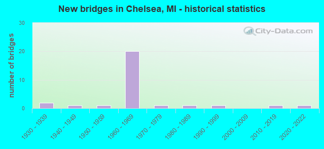
- New bridges - historical statistics
- 21930-1939
- 11940-1949
- 11950-1959
- 201960-1969
- 11970-1979
- 11980-1989
- 11990-1999
- 12010-2019
- 12020-2022

- Reconstructed bridges - Historical Statistics
- 11980-1989
- 01990-1999
- 12000-2009


- Bridge Condition - Deck
- 5.6%Very good
- 27.8%Good
- 44.4%Satisfactory
- 5.6%Fair
- 16.7%Poor

- Bridge Condition - Superstructure
- 11.1%Very good
- 27.8%Good
- 22.2%Satisfactory
- 33.3%Fair
- 5.6%Serious

- Bridge Condition - Substructure
- 11.1%Very good
- 22.2%Good
- 50.0%Satisfactory
- 11.1%Fair
- 5.6%Serious

- Bridge Condition - Channel
- 13.3%Very good
- 20.0%Good
- 53.3%Satisfactory
- 6.7%Fair
- 6.7%Poor

- Bridge Condition - Culverts
- 25.0%Very good
- 25.0%Fair
- 25.0%Poor
- 25.0%Serious
Find on map >> Show street view
Structure Number: 10809, Location: IN CHELSEA (Lat: 42.323750, Lng: -84.020747), Route carried "on" structure: State highway 52, Year Built: 1951, Status: Open, Structure Length: 0.91m (2.99ft), Average Daily Traffic: 16,199 (year 2007), Truck Traffic: 2%, Average Future Daily Traffic: 18,744 (year 2018), Design Load: H 20, Features Intersected: LETTS DRAIN
Minimum Vertical Clearance: 30.48m (100.00ft), Kilometerpoint: 30.268, Lanes on structure: 2, Base Highway Network: Yes (Inventory Route: 142, Subroute: 10), Owner: State Highway Agency, Approaching Roadway Width: 13.4m (44.0ft), Skew: 1 degrees, Material/Design: Concrete, Design/Construction: Tee Beam, Number Of Spans In Main Unit: 1, Length of Maximum Span: 9.1m (29.9ft), Curb or Sidewalk Widths: Left: 0.9m (3.0ft), Right: 0.9m (3.0ft), Curb-To-Curb Width: 14.0m (45.9ft), Out-to-Out Width: 16.5m (54.1ft)
Condition: Deck: Satisfactory, Superstructure: Satisfactory, Substructure: Good, Channel: Good, Operating Rating: 67.7 metric tons, Method Used To Determine Operating Rating: Load Factor (LF) rating reported by rating factor (RF) method using MS18 loading, Inventory Rating: 40.5 metric tons, Method Used To Determine Inventory Rating: Load Factor (LF) rating reported by rating factor (RF) method using MS18 loading, Structural Evaluation: Equal to present minimum criteria, Deck Geometry: Superior to present desirable criteria, Waterway Adequacy: Equal to present desirable criteria, Approach Roadway Alignment: Better than present minimum criteria, Length Of Structure Improvement: 0.91m (2.99ft), Designated Inspection Frequency: Every 24 months, Inspection Date: August 2020, Bridge Improvement Cost: $75,000, Roadway Improvement Cost: $2,000, Total Project Cost: $25,000, Deck Structure Type: Concrete Cast-file-Place, Wearing Surface/Protective System: Wearing Surface: Bituminous
Find on map >> Show street view
Structure Number: 10925, Location: 3.3 MI E OF M-52 (Lat: 42.298628, Lng: -83.960967), Route carried "on" structure: Interstate 94, Year Built: 1961, Status: Open, Structure Length: 1.34m (4.40ft), Average Daily Traffic: 28,818 (year 2007), Truck Traffic: 23%, Average Future Daily Traffic: 28,520 (year 2018), Design Load: HS 20+Mod, Features Intersected: MILL CREEK
Minimum Vertical Clearance: 30.48m (100.00ft), Kilometerpoint: 14.330, Lanes on structure: 2, Base Highway Network: Yes (Inventory Route: 142, Subroute: 9), Owner: State Highway Agency, Approaching Roadway Width: 12.8m (42.0ft), Skew: 10 degrees, Material/Design: Concrete, Design/Construction: Tee Beam, Number Of Spans In Main Unit: 1, Length of Maximum Span: 13.4m (44.0ft), Curb-To-Curb Width: 12.8m (42.0ft), Out-to-Out Width: 14.4m (47.2ft)
Condition: Deck: Satisfactory, Superstructure: Good, Substructure: Satisfactory, Channel: Satisfactory, Operating Rating: 67.1 metric tons, Method Used To Determine Operating Rating: Load Factor (LF) rating reported by rating factor (RF) method using MS18 loading, Inventory Rating: 40.2 metric tons, Method Used To Determine Inventory Rating: Load Factor (LF) rating reported by rating factor (RF) method using MS18 loading, Structural Evaluation: Equal to present minimum criteria, Deck Geometry: Equal to present desirable criteria, Waterway Adequacy: Equal to present desirable criteria, Approach Roadway Alignment: Better than present minimum criteria, Designated Inspection Frequency: Every 24 months, Inspection Date: June 2020, Deck Structure Type: Concrete Cast-file-Place, Wearing Surface/Protective System: Wearing Surface: Bituminous
Find on map >> Show street view
Structure Number: 10926, Location: 3.3 MI E OF M-52 (Lat: 42.298878, Lng: -83.961053), Route carried "on" structure: Interstate 94, Year Built: 1961, Status: Open, Structure Length: 1.34m (4.40ft), Average Daily Traffic: 28,818 (year 2007), Truck Traffic: 23%, Average Future Daily Traffic: 28,520 (year 2018), Design Load: HS 20+Mod, Features Intersected: MILL CREEK
Minimum Vertical Clearance: 30.48m (100.00ft), Kilometerpoint: 14.209, Lanes on structure: 2, Base Highway Network: Yes (Inventory Route: 142, Subroute: 10), Owner: State Highway Agency, Approaching Roadway Width: 12.8m (42.0ft), Skew: 10 degrees, Material/Design: Concrete, Design/Construction: Tee Beam, Number Of Spans In Main Unit: 1, Length of Maximum Span: 13.4m (44.0ft), Curb-To-Curb Width: 12.8m (42.0ft), Out-to-Out Width: 14.4m (47.2ft)
Condition: Deck: Satisfactory, Superstructure: Good, Substructure: Good, Channel: Satisfactory, Operating Rating: 67.1 metric tons, Method Used To Determine Operating Rating: Load Factor (LF) rating reported by rating factor (RF) method using MS18 loading, Inventory Rating: 40.2 metric tons, Method Used To Determine Inventory Rating: Load Factor (LF) rating reported by rating factor (RF) method using MS18 loading, Structural Evaluation: Better than present minimum criteria, Deck Geometry: Equal to present desirable criteria, Waterway Adequacy: Equal to present desirable criteria, Approach Roadway Alignment: Equal to present desirable criteria, Designated Inspection Frequency: Every 24 months, Inspection Date: June 2020, Deck Structure Type: Concrete Cast-file-Place, Wearing Surface/Protective System: Wearing Surface: Bituminous
Find on map >> Show street view
Structure Number: 10934, Location: 2.3 MI E OF JACKSON COL (Lat: 42.293264, Lng: -84.087983), Route carried "on" structure: Interstate 94, Year Built: 1960, Status: Open, Structure Length: 4.69m (15.39ft), Average Daily Traffic: 24,219 (year 2007), Truck Traffic: 16%, Average Future Daily Traffic: 27,077 (year 2018), Design Load: HS 20+Mod, Features Intersected: MDOT RR CORRIDOR
Minimum Vertical Clearance: 30.48m (100.00ft), Kilometerpoint: 3.766, Lanes on structure: 2, Base Highway Network: Yes (Inventory Route: 142, Subroute: 9), Owner: State Highway Agency, Approaching Roadway Width: 11.0m (36.1ft), Skew: 1 degrees, Material/Design: Steel, Design/Construction: Stringer/Multi-beam, Number Of Spans In Main Unit: 3, Length of Maximum Span: 15.5m (50.9ft), Curb-To-Curb Width: 12.8m (42.0ft), Out-to-Out Width: 14.4m (47.2ft)
Condition: Deck: Satisfactory, Superstructure: Fair, Substructure: Satisfactory, Operating Rating: 73.5 metric tons, Method Used To Determine Operating Rating: Load Factor (LF) rating reported by rating factor (RF) method using MS18 loading, Inventory Rating: 44.1 metric tons, Method Used To Determine Inventory Rating: Load Factor (LF) rating reported by rating factor (RF) method using MS18 loading, Structural Evaluation: Somewhat better than minimum adequacy, Deck Geometry: Equal to present desirable criteria, Underclear: High priority of corrective action, Approach Roadway Alignment: Better than present minimum criteria, Designated Inspection Frequency: Every 24 months, Inspection Date: July 2020, Bridge Improvement Cost: $95,000, Deck Structure Type: Concrete Cast-file-Place, Wearing Surface/Protective System: Wearing Surface: Latex Concrete
Find on map >> Show street view
Structure Number: 10936, Location: 1.9 MI E OF JACKSON COL (Lat: 42.297269, Lng: -84.093917), Route carried "on" structure: County highway 8168, Year Built: 1960, Status: Open, Structure Length: 7.22m (23.69ft), Average Daily Traffic: 1,349 (year 1994), Truck Traffic: 3%, Average Future Daily Traffic: 1,551 (year 2014), Design Load: HS 20, Features Intersected: I-94, Facility Carried by Structure: KALMBACH RD
Minimum Vertical Clearance: 30.48m (100.00ft), Kilometerpoint: 0.708, Lanes on structure: 2, Lanes under structure: 4, Owner: State Highway Agency, Approaching Roadway Width: 10.3m (33.8ft), Skew: 1 degrees, Material/Design: Steel, Design/Construction: Stringer/Multi-beam, Number Of Spans In Main Unit: 4, Length of Maximum Span: 25.0m (82.0ft), Curb-To-Curb Width: 8.7m (28.5ft), Out-to-Out Width: 10.0m (32.8ft)
Condition: Deck: Poor, Superstructure: Fair, Substructure: Satisfactory, Operating Rating: 65.8 metric tons, Method Used To Determine Operating Rating: Load Factor (LF) rating reported by rating factor (RF) method using MS18 loading, Inventory Rating: 39.5 metric tons, Method Used To Determine Inventory Rating: Load Factor (LF) rating reported by rating factor (RF) method using MS18 loading, Structural Evaluation: Somewhat better than minimum adequacy, Deck Geometry: Somewhat better than minimum adequacy, Underclear: Somewhat better than minimum adequacy, Approach Roadway Alignment: Equal to present desirable criteria, Designated Inspection Frequency: Every 12 months, Inspection Date: June 2021, Deck Structure Type: Concrete Cast-file-Place, Wearing Surface/Protective System: Wearing Surface: Latex Concrete
Find on map >> Show street view
Structure Number: 10937, Location: 3.3 MI E OF JACKSON COL (Lat: 42.292253, Lng: -84.069319), Route carried "on" structure: Interstate 94, Year Built: 1960, Status: Open, Structure Length: 3.62m (11.88ft), Average Daily Traffic: 25,302 (year 2007), Truck Traffic: 15%, Average Future Daily Traffic: 28,365 (year 2018), Design Load: HS 20, Features Intersected: PIERCE RD
Minimum Vertical Clearance: 30.48m (100.00ft), Kilometerpoint: 5.367, Lanes on structure: 2, Lanes under structure: 2, Base Highway Network: Yes (Inventory Route: 142, Subroute: 9), Owner: State Highway Agency, Approaching Roadway Width: 12.8m (42.0ft), Skew: 12 degrees, Material/Design: Steel, Design/Construction: Stringer/Multi-beam, Number Of Spans In Main Unit: 3, Length of Maximum Span: 14.0m (45.9ft), Curb-To-Curb Width: 12.8m (42.0ft), Out-to-Out Width: 14.3m (46.9ft)
Condition: Deck: Satisfactory, Superstructure: Fair, Substructure: Satisfactory, Operating Rating: 85.1 metric tons, Method Used To Determine Operating Rating: Load Factor (LF), Inventory Rating: 51.0 metric tons, Method Used To Determine Inventory Rating: Load Factor (LF), Structural Evaluation: Somewhat better than minimum adequacy, Deck Geometry: Equal to present desirable criteria, Underclear: Meets minimum limits, Approach Roadway Alignment: Better than present minimum criteria, Length Of Structure Improvement: 3.63m (11.91ft), Designated Inspection Frequency: Every 24 months, Inspection Date: July 2020, Bridge Improvement Cost: $105,000, Roadway Improvement Cost: $7,000, Total Project Cost: $84,000, Deck Structure Type: Concrete Cast-file-Place, Wearing Surface/Protective System: Wearing Surface: Latex Concrete
Find on map >> Show street view
Structure Number: 10938, Location: 3.3 MI E OF JACKSON COL (Lat: 42.292500, Lng: -84.069186), Route carried "on" structure: Interstate 94, Year Built: 1960, Status: Open, Structure Length: 3.62m (11.88ft), Average Daily Traffic: 25,302 (year 2007), Truck Traffic: 15%, Average Future Daily Traffic: 28,365 (year 2018), Design Load: HS 20, Features Intersected: PIERCE RD
Minimum Vertical Clearance: 30.48m (100.00ft), Kilometerpoint: 5.264, Lanes on structure: 2, Lanes under structure: 2, Base Highway Network: Yes (Inventory Route: 142, Subroute: 10), Owner: State Highway Agency, Approaching Roadway Width: 12.8m (42.0ft), Skew: 2 degrees, Material/Design: Steel, Design/Construction: Stringer/Multi-beam, Number Of Spans In Main Unit: 3, Length of Maximum Span: 13.7m (44.9ft), Curb-To-Curb Width: 12.8m (42.0ft), Out-to-Out Width: 14.3m (46.9ft)
Condition: Deck: Satisfactory, Superstructure: Satisfactory, Substructure: Satisfactory, Operating Rating: 65.4 metric tons, Method Used To Determine Operating Rating: Load Factor (LF) rating reported by rating factor (RF) method using MS18 loading, Inventory Rating: 39.2 metric tons, Method Used To Determine Inventory Rating: Load Factor (LF) rating reported by rating factor (RF) method using MS18 loading, Structural Evaluation: Equal to present minimum criteria, Deck Geometry: Equal to present desirable criteria, Underclear: Meets minimum limits, Approach Roadway Alignment: Better than present minimum criteria, Length Of Structure Improvement: 3.63m (11.91ft), Designated Inspection Frequency: Every 24 months, Inspection Date: July 2020, Bridge Improvement Cost: $105,000, Roadway Improvement Cost: $7,000, Total Project Cost: $84,000, Deck Structure Type: Concrete Cast-file-Place, Wearing Surface/Protective System: Wearing Surface: Latex Concrete
Find on map >> Show street view
Structure Number: 10939, Location: 1.5 MI S OF CHELSEA (Lat: 42.294686, Lng: -84.026939), Route carried "on" structure: State highway 52, Year Built: 1960, Status: Open, Structure Length: 7.13m (23.39ft), Average Daily Traffic: 6,756 (year 2007), Truck Traffic: 5%, Average Future Daily Traffic: 8,965 (year 2018), Design Load: HS 20, Features Intersected: I-94
Minimum Vertical Clearance: 30.48m (100.00ft), Kilometerpoint: 26.920, Lanes on structure: 4, Lanes under structure: 6, Base Highway Network: Yes (Inventory Route: 142, Subroute: 10), Owner: State Highway Agency, Approaching Roadway Width: 13.4m (44.0ft), Skew: 2 degrees, Material/Design: Steel, Design/Construction: Stringer/Multi-beam, Number Of Spans In Main Unit: 4, Length of Maximum Span: 23.1m (75.8ft), Curb-To-Curb Width: 17.3m (56.8ft), Out-to-Out Width: 18.5m (60.7ft)
Condition: Deck: Poor, Superstructure: Fair, Substructure: Fair, Operating Rating: 62.2 metric tons, Method Used To Determine Operating Rating: Load Factor (LF) rating reported by rating factor (RF) method using MS18 loading, Inventory Rating: 33.4 metric tons, Method Used To Determine Inventory Rating: Load Factor (LF) rating reported by rating factor (RF) method using MS18 loading, Structural Evaluation: Somewhat better than minimum adequacy, Deck Geometry: Somewhat better than minimum adequacy, Underclear: Meets minimum limits, Approach Roadway Alignment: Better than present minimum criteria, Length Of Structure Improvement: 7.13m (23.39ft), Designated Inspection Frequency: Every 12 months, Inspection Date: April 2021, Bridge Improvement Cost: $53,000, Roadway Improvement Cost: $5,000, Total Project Cost: $62,000, Deck Structure Type: Concrete Cast-file-Place, Wearing Surface/Protective System: Wearing Surface: Latex Concrete
Find on map >> Show street view
Structure Number: 1094, Location: 1.0 MI E OF M-52 (Lat: 42.295750, Lng: -84.005533), Route carried "on" structure: County highway , Year Built: 1960, Status: Open, Structure Length: 6.37m (20.90ft), Average Daily Traffic: 150 (year 1997), Truck Traffic: 3%, Average Future Daily Traffic: 173 (year 2017), Design Load: H 15, Features Intersected: I-94, Facility Carried by Structure: FREER RD
Minimum Vertical Clearance: 30.48m (100.00ft), Kilometerpoint: 1.770, Lanes on structure: 2, Lanes under structure: 4, Owner: State Highway Agency, Approaching Roadway Width: 9.1m (29.9ft), Material/Design: Prestressed concrete, Design/Construction: Stringer/Multi-beam, Number Of Spans In Main Unit: 4, Length of Maximum Span: 21.6m (70.9ft), Curb-To-Curb Width: 8.7m (28.5ft), Out-to-Out Width: 10.0m (32.8ft)
Condition: Deck: Satisfactory, Superstructure: Satisfactory, Substructure: Satisfactory, Operating Rating: 56.7 metric tons, Method Used To Determine Operating Rating: Load Factor (LF) rating reported by rating factor (RF) method using MS18 loading, Inventory Rating: 26.6 metric tons, Method Used To Determine Inventory Rating: Load Factor (LF) rating reported by rating factor (RF) method using MS18 loading, Structural Evaluation: Equal to present minimum criteria, Deck Geometry: Equal to present minimum criteria, Underclear: Meets minimum limits, Approach Roadway Alignment: Equal to present minimum criteria, Designated Inspection Frequency: Every 24 months, Inspection Date: June 2020, Deck Structure Type: Concrete Cast-file-Place, Wearing Surface/Protective System: Wearing Surface: Monolithic Concrete
Find on map >> Show street view
Structure Number: 10941, Location: 2.6 MI E OF M-52 (Lat: 42.297786, Lng: -83.973947), Route carried "on" structure: County highway 8160, Year Built: 1960, Status: Open, Structure Length: 7.18m (23.56ft), Average Daily Traffic: 9,461 (year 1997), Truck Traffic: 3%, Average Future Daily Traffic: 10,880 (year 2017), Design Load: HS 20, Features Intersected: I-94, Facility Carried by Structure: OLD US-12
Minimum Vertical Clearance: 30.48m (100.00ft), Kilometerpoint: 14.665, Lanes on structure: 2, Lanes under structure: 4, Owner: State Highway Agency, Approaching Roadway Width: 10.3m (33.8ft), Skew: 2 degrees, Material/Design: Steel, Design/Construction: Stringer/Multi-beam, Number Of Spans In Main Unit: 4, Length of Maximum Span: 24.3m (79.7ft), Curb-To-Curb Width: 8.9m (29.2ft), Out-to-Out Width: 10.2m (33.5ft)
Condition: Deck: Fair, Superstructure: Fair, Substructure: Satisfactory, Operating Rating: 82.9 metric tons, Method Used To Determine Operating Rating: Load Factor (LF) rating reported by rating factor (RF) method using MS18 loading, Inventory Rating: 49.6 metric tons, Method Used To Determine Inventory Rating: Load Factor (LF) rating reported by rating factor (RF) method using MS18 loading, Structural Evaluation: Somewhat better than minimum adequacy, Deck Geometry: Meets minimum limits, Underclear: Meets minimum limits, Approach Roadway Alignment: Better than present minimum criteria, Designated Inspection Frequency: Every 24 months, Inspection Date: June 2020, Deck Structure Type: Concrete Cast-file-Place, Wearing Surface/Protective System: Wearing Surface: Epoxy Overlay
Find on map >> Show street view
Structure Number: 10978, Location: LIMA TWP SECTION 21 (Lat: 42.296025, Lng: -83.958833), Route carried "on" structure: County highway 8160, Year Built: 1937, Status: Open, Structure Length: 0.94m (3.08ft), Average Daily Traffic: 5,031 (year 2003), Truck Traffic: 12%, Average Future Daily Traffic: 9,086 (year 2023), Design Load: HS 20+Mod, Features Intersected: MILL CREEK, Facility Carried by Structure: JACKSON AVE
Minimum Vertical Clearance: 30.48m (100.00ft), Kilometerpoint: 15.972, Lanes on structure: 2, Owner: County Highway Agency, Approaching Roadway Width: 15.9m (52.2ft), Skew: 3 degrees, Material/Design: Concrete, Design/Construction: Tee Beam, Number Of Spans In Main Unit: 1, Length of Maximum Span: 8.5m (27.9ft), Curb-To-Curb Width: 10.1m (33.1ft), Out-to-Out Width: 20.1m (65.9ft)
Condition: Deck: Good, Superstructure: Satisfactory, Substructure: Satisfactory, Channel: Fair, Operating Rating: 54.5 metric tons, Method Used To Determine Operating Rating: Field evaluation and documented engineering judgment, Inventory Rating: 32.7 metric tons, Method Used To Determine Inventory Rating: Field evaluation and documented engineering judgment, Structural Evaluation: Equal to present minimum criteria, Deck Geometry: Meets minimum limits, Waterway Adequacy: Equal to present desirable criteria, Approach Roadway Alignment: Equal to present desirable criteria, Designated Inspection Frequency: Every 24 months, Inspection Date: April 2021, Deck Structure Type: Concrete Cast-file-Place, Wearing Surface/Protective System: Wearing Surface: Bituminous
Find on map >> Show street view
Structure Number: 10987, Location: LIMA TWP SEC 8 (Lat: 42.322175, Lng: -83.979350), Route carried "on" structure: County highway 8168, Year Built: 1983, Status: Posted for load, Structure Length: 1.89m (6.20ft), Average Daily Traffic: 3,320 (year 2005), Truck Traffic: 9%, Average Future Daily Traffic: 5,996 (year 2025), Design Load: HS 20+Mod, Features Intersected: LETTS CREEK, Facility Carried by Structure: DEXTER-CHELSEA RD
Minimum Vertical Clearance: 30.48m (100.00ft), Kilometerpoint: 3.257, Lanes on structure: 2, Owner: County Highway Agency, Approaching Roadway Width: 11.0m (36.1ft), Skew: 4 degrees, Material/Design: Prestressed concrete, Design/Construction: Box Beam or Girders - Multiple, Number Of Spans In Main Unit: 1, Length of Maximum Span: 18.9m (62.0ft), Curb-To-Curb Width: 11.0m (36.1ft), Out-to-Out Width: 11.4m (37.4ft)
Condition: Deck: Satisfactory, Superstructure: Fair, Substructure: Very good, Channel: Good, Operating Rating: 49.2 metric tons, Method Used To Determine Operating Rating: Load Factor (LF) rating reported by rating factor (RF) method using MS18 loading, Inventory Rating: 29.5 metric tons, Method Used To Determine Inventory Rating: Load Factor (LF) rating reported by rating factor (RF) method using MS18 loading, Structural Evaluation: Somewhat better than minimum adequacy, Deck Geometry: Somewhat better than minimum adequacy, Waterway Adequacy: Equal to present desirable criteria, Approach Roadway Alignment: Equal to present desirable criteria, Bridge Posting: Required (Relationship of Operating Rating to Maximum Legal Load: 10.0 - 19.9% below), Length Of Structure Improvement: 2.62m (8.60ft), Designated Inspection Frequency: Every 24 months, Inspection Date: July 2021, Bridge Improvement Cost: $252,000, Roadway Improvement Cost: $60,000, Total Project Cost: $330,000, Deck Structure Type: Concrete Precast Panels, Wearing Surface/Protective System: Wearing Surface: Bituminous
Find on map >> Show street view
Structure Number: 11013, Location: LIMA TWP SEC 30 & 31 (Lat: 42.265700, Lng: -83.999625), Route carried "on" structure: County highway , Year Built: 1962, Status: Open, Structure Length: 0.91m (2.99ft), Average Daily Traffic: 97 (year 2003), Truck Traffic: 5%, Average Future Daily Traffic: 108 (year 2023), Design Load: HS 20+Mod, Features Intersected: MILL CREEK, Facility Carried by Structure: SAGER RD
Minimum Vertical Clearance: 30.48m (100.00ft), Kilometerpoint: 2.847, Lanes on structure: 2, Owner: County Highway Agency, Approaching Roadway Width: 7.0m (23.0ft), Material/Design: Prestressed concrete, Design/Construction: Box Beam or Girders - Multiple, Number Of Spans In Main Unit: 1, Length of Maximum Span: 9.1m (29.9ft), Curb-To-Curb Width: 4.9m (16.1ft), Out-to-Out Width: 5.5m (18.0ft)
Condition: Deck: Poor, Superstructure: Serious, Substructure: Serious, Channel: Poor, Operating Rating: 45.3 metric tons, Method Used To Determine Operating Rating: Load Factor (LF), Inventory Rating: 27.2 metric tons, Method Used To Determine Inventory Rating: Load Factor (LF), Structural Evaluation: High priority of corrective action, Deck Geometry: High priority of corrective action, Waterway Adequacy: Better than present minimum criteria, Approach Roadway Alignment: Equal to present desirable criteria, Length Of Structure Improvement: 1.28m (4.20ft), Designated Inspection Frequency: Every 12 months, Inspection Date: May 2021, Bridge Improvement Cost: $140,000, Roadway Improvement Cost: $20,000, Total Project Cost: $160,000, Deck Structure Type: Concrete Precast Panels, Wearing Surface/Protective System: Wearing Surface: Gravel
Find on map >> Show street view
Structure Number: 11017, Location: LIMA TWP SEC 9 & 16 (Lat: 42.310408, Lng: -83.963997), Route carried "on" structure: County highway , Year Built: 1997, Status: Open, Structure Length: 2.20m (7.22ft), Average Daily Traffic: 233 (year 2003), Truck Traffic: 3%, Average Future Daily Traffic: 298 (year 2023), Design Load: HS 20, Features Intersected: MILL CREEK, Facility Carried by Structure: TRINKLE ROAD
Minimum Vertical Clearance: 30.48m (100.00ft), Kilometerpoint: 3.443, Lanes on structure: 2, Owner: County Highway Agency, Approaching Roadway Width: 9.1m (29.9ft), Skew: 2 degrees, Material/Design: Prestressed concrete, Design/Construction: Box Beam or Girders - Multiple, Number Of Spans In Main Unit: 1, Length of Maximum Span: 20.7m (67.9ft), Curb-To-Curb Width: 8.8m (28.9ft), Out-to-Out Width: 10.1m (33.1ft)
Condition: Deck: Good, Superstructure: Good, Substructure: Good, Channel: Good, Inventory Rating: 60.8 metric tons, Method Used To Determine Inventory Rating: Load Factor (LF), Structural Evaluation: Better than present minimum criteria, Deck Geometry: Equal to present minimum criteria, Waterway Adequacy: Equal to present desirable criteria, Approach Roadway Alignment: Equal to present desirable criteria, Designated Inspection Frequency: Every 24 months, Inspection Date: July 2021, Deck Structure Type: Concrete Precast Panels, Wearing Surface/Protective System: Wearing Surface: Integral Concrete, Deck Protection: Epoxy Coated Reinforcing
Find on map >> Show street view
Structure Number: 11019, Location: LIMA TWP SEC 33 & 34 (Lat: 42.266553, Lng: -83.955756), Route carried "on" structure: County highway , Year Built: 1941, Year Reconstructed: 1986, Status: Posted for load, Structure Length: 1.13m (3.71ft), Average Daily Traffic: 43 (year 2003), Truck Traffic: 6%, Average Future Daily Traffic: 57 (year 2023), Design Load: HS 20, Features Intersected: MILL CREEK, Facility Carried by Structure: LIMA CENTER ROAD
Minimum Vertical Clearance: 30.48m (100.00ft), Kilometerpoint: 1.479, Lanes on structure: 2, Owner: County Highway Agency, Approaching Roadway Width: 4.9m (16.1ft), Material/Design: Steel, Design/Construction: Stringer/Multi-beam, Number Of Spans In Main Unit: 1, Length of Maximum Span: 7.6m (24.9ft), Curb-To-Curb Width: 6.4m (21.0ft), Out-to-Out Width: 7.0m (23.0ft)
Condition: Deck: Good, Superstructure: Very good, Substructure: Fair, Channel: Satisfactory, Operating Rating: 17.0 metric tons, Method Used To Determine Operating Rating: Field evaluation and documented engineering judgment, Inventory Rating: 10.1 metric tons, Method Used To Determine Inventory Rating: Field evaluation and documented engineering judgment, Structural Evaluation: High priority of corrective action, Deck Geometry: Somewhat better than minimum adequacy, Waterway Adequacy: Equal to present desirable criteria, Approach Roadway Alignment: High priority of corrective action, Bridge Posting: Required (Relationship of Operating Rating to Maximum Legal Load: > 39.9% below), Designated Inspection Frequency: Every 24 months, Inspection Date: July 2021, Deck Structure Type: Corrugated Steel, Wearing Surface/Protective System: Wearing Surface: Bituminous
Find on map >> Show street view
Structure Number: 11024, Location: LIMA TWP SEC 16 (Lat: 42.299175, Lng: -83.961131), Route carried "on" structure: County highway , Year Built: 1961, Status: Open, Structure Length: 1.34m (4.40ft), Average Daily Traffic: 233 (year 2003), Truck Traffic: 7%, Average Future Daily Traffic: 280 (year 2023), Design Load: HS 20, Features Intersected: LUICK CREEK, Facility Carried by Structure: SEITZ DRIVE
Minimum Vertical Clearance: 30.48m (100.00ft), Kilometerpoint: 1.307, Lanes on structure: 2, Owner: County Highway Agency, Approaching Roadway Width: 9.1m (29.9ft), Material/Design: Concrete, Design/Construction: Tee Beam, Number Of Spans In Main Unit: 1, Length of Maximum Span: 13.4m (44.0ft), Curb or Sidewalk Widths: Left: 0.4m (1.3ft), Right: 0.4m (1.3ft), Curb-To-Curb Width: 7.9m (25.9ft), Out-to-Out Width: 9.0m (29.5ft)
Condition: Deck: Good, Superstructure: Good, Substructure: Good, Channel: Satisfactory, Operating Rating: 54.5 metric tons, Method Used To Determine Operating Rating: Field evaluation and documented engineering judgment, Inventory Rating: 32.7 metric tons, Method Used To Determine Inventory Rating: Field evaluation and documented engineering judgment, Structural Evaluation: Better than present minimum criteria, Deck Geometry: Somewhat better than minimum adequacy, Waterway Adequacy: Equal to present desirable criteria, Approach Roadway Alignment: Equal to present desirable criteria, Length Of Structure Improvement: 1.83m (6.00ft), Designated Inspection Frequency: Every 24 months, Inspection Date: July 2021, Bridge Improvement Cost: $160,000, Roadway Improvement Cost: $75,000, Total Project Cost: $240,000, Deck Structure Type: Concrete Cast-file-Place, Wearing Surface/Protective System: Wearing Surface: Bituminous
Find on map >> Show street view
Structure Number: 1104, Location: SHARON TWP SEC 1 (Lat: 42.247625, Lng: -84.029444), Route carried "on" structure: County highway , Year Built: 1970, Year Reconstructed: 2011, Status: Posted for load, Structure Length: 0.82m (2.69ft), Average Daily Traffic: 154 (year 2005), Truck Traffic: 5%, Average Future Daily Traffic: 278 (year 2025), Design Load: HL 93, Features Intersected: MILL CREEK, Facility Carried by Structure: WALDO RD
Minimum Vertical Clearance: 30.48m (100.00ft), Kilometerpoint: 0.319, Lanes on structure: 2, Owner: County Highway Agency, Approaching Roadway Width: 6.1m (20.0ft), Material/Design: Steel, Design/Construction: Stringer/Multi-beam, Number Of Spans In Main Unit: 1, Length of Maximum Span: 8.2m (26.9ft), Curb-To-Curb Width: 6.1m (20.0ft), Out-to-Out Width: 6.7m (22.0ft)
Condition: Deck: Good, Superstructure: Very good, Substructure: Satisfactory, Channel: Satisfactory, Operating Rating: 17.0 metric tons, Method Used To Determine Operating Rating: Field evaluation and documented engineering judgment, Inventory Rating: 10.1 metric tons, Method Used To Determine Inventory Rating: Field evaluation and documented engineering judgment, Structural Evaluation: High priority of corrective action, Deck Geometry: Meets minimum limits, Waterway Adequacy: Equal to present desirable criteria, Approach Roadway Alignment: Equal to present desirable criteria, Bridge Posting: Required (Relationship of Operating Rating to Maximum Legal Load: > 39.9% below), Designated Inspection Frequency: Every 24 months, Inspection Date: July 2021, Deck Structure Type: Corrugated Steel, Wearing Surface/Protective System: Wearing Surface: Bituminous
Find on map >> Show street view
Structure Number: 13914, Location: SYLVAN TWP SEC 2 (Lat: 42.324167, Lng: -84.042417), Route carried "on" structure: County highway , Year Built: 1968, Status: Open, Structure Length: 0.75m (2.46ft), Average Daily Traffic: 200 (year 2014), Average Future Daily Traffic: 230 (year 2034), Design Load: HS 20, Features Intersected: LETTS CREEK, Facility Carried by Structure: SIBLEY ROAD (WEST)
Minimum Vertical Clearance: 30.48m (100.00ft), Kilometerpoint: 0.966, Lanes on structure: 2, Owner: County Highway Agency, Approaching Roadway Width: 7.3m (24.0ft), Skew: 2 degrees, Material/Design: Steel, Design/Construction: Culvert, Number Of Spans In Main Unit: 2, Length of Maximum Span: 3.6m (11.8ft), Out-to-Out Width: 14.0m (45.9ft)
Condition: Channel: Satisfactory, Culverts: Fair, Operating Rating: 39.5 metric tons, Method Used To Determine Operating Rating: Load Factor (LF) rating reported by rating factor (RF) method using MS18 loading, Inventory Rating: 32.4 metric tons, Method Used To Determine Inventory Rating: Load Factor (LF) rating reported by rating factor (RF) method using MS18 loading, Structural Evaluation: Somewhat better than minimum adequacy, Waterway Adequacy: Somewhat better than minimum adequacy, Approach Roadway Alignment: Better than present minimum criteria, Designated Inspection Frequency: Every 24 months, Inspection Date: September 2021, Wearing Surface/Protective System: Wearing Surface: Gravel
Find on map >> Show street view
Structure Number: 13915, Location: SYLVAN TWP SEC 2 (Lat: 42.324250, Lng: -84.036111), Route carried "on" structure: County highway , Year Built: 1968, Status: Open, Structure Length: 0.76m (2.49ft), Average Daily Traffic: 200 (year 2014), Average Future Daily Traffic: 230 (year 2034), Design Load: HS 20, Features Intersected: LETTS CREEK, Facility Carried by Structure: SIBLEY ROAD (EAST)
Minimum Vertical Clearance: 30.48m (100.00ft), Kilometerpoint: 1.487, Lanes on structure: 2, Owner: County Highway Agency, Approaching Roadway Width: 7.3m (24.0ft), Skew: 4 degrees, Material/Design: Steel, Design/Construction: Culvert, Number Of Spans In Main Unit: 2, Length of Maximum Span: 3.8m (12.5ft), Out-to-Out Width: 14.0m (45.9ft)
Condition: Channel: Satisfactory, Culverts: Poor, Operating Rating: 97.2 metric tons, Method Used To Determine Operating Rating: Load Factor (LF) rating reported by rating factor (RF) method using MS18 loading, Inventory Rating: 97.2 metric tons, Method Used To Determine Inventory Rating: Load Factor (LF) rating reported by rating factor (RF) method using MS18 loading, Structural Evaluation: Meets minimum limits, Waterway Adequacy: Somewhat better than minimum adequacy, Approach Roadway Alignment: Better than present minimum criteria, Designated Inspection Frequency: Every 12 months, Inspection Date: September 2021, Wearing Surface/Protective System: Wearing Surface: Bituminous
Find on map >> Show street view
Structure Number: 13916, Location: SLVAN TWP SEC 2 (Lat: 42.325861, Lng: -84.039333), Route carried "on" structure: County highway , Year Built: 1968, Status: Temporarily open, Structure Length: 0.71m (2.33ft), Average Daily Traffic: 200 (year 2014), Average Future Daily Traffic: 230 (year 2034), Features Intersected: LETTS CREEK, Facility Carried by Structure: BUSH ROAD
Minimum Vertical Clearance: 30.48m (100.00ft), Kilometerpoint: 0.188, Lanes on structure: 2, Owner: County Highway Agency, Approaching Roadway Width: 7.3m (24.0ft), Material/Design: Steel, Design/Construction: Culvert, Number Of Spans In Main Unit: 2, Length of Maximum Span: 3.2m (10.5ft), Out-to-Out Width: 18.9m (62.0ft)
Condition: Channel: Satisfactory, Culverts: Serious, Operating Rating: 16.2 metric tons, Method Used To Determine Operating Rating: Load Factor (LF) rating reported by rating factor (RF) method using MS18 loading, Inventory Rating: 9.7 metric tons, Method Used To Determine Inventory Rating: Load Factor (LF) rating reported by rating factor (RF) method using MS18 loading, Structural Evaluation: High priority of corrective action, Waterway Adequacy: Somewhat better than minimum adequacy, Approach Roadway Alignment: Better than present minimum criteria, Designated Inspection Frequency: Every 12 months, Inspection Date: September 2021, Wearing Surface/Protective System: Wearing Surface: Bituminous
Find on map >> Show street view
Structure Number: 13917, Location: LIMA TWP SEC 6 (Lat: 42.332583, Lng: -84.015028), Route carried "on" structure: County highway , Year Built: 2012, Status: Open, Structure Length: 0.67m (2.20ft), Average Daily Traffic: 200 (year 2014), Average Future Daily Traffic: 230 (year 2034), Design Load: HS 20, Features Intersected: MILL CREEK FORK, Facility Carried by Structure: MCKINLEY ROAD
Minimum Vertical Clearance: 30.48m (100.00ft), Kilometerpoint: 1.675, Lanes on structure: 2, Owner: County Highway Agency, Approaching Roadway Width: 79.2m (259.8ft), Material/Design: Wood or Timber, Design/Construction: Slab, Number Of Spans In Main Unit: 1, Length of Maximum Span: 6.4m (21.0ft), Curb-To-Curb Width: 7.6m (24.9ft), Out-to-Out Width: 8.2m (26.9ft)
Condition: Deck: Very good, Superstructure: Good, Substructure: Very good, Channel: Very good, Operating Rating: 65.0 metric tons, Method Used To Determine Operating Rating: Allowable Stress (AS), Inventory Rating: 47.0 metric tons, Method Used To Determine Inventory Rating: Allowable Stress (AS), Structural Evaluation: Better than present minimum criteria, Deck Geometry: Somewhat better than minimum adequacy, Waterway Adequacy: Equal to present desirable criteria, Approach Roadway Alignment: Better than present minimum criteria, Designated Inspection Frequency: Every 24 months, Inspection Date: September 2021, Deck Structure Type: Wood or Timber, Wearing Surface/Protective System: Wearing Surface: Bituminous
Find on map >> Show street view
Structure Number: 1405, Location: 0.6 MI E OF CONWAY RD (Lat: 42.313200, Lng: -84.043503), Route carried "on" structure: County highway 8168, Year Built: 2020, Status: Open, Structure Length: 0.69m (2.26ft), Average Daily Traffic: 1,530 (year 2018), Truck Traffic: 5%, Average Future Daily Traffic: 1,890 (year 2038), Design Load: Greater than HL93, Features Intersected: LETTS CREEK, Facility Carried by Structure: CAVANAUGH LAKE RD
Minimum Vertical Clearance: 30.48m (100.00ft), Kilometerpoint: 2.487, Lanes on structure: 2, Owner: County Highway Agency, Approaching Roadway Width: 9.4m (30.8ft), Material/Design: Aluminum, Iron, Design/Construction: Culvert, Number Of Spans In Main Unit: 1, Length of Maximum Span: 6.9m (22.6ft), Curb-To-Curb Width: 9.4m (30.8ft), Out-to-Out Width: 12.2m (40.0ft)
Condition: Channel: Very good, Culverts: Very good, Operating Rating: 76.8 metric tons, Method Used To Determine Operating Rating: Load and Resistance Factor Rating (LRFR) rating reported by rating factor(RF) method using HL-93 loadings, Inventory Rating: 59.3 metric tons, Method Used To Determine Inventory Rating: Load and Resistance Factor Rating (LRFR) rating reported by rating factor(RF) method using HL-93 loadings, Structural Evaluation: Equal to present desirable criteria, Deck Geometry: Somewhat better than minimum adequacy, Waterway Adequacy: Equal to present desirable criteria, Approach Roadway Alignment: Equal to present desirable criteria, Designated Inspection Frequency: Every 24 months, Inspection Date: July 2021, Wearing Surface/Protective System: Wearing Surface: Bituminous
Find on map >> Show street view
Structure Number: 10936, Location: 1.9 MI E OF JACKSON COL (Lat: 42.297269, Lng: -84.093917), Route carried "under" structure: Interstate 94, Year Built: 1960, Structure Length: 0. m, Average Daily Traffic: 48,438 (year 2007), Truck Traffic: 16%, Features Intersected: I-94, Facility Carried by Structure: KALMBACH RD
Minimum Vertical Clearance: 5.11m (16.77ft), Kilometerpoint: 3.090, Lanes on structure: 2, Lanes under structure: 4, Material/Design: Steel, Design/Construction: Stringer/Multi-beam, Length of Maximum Span: 25.0m (82.0ft)
Find on map >> Show street view
Structure Number: 10937, Location: 3.3 MI E OF JACKSON COL (Lat: 42.292253, Lng: -84.069319), Route carried "under" structure: County highway 8160, Year Built: 1960, Structure Length: 0. m, Average Daily Traffic: 1,210 (year 1994), Truck Traffic: 3%, Features Intersected: PIERCE RD, Facility Carried by Structure: I-94 EB
Minimum Vertical Clearance: 4.34m (14.24ft), Kilometerpoint: 5.863, Lanes on structure: 2, Lanes under structure: 2, Material/Design: Steel, Design/Construction: Stringer/Multi-beam, Length of Maximum Span: 14.0m (45.9ft)
Find on map >> Show street view
Structure Number: 10938, Location: 3.3 MI E OF JACKSON COL (Lat: 42.292500, Lng: -84.069186), Route carried "under" structure: County highway 8160, Year Built: 1960, Structure Length: 0. m, Average Daily Traffic: 1,210 (year 1997), Truck Traffic: 3%, Features Intersected: PIERCE RD, Facility Carried by Structure: I-94 WB
Minimum Vertical Clearance: 4.42m (14.50ft), Kilometerpoint: 5.894, Lanes on structure: 2, Lanes under structure: 2, Material/Design: Steel, Design/Construction: Stringer/Multi-beam, Length of Maximum Span: 13.7m (44.9ft)
Find on map >> Show street view
Structure Number: 10939, Location: 1.5 MI S OF CHELSEA (Lat: 42.294686, Lng: -84.026939), Route carried "under" structure: Interstate 94, Year Built: 1960, Structure Length: 0. m, Average Daily Traffic: 52,222 (year 2007), Truck Traffic: 26%, Features Intersected: I-94, Facility Carried by Structure: M-52
Minimum Vertical Clearance: 5.08m (16.67ft), Kilometerpoint: 8.865, Lanes on structure: 4, Lanes under structure: 6, Material/Design: Steel, Design/Construction: Stringer/Multi-beam, Length of Maximum Span: 23.1m (75.8ft)
Find on map >> Show street view
Structure Number: 1094, Location: 1.0 MI E OF M-52 (Lat: 42.295750, Lng: -84.005533), Route carried "under" structure: Interstate 94, Year Built: 1960, Structure Length: 0. m, Average Daily Traffic: 52,222 (year 2007), Truck Traffic: 26%, Features Intersected: I-94, Facility Carried by Structure: FREER RD
Minimum Vertical Clearance: 4.95m (16.24ft), Kilometerpoint: 10.643, Lanes on structure: 2, Lanes under structure: 4, Material/Design: Prestressed concrete, Design/Construction: Stringer/Multi-beam, Length of Maximum Span: 21.6m (70.9ft)
Find on map >> Show street view
Structure Number: 10941, Location: 2.6 MI E OF M-52 (Lat: 42.297786, Lng: -83.973947), Route carried "under" structure: Interstate 94, Year Built: 1960, Structure Length: 0. m, Average Daily Traffic: 66,925 (year 2020), Truck Traffic: 13%, Features Intersected: I-94, Facility Carried by Structure: OLD US-12
Minimum Vertical Clearance: 5.05m (16.57ft), Kilometerpoint: 13.257, Lanes on structure: 2, Lanes under structure: 4, Material/Design: Steel, Design/Construction: Stringer/Multi-beam, Length of Maximum Span: 24.3m (79.7ft)
Find on map >> Show street view
Structure Number: 1095, Location: 2.3 MI E OF JACKSON COL (Lat: 42.294542, Lng: -84.085378), Route carried "under" structure: Interstate 94, Year Built: 1936, Structure Length: 0. m, Average Daily Traffic: 24,219 (year 2007), Truck Traffic: 16%, Features Intersected: I-94 WB, Facility Carried by Structure: MDOT RR CORRIDOR
Minimum Vertical Clearance: 4.90m (16.08ft), Kilometerpoint: 3.872, Lanes under structure: 2, Material/Design: Steel, Design/Construction: Girder and Floorbeam System, Length of Maximum Span: 18.2m (59.7ft)