Bridge Statistics for Chautauqua, New York (NY)
Condition, Traffic, Stress, Structural Evaluation, Project Costs
- National Bridge Inventory (NBI) Statistics
- 22Number of bridges
- 112ft / 34.1mTotal length
- $25,094,000Total costs
- 22,027Total average daily traffic
- 1,313Total average daily truck traffic
- 23,534Total future (year 2037) average daily traffic
- National Bridge Inventory (NBI) Registered Bridges for Chautauqua
- No street view available for this location
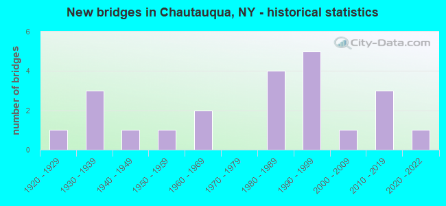
- New bridges - historical statistics
- 11920-1929
- 31930-1939
- 11940-1949
- 11950-1959
- 21960-1969
- 41980-1989
- 51990-1999
- 12000-2009
- 32010-2019
- 12020-2022

- Reconstructed bridges - Historical Statistics
- 31980-1989
- 11990-1999
- 12000-2009
- 22010-2019


- Bridge Condition - Deck
- 26.3%Excellent
- 26.3%Very good
- 26.3%Good
- 10.5%Satisfactory
- 10.5%Fair

- Bridge Condition - Superstructure
- 26.3%Excellent
- 42.1%Very good
- 21.1%Good
- 5.3%Satisfactory
- 5.3%Poor

- Bridge Condition - Substructure
- 10.5%Excellent
- 26.3%Very good
- 15.8%Good
- 26.3%Satisfactory
- 21.1%Fair

- Bridge Condition - Channel
- 4.5%Excellent
- 13.6%Very good
- 9.1%Good
- 40.9%Satisfactory
- 27.3%Fair
- 4.5%Poor

- Bridge Condition - Culverts
- 33.3%Good
- 66.7%Satisfactory
Find on map >> Show street view
Structure Number: 101203, Location: 1.8 MI NE JCT RTS 17 +430 (Lat: 42.265533, Lng: -79.475808), Route carried "on" structure: State highway 430, Year Built: 1938, Year Reconstructed: 1992, Status: Open, Structure Length: 1.98m (6.50ft), Average Daily Traffic: 3,310 (year 2017), Truck Traffic: 6%, Average Future Daily Traffic: 3,343 (year 2040), Features Intersected: BIG INLET
Minimum Vertical Clearance: 30+ m (98+ ft), Kilometerpoint: 32.759, Lanes on structure: 2, Base Highway Network: Yes, Owner: State Highway Agency, Approaching Roadway Width: 10.4m (34.1ft), Material/Design: Steel, Design/Construction: Girder and Floorbeam System, Number Of Spans In Main Unit: 1, Length of Maximum Span: 18.2m (59.7ft), Curb-To-Curb Width: 10.4m (34.1ft), Out-to-Out Width: 11.4m (37.4ft)
Condition: Deck: Satisfactory, Superstructure: Poor, Substructure: Satisfactory, Channel: Good, Operating Rating: 52.6 metric tons, Method Used To Determine Operating Rating: Load Factor (LF), Inventory Rating: 20.9 metric tons, Method Used To Determine Inventory Rating: Load Factor (LF), Structural Evaluation: Meets minimum limits, Deck Geometry: Somewhat better than minimum adequacy, Waterway Adequacy: Somewhat better than minimum adequacy, Approach Roadway Alignment: Equal to present desirable criteria, Length Of Structure Improvement: 1.98m (6.50ft), Designated Inspection Frequency: Every 24 months, Critical Feature Inspection Frequency: Every 24 months, Inspection Date: September 2020, Critical Feature Inspection Date: September 2020, Bridge Improvement Cost: $1,424,000, Roadway Improvement Cost: $834,000, Total Project Cost: $2,257,000 ( Estimate for 2021), Deck Structure Type: Concrete Cast-file-Place, Wearing Surface/Protective System: Wearing Surface: Integral Concrete, Deck Protection: Epoxy Coated Reinforcing
Find on map >> Show street view
Structure Number: 101204, Location: 4.7 MI SE JCT RTS 17 +430 (Lat: 42.236247, Lng: -79.443119), Route carried "on" structure: State highway 430, Year Built: 2021, Status: Open, Structure Length: 3.08m (10.10ft), Average Daily Traffic: 3,310 (year 2017), Truck Traffic: 6%, Average Future Daily Traffic: 3,343 (year 2040), Features Intersected: DEWITTVILLE CREEK
Minimum Vertical Clearance: 30+ m (98+ ft), Kilometerpoint: 37.264, Lanes on structure: 2, Base Highway Network: Yes, Owner: State Highway Agency, Approaching Roadway Width: 10.4m (34.1ft), Skew: 2 degrees, Material/Design: Steel, Design/Construction: Stringer/Multi-beam, Number Of Spans In Main Unit: 1, Length of Maximum Span: 30.5m (100.1ft), Curb-To-Curb Width: 10.4m (34.1ft), Out-to-Out Width: 11.6m (38.1ft)
Condition: Deck: Excellent, Superstructure: Excellent, Substructure: Excellent, Channel: Excellent, Operating Rating: 86.2 metric tons, Method Used To Determine Operating Rating: Load Factor (LF), Inventory Rating: 51.7 metric tons, Method Used To Determine Inventory Rating: Load Factor (LF), Structural Evaluation: Superior to present desirable criteria, Deck Geometry: Somewhat better than minimum adequacy, Waterway Adequacy: Meets minimum limits, Approach Roadway Alignment: Equal to present desirable criteria, Length Of Structure Improvement: 1.98m (6.50ft), Designated Inspection Frequency: Every 24 months, Inspection Date: November 2021, Bridge Improvement Cost: $1,147,000, Roadway Improvement Cost: $672,000, Total Project Cost: $1,819,000 ( Estimate for 2021), Deck Structure Type: Concrete Cast-file-Place, Wearing Surface/Protective System: Wearing Surface: Integral Concrete, Deck Protection: Epoxy Coated Reinforcing
Find on map >> Show street view
Structure Number: 101443, Location: 3 MI NW JCT SH17 & SH394 (Lat: 42.188728, Lng: -79.452272), Route carried "on" structure: State highway 394, Year Built: 1962, Year Reconstructed: 2003, Status: Open, Structure Length: 2.29m (7.51ft), Average Daily Traffic: 3,140 (year 2018), Truck Traffic: 4%, Average Future Daily Traffic: 3,312 (year 2040), Design Load: HS 20+Mod, Features Intersected: PRENDERGAST CREEK
Minimum Vertical Clearance: 30+ m (98+ ft), Kilometerpoint: 21.754, Lanes on structure: 2, Base Highway Network: Yes, Owner: State Highway Agency, Approaching Roadway Width: 11.0m (36.1ft), Material/Design: Prestressed concrete, Design/Construction: Box Beam or Girders - Multiple, Number Of Spans In Main Unit: 1, Length of Maximum Span: 21.9m (71.9ft), Curb-To-Curb Width: 10.9m (35.8ft), Out-to-Out Width: 11.3m (37.1ft)
Condition: Deck: Good, Superstructure: Very good, Substructure: Very good, Channel: Very good, Operating Rating: 71.7 metric tons, Method Used To Determine Operating Rating: Load Factor (LF), Inventory Rating: 44.5 metric tons, Method Used To Determine Inventory Rating: Load Factor (LF), Structural Evaluation: Equal to present desirable criteria, Deck Geometry: Somewhat better than minimum adequacy, Waterway Adequacy: Equal to present minimum criteria, Approach Roadway Alignment: Somewhat better than minimum adequacy, Length Of Structure Improvement: 2.28m (7.48ft), Designated Inspection Frequency: Every 24 months, Inspection Date: November 2020, Bridge Improvement Cost: $995,000, Roadway Improvement Cost: $582,000, Total Project Cost: $1,577,000 ( Estimate for 2021), Wearing Surface/Protective System: Wearing Surface: Monolithic Concrete
Find on map >> Show street view
Structure Number: 101444, Location: 2.4 MI S JCT 394 & 430 (Lat: 42.226219, Lng: -79.488150), Route carried "on" structure: State highway 394, Year Built: 2004, Status: Open, Structure Length: 1.16m (3.81ft), Average Daily Traffic: 5,323 (year 2020), Truck Traffic: 4%, Average Future Daily Traffic: 5,614 (year 2040), Design Load: HS 25 or greater, Features Intersected: CLEAR CREEK
Minimum Vertical Clearance: 30+ m (98+ ft), Kilometerpoint: 16.412, Lanes on structure: 2, Base Highway Network: Yes, Owner: State Highway Agency, Approaching Roadway Width: 11.3m (37.1ft), Skew: 2 degrees, Material/Design: Concrete, Design/Construction: Culvert, Number Of Spans In Main Unit: 1, Length of Maximum Span: 11.0m (36.1ft), Curb-To-Curb Width: 11.4m (37.4ft), Out-to-Out Width: 12.4m (40.7ft)
Condition: Channel: Very good, Culverts: Satisfactory, Operating Rating: 75.3 metric tons, Method Used To Determine Operating Rating: Load Factor (LF), Inventory Rating: 45.4 metric tons, Method Used To Determine Inventory Rating: Load Factor (LF), Structural Evaluation: Equal to present minimum criteria, Deck Geometry: Meets minimum limits, Waterway Adequacy: Equal to present minimum criteria, Approach Roadway Alignment: Equal to present desirable criteria, Length Of Structure Improvement: 1.15m (3.77ft), Designated Inspection Frequency: Every 24 months, Inspection Date: June 2021, Bridge Improvement Cost: $397,000, Roadway Improvement Cost: $233,000, Total Project Cost: $630,000 ( Estimate for 2021), Wearing Surface/Protective System: Wearing Surface: Bituminous, Membrane: Other
Find on map >> Show street view
Structure Number: 104848, Location: 0.8 MI SW MAYVILLE (Lat: 42.246700, Lng: -79.514908), Route carried "on" structure: State highway 430, Year Built: 1997, Status: Open, Structure Length: 1.46m (4.79ft), Average Daily Traffic: 1,341 (year 2020), Truck Traffic: 7%, Average Future Daily Traffic: 1,354 (year 2040), Design Load: HS 25 or greater, Features Intersected: MUD CREEK
Minimum Vertical Clearance: 30+ m (98+ ft), Kilometerpoint: 28.624, Lanes on structure: 2, Base Highway Network: Yes, Owner: State Highway Agency, Approaching Roadway Width: 10.4m (34.1ft), Material/Design: Prestressed concrete, Design/Construction: Box Beam or Girders - Multiple, Number Of Spans In Main Unit: 1, Length of Maximum Span: 13.4m (44.0ft), Curb-To-Curb Width: 10.4m (34.1ft), Out-to-Out Width: 11.0m (36.1ft)
Condition: Deck: Good, Superstructure: Very good, Substructure: Good, Channel: Very good, Operating Rating: 89.8 metric tons, Method Used To Determine Operating Rating: Load Factor (LF), Inventory Rating: 41.7 metric tons, Method Used To Determine Inventory Rating: Load Factor (LF), Structural Evaluation: Better than present minimum criteria, Deck Geometry: Equal to present minimum criteria, Waterway Adequacy: Somewhat better than minimum adequacy, Approach Roadway Alignment: Equal to present desirable criteria, Length Of Structure Improvement: 1.46m (4.79ft), Designated Inspection Frequency: Every 24 months, Inspection Date: June 2021, Bridge Improvement Cost: $415,000, Roadway Improvement Cost: $243,000, Total Project Cost: $659,000 ( Estimate for 2021), Wearing Surface/Protective System: Wearing Surface: Integral Concrete
Find on map >> Show street view
Structure Number: 221232, Location: 2.3 MI E OF HARTFIELD (Lat: 42.267633, Lng: -79.429008), Route carried "on" structure: Other road , Year Built: 1981, Year Reconstructed: 2010, Status: Open, Structure Length: 0.82m (2.69ft), Average Daily Traffic: 127 (year 2018), Truck Traffic: 5%, Average Future Daily Traffic: 178 (year 2038), Features Intersected: DEWITTVILLE CREEK, Facility Carried by Structure: MEADOWS ROAD
Minimum Vertical Clearance: 30+ m (98+ ft), Kilometerpoint: 4.167, Lanes on structure: 2, Owner: County Highway Agency, Approaching Roadway Width: 5.5m (18.0ft), Material/Design: Steel, Design/Construction: Stringer/Multi-beam, Number Of Spans In Main Unit: 1, Length of Maximum Span: 7.9m (25.9ft), Curb-To-Curb Width: 7.2m (23.6ft), Out-to-Out Width: 7.8m (25.6ft)
Condition: Deck: Excellent, Superstructure: Excellent, Substructure: Satisfactory, Channel: Fair, Inventory Rating: 84.4 metric tons, Method Used To Determine Inventory Rating: Load Factor (LF), Structural Evaluation: Equal to present minimum criteria, Deck Geometry: Meets minimum limits, Waterway Adequacy: Meets minimum limits, Approach Roadway Alignment: Better than present minimum criteria, Length Of Structure Improvement: 0.82m (2.69ft), Designated Inspection Frequency: Every 24 months, Inspection Date: November 2020, Bridge Improvement Cost: $1,007,000, Roadway Improvement Cost: $590,000, Total Project Cost: $1,597,000 ( Estimate for 2021), Deck Structure Type: Corrugated Steel, Wearing Surface/Protective System: Wearing Surface: Bituminous
Find on map >> Show street view
Structure Number: 221233, Location: 1.1 MI NW OF STEDMAN (Lat: 42.183767, Lng: -79.484583), Route carried "on" structure: Other road , Year Built: 1993, Status: Open, Structure Length: 1.49m (4.89ft), Average Daily Traffic: 184 (year 2018), Truck Traffic: 5%, Average Future Daily Traffic: 258 (year 2038), Design Load: HS 25 or greater, Features Intersected: PRENDERGAST CREEK, Facility Carried by Structure: WEBBER ROAD
Minimum Vertical Clearance: 30+ m (98+ ft), Kilometerpoint: 3.427, Lanes on structure: 2, Owner: County Highway Agency, Approaching Roadway Width: 5.5m (18.0ft), Skew: 4 degrees, Material/Design: Prestressed concrete, Design/Construction: Stringer/Multi-beam, Number Of Spans In Main Unit: 1, Length of Maximum Span: 13.7m (44.9ft), Curb-To-Curb Width: 7.9m (25.9ft), Out-to-Out Width: 8.6m (28.2ft)
Condition: Deck: Very good, Superstructure: Very good, Substructure: Satisfactory, Channel: Fair, Operating Rating: 58.0 metric tons, Method Used To Determine Operating Rating: Load and Resistance Factor Rating (LRFR) rating reported by rating factor(RF) method using HL-93 loadings, Inventory Rating: 43.1 metric tons, Method Used To Determine Inventory Rating: Load and Resistance Factor Rating (LRFR) rating reported by rating factor(RF) method using HL-93 loadings, Structural Evaluation: Equal to present minimum criteria, Deck Geometry: Somewhat better than minimum adequacy, Waterway Adequacy: Equal to present desirable criteria, Approach Roadway Alignment: Equal to present desirable criteria, Length Of Structure Improvement: 1.49m (4.89ft), Designated Inspection Frequency: Every 24 months, Inspection Date: April 2020, Bridge Improvement Cost: $1,159,000, Roadway Improvement Cost: $678,000, Total Project Cost: $1,837,000 ( Estimate for 2021), Wearing Surface/Protective System: Wearing Surface: Bituminous, Membrane: Preformed Fabric
Find on map >> Show street view
Structure Number: 226711, Location: 2.3 MI SE OF SUMMERDALE (Lat: 42.200756, Lng: -79.527911), Route carried "on" structure: Other road , Year Built: 1988, Status: Open, Structure Length: 0.67m (2.20ft), Average Daily Traffic: 134 (year 2018), Truck Traffic: 5%, Average Future Daily Traffic: 188 (year 2038), Design Load: HS 20, Features Intersected: WING CREEK, Facility Carried by Structure: MT. PLEASANT ROAD
Minimum Vertical Clearance: 30+ m (98+ ft), Kilometerpoint: 3.749, Lanes on structure: 2, Owner: County Highway Agency, Approaching Roadway Width: 6.7m (22.0ft), Material/Design: Aluminum, Iron, Design/Construction: Culvert, Number Of Spans In Main Unit: 1, Length of Maximum Span: 6.4m (21.0ft)
Condition: Channel: Satisfactory, Culverts: Satisfactory, Operating Rating: 76.7 metric tons, Method Used To Determine Operating Rating: Field evaluation and documented engineering judgment, Inventory Rating: 29.4 metric tons, Method Used To Determine Inventory Rating: Field evaluation and documented engineering judgment, Structural Evaluation: Equal to present minimum criteria, Waterway Adequacy: Meets minimum limits, Approach Roadway Alignment: Better than present minimum criteria, Length Of Structure Improvement: 0.67m (2.20ft), Designated Inspection Frequency: Every 24 months, Inspection Date: March 2021, Bridge Improvement Cost: $124,000, Roadway Improvement Cost: $73,000, Total Project Cost: $197,000 ( Estimate for 2021)
Find on map >> Show street view
Structure Number: 332391, Location: AT DEWITTVILLE (Lat: 42.239119, Lng: -79.443325), Route carried "on" structure: County highway , Year Built: 1990, Status: Open, Structure Length: 2.38m (7.81ft), Average Daily Traffic: 153 (year 2017), Truck Traffic: 10%, Average Future Daily Traffic: 214 (year 2037), Design Load: HS 20, Features Intersected: DEWITTVILLE CREEK, Facility Carried by Structure: COUNTY ROAD 314
Minimum Vertical Clearance: 30+ m (98+ ft), Kilometerpoint: 0.515, Lanes on structure: 2, Owner: County Highway Agency, Approaching Roadway Width: 7.3m (24.0ft), Material/Design: Prestressed concrete, Design/Construction: Box Beam or Girders - Multiple, Number Of Spans In Main Unit: 1, Length of Maximum Span: 23.4m (76.8ft), Curb-To-Curb Width: 7.3m (24.0ft), Out-to-Out Width: 7.9m (25.9ft)
Condition: Deck: Good, Superstructure: Very good, Substructure: Very good, Channel: Poor, Operating Rating: 64.8 metric tons, Method Used To Determine Operating Rating: Load and Resistance Factor Rating (LRFR) rating reported by rating factor(RF) method using HL-93 loadings, Inventory Rating: 45.7 metric tons, Method Used To Determine Inventory Rating: Load and Resistance Factor Rating (LRFR) rating reported by rating factor(RF) method using HL-93 loadings, Structural Evaluation: Equal to present desirable criteria, Deck Geometry: Somewhat better than minimum adequacy, Waterway Adequacy: Equal to present desirable criteria, Approach Roadway Alignment: Equal to present desirable criteria, Length Of Structure Improvement: 2.37m (7.78ft), Designated Inspection Frequency: Every 24 months, Inspection Date: May 2020, Bridge Improvement Cost: $540,000, Roadway Improvement Cost: $316,000, Total Project Cost: $856,000 ( Estimate for 2021), Deck Structure Type: Concrete Cast-file-Place, Wearing Surface/Protective System: Wearing Surface: Bituminous, Deck Protection: Epoxy Coated Reinforcing
Find on map >> Show street view
Structure Number: 332392, Location: 2.1 MI E OF HARTFIELD (Lat: 42.260875, Lng: -79.432103), Route carried "on" structure: County highway , Year Built: 1931, Year Reconstructed: 1986, Status: Open, Structure Length: 1.25m (4.10ft), Average Daily Traffic: 494 (year 2018), Truck Traffic: 11%, Average Future Daily Traffic: 692 (year 2038), Design Load: HS 20, Features Intersected: DEWITTVILLE CREEK, Facility Carried by Structure: CENTRALIA ROAD
Minimum Vertical Clearance: 30+ m (98+ ft), Kilometerpoint: 3.427, Lanes on structure: 2, Owner: County Highway Agency, Approaching Roadway Width: 7.3m (24.0ft), Material/Design: Prestressed concrete, Design/Construction: Box Beam or Girders - Multiple, Number Of Spans In Main Unit: 1, Length of Maximum Span: 11.8m (38.7ft), Curb-To-Curb Width: 9.1m (29.9ft), Out-to-Out Width: 9.8m (32.2ft)
Condition: Deck: Satisfactory, Superstructure: Good, Substructure: Good, Channel: Satisfactory, Operating Rating: 50.9 metric tons, Method Used To Determine Operating Rating: Load and Resistance Factor Rating (LRFR) rating reported by rating factor(RF) method using HL-93 loadings, Inventory Rating: 28.8 metric tons, Method Used To Determine Inventory Rating: Load and Resistance Factor Rating (LRFR) rating reported by rating factor(RF) method using HL-93 loadings, Structural Evaluation: Better than present minimum criteria, Deck Geometry: Equal to present minimum criteria, Waterway Adequacy: Somewhat better than minimum adequacy, Approach Roadway Alignment: Equal to present minimum criteria, Length Of Structure Improvement: 1.24m (4.07ft), Designated Inspection Frequency: Every 24 months, Inspection Date: March 2021, Bridge Improvement Cost: $540,000, Roadway Improvement Cost: $316,000, Total Project Cost: $857,000 ( Estimate for 2021), Wearing Surface/Protective System: Wearing Surface: Bituminous, Membrane: Other
Find on map >> Show street view
Structure Number: 332393, Location: 1.4 MI SW OF SUMMERDALE (Lat: 42.203792, Lng: -79.589247), Route carried "on" structure: County highway , Year Built: 1956, Year Reconstructed: 2019, Status: Open, Structure Length: 1.10m (3.61ft), Average Daily Traffic: 160 (year 2020), Truck Traffic: 7%, Average Future Daily Traffic: 224 (year 2040), Features Intersected: BR CHAUTAUQUA CRK, Facility Carried by Structure: NETTLE HILL ROAD
Minimum Vertical Clearance: 30+ m (98+ ft), Kilometerpoint: 3.588, Lanes on structure: 2, Owner: County Highway Agency, Approaching Roadway Width: 6.4m (21.0ft), Material/Design: Steel, Design/Construction: Stringer/Multi-beam, Number Of Spans In Main Unit: 1, Length of Maximum Span: 10.4m (34.1ft), Curb-To-Curb Width: 8.2m (26.9ft), Out-to-Out Width: 8.5m (27.9ft)
Condition: Deck: Fair, Superstructure: Satisfactory, Substructure: Fair, Channel: Fair, Operating Rating: 42.6 metric tons, Method Used To Determine Operating Rating: Load Factor (LF), Inventory Rating: 25.4 metric tons, Method Used To Determine Inventory Rating: Load Factor (LF), Structural Evaluation: Somewhat better than minimum adequacy, Deck Geometry: Somewhat better than minimum adequacy, Waterway Adequacy: Meets minimum limits, Approach Roadway Alignment: Equal to present minimum criteria, Length Of Structure Improvement: 1.09m (3.58ft), Designated Inspection Frequency: Every 24 months, Inspection Date: April 2021, Bridge Improvement Cost: $670,000, Roadway Improvement Cost: $392,000, Total Project Cost: $1,062,000 ( Estimate for 2021), Deck Structure Type: Concrete Precast Panels, Wearing Surface/Protective System: Wearing Surface: Bituminous
Find on map >> Show street view
Structure Number: 332394, Location: IN HARTFIELD (Lat: 42.268014, Lng: -79.475789), Route carried "on" structure: County highway , Year Built: 1990, Status: Open, Structure Length: 2.44m (8.01ft), Average Daily Traffic: 2,387 (year 2020), Truck Traffic: 8%, Average Future Daily Traffic: 2,410 (year 2040), Design Load: HS 20, Features Intersected: BIG INLET CREEK, Facility Carried by Structure: COUNTY ROAD 127
Minimum Vertical Clearance: 32.69m (107.25ft), Kilometerpoint: 0.467, Lanes on structure: 2, Owner: County Highway Agency, Approaching Roadway Width: 9.8m (32.2ft), Skew: 1 degrees, Material/Design: Prestressed concrete, Design/Construction: Box Beam or Girders - Multiple, Number Of Spans In Main Unit: 1, Length of Maximum Span: 23.1m (75.8ft), Curb-To-Curb Width: 9.8m (32.2ft), Out-to-Out Width: 10.6m (34.8ft)
Condition: Deck: Good, Superstructure: Good, Substructure: Good, Channel: Satisfactory, Operating Rating: 89.8 metric tons, Method Used To Determine Operating Rating: Load Factor (LF), Inventory Rating: 35.4 metric tons, Method Used To Determine Inventory Rating: Load Factor (LF), Structural Evaluation: Better than present minimum criteria, Deck Geometry: Meets minimum limits, Waterway Adequacy: Meets minimum limits, Approach Roadway Alignment: Equal to present desirable criteria, Length Of Structure Improvement: 2.43m (7.97ft), Designated Inspection Frequency: Every 24 months, Inspection Date: May 2020, Bridge Improvement Cost: $764,000, Roadway Improvement Cost: $448,000, Total Project Cost: $1,212,000 ( Estimate for 2021), Deck Structure Type: Concrete Cast-file-Place, Wearing Surface/Protective System: Wearing Surface: Bituminous
Find on map >> Show street view
Structure Number: 332395, Location: 1.2 MI NORTH OF STEDMAN (Lat: 42.186775, Lng: -79.478281), Route carried "on" structure: County highway , Year Built: 1989, Status: Open, Structure Length: 2.90m (9.51ft), Average Daily Traffic: 885 (year 2018), Truck Traffic: 15%, Average Future Daily Traffic: 893 (year 2040), Design Load: HS 20, Features Intersected: PRENDERGAST CREEK, Facility Carried by Structure: COUNTY ROAD 33
Minimum Vertical Clearance: 30+ m (98+ ft), Kilometerpoint: 3.443, Lanes on structure: 2, Owner: County Highway Agency, Approaching Roadway Width: 9.1m (29.9ft), Skew: 1 degrees, Material/Design: Prestressed concrete, Design/Construction: Box Beam or Girders - Multiple, Number Of Spans In Main Unit: 1, Length of Maximum Span: 28.6m (93.8ft), Curb-To-Curb Width: 9.4m (30.8ft), Out-to-Out Width: 9.8m (32.2ft)
Condition: Deck: Fair, Superstructure: Good, Substructure: Fair, Channel: Satisfactory, Operating Rating: 65.4 metric tons, Method Used To Determine Operating Rating: Load and Resistance Factor Rating (LRFR) rating reported by rating factor(RF) method using HL-93 loadings, Inventory Rating: 29.8 metric tons, Method Used To Determine Inventory Rating: Load and Resistance Factor Rating (LRFR) rating reported by rating factor(RF) method using HL-93 loadings, Structural Evaluation: Somewhat better than minimum adequacy, Deck Geometry: Equal to present minimum criteria, Waterway Adequacy: Meets minimum limits, Approach Roadway Alignment: Equal to present desirable criteria, Length Of Structure Improvement: 2.89m (9.48ft), Designated Inspection Frequency: Every 24 months, Inspection Date: April 2021, Bridge Improvement Cost: $843,000, Roadway Improvement Cost: $493,000, Total Project Cost: $1,336,000 ( Estimate for 2021), Deck Structure Type: Concrete Cast-file-Place, Wearing Surface/Protective System: Wearing Surface: Integral Concrete, Deck Protection: Epoxy Coated Reinforcing
Find on map >> Show street view
Structure Number: 332396, Location: 2.1 MI E OF HARTFIELD (Lat: 42.256894, Lng: -79.434606), Route carried "on" structure: Other road , Year Built: 1925, Year Reconstructed: 2008, Status: Open, Structure Length: 1.49m (4.89ft), Average Daily Traffic: 168 (year 2018), Truck Traffic: 5%, Average Future Daily Traffic: 235 (year 2038), Design Load: HS 25 or greater, Features Intersected: DEWITTVILLE CREEK, Facility Carried by Structure: MEADOWS ROAD
Minimum Vertical Clearance: 30+ m (98+ ft), Kilometerpoint: 2.864, Lanes on structure: 2, Owner: County Highway Agency, Approaching Roadway Width: 6.4m (21.0ft), Material/Design: Prestressed concrete, Design/Construction: Box Beam or Girders - Multiple, Number Of Spans In Main Unit: 1, Length of Maximum Span: 13.7m (44.9ft), Curb-To-Curb Width: 7.9m (25.9ft), Out-to-Out Width: 8.7m (28.5ft)
Condition: Deck: Very good, Superstructure: Very good, Substructure: Fair, Channel: Fair, Operating Rating: 84.4 metric tons, Method Used To Determine Operating Rating: Load Factor (LF), Inventory Rating: 49.9 metric tons, Method Used To Determine Inventory Rating: Load Factor (LF), Structural Evaluation: Somewhat better than minimum adequacy, Deck Geometry: Somewhat better than minimum adequacy, Waterway Adequacy: Meets minimum limits, Approach Roadway Alignment: Equal to present desirable criteria, Length Of Structure Improvement: 1.49m (4.89ft), Designated Inspection Frequency: Every 24 months, Inspection Date: March 2021, Bridge Improvement Cost: $554,000, Roadway Improvement Cost: $324,000, Total Project Cost: $878,000 ( Estimate for 2021), Wearing Surface/Protective System: Wearing Surface: Bituminous, Membrane: Other
Find on map >> Show street view
Structure Number: 332397, Location: 1.2 MI NW OF CHAUTAUQUA (Lat: 42.221972, Lng: -79.493044), Route carried "on" structure: Other road , Year Built: 2012, Status: Open, Structure Length: 0.98m (3.22ft), Average Daily Traffic: 169 (year 2019), Truck Traffic: 5%, Average Future Daily Traffic: 237 (year 2039), Design Load: HS 25 or greater, Features Intersected: TRB CHAUTAUQUA LK, Facility Carried by Structure: MOORE ROAD
Minimum Vertical Clearance: 30+ m (98+ ft), Kilometerpoint: 2.060, Lanes on structure: 2, Owner: County Highway Agency, Approaching Roadway Width: 6.1m (20.0ft), Skew: 1 degrees, Material/Design: Prestressed concrete, Design/Construction: Box Beam or Girders - Multiple, Number Of Spans In Main Unit: 1, Length of Maximum Span: 9.4m (30.8ft), Curb-To-Curb Width: 6.6m (21.7ft), Out-to-Out Width: 7.4m (24.3ft)
Condition: Deck: Excellent, Superstructure: Excellent, Substructure: Excellent, Channel: Satisfactory, Operating Rating: 52.8 metric tons, Method Used To Determine Operating Rating: Load and Resistance Factor Rating (LRFR) rating reported by rating factor(RF) method using HL-93 loadings, Inventory Rating: 40.8 metric tons, Method Used To Determine Inventory Rating: Load and Resistance Factor Rating (LRFR) rating reported by rating factor(RF) method using HL-93 loadings, Structural Evaluation: Superior to present desirable criteria, Deck Geometry: Meets minimum limits, Waterway Adequacy: Meets minimum limits, Approach Roadway Alignment: Equal to present desirable criteria, Length Of Structure Improvement: 0.97m (3.18ft), Designated Inspection Frequency: Every 24 months, Inspection Date: October 2020, Bridge Improvement Cost: $640,000, Roadway Improvement Cost: $375,000, Total Project Cost: $1,015,000 ( Estimate for 2021), Wearing Surface/Protective System: Wearing Surface: Bituminous
Find on map >> Show street view
Structure Number: 332398, Location: 3 MI N OF HARTFIED (Lat: 42.310047, Lng: -79.481614), Route carried "on" structure: County highway , Year Built: 1992, Status: Open, Structure Length: 1.16m (3.81ft), Average Daily Traffic: 56 (year 2018), Truck Traffic: 7%, Average Future Daily Traffic: 78 (year 2038), Design Load: HS 20, Features Intersected: BIG INLET CREEK, Facility Carried by Structure: ELM FLAT ROAD
Minimum Vertical Clearance: 30+ m (98+ ft), Kilometerpoint: 5.374, Lanes on structure: 2, Owner: County Highway Agency, Approaching Roadway Width: 7.3m (24.0ft), Material/Design: Prestressed concrete, Design/Construction: Box Beam or Girders - Multiple, Number Of Spans In Main Unit: 1, Length of Maximum Span: 10.9m (35.8ft), Curb-To-Curb Width: 7.3m (24.0ft), Out-to-Out Width: 8.6m (28.2ft)
Condition: Deck: Very good, Superstructure: Very good, Substructure: Very good, Channel: Satisfactory, Operating Rating: 54.4 metric tons, Method Used To Determine Operating Rating: Load Factor (LF), Inventory Rating: 32.7 metric tons, Method Used To Determine Inventory Rating: Load Factor (LF), Structural Evaluation: Equal to present desirable criteria, Deck Geometry: Equal to present minimum criteria, Waterway Adequacy: Meets minimum limits, Approach Roadway Alignment: Equal to present desirable criteria, Length Of Structure Improvement: 1.15m (3.77ft), Designated Inspection Frequency: Every 24 months, Inspection Date: July 2020, Bridge Improvement Cost: $882,000, Roadway Improvement Cost: $516,000, Total Project Cost: $1,398,000 ( Estimate for 2021), Wearing Surface/Protective System: Wearing Surface: Bituminous
Find on map >> Show street view
Structure Number: 332399, Location: 1.1 MILES S OF MAYVILLE (Lat: 42.220097, Lng: -79.497178), Route carried "on" structure: Other road , Year Built: 1946, Year Reconstructed: 1988, Status: Open, Structure Length: 0.94m (3.08ft), Average Daily Traffic: 169 (year 2019), Truck Traffic: 5%, Average Future Daily Traffic: 237 (year 2039), Features Intersected: TRB CHAUTAUQUA LK, Facility Carried by Structure: MOORE ROAD
Minimum Vertical Clearance: 30+ m (98+ ft), Kilometerpoint: 1.657, Lanes on structure: 2, Owner: County Highway Agency, Approaching Roadway Width: 5.5m (18.0ft), Skew: 1 degrees, Material/Design: Steel, Design/Construction: Stringer/Multi-beam, Number Of Spans In Main Unit: 1, Length of Maximum Span: 8.8m (28.9ft), Curb-To-Curb Width: 6.5m (21.3ft), Out-to-Out Width: 6.9m (22.6ft)
Condition: Deck: Very good, Superstructure: Very good, Substructure: Satisfactory, Channel: Fair, Operating Rating: 41.5 metric tons, Method Used To Determine Operating Rating: Load and Resistance Factor Rating (LRFR) rating reported by rating factor(RF) method using HL-93 loadings, Inventory Rating: 32.1 metric tons, Method Used To Determine Inventory Rating: Load and Resistance Factor Rating (LRFR) rating reported by rating factor(RF) method using HL-93 loadings, Structural Evaluation: Equal to present minimum criteria, Deck Geometry: Meets minimum limits, Waterway Adequacy: Equal to present minimum criteria, Approach Roadway Alignment: Equal to present desirable criteria, Length Of Structure Improvement: 0.94m (3.08ft), Designated Inspection Frequency: Every 24 months, Inspection Date: March 2021, Bridge Improvement Cost: $952,000, Roadway Improvement Cost: $558,000, Total Project Cost: $1,510,000 ( Estimate for 2021), Deck Structure Type: Concrete Precast Panels, Wearing Surface/Protective System: Wearing Surface: Bituminous
Find on map >> Show street view
Structure Number: 332401, Location: 2.4 MILES NW OF STEDMAN (Lat: 42.193642, Lng: -79.510703), Route carried "on" structure: Other road , Year Built: 1965, Status: Open, Structure Length: 1.22m (4.00ft), Average Daily Traffic: 49 (year 2018), Truck Traffic: 2%, Average Future Daily Traffic: 69 (year 2038), Features Intersected: WING CREEK, Facility Carried by Structure: HEWES ROAD
Minimum Vertical Clearance: 30+ m (98+ ft), Kilometerpoint: 2.301, Lanes on structure: 2, Owner: County Highway Agency, Approaching Roadway Width: 4.6m (15.1ft), Material/Design: Steel continuous, Design/Construction: Stringer/Multi-beam, Number Of Spans In Main Unit: 2, Length of Maximum Span: 5.8m (19.0ft), Curb-To-Curb Width: 5.8m (19.0ft), Out-to-Out Width: 6.1m (20.0ft)
Condition: Deck: Good, Superstructure: Good, Substructure: Fair, Channel: Fair, Operating Rating: 78.9 metric tons, Method Used To Determine Operating Rating: Load Factor (LF), Inventory Rating: 47.2 metric tons, Method Used To Determine Inventory Rating: Load Factor (LF), Structural Evaluation: Somewhat better than minimum adequacy, Deck Geometry: Meets minimum limits, Waterway Adequacy: Better than present minimum criteria, Approach Roadway Alignment: Equal to present desirable criteria, Length Of Structure Improvement: 1.21m (3.97ft), Designated Inspection Frequency: Every 24 months, Inspection Date: April 2021, Bridge Improvement Cost: $646,000, Roadway Improvement Cost: $378,000, Total Project Cost: $1,024,000 ( Estimate for 2021), Deck Structure Type: Concrete Cast-file-Place, Wearing Surface/Protective System: Wearing Surface: Bituminous
Find on map >> Show street view
Structure Number: 332402, Location: 3.9 MI SW OF RTE 394 (Lat: 42.190489, Lng: -79.497908), Route carried "on" structure: County highway , Year Built: 1989, Status: Open, Structure Length: 1.58m (5.18ft), Average Daily Traffic: 103 (year 2018), Truck Traffic: 5%, Average Future Daily Traffic: 144 (year 2038), Design Load: HS 20, Features Intersected: WING CREEK, Facility Carried by Structure: POTTER ROAD
Minimum Vertical Clearance: 30+ m (98+ ft), Kilometerpoint: 1.979, Lanes on structure: 2, Owner: County Highway Agency, Approaching Roadway Width: 9.1m (29.9ft), Material/Design: Prestressed concrete, Design/Construction: Box Beam or Girders - Multiple, Number Of Spans In Main Unit: 1, Length of Maximum Span: 15.5m (50.9ft), Curb-To-Curb Width: 9.2m (30.2ft), Out-to-Out Width: 9.9m (32.5ft)
Condition: Deck: Very good, Superstructure: Very good, Substructure: Satisfactory, Channel: Satisfactory, Operating Rating: 59.9 metric tons, Method Used To Determine Operating Rating: Load Factor (LF), Inventory Rating: 22.7 metric tons, Method Used To Determine Inventory Rating: Load Factor (LF), Structural Evaluation: Equal to present minimum criteria, Deck Geometry: Equal to present minimum criteria, Waterway Adequacy: Equal to present desirable criteria, Approach Roadway Alignment: Meets minimum limits, Length Of Structure Improvement: 1.58m (5.18ft), Designated Inspection Frequency: Every 24 months, Inspection Date: April 2021, Bridge Improvement Cost: $912,000, Roadway Improvement Cost: $534,000, Total Project Cost: $1,447,000 ( Estimate for 2021), Wearing Surface/Protective System: Wearing Surface: Bituminous
Find on map >> Show street view
Structure Number: 332405, Location: 3.0 MI S OF MAYVILLE (Lat: 42.199319, Lng: -79.526031), Route carried "on" structure: County highway , Year Built: 2013, Status: Open, Structure Length: 1.40m (4.59ft), Average Daily Traffic: 178 (year 2018), Truck Traffic: 9%, Average Future Daily Traffic: 249 (year 2038), Design Load: HS 25 or greater, Features Intersected: WING CREEK, Facility Carried by Structure: TOWN LINE ROAD
Minimum Vertical Clearance: 30+ m (98+ ft), Kilometerpoint: 4.055, Lanes on structure: 2, Owner: County Highway Agency, Approaching Roadway Width: 8.8m (28.9ft), Material/Design: Prestressed concrete, Design/Construction: Box Beam or Girders - Multiple, Number Of Spans In Main Unit: 1, Length of Maximum Span: 13.1m (43.0ft), Curb-To-Curb Width: 9.0m (29.5ft), Out-to-Out Width: 9.8m (32.2ft)
Condition: Deck: Excellent, Superstructure: Excellent, Substructure: Very good, Channel: Good, Operating Rating: 69.9 metric tons, Method Used To Determine Operating Rating: Load Factor (LF), Inventory Rating: 53.5 metric tons, Method Used To Determine Inventory Rating: Load Factor (LF), Structural Evaluation: Equal to present desirable criteria, Deck Geometry: Equal to present minimum criteria, Waterway Adequacy: Somewhat better than minimum adequacy, Approach Roadway Alignment: Equal to present desirable criteria, Length Of Structure Improvement: 1.40m (4.59ft), Designated Inspection Frequency: Every 24 months, Inspection Date: October 2021, Bridge Improvement Cost: $397,000, Roadway Improvement Cost: $232,000, Total Project Cost: $629,000 ( Estimate for 2021), Wearing Surface/Protective System: Wearing Surface: Bituminous
Find on map >> Show street view
Structure Number: 332406, Location: .4 MILE NE OF DEWITTVILLE (Lat: 42.239144, Lng: -79.431242), Route carried "on" structure: County highway , Year Built: 1932, Status: Open, Structure Length: 0.73m (2.40ft), Average Daily Traffic: 153 (year 2017), Truck Traffic: 10%, Average Future Daily Traffic: 214 (year 2037), Features Intersected: TRB DEWITTVLE CRK, Facility Carried by Structure: COUNTY ROAD 52
Minimum Vertical Clearance: 30+ m (98+ ft), Kilometerpoint: 1.512, Lanes on structure: 2, Owner: County Highway Agency, Approaching Roadway Width: 6.4m (21.0ft), Material/Design: Concrete, Design/Construction: Culvert, Number Of Spans In Main Unit: 2, Length of Maximum Span: 3.3m (10.8ft)
Condition: Channel: Satisfactory, Culverts: Good, Operating Rating: 72.1 metric tons, Method Used To Determine Operating Rating: Field evaluation and documented engineering judgment, Inventory Rating: 29.4 metric tons, Method Used To Determine Inventory Rating: Field evaluation and documented engineering judgment, Structural Evaluation: Better than present minimum criteria, Waterway Adequacy: Equal to present minimum criteria, Approach Roadway Alignment: Equal to present desirable criteria, Length Of Structure Improvement: 0.73m (2.40ft), Designated Inspection Frequency: Every 24 months, Inspection Date: March 2021, Bridge Improvement Cost: $172,000, Roadway Improvement Cost: $101,000, Total Project Cost: $273,000 ( Estimate for 2021)
Find on map >> Show street view
Structure Number: 332598, Location: 1.5 MILES W OF SUMMERDALE (Lat: 42.211294, Lng: -79.597881), Route carried "on" structure: Other road , Year Built: 2018, Status: Open, Structure Length: 1.58m (5.18ft), Average Daily Traffic: 34 (year 2018), Truck Traffic: 5%, Average Future Daily Traffic: 48 (year 2038), Design Load: HS 25 or greater, Features Intersected: CHAUTAUQUA CREEK, Facility Carried by Structure: PUTNAM ROAD
Minimum Vertical Clearance: 30+ m (98+ ft), Kilometerpoint: 0.032, Lanes on structure: 2, Owner: County Highway Agency, Approaching Roadway Width: 6.6m (21.7ft), Skew: 1 degrees, Material/Design: Prestressed concrete, Design/Construction: Box Beam or Girders - Multiple, Number Of Spans In Main Unit: 1, Length of Maximum Span: 15.2m (49.9ft), Curb-To-Curb Width: 6.6m (21.7ft), Out-to-Out Width: 7.4m (24.3ft)
Condition: Deck: Excellent, Superstructure: Excellent, Substructure: Very good, Channel: Satisfactory, Operating Rating: 78.9 metric tons, Method Used To Determine Operating Rating: Load Factor (LF), Inventory Rating: 47.2 metric tons, Method Used To Determine Inventory Rating: Load Factor (LF), Structural Evaluation: Equal to present desirable criteria, Deck Geometry: Somewhat better than minimum adequacy, Waterway Adequacy: Better than present minimum criteria, Approach Roadway Alignment: Equal to present desirable criteria, Length Of Structure Improvement: 1.58m (5.18ft), Designated Inspection Frequency: Every 24 months, Inspection Date: September 2020, Bridge Improvement Cost: $646,000, Roadway Improvement Cost: $378,000, Total Project Cost: $1,024,000 ( Estimate for 2021), Wearing Surface/Protective System: Wearing Surface: Bituminous