Bridge Statistics for Chalco, Nebraska (NE)
Condition, Traffic, Stress, Structural Evaluation, Project Costs
- National Bridge Inventory (NBI) Statistics
- 19Number of bridges
- 315ft / 95.8mTotal length
- 657,320Total average daily traffic
- 71,592Total average daily truck traffic
- National Bridge Inventory (NBI) Registered Bridges for Chalco
- No street view available for this location
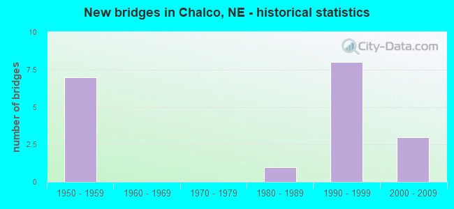
- New bridges - historical statistics
- 71950-1959
- 11980-1989
- 81990-1999
- 32000-2009
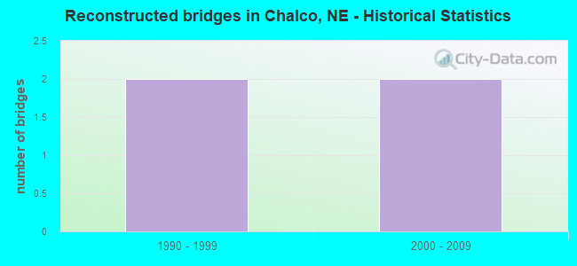
- Reconstructed bridges - Historical Statistics
- 21990-1999
- 22000-2009
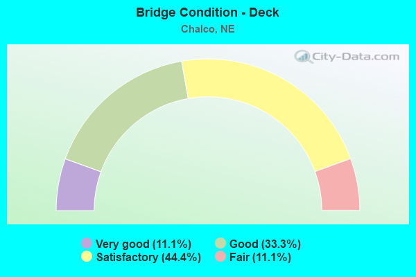
- Bridge Condition - Deck
- 11.1%Very good
- 33.3%Good
- 44.4%Satisfactory
- 11.1%Fair
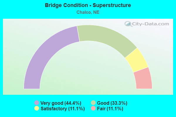
- Bridge Condition - Superstructure
- 44.4%Very good
- 33.3%Good
- 11.1%Satisfactory
- 11.1%Fair
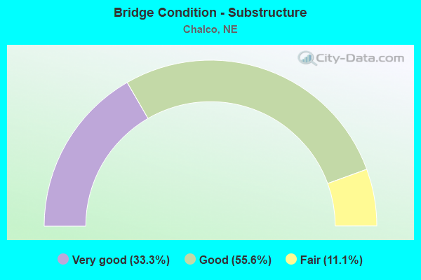
- Bridge Condition - Substructure
- 33.3%Very good
- 55.6%Good
- 11.1%Fair
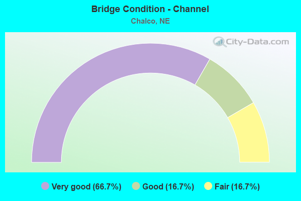
- Bridge Condition - Channel
- 66.7%Very good
- 16.7%Good
- 16.7%Fair
Find on map >> Show street view
Structure Number: C007710425, Location: 2N 4.5E GRETNA (Lat: 41.176700, Lng: -96.148300), Route carried "on" structure: County highway 3772, Year Built: 1980, Status: Open, Structure Length: 1.16m (3.81ft), Average Daily Traffic: 10,695 (year 2011), Average Future Daily Traffic: 12,090 (year 2033), Features Intersected: STREAM
Minimum Vertical Clearance: 30+ m (98+ ft), Kilometerpoint: 0.885, Lanes on structure: 2, Owner: County Highway Agency, Approaching Roadway Width: 9.1m (29.9ft), Skew: 3 degrees, Material/Design: Concrete, Design/Construction: Culvert, Number Of Spans In Main Unit: 2, Length of Maximum Span: 4.9m (16.1ft)
Condition: Channel: Fair, Culverts: Satisfactory, Operating Rating: 33.0 metric tons, Method Used To Determine Operating Rating: Field evaluation and documented engineering judgment, Inventory Rating: 22.0 metric tons, Method Used To Determine Inventory Rating: Field evaluation and documented engineering judgment, Structural Evaluation: Somewhat better than minimum adequacy, Waterway Adequacy: Equal to present desirable criteria, Approach Roadway Alignment: Equal to present desirable criteria, Designated Inspection Frequency: Every 24 months, Inspection Date: November 2021
Find on map >> Show street view
Structure Number: C007711925, Location: .5W OF CHALCO (Lat: 41.185800, Lng: -96.158300), Route carried "on" structure: County highway 3772, Year Built: 1995, Status: Open, Structure Length: 3.66m (12.01ft), Average Daily Traffic: 6,970 (year 2011), Average Future Daily Traffic: 10,804 (year 2033), Design Load: HS 20, Features Intersected: S BR PAPILLION CREEK
Minimum Vertical Clearance: 30+ m (98+ ft), Kilometerpoint: 0.694, Lanes on structure: 2, Owner: County Highway Agency, Approaching Roadway Width: 8.8m (28.9ft), Material/Design: Concrete continuous, Design/Construction: Slab, Number Of Spans In Main Unit: 3, Length of Maximum Span: 14.6m (47.9ft), Curb-To-Curb Width: 9.1m (29.9ft), Out-to-Out Width: 9.8m (32.2ft)
Condition: Deck: Good, Superstructure: Good, Substructure: Good, Channel: Very good, Operating Rating: 62.0 metric tons, Method Used To Determine Operating Rating: Load Factor (LF), Inventory Rating: 35.0 metric tons, Method Used To Determine Inventory Rating: Load Factor (LF), Structural Evaluation: Better than present minimum criteria, Deck Geometry: High priority of corrective action, Waterway Adequacy: Equal to present desirable criteria, Approach Roadway Alignment: Equal to present desirable criteria, Length Of Structure Improvement: 3.66m (12.01ft), Designated Inspection Frequency: Every 24 months, Inspection Date: August 2020, Deck Structure Type: Concrete Cast-file-Place, Wearing Surface/Protective System: Wearing Surface: Monolithic Concrete, Deck Protection: Epoxy Coated Reinforcing
Find on map >> Show street view
Structure Number: S050 08596, Location: JCT N50/N370 .7S (Lat: 41.137800, Lng: -96.139100), Route carried "on" structure: State highway 50, Year Built: 2005, Status: Open, Structure Length: 0.67m (2.20ft), Average Daily Traffic: 12,470 (year 2018), Truck Traffic: 13%, Average Future Daily Traffic: 20,576 (year 2038), Features Intersected: STREAM
Minimum Vertical Clearance: 30+ m (98+ ft), Kilometerpoint: 13.834, Lanes on structure: 2, Base Highway Network: Yes, Owner: State Highway Agency, Approaching Roadway Width: 13.4m (44.0ft), Skew: 2 degrees, Material/Design: Concrete, Design/Construction: Culvert, Number Of Spans In Main Unit: 2, Length of Maximum Span: 2.7m (8.9ft)
Condition: Channel: Very good, Culverts: Satisfactory, Operating Rating: 43.0 metric tons, Method Used To Determine Operating Rating: Field evaluation and documented engineering judgment, Inventory Rating: 33.0 metric tons, Method Used To Determine Inventory Rating: Field evaluation and documented engineering judgment, Structural Evaluation: Equal to present minimum criteria, Waterway Adequacy: Superior to present desirable criteria, Approach Roadway Alignment: Equal to present desirable criteria, Designated Inspection Frequency: Every 24 months, Inspection Date: January 2022
Find on map >> Show street view
Structure Number: S050 08662, Location: JCT N 370/50 (Lat: 41.147300, Lng: -96.138800), Route carried "on" structure: State highway 50, Year Built: 2000, Status: Open, Structure Length: 7.62m (25.00ft), Average Daily Traffic: 12,470 (year 2018), Truck Traffic: 13%, Average Future Daily Traffic: 20,576 (year 2038), Features Intersected: N370
Minimum Vertical Clearance: 30+ m (98+ ft), Kilometerpoint: 13.940, Lanes on structure: 4, Lanes under structure: 4, Base Highway Network: Yes, Owner: State Highway Agency, Approaching Roadway Width: 19.5m (64.0ft), Skew: 20 degrees, Material/Design: Prestressed concrete, Design/Construction: Stringer/Multi-beam, Number Of Spans In Main Unit: 2, Length of Maximum Span: 37.8m (124.0ft), Curb-To-Curb Width: 29.9m (98.1ft), Out-to-Out Width: 30.6m (100.4ft)
Condition: Deck: Good, Superstructure: Very good, Substructure: Good, Operating Rating: 90.0 metric tons, Method Used To Determine Operating Rating: Load Factor (LF), Inventory Rating: 41.0 metric tons, Method Used To Determine Inventory Rating: Load Factor (LF), Structural Evaluation: Better than present minimum criteria, Deck Geometry: Superior to present desirable criteria, Underclear: Somewhat better than minimum adequacy, Approach Roadway Alignment: Equal to present desirable criteria, Designated Inspection Frequency: Every 24 months, Inspection Date: January 2022, Deck Structure Type: Concrete Cast-file-Place, Wearing Surface/Protective System: Wearing Surface: Monolithic Concrete, Deck Protection: Epoxy Coated Reinforcing
Find on map >> Show street view
Structure Number: S050 08894, Location: 3SW MILLARD (Lat: 41.180500, Lng: -96.138900), Route carried "on" structure: State highway 50, Year Built: 1995, Status: Open, Structure Length: 15.97m (52.40ft), Average Daily Traffic: 35,690 (year 2018), Truck Traffic: 8%, Average Future Daily Traffic: 53,535 (year 2038), Design Load: HS 25 or greater, Features Intersected: BNSF/S PPLN CR 073-185-K
Minimum Vertical Clearance: 30+ m (98+ ft), Kilometerpoint: 14.313, Lanes on structure: 2, Base Highway Network: Yes, Owner: State Highway Agency, Approaching Roadway Width: 14.6m (47.9ft), Skew: 10 degrees, Material/Design: Prestressed concrete continuous, Design/Construction: Stringer/Multi-beam, Number Of Spans In Main Unit: 6, Length of Maximum Span: 33.5m (109.9ft), Curb or Sidewalk Widths: Left: 2.7m (8.9ft), Right: 0.0m, Curb-To-Curb Width: 20.4m (66.9ft), Out-to-Out Width: 24.2m (79.4ft)
Condition: Deck: Good, Superstructure: Very good, Substructure: Good, Channel: Very good, Operating Rating: 56.0 metric tons, Method Used To Determine Operating Rating: Load Factor (LF), Inventory Rating: 34.0 metric tons, Method Used To Determine Inventory Rating: Load Factor (LF), Structural Evaluation: Better than present minimum criteria, Deck Geometry: Superior to present desirable criteria, Underclear: Superior to present desirable criteria, Waterway Adequacy: Equal to present desirable criteria, Approach Roadway Alignment: Equal to present desirable criteria, Designated Inspection Frequency: Every 24 months, Inspection Date: January 2022, Deck Structure Type: Concrete Cast-file-Place, Wearing Surface/Protective System: Wearing Surface: Monolithic Concrete, Deck Protection: Epoxy Coated Reinforcing
Find on map >> Show street view
Structure Number: S080 43922, Location: N370 INTRCHG (Lat: 41.147000, Lng: -96.158400), Route carried "on" structure: Interstate 80, Year Built: 1992, Year Reconstructed: 2002, Status: Open, Structure Length: 7.96m (26.12ft), Average Daily Traffic: 53,360 (year 2018), Truck Traffic: 16%, Average Future Daily Traffic: 74,704 (year 2038), Design Load: HS 25 or greater, Features Intersected: N370
Minimum Vertical Clearance: 30+ m (98+ ft), Kilometerpoint: 70.685, Lanes on structure: 3, Lanes under structure: 4, Base Highway Network: Yes, Owner: State Highway Agency, Approaching Roadway Width: 29.9m (98.1ft), Skew: 3 degrees, Material/Design: Steel continuous, Design/Construction: Stringer/Multi-beam, Number Of Spans In Main Unit: 3, Length of Maximum Span: 52.4m (171.9ft), Curb-To-Curb Width: 37.8m (124.0ft), Out-to-Out Width: 38.4m (126.0ft)
Condition: Deck: Satisfactory, Superstructure: Very good, Substructure: Very good, Operating Rating: 61.0 metric tons, Method Used To Determine Operating Rating: Load Factor (LF), Inventory Rating: 36.0 metric tons, Method Used To Determine Inventory Rating: Load Factor (LF), Structural Evaluation: Equal to present desirable criteria, Deck Geometry: Superior to present desirable criteria, Underclear: Meets minimum limits, Approach Roadway Alignment: Equal to present desirable criteria, Designated Inspection Frequency: Every 24 months, Inspection Date: January 2022, Deck Structure Type: Concrete Cast-file-Place, Wearing Surface/Protective System: Wearing Surface: Monolithic Concrete, Deck Protection: Epoxy Coated Reinforcing
Find on map >> Show street view
Structure Number: S080 44066, Location: N50 INTRCHG (Lat: 41.161800, Lng: -96.138800), Route carried "on" structure: State highway 50, Year Built: 1958, Year Reconstructed: 2002, Status: Open, Structure Length: 7.89m (25.89ft), Average Daily Traffic: 26,190 (year 2018), Truck Traffic: 12%, Average Future Daily Traffic: 39,285 (year 2038), Design Load: HS 20, Features Intersected: I80
Minimum Vertical Clearance: 30+ m (98+ ft), Kilometerpoint: 14.101, Lanes on structure: 4, Lanes under structure: 4, Base Highway Network: Yes, Owner: State Highway Agency, Approaching Roadway Width: 20.7m (67.9ft), Skew: 24 degrees, Material/Design: Steel continuous, Design/Construction: Stringer/Multi-beam, Number Of Spans In Main Unit: 4, Length of Maximum Span: 23.2m (76.1ft), Curb-To-Curb Width: 26.2m (86.0ft), Out-to-Out Width: 27.0m (88.6ft)
Condition: Deck: Fair, Superstructure: Satisfactory, Substructure: Fair, Operating Rating: 62.0 metric tons, Method Used To Determine Operating Rating: Load Factor (LF), Inventory Rating: 37.0 metric tons, Method Used To Determine Inventory Rating: Load Factor (LF), Structural Evaluation: Somewhat better than minimum adequacy, Deck Geometry: Superior to present desirable criteria, Underclear: Equal to present minimum criteria, Approach Roadway Alignment: Equal to present desirable criteria, Designated Inspection Frequency: Every 24 months, Inspection Date: January 2022, Deck Structure Type: Concrete Cast-file-Place, Wearing Surface/Protective System: Wearing Surface: Integral Concrete, Deck Protection: Epoxy Coated Reinforcing
Find on map >> Show street view
Structure Number: S080 44207, Location: 2N N50 INTRCHG (Lat: 41.176200, Lng: -96.120800), Route carried "on" structure: Interstate 80, Year Built: 1959, Year Reconstructed: 2000, Status: Open, Structure Length: 21.58m (70.80ft), Average Daily Traffic: 77,980 (year 2018), Truck Traffic: 15%, Average Future Daily Traffic: 116,970 (year 2038), Design Load: HS 25 or greater, Features Intersected: BN/FAS 3789/CR 073-038-X
Minimum Vertical Clearance: 30+ m (98+ ft), Kilometerpoint: 71.144, Lanes on structure: 8, Lanes under structure: 4, Base Highway Network: Yes, Owner: State Highway Agency, Approaching Roadway Width: 37.8m (124.0ft), Skew: 22 degrees, Material/Design: Prestressed concrete continuous, Design/Construction: Stringer/Multi-beam, Number Of Spans In Main Unit: 5, Length of Maximum Span: 46.3m (151.9ft), Curb-To-Curb Width: 36.9m (121.1ft), Out-to-Out Width: 38.6m (126.6ft)
Condition: Deck: Satisfactory, Superstructure: Good, Substructure: Good, Channel: Good, Operating Rating: 58.0 metric tons, Method Used To Determine Operating Rating: Load Factor (LF), Inventory Rating: 34.0 metric tons, Method Used To Determine Inventory Rating: Load Factor (LF), Structural Evaluation: Better than present minimum criteria, Deck Geometry: Equal to present desirable criteria, Underclear: Somewhat better than minimum adequacy, Waterway Adequacy: Equal to present desirable criteria, Approach Roadway Alignment: Equal to present desirable criteria, Designated Inspection Frequency: Every 24 months, Inspection Date: January 2022, Deck Structure Type: Concrete Cast-file-Place, Wearing Surface/Protective System: Wearing Surface: Monolithic Concrete, Deck Protection: Epoxy Coated Reinforcing
Find on map >> Show street view
Structure Number: S080 44292, Location: JCT I80/126TH ST (Lat: 41.185100, Lng: -96.108900), Route carried "on" structure: County highway 5129, Year Built: 1990, Status: Open, Structure Length: 7.80m (25.59ft), Average Daily Traffic: 22,500 (year 2010), Average Future Daily Traffic: 22,500 (year 2033), Design Load: HS 20, Features Intersected: I80
Minimum Vertical Clearance: 30+ m (98+ ft), Kilometerpoint: 16.093, Lanes on structure: 4, Lanes under structure: 6, Base Highway Network: Yes, Owner: State Highway Agency, Approaching Roadway Width: 26.5m (86.9ft), Skew: 21 degrees, Material/Design: Steel continuous, Design/Construction: Stringer/Multi-beam, Number Of Spans In Main Unit: 2, Length of Maximum Span: 38.7m (127.0ft), Curb or Sidewalk Widths: Left: 0.0m, Right: 1.5m (4.9ft), Curb-To-Curb Width: 20.4m (66.9ft), Out-to-Out Width: 23.0m (75.5ft)
Condition: Deck: Very good, Superstructure: Good, Substructure: Very good, Operating Rating: 49.0 metric tons, Method Used To Determine Operating Rating: Load Factor (LF), Inventory Rating: 29.0 metric tons, Method Used To Determine Inventory Rating: Load Factor (LF), Structural Evaluation: Better than present minimum criteria, Deck Geometry: Superior to present desirable criteria, Underclear: Better than present minimum criteria, Approach Roadway Alignment: Equal to present desirable criteria, Designated Inspection Frequency: Every 24 months, Inspection Date: January 2022, Deck Structure Type: Concrete Cast-file-Place, Wearing Surface/Protective System: Wearing Surface: Bituminous, Membrane: Built-up, Deck Protection: Epoxy Coated Reinforcing
Find on map >> Show street view
Structure Number: S080 44324, Location: .2SW DOUGLAS/SARPY CL (Lat: 41.188300, Lng: -96.104300), Route carried "on" structure: County highway 5022, Year Built: 1990, Status: Open, Structure Length: 7.10m (23.29ft), Average Daily Traffic: 16,425 (year 2010), Average Future Daily Traffic: 16,425 (year 2033), Features Intersected: I80
Minimum Vertical Clearance: 30+ m (98+ ft), Kilometerpoint: 16.550, Lanes on structure: 4, Lanes under structure: 6, Base Highway Network: Yes, Owner: State Highway Agency, Approaching Roadway Width: 18.6m (61.0ft), Skew: 21 degrees, Material/Design: Steel continuous, Design/Construction: Stringer/Multi-beam, Number Of Spans In Main Unit: 2, Length of Maximum Span: 36.3m (119.1ft), Curb or Sidewalk Widths: Left: 1.5m (4.9ft), Right: 0.0m, Curb-To-Curb Width: 15.8m (51.8ft), Out-to-Out Width: 19.9m (65.3ft)
Condition: Deck: Satisfactory, Superstructure: Fair, Substructure: Very good, Operating Rating: 57.0 metric tons, Method Used To Determine Operating Rating: Load Factor (LF), Inventory Rating: 34.0 metric tons, Method Used To Determine Inventory Rating: Load Factor (LF), Structural Evaluation: Somewhat better than minimum adequacy, Deck Geometry: Meets minimum limits, Underclear: Better than present minimum criteria, Approach Roadway Alignment: Equal to present desirable criteria, Length Of Structure Improvement: 7.10m (23.29ft), Designated Inspection Frequency: Every 24 months, Inspection Date: January 2022, Deck Structure Type: Concrete Cast-file-Place, Wearing Surface/Protective System: Wearing Surface: Monolithic Concrete, Deck Protection: Epoxy Coated Reinforcing
Find on map >> Show street view
Structure Number: S080 44342, Location: US275/N92 INTRCHG 1S (Lat: 41.189900, Lng: -96.102000), Route carried "on" structure: Interstate 80, Year Built: 1959, Year Reconstructed: 2013, Status: Open, Structure Length: 14.39m (47.21ft), Average Daily Traffic: 103,755 (year 2018), Truck Traffic: 11%, Average Future Daily Traffic: 166,008 (year 2038), Features Intersected: FAU 5003/UP/CR 815-679-G
Minimum Vertical Clearance: 30+ m (98+ ft), Kilometerpoint: 71.361, Lanes on structure: 6, Lanes under structure: 2, Base Highway Network: Yes, Owner: State Highway Agency, Approaching Roadway Width: 48.6m (159.4ft), Skew: 30 degrees, Material/Design: Prestressed concrete, Design/Construction: Stringer/Multi-beam, Number Of Spans In Main Unit: 6, Length of Maximum Span: 39.6m (129.9ft), Curb-To-Curb Width: 48.6m (159.4ft), Out-to-Out Width: 48.6m (159.4ft)
Condition: Deck: Satisfactory, Superstructure: Very good, Substructure: Good, Channel: Very good, Operating Rating: 62.0 metric tons, Method Used To Determine Operating Rating: Load Factor (LF), Inventory Rating: 36.0 metric tons, Method Used To Determine Inventory Rating: Load Factor (LF), Structural Evaluation: Better than present minimum criteria, Deck Geometry: Superior to present desirable criteria, Underclear: Superior to present desirable criteria, Waterway Adequacy: Equal to present desirable criteria, Approach Roadway Alignment: Equal to present desirable criteria, Designated Inspection Frequency: Every 24 months, Inspection Date: January 2022, Deck Structure Type: Concrete Cast-file-Place, Wearing Surface/Protective System: Wearing Surface: Epoxy Overlay, Deck Protection: Epoxy Coated Reinforcing
Find on map >> Show street view
Structure Number: S050 08662, Location: JCT N 370/50 (Lat: 41.147300, Lng: -96.138800), Route carried "under" structure: State highway 370, Year Built: 2000, Structure Length: 0. m, Average Daily Traffic: 15,930 (year 2012), Truck Traffic: 4%, Features Intersected: N370, Facility Carried by Structure: N50
Minimum Vertical Clearance: 5.05m (16.57ft), Kilometerpoint: 0.838, Lanes on structure: 4, Lanes under structure: 4, Material/Design: Prestressed concrete, Design/Construction: Stringer/Multi-beam, Length of Maximum Span: 37.8m (124.0ft)
Find on map >> Show street view
Structure Number: S080 43922, Location: N370 INTRCHG (Lat: 41.147000, Lng: -96.158400), Route carried "under" structure: State highway 370, Year Built: 1992, Structure Length: 0. m, Average Daily Traffic: 12,210 (year 2012), Truck Traffic: 6%, Features Intersected: N370, Facility Carried by Structure: I80
Minimum Vertical Clearance: 4.97m (16.31ft), Kilometerpoint: 0.674, Lanes on structure: 4, Lanes under structure: 4, Material/Design: Steel continuous, Design/Construction: Stringer/Multi-beam, Length of Maximum Span: 52.4m (171.9ft)
Find on map >> Show street view
Structure Number: S080 44066, Location: N50 INTRCHG (Lat: 41.161800, Lng: -96.138800), Route carried "under" structure: Interstate 80, Year Built: 1958, Structure Length: 0. m, Average Daily Traffic: 63,185 (year 2013), Truck Traffic: 15%, Features Intersected: I80, Facility Carried by Structure: N50
Minimum Vertical Clearance: 5.38m (17.65ft), Kilometerpoint: 70.917, Lanes on structure: 4, Lanes under structure: 4, Material/Design: Steel continuous, Design/Construction: Stringer/Multi-beam, Length of Maximum Span: 23.2m (76.1ft)
Find on map >> Show street view
Structure Number: S080 44207, Location: 2N N50 INTRCHG (Lat: 41.176200, Lng: -96.120800), Route carried "under" structure: Interstate 80, Year Built: 1959, Structure Length: 0. m, Average Daily Traffic: 8,200 (year 2007), Features Intersected: BN/FAS 3789/CR 073-038-X
Minimum Vertical Clearance: 7.74m (25.39ft), Kilometerpoint: 71.144, Lanes on structure: 4, Lanes under structure: 4, Material/Design: Prestressed concrete continuous, Design/Construction: Stringer/Multi-beam, Length of Maximum Span: 46.3m (151.9ft)
Find on map >> Show street view
Structure Number: S080 44207, Location: 2N N50 INTRCHG (Lat: 41.176200, Lng: -96.120800), Route carried "under" structure: Interstate 80, Year Built: 1959, Structure Length: 0. m, Average Daily Traffic: 8,200 (year 2007), Features Intersected: BN/FAS 3789/CR 073-038-X
Minimum Vertical Clearance: 7.92m (25.98ft), Kilometerpoint: 71.144, Lanes on structure: 4, Lanes under structure: 4, Material/Design: Prestressed concrete continuous, Design/Construction: Stringer/Multi-beam, Length of Maximum Span: 46.3m (151.9ft)
Find on map >> Show street view
Structure Number: S080 44292, Location: JCT I80/126TH ST (Lat: 41.185100, Lng: -96.108900), Route carried "under" structure: Interstate 80, Year Built: 1990, Structure Length: 0. m, Average Daily Traffic: 82,755 (year 2013), Truck Traffic: 12%, Features Intersected: I80, Facility Carried by Structure: 126TH ST/FAU 5129
Minimum Vertical Clearance: 5.10m (16.73ft), Kilometerpoint: 71.281, Lanes on structure: 6, Lanes under structure: 6, Material/Design: Steel continuous, Design/Construction: Stringer/Multi-beam, Length of Maximum Span: 38.7m (127.0ft)
Find on map >> Show street view
Structure Number: S080 44324, Location: .2SW DOUGLAS/SARPY CL (Lat: 41.188300, Lng: -96.104300), Route carried "under" structure: Interstate 80, Year Built: 1990, Structure Length: 0. m, Average Daily Traffic: 82,755 (year 2013), Truck Traffic: 12%, Features Intersected: I80, Facility Carried by Structure: HARRISON/FAU 5022
Minimum Vertical Clearance: 5.05m (16.57ft), Kilometerpoint: 71.333, Lanes on structure: 6, Lanes under structure: 6, Material/Design: Steel continuous, Design/Construction: Stringer/Multi-beam, Length of Maximum Span: 36.3m (119.1ft)
Find on map >> Show street view
Structure Number: S080 44342, Location: US275/N92 INTRCHG 1S (Lat: 41.189900, Lng: -96.102000), Route carried "under" structure: City street 5003, Year Built: 1959, Structure Length: 0. m, Average Daily Traffic: 5,580 (year 2010), Features Intersected: FAU 5003/UP/CR 815-679-G, Facility Carried by Structure: I80
Minimum Vertical Clearance: 7.13m (23.39ft), Kilometerpoint: 16.130, Lanes on structure: 2, Lanes under structure: 2, Material/Design: Prestressed concrete, Design/Construction: Stringer/Multi-beam, Length of Maximum Span: 39.6m (129.9ft)