Bridge Statistics for Ceredo, West Virginia (WV)
Condition, Traffic, Stress, Structural Evaluation, Project Costs
- National Bridge Inventory (NBI) Statistics
- 22Number of bridges
- 509ft / 155mTotal length
- $2,155,000Total costs
- 141,148Total average daily traffic
- 23,496Total average daily truck traffic
- National Bridge Inventory (NBI) Registered Bridges for Ceredo
- No street view available for this location
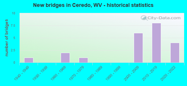
- New bridges - historical statistics
- 11940-1949
- 21960-1969
- 11970-1979
- 62000-2009
- 82010-2019
- 42020-2022


- Bridge Condition - Deck
- 30.0%Good
- 70.0%Satisfactory

- Bridge Condition - Superstructure
- 36.4%Good
- 36.4%Satisfactory
- 9.1%Fair
- 18.2%Poor

- Bridge Condition - Substructure
- 40.0%Good
- 60.0%Satisfactory

- Bridge Condition - Channel
- 83.3%Good
- 16.7%Satisfactory
Find on map >> Show street view
Structure Number: 50A012, Location: 0.05 MI WEST OF CR 7 (Lat: 38.340681, Lng: -82.522100), Route carried "on" structure: County highway 701, Year Built: 1945, Status: Open, Structure Length: 1.14m (3.74ft), Average Daily Traffic: 200 (year 2019), Truck Traffic: 5%, Average Future Daily Traffic: 254 (year 2039), Features Intersected: BUFFALO CREEK, Facility Carried by Structure: CR 7/1
Minimum Vertical Clearance: 30+ m (98+ ft), Kilometerpoint: 5.053, Lanes on structure: 1, Owner: State Highway Agency, Approaching Roadway Width: 5.5m (18.0ft), Material/Design: Concrete, Design/Construction: Arch - Deck, Number Of Spans In Main Unit: 1, Length of Maximum Span: 9.1m (29.9ft), Curb or Sidewalk Widths: Left: 0.1m (0.3ft), Right: 0.1m (0.3ft), Curb-To-Curb Width: 4.7m (15.4ft), Out-to-Out Width: 5.3m (17.4ft)
Condition: Superstructure: Poor, Channel: Satisfactory, Operating Rating: 53.5 metric tons, Method Used To Determine Operating Rating: Field evaluation and documented engineering judgment, Inventory Rating: 24.5 metric tons, Method Used To Determine Inventory Rating: Field evaluation and documented engineering judgment, Structural Evaluation: Meets minimum limits, Deck Geometry: High priority of replacement, Waterway Adequacy: Better than present minimum criteria, Approach Roadway Alignment: Somewhat better than minimum adequacy, Length Of Structure Improvement: 1.22m (4.00ft), Designated Inspection Frequency: Every 24 months, Other Special Inspection Frequency: Every 12 months, Inspection Date: April 2021, Other Special Inspection Date: April 2021, Bridge Improvement Cost: $110,000, Roadway Improvement Cost: $25,000, Total Project Cost: $155,000 ( Estimate for 2018), Deck Structure Type: Concrete Cast-file-Place, Wearing Surface/Protective System: Wearing Surface: Bituminous
Find on map >> Show street view
Structure Number: 50A136, Location: 0.10 MI EAST OF CR 3 (Lat: 38.391131, Lng: -82.556911), Route carried "on" structure: County highway 6004, Year Built: 1976, Status: Open, Structure Length: 9.37m (30.74ft), Average Daily Traffic: 2,031 (year 2019), Truck Traffic: 3%, Average Future Daily Traffic: 2,680 (year 2039), Design Load: HS 20, Features Intersected: TWELVEPOLE CREEK, Facility Carried by Structure: CR 60/4
Minimum Vertical Clearance: 30+ m (98+ ft), Kilometerpoint: 0.161, Lanes on structure: 2, Owner: State Highway Agency, Approaching Roadway Width: 7.3m (24.0ft), Material/Design: Steel continuous, Design/Construction: Stringer/Multi-beam, Number Of Spans In Main Unit: 1, Number Of Approach Spans: 2, Length of Maximum Span: 36.3m (119.1ft), Curb or Sidewalk Widths: Left: 0.0m, Right: 1.2m (3.9ft), Curb-To-Curb Width: 8.3m (27.2ft), Out-to-Out Width: 10.5m (34.4ft)
Condition: Deck: Satisfactory, Superstructure: Satisfactory, Substructure: Satisfactory, Channel: Good, Operating Rating: 67.1 metric tons, Method Used To Determine Operating Rating: Load Factor (LF), Inventory Rating: 39.9 metric tons, Method Used To Determine Inventory Rating: Load Factor (LF), Structural Evaluation: Equal to present minimum criteria, Deck Geometry: High priority of corrective action, Waterway Adequacy: Equal to present minimum criteria, Approach Roadway Alignment: Better than present minimum criteria, Designated Inspection Frequency: Every 24 months, Underwater Inspection Frequency: Every 60 months, Inspection Date: June 2021, Underwater Inspection Date: July 2019, Deck Structure Type: Concrete Cast-file-Place, Wearing Surface/Protective System: Wearing Surface: Monolithic Concrete, Deck Protection: Epoxy Coated Reinforcing
Find on map >> Show street view
Structure Number: 50A139, Location: 0.28 MI EAST OF US 52 EXI (Lat: 38.390869, Lng: -82.573700), Route carried "on" structure: Interstate 6400, Year Built: 1962, Status: Open, Structure Length: 6.23m (20.44ft), Average Daily Traffic: 11,458 (year 2019), Truck Traffic: 18%, Average Future Daily Traffic: 14,048 (year 2039), Design Load: HS 20+Mod, Features Intersected: US 52 AND WV 75, Facility Carried by Structure: I 64 EB
Minimum Vertical Clearance: 30+ m (98+ ft), Kilometerpoint: 2.012, Lanes on structure: 2, Lanes under structure: 4, Base Highway Network: Yes, Owner: State Highway Agency, Approaching Roadway Width: 13.7m (44.9ft), Skew: 11 degrees, Material/Design: Concrete continuous, Design/Construction: Tee Beam, Number Of Spans In Main Unit: 2, Number Of Approach Spans: 2, Length of Maximum Span: 17.7m (58.1ft), Curb-To-Curb Width: 9.1m (29.9ft), Out-to-Out Width: 10.7m (35.1ft)
Condition: Deck: Satisfactory, Superstructure: Poor, Substructure: Satisfactory, Operating Rating: 77.1 metric tons, Method Used To Determine Operating Rating: Load Factor (LF), Inventory Rating: 46.3 metric tons, Method Used To Determine Inventory Rating: Load Factor (LF), Structural Evaluation: Meets minimum limits, Deck Geometry: Meets minimum limits, Underclear: Meets minimum limits, Approach Roadway Alignment: Equal to present desirable criteria, Length Of Structure Improvement: 7.28m (23.88ft), Designated Inspection Frequency: Every 24 months, Inspection Date: May 2021, Bridge Improvement Cost: $1,005,000, Roadway Improvement Cost: $955,000, Total Project Cost: $2,000,000 ( Estimate for 2017), Deck Structure Type: Concrete Cast-file-Place, Wearing Surface/Protective System: Wearing Surface: Latex Concrete
Find on map >> Show street view
Structure Number: 50A192, Location: 0.65 MILE WEST OF CR 60/5 (Lat: 38.396339, Lng: -82.541500), Route carried "on" structure: US 6000, Year Built: 2000, Status: Open, Structure Length: 9.26m (30.38ft), Average Daily Traffic: 9,500 (year 2019), Truck Traffic: 5%, Average Future Daily Traffic: 12,350 (year 2039), Design Load: HS 25 or greater, Features Intersected: TWELVEPOLE CREEK, Facility Carried by Structure: US 60
Minimum Vertical Clearance: 30+ m (98+ ft), Kilometerpoint: 5.053, Lanes on structure: 2, Base Highway Network: Yes, Owner: State Highway Agency, Approaching Roadway Width: 12.2m (40.0ft), Skew: 2 degrees, Material/Design: Concrete continuous, Design/Construction: Stringer/Multi-beam, Number Of Spans In Main Unit: 1, Number Of Approach Spans: 2, Length of Maximum Span: 38.5m (126.3ft), Curb or Sidewalk Widths: Left: 1.5m (4.9ft), Right: 0.0m, Curb-To-Curb Width: 12.0m (39.4ft), Out-to-Out Width: 14.8m (48.6ft)
Condition: Deck: Satisfactory, Superstructure: Satisfactory, Substructure: Satisfactory, Channel: Good, Operating Rating: 87.1 metric tons, Method Used To Determine Operating Rating: Load Factor (LF), Inventory Rating: 51.7 metric tons, Method Used To Determine Inventory Rating: Load Factor (LF), Structural Evaluation: Equal to present minimum criteria, Deck Geometry: Somewhat better than minimum adequacy, Waterway Adequacy: Equal to present desirable criteria, Approach Roadway Alignment: Better than present minimum criteria, Designated Inspection Frequency: Every 24 months, Underwater Inspection Frequency: Every 60 months, Other Special Inspection Frequency: Every 12 months, Inspection Date: May 2020, Underwater Inspection Date: August 2018, Other Special Inspection Date: March 2021, Deck Structure Type: Concrete Cast-file-Place, Wearing Surface/Protective System: Wearing Surface: Integral Concrete, Membrane: Epoxy, Deck Protection: Epoxy Coated Reinforcing
Find on map >> Show street view
Structure Number: 50A196, Location: 0.01 MILE NORTH OF CR 3 (Lat: 38.371861, Lng: -82.545500), Route carried "on" structure: County highway 318, Year Built: 2001, Status: Open, Structure Length: 20.82m (68.31ft), Average Daily Traffic: 2,300 (year 2018), Truck Traffic: 5%, Average Future Daily Traffic: 3,542 (year 2038), Design Load: HL 93, Features Intersected: TWELVEPOLE CREEK, Facility Carried by Structure: CR 3/18
Minimum Vertical Clearance: 30+ m (98+ ft), Kilometerpoint: 0.016, Lanes on structure: 2, Owner: State Highway Agency, Approaching Roadway Width: 10.7m (35.1ft), Skew: 11 degrees, Material/Design: Prestressed concrete, Design/Construction: Box Beam or Girders - Single/Spread, Number Of Spans In Main Unit: 1, Number Of Approach Spans: 4, Length of Maximum Span: 42.4m (139.1ft), Curb-To-Curb Width: 10.4m (34.1ft), Out-to-Out Width: 11.1m (36.4ft)
Condition: Deck: Satisfactory, Superstructure: Fair, Substructure: Satisfactory, Channel: Good, Operating Rating: 39.9 metric tons, Method Used To Determine Operating Rating: Load and Resistance Factor (LRFR), Inventory Rating: 30.8 metric tons, Method Used To Determine Inventory Rating: Load and Resistance Factor (LRFR), Structural Evaluation: Somewhat better than minimum adequacy, Deck Geometry: Somewhat better than minimum adequacy, Waterway Adequacy: Better than present minimum criteria, Approach Roadway Alignment: Better than present minimum criteria, Designated Inspection Frequency: Every 24 months, Inspection Date: May 2020, Deck Structure Type: Concrete Cast-file-Place, Wearing Surface/Protective System: Wearing Surface: Integral Concrete, Membrane: Preformed Fabric, Deck Protection: Epoxy Coated Reinforcing
Find on map >> Show street view
Structure Number: 50A208, Location: 1.21 MI. E. OF WV 75 EXIT (Lat: 38.391861, Lng: -82.547719), Route carried "on" structure: Interstate 6400, Year Built: 2005, Status: Open, Structure Length: 12.32m (40.42ft), Average Daily Traffic: 13,297 (year 2018), Truck Traffic: 18%, Average Future Daily Traffic: 28,589 (year 2038), Design Load: HL 93, Features Intersected: County Route 5/1, Facility Carried by Structure: INTERSTATE 64 EBL
Minimum Vertical Clearance: 30+ m (98+ ft), Kilometerpoint: 4.297, Lanes on structure: 2, Lanes under structure: 1, Base Highway Network: Yes, Owner: State Highway Agency, Approaching Roadway Width: 12.8m (42.0ft), Skew: 12 degrees, Material/Design: Steel continuous, Design/Construction: Stringer/Multi-beam, Number Of Spans In Main Unit: 1, Number Of Approach Spans: 2, Length of Maximum Span: 48.0m (157.5ft), Curb-To-Curb Width: 12.8m (42.0ft), Out-to-Out Width: 13.6m (44.6ft)
Condition: Deck: Satisfactory, Superstructure: Good, Substructure: Satisfactory, Operating Rating: 55.3 metric tons, Method Used To Determine Operating Rating: Load and Resistance Factor (LRFR), Inventory Rating: 43.5 metric tons, Method Used To Determine Inventory Rating: Load and Resistance Factor (LRFR), Structural Evaluation: Equal to present minimum criteria, Deck Geometry: Equal to present desirable criteria, Underclear: Superior to present desirable criteria, Approach Roadway Alignment: Equal to present desirable criteria, Designated Inspection Frequency: Every 24 months, Other Special Inspection Frequency: Every 12 months, Inspection Date: March 2020, Other Special Inspection Date: March 2021, Deck Structure Type: Concrete Cast-file-Place, Wearing Surface/Protective System: Wearing Surface: Monolithic Concrete, Deck Protection: Epoxy Coated Reinforcing
Find on map >> Show street view
Structure Number: 50A209, Location: 1.21 MI. E. OF WV 75 EXIT (Lat: 38.392061, Lng: -82.547850), Route carried "on" structure: Interstate 6400, Year Built: 2005, Status: Open, Structure Length: 12.32m (40.42ft), Average Daily Traffic: 13,297 (year 2018), Truck Traffic: 18%, Average Future Daily Traffic: 28,589 (year 2038), Design Load: HL 93, Features Intersected: County Route 5/1, Facility Carried by Structure: INTERSTATE 64 WBL
Minimum Vertical Clearance: 30+ m (98+ ft), Kilometerpoint: 4.297, Lanes on structure: 2, Lanes under structure: 1, Base Highway Network: Yes, Owner: State Highway Agency, Approaching Roadway Width: 12.8m (42.0ft), Skew: 12 degrees, Material/Design: Steel continuous, Design/Construction: Stringer/Multi-beam, Number Of Spans In Main Unit: 1, Number Of Approach Spans: 2, Length of Maximum Span: 48.0m (157.5ft), Curb-To-Curb Width: 12.8m (42.0ft), Out-to-Out Width: 13.6m (44.6ft)
Condition: Deck: Satisfactory, Superstructure: Good, Substructure: Satisfactory, Operating Rating: 42.6 metric tons, Method Used To Determine Operating Rating: Load and Resistance Factor (LRFR), Inventory Rating: 32.7 metric tons, Method Used To Determine Inventory Rating: Load and Resistance Factor (LRFR), Structural Evaluation: Equal to present minimum criteria, Deck Geometry: Equal to present desirable criteria, Underclear: Superior to present desirable criteria, Approach Roadway Alignment: Equal to present desirable criteria, Designated Inspection Frequency: Every 24 months, Other Special Inspection Frequency: Every 12 months, Inspection Date: March 2020, Other Special Inspection Date: March 2021, Deck Structure Type: Concrete Cast-file-Place, Wearing Surface/Protective System: Wearing Surface: Monolithic Concrete, Deck Protection: Epoxy Coated Reinforcing
Find on map >> Show street view
Structure Number: 50A226, Location: 0.78 mile east of WV75 (Lat: 38.390511, Lng: -82.558631), Route carried "on" structure: Interstate 6400, Year Built: 2011, Status: Open, Structure Length: 37.03m (121.49ft), Average Daily Traffic: 21,800 (year 2020), Truck Traffic: 23%, Average Future Daily Traffic: 31,174 (year 2040), Design Load: HL 93, Features Intersected: CR 3&5, 12 POLE, NSRR, Facility Carried by Structure: I64 EBL
Minimum Vertical Clearance: 30+ m (98+ ft), Kilometerpoint: 3.267, Lanes on structure: 2, Lanes under structure: 4, Base Highway Network: Yes, Owner: State Highway Agency, Approaching Roadway Width: 12.2m (40.0ft), Skew: 10 degrees, Material/Design: Prestressed concrete continuous, Design/Construction: Stringer/Multi-beam, Number Of Spans In Main Unit: 8, Number Of Approach Spans: 1, Length of Maximum Span: 46.0m (150.9ft), Curb-To-Curb Width: 9.8m (32.2ft), Out-to-Out Width: 10.5m (34.4ft)
Condition: Deck: Good, Superstructure: Satisfactory, Substructure: Good, Channel: Good, Operating Rating: 32.7 metric tons, Method Used To Determine Operating Rating: Load and Resistance Factor (LRFR), Inventory Rating: 22.7 metric tons, Method Used To Determine Inventory Rating: Load and Resistance Factor (LRFR), Structural Evaluation: Somewhat better than minimum adequacy, Deck Geometry: Meets minimum limits, Underclear: Equal to present desirable criteria, Waterway Adequacy: Better than present minimum criteria, Approach Roadway Alignment: Equal to present minimum criteria, Designated Inspection Frequency: Every 24 months, Inspection Date: September 2021, Deck Structure Type: Concrete Cast-file-Place, Wearing Surface/Protective System: Wearing Surface: Monolithic Concrete, Deck Protection: Epoxy Coated Reinforcing
Find on map >> Show street view
Structure Number: 50A227, Location: 0.78 mile west of WV75 (Lat: 38.390619, Lng: -82.558650), Route carried "on" structure: Interstate 6400, Year Built: 2010, Status: Open, Structure Length: 37.03m (121.49ft), Average Daily Traffic: 21,800 (year 2020), Truck Traffic: 23%, Average Future Daily Traffic: 31,174 (year 2040), Design Load: HL 93, Features Intersected: CR 3&5, 12 POLE, NSRR, Facility Carried by Structure: I64 WBL
Minimum Vertical Clearance: 30+ m (98+ ft), Kilometerpoint: 3.267, Lanes on structure: 2, Lanes under structure: 4, Base Highway Network: Yes, Owner: State Highway Agency, Approaching Roadway Width: 12.2m (40.0ft), Skew: 10 degrees, Material/Design: Prestressed concrete continuous, Design/Construction: Stringer/Multi-beam, Number Of Spans In Main Unit: 1, Number Of Approach Spans: 8, Length of Maximum Span: 46.0m (150.9ft), Curb-To-Curb Width: 9.8m (32.2ft), Out-to-Out Width: 10.5m (34.4ft)
Condition: Deck: Satisfactory, Superstructure: Satisfactory, Substructure: Good, Channel: Good, Operating Rating: 30.8 metric tons, Method Used To Determine Operating Rating: Load and Resistance Factor (LRFR), Inventory Rating: 22.7 metric tons, Method Used To Determine Inventory Rating: Load and Resistance Factor (LRFR), Structural Evaluation: Somewhat better than minimum adequacy, Deck Geometry: Meets minimum limits, Underclear: Equal to present desirable criteria, Waterway Adequacy: Equal to present desirable criteria, Approach Roadway Alignment: Equal to present desirable criteria, Designated Inspection Frequency: Every 24 months, Inspection Date: August 2021, Deck Structure Type: Concrete Cast-file-Place, Wearing Surface/Protective System: Wearing Surface: Monolithic Concrete, Deck Protection: Epoxy Coated Reinforcing
Find on map >> Show street view
Structure Number: 50A246, Location: 0.29 mile East of US 52 (Lat: 38.390219, Lng: -82.564900), Route carried "on" structure: Interstate 6400, Year Built: 2021, Status: Open, Structure Length: 5.17m (16.96ft), Average Daily Traffic: 11,818 (year 2019), Truck Traffic: 18%, Average Future Daily Traffic: 28,589 (year 2039), Design Load: HL 93, Features Intersected: County Route 2, Facility Carried by Structure: I 64 East Bound
Minimum Vertical Clearance: 30+ m (98+ ft), Kilometerpoint: 2.816, Lanes on structure: 2, Lanes under structure: 2, Base Highway Network: Yes, Owner: State Highway Agency, Approaching Roadway Width: 11.6m (38.1ft), Skew: 3 degrees, Material/Design: Steel continuous, Design/Construction: Stringer/Multi-beam, Number Of Spans In Main Unit: 2, Number Of Approach Spans: 1, Length of Maximum Span: 23.4m (76.8ft), Curb-To-Curb Width: 11.9m (39.0ft), Out-to-Out Width: 12.9m (42.3ft)
Condition: Deck: Good, Superstructure: Good, Substructure: Good, Operating Rating: 43.5 metric tons, Method Used To Determine Operating Rating: Load and Resistance Factor (LRFR), Inventory Rating: 33.6 metric tons, Method Used To Determine Inventory Rating: Load and Resistance Factor (LRFR), Structural Evaluation: Better than present minimum criteria, Deck Geometry: Equal to present minimum criteria, Underclear: Equal to present minimum criteria, Approach Roadway Alignment: Equal to present desirable criteria, Designated Inspection Frequency: Every 24 months, Inspection Date: January 2021, Deck Structure Type: Concrete Cast-file-Place, Wearing Surface/Protective System: Deck Protection: Epoxy Coated Reinforcing
Find on map >> Show street view
Structure Number: 50A247, Location: 0.29 MI EAST OF US 52 (Lat: 38.390411, Lng: -82.564769), Route carried "on" structure: Interstate 64, Year Built: 2021, Status: Not yet open, Structure Length: 3.92m (12.86ft), Average Daily Traffic: 13,297 (year 2019), Truck Traffic: 12%, Average Future Daily Traffic: 19,014 (year 2039), Design Load: HL 93, Features Intersected: COUNTY ROUTE 2
Minimum Vertical Clearance: 30+ m (98+ ft), Kilometerpoint: 2.816, Lanes on structure: 2, Lanes under structure: 2, Base Highway Network: Yes, Owner: State Highway Agency, Approaching Roadway Width: 13.7m (44.9ft), Skew: 3 degrees, Material/Design: Steel continuous, Design/Construction: Stringer/Multi-beam, Number Of Spans In Main Unit: 1, Number Of Approach Spans: 2, Length of Maximum Span: 17.5m (57.4ft), Curb-To-Curb Width: 11.9m (39.0ft), Out-to-Out Width: 12.9m (42.3ft)
Condition: Deck: Good, Superstructure: Good, Substructure: Good, Operating Rating: 84.4 metric tons, Method Used To Determine Operating Rating: Load and Resistance Factor (LRFR), Inventory Rating: 65.3 metric tons, Method Used To Determine Inventory Rating: Load and Resistance Factor (LRFR), Structural Evaluation: Better than present minimum criteria, Deck Geometry: Equal to present minimum criteria, Underclear: Better than present minimum criteria, Approach Roadway Alignment: Equal to present minimum criteria, Designated Inspection Frequency: Every 24 months, Inspection Date: June 2021, Deck Structure Type: Concrete Cast-file-Place, Wearing Surface/Protective System: Membrane: Epoxy, Deck Protection: Epoxy Coated Reinforcing
Find on map >> Show street view
Structure Number: 50A139, Location: 0.28 MI EAST OF US 52 EXI (Lat: 38.390869, Lng: -82.573700), Route carried "under" structure: US 7500, Year Built: 1962, Structure Length: 0. m, Average Daily Traffic: 8,700 (year 0007), Truck Traffic: 18%, Features Intersected: US 52 AND WV 75, Facility Carried by Structure: I 64 EB
Minimum Vertical Clearance: 5.00m (16.40ft), Kilometerpoint: 7.612, Lanes on structure: 2, Lanes under structure: 4, Length of Maximum Span: 17.7m (58.1ft)
Find on map >> Show street view
Structure Number: 50A208, Location: 1.21 MI. E. OF WV 75 EXIT (Lat: 38.391861, Lng: -82.547719), Route carried "under" structure: County highway 501, Year Built: 2005, Structure Length: 0. m, Average Daily Traffic: 50 (year 0007), Features Intersected: County Route 5/1, Facility Carried by Structure: INTERSTATE 64 EBL
Minimum Vertical Clearance: 24.38m (79.99ft), Kilometerpoint: 3.251, Lanes on structure: 2, Lanes under structure: 1, Length of Maximum Span: 48.0m (157.5ft)
Find on map >> Show street view
Structure Number: 50A209, Location: 1.21 MI. E. OF WV 75 EXIT (Lat: 38.392061, Lng: -82.547850), Route carried "under" structure: County highway 501, Year Built: 2005, Structure Length: 0. m, Average Daily Traffic: 350 (year 0007), Truck Traffic: 11%, Features Intersected: County Route 5/1, Facility Carried by Structure: INTERSTATE 64 WBL
Minimum Vertical Clearance: 24.38m (79.99ft), Kilometerpoint: 3.251, Lanes on structure: 2, Lanes under structure: 1, Length of Maximum Span: 48.0m (157.5ft)
Find on map >> Show street view
Structure Number: 50A226, Location: 0.78 mile east of WV75 (Lat: 38.390542, Lng: -82.559100), Route carried "under" structure: County highway 300, Year Built: 2011, Structure Length: 0. m, Average Daily Traffic: 2,300 (year 2013), Truck Traffic: 5%, Features Intersected: CR 3&5, 12 POLE, NSRR, Facility Carried by Structure: I64 EBL
Minimum Vertical Clearance: 12.14m (39.83ft), Kilometerpoint: 6.067, Lanes on structure: 2, Lanes under structure: 3, Length of Maximum Span: 46.0m (150.9ft)
Find on map >> Show street view
Structure Number: 50A226, Location: 0.78 mile east of WV75 (Lat: 38.390536, Lng: -82.559414), Route carried "under" structure: County highway 202, Year Built: 2011, Structure Length: 0. m, Average Daily Traffic: 50 (year 2013), Truck Traffic: 5%, Features Intersected: CR 3&5, 12 POLE, NSRR, Facility Carried by Structure: I64 EBL
Minimum Vertical Clearance: 10.26m (33.66ft), Kilometerpoint: 4.683, Lanes on structure: 2, Lanes under structure: 3, Length of Maximum Span: 46.0m (150.9ft)
Find on map >> Show street view
Structure Number: 50A226, Location: 0.78 mile east of WV75 (Lat: 38.390692, Lng: -82.556222), Route carried "under" structure: County highway 500, Year Built: 2011, Structure Length: 0. m, Average Daily Traffic: 2,900 (year 0010), Truck Traffic: 5%, Features Intersected: CR 3&5, 12 POLE, NSRR, Facility Carried by Structure: I64 EBL
Minimum Vertical Clearance: 8.41m (27.59ft), Kilometerpoint: 4.683, Lanes on structure: 2, Lanes under structure: 3, Length of Maximum Span: 46.0m (150.9ft)
Find on map >> Show street view
Structure Number: 50A227, Location: 0.78 mile west of WV75 (Lat: 38.390714, Lng: -82.559497), Route carried "under" structure: County highway 202, Year Built: 2010, Structure Length: 0. m, Average Daily Traffic: 50 (year 2010), Truck Traffic: 5%, Features Intersected: CR 3&5, 12 POLE, NSRR, Facility Carried by Structure: I64 WBL
Minimum Vertical Clearance: 10.26m (33.66ft), Kilometerpoint: 4.683, Lanes on structure: 2, Lanes under structure: 3, Length of Maximum Span: 46.0m (150.9ft)
Find on map >> Show street view
Structure Number: 50A227, Location: 0.78 mile west of WV75 (Lat: 38.390769, Lng: -82.559078), Route carried "under" structure: County highway 300, Year Built: 2010, Structure Length: 0. m, Average Daily Traffic: 2,300 (year 2010), Truck Traffic: 5%, Features Intersected: CR 3&5, 12 POLE, NSRR, Facility Carried by Structure: I64 WBL
Minimum Vertical Clearance: 12.14m (39.83ft), Kilometerpoint: 6.067, Lanes on structure: 2, Lanes under structure: 3, Length of Maximum Span: 46.0m (150.9ft)
Find on map >> Show street view
Structure Number: 50A227, Location: 0.78 mile west of WV75 (Lat: 38.390878, Lng: -82.556158), Route carried "under" structure: County highway 500, Year Built: 2010, Structure Length: 0. m, Average Daily Traffic: 2,900 (year 0010), Truck Traffic: 5%, Features Intersected: CR 3&5, 12 POLE, NSRR, Facility Carried by Structure: I64 WBL
Minimum Vertical Clearance: 8.41m (27.59ft), Kilometerpoint: 4.683, Lanes on structure: 2, Lanes under structure: 3, Length of Maximum Span: 46.0m (150.9ft)
Find on map >> Show street view
Structure Number: 50A246, Location: 0.29 mile East of US 52 (Lat: 38.390219, Lng: -82.564900), Route carried "under" structure: County highway 200, Year Built: 2021, Structure Length: 0. m, Average Daily Traffic: 400 (year 2019), Truck Traffic: 18%, Features Intersected: County Route 2, Facility Carried by Structure: I 64 East Bound
Minimum Vertical Clearance: 5.08m (16.67ft), Kilometerpoint: 3.798, Lanes on structure: 2, Lanes under structure: 2, Length of Maximum Span: 23.4m (76.8ft)
Find on map >> Show street view
Structure Number: 50A247, Location: 0.29 MI EAST OF US 52 (Lat: 38.390411, Lng: -82.564769), Route carried "under" structure: County highway 200, Year Built: 2021, Structure Length: 0. m, Average Daily Traffic: 350 (year 0008), Truck Traffic: 11%, Features Intersected: COUNTY ROUTE 2, Facility Carried by Structure: I64 WB
Minimum Vertical Clearance: 4.98m (16.34ft), Kilometerpoint: 3.798, Lanes on structure: 2, Lanes under structure: 2, Length of Maximum Span: 17.5m (57.4ft)