Bridge Statistics for Centreville, Michigan (MI)
Condition, Traffic, Stress, Structural Evaluation, Project Costs
- National Bridge Inventory (NBI) Statistics
- 13Number of bridges
- 121ft / 37.5mTotal length
- $1,484,000Total costs
- 18,899Total average daily traffic
- 1,014Total average daily truck traffic
- 29,606Total future (year 2017) average daily traffic
- National Bridge Inventory (NBI) Registered Bridges for Centreville
- No street view available for this location
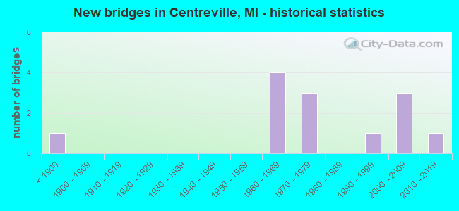
- New bridges - historical statistics
- 1Before 1900
- 41960-1969
- 31970-1979
- 11990-1999
- 32000-2009
- 12010-2019
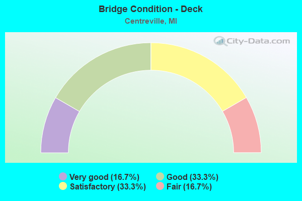
- Bridge Condition - Deck
- 16.7%Very good
- 33.3%Good
- 33.3%Satisfactory
- 16.7%Fair
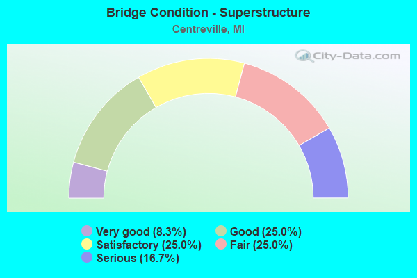
- Bridge Condition - Superstructure
- 8.3%Very good
- 25.0%Good
- 25.0%Satisfactory
- 25.0%Fair
- 16.7%Serious
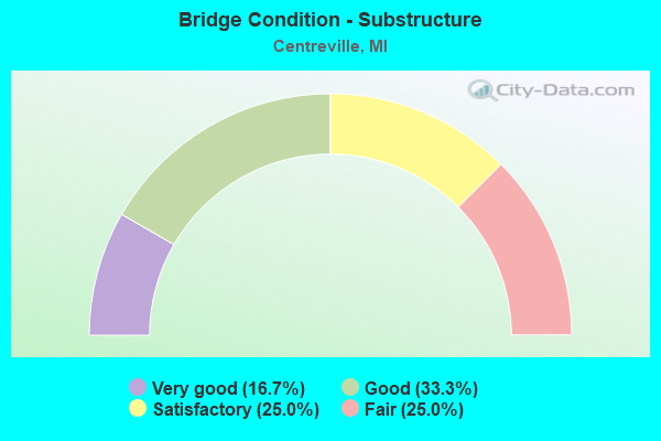
- Bridge Condition - Substructure
- 16.7%Very good
- 33.3%Good
- 25.0%Satisfactory
- 25.0%Fair
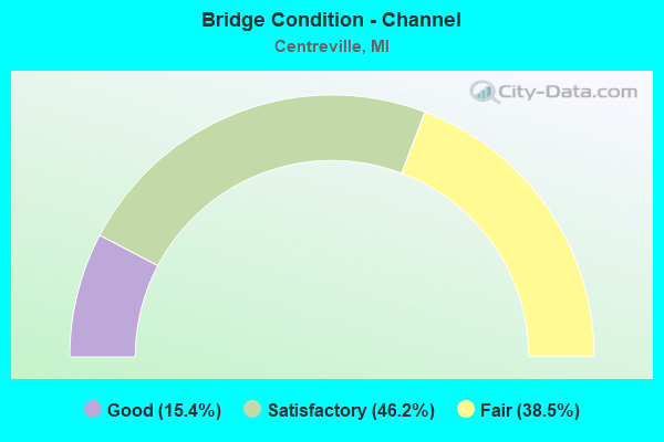
- Bridge Condition - Channel
- 15.4%Good
- 46.2%Satisfactory
- 38.5%Fair
Find on map >> Show street view
Structure Number: 10282, Location: 5.4 MI SE OF M-60 (Lat: 41.922867, Lng: -85.547364), Route carried "on" structure: State highway 86, Year Built: 1999, Status: Open, Structure Length: 2.71m (8.89ft), Average Daily Traffic: 4,570 (year 2007), Truck Traffic: 5%, Average Future Daily Traffic: 10,427 (year 2018), Design Load: HS 25 or greater, Features Intersected: PRAIRIE RIVER
Minimum Vertical Clearance: 30.48m (100.00ft), Kilometerpoint: 6.581, Lanes on structure: 2, Base Highway Network: Yes (Inventory Route: 23, Subroute: 10), Owner: State Highway Agency, Approaching Roadway Width: 14.3m (46.9ft), Material/Design: Prestressed concrete, Design/Construction: Box Beam or Girders - Multiple, Number Of Spans In Main Unit: 1, Length of Maximum Span: 27.1m (88.9ft), Curb-To-Curb Width: 14.3m (46.9ft), Out-to-Out Width: 15.6m (51.2ft)
Condition: Deck: Good, Superstructure: Satisfactory, Substructure: Good, Channel: Fair, Operating Rating: 97.2 metric tons, Method Used To Determine Operating Rating: Load Factor (LF) rating reported by rating factor (RF) method using MS18 loading, Inventory Rating: 52.5 metric tons, Method Used To Determine Inventory Rating: Load Factor (LF) rating reported by rating factor (RF) method using MS18 loading, Structural Evaluation: Equal to present minimum criteria, Deck Geometry: Superior to present desirable criteria, Waterway Adequacy: Equal to present desirable criteria, Approach Roadway Alignment: Equal to present minimum criteria, Designated Inspection Frequency: Every 24 months, Inspection Date: September 2021, Deck Structure Type: Concrete Cast-file-Place, Wearing Surface/Protective System: Wearing Surface: Monolithic Concrete, Deck Protection: Epoxy Coated Reinforcing
Find on map >> Show street view
Structure Number: 10283, Location: 3.8 MI W OF M-66 (Lat: 41.919025, Lng: -85.481478), Route carried "on" structure: State highway 86, Year Built: 2016, Status: Open, Structure Length: 3.17m (10.40ft), Average Daily Traffic: 4,825 (year 2015), Truck Traffic: 8%, Average Future Daily Traffic: 5,549 (year 2035), Design Load: Greater than HL93, Features Intersected: PRAIRIE RIVER
Minimum Vertical Clearance: 30.48m (100.00ft), Kilometerpoint: 17.375, Lanes on structure: 2, Base Highway Network: Yes (Inventory Route: 375, Subroute: 7), Owner: State Highway Agency, Approaching Roadway Width: 12.2m (40.0ft), Material/Design: Prestressed concrete, Design/Construction: Stringer/Multi-beam, Number Of Spans In Main Unit: 1, Length of Maximum Span: 30.8m (101.0ft), Curb-To-Curb Width: 12.2m (40.0ft), Out-to-Out Width: 12.9m (42.3ft)
Condition: Deck: Very good, Superstructure: Satisfactory, Substructure: Very good, Channel: Good, Operating Rating: 81.0 metric tons, Method Used To Determine Operating Rating: Load and Resistance Factor Rating (LRFR) rating reported by rating factor(RF) method using HL-93 loadings, Inventory Rating: 52.8 metric tons, Method Used To Determine Inventory Rating: Load and Resistance Factor Rating (LRFR) rating reported by rating factor(RF) method using HL-93 loadings, Structural Evaluation: Equal to present minimum criteria, Deck Geometry: Equal to present minimum criteria, Waterway Adequacy: Equal to present desirable criteria, Approach Roadway Alignment: Equal to present desirable criteria, Length Of Structure Improvement: 2.74m (8.99ft), Designated Inspection Frequency: Every 24 months, Inspection Date: September 2021, Bridge Improvement Cost: $425,000, Deck Structure Type: Concrete Cast-file-Place, Wearing Surface/Protective System: Wearing Surface: Monolithic Concrete, Deck Protection: Bituminous
Find on map >> Show street view
Structure Number: 10294, Location: 0.1 MI N OF CENTREVILLE (Lat: 41.931067, Lng: -85.526797), Route carried "on" structure: County highway , Year Built: 1967, Status: Posted for load, Structure Length: 2.01m (6.59ft), Average Daily Traffic: 1,333 (year 2003), Truck Traffic: 5%, Average Future Daily Traffic: 1,956 (year 2023), Design Load: HS 20, Features Intersected: PRAIRIE RIVER, Facility Carried by Structure: DEAN STREET
Minimum Vertical Clearance: 30.48m (100.00ft), Kilometerpoint: 1.542, Lanes on structure: 2, Owner: County Highway Agency, Approaching Roadway Width: 9.1m (29.9ft), Material/Design: Wood or Timber, Design/Construction: Slab, Number Of Spans In Main Unit: 3, Length of Maximum Span: 6.7m (22.0ft), Curb-To-Curb Width: 9.1m (29.9ft), Out-to-Out Width: 9.7m (31.8ft)
Condition: Deck: Fair, Superstructure: Fair, Substructure: Fair, Channel: Fair, Operating Rating: 48.0 metric tons, Method Used To Determine Operating Rating: Allowable Stress (AS) rating reported by rating factor (RF) method using MS18 loading, Inventory Rating: 34.0 metric tons, Method Used To Determine Inventory Rating: Allowable Stress (AS) rating reported by rating factor (RF) method using MS18 loading, Structural Evaluation: Somewhat better than minimum adequacy, Deck Geometry: Somewhat better than minimum adequacy, Waterway Adequacy: Somewhat better than minimum adequacy, Approach Roadway Alignment: Equal to present minimum criteria, Bridge Posting: Required (Relationship of Operating Rating to Maximum Legal Load: 10.0 - 19.9% below), Designated Inspection Frequency: Every 24 months, Inspection Date: November 2021, Deck Structure Type: Wood or Timber, Wearing Surface/Protective System: Wearing Surface: Bituminous
Find on map >> Show street view
Structure Number: 10309, Location: 2.0 MI W OF CENTREVILLE (Lat: 41.916028, Lng: -85.566292), Route carried "on" structure: County highway 7835, Year Built: 1967, Status: Open, Structure Length: 2.19m (7.19ft), Average Daily Traffic: 231 (year 2003), Truck Traffic: 5%, Average Future Daily Traffic: 305 (year 2023), Design Load: HS 20, Features Intersected: PRAIRIE RIVER, Facility Carried by Structure: STROBLE ROAD
Minimum Vertical Clearance: 30.48m (100.00ft), Kilometerpoint: 1.812, Lanes on structure: 2, Owner: County Highway Agency, Approaching Roadway Width: 10.1m (33.1ft), Material/Design: Wood or Timber, Design/Construction: Slab, Number Of Spans In Main Unit: 3, Length of Maximum Span: 7.3m (24.0ft), Curb-To-Curb Width: 9.1m (29.9ft), Out-to-Out Width: 9.6m (31.5ft)
Condition: Deck: Satisfactory, Superstructure: Fair, Substructure: Fair, Channel: Satisfactory, Operating Rating: 46.4 metric tons, Method Used To Determine Operating Rating: Allowable Stress (AS), Inventory Rating: 33.2 metric tons, Method Used To Determine Inventory Rating: Allowable Stress (AS), Structural Evaluation: Somewhat better than minimum adequacy, Deck Geometry: Equal to present minimum criteria, Waterway Adequacy: Equal to present minimum criteria, Approach Roadway Alignment: Better than present minimum criteria, Designated Inspection Frequency: Every 24 months, Inspection Date: November 2021, Deck Structure Type: Wood or Timber, Wearing Surface/Protective System: Wearing Surface: Bituminous
Find on map >> Show street view
Structure Number: 10314, Location: 3 MI NORTH OF CENTREVILLE (Lat: 41.967211, Lng: -85.528214), Route carried "on" structure: County highway , Year Built: 1885, Year Reconstructed: 2008, Status: Posted for load, Structure Length: 8.62m (28.28ft), Average Daily Traffic: 1,723 (year 2003), Truck Traffic: 1%, Average Future Daily Traffic: 2,641 (year 2023), Features Intersected: ST JOSEPH RIVER, Facility Carried by Structure: COVERED BRIDGE RD
Minimum Vertical Clearance: 3.99m (13.09ft), Kilometerpoint: 9.613, Lanes on structure: 2, Owner: County Highway Agency, Approaching Roadway Width: 9.1m (29.9ft), Material/Design: Wood or Timber, Design/Construction: Truss - Thru, Number Of Spans In Main Unit: 3, Length of Maximum Span: 28.3m (92.8ft), Curb-To-Curb Width: 4.0m (13.1ft), Out-to-Out Width: 4.9m (16.1ft)
Condition: Deck: Satisfactory, Superstructure: Serious, Substructure: Fair, Channel: Satisfactory, Operating Rating: 12.6 metric tons, Method Used To Determine Operating Rating: Allowable Stress (AS) rating reported by rating factor (RF) method using MS18 loading, Inventory Rating: 7.5 metric tons, Method Used To Determine Inventory Rating: Allowable Stress (AS) rating reported by rating factor (RF) method using MS18 loading, Structural Evaluation: High priority of replacement, Deck Geometry: High priority of replacement, Waterway Adequacy: Equal to present minimum criteria, Approach Roadway Alignment: High priority of corrective action, Bridge Posting: Required (Relationship of Operating Rating to Maximum Legal Load: > 39.9% below), Length Of Structure Improvement: 9.15m (30.02ft), Designated Inspection Frequency: Every 12 months, Critical Feature Inspection Frequency: Every 24 months, Underwater Inspection Frequency: Every 60 months, Inspection Date: November 2021, Critical Feature Inspection Date: November 2021, Underwater Inspection Date: May 2018, Bridge Improvement Cost: $626,000, Roadway Improvement Cost: $310,000, Total Project Cost: $1,400,000, Deck Structure Type: Wood or Timber, Wearing Surface/Protective System: Wearing Surface: Wood or Timber
Find on map >> Show street view
Structure Number: 10315, Location: NORTH OF CENTREVILLE (Lat: 41.930353, Lng: -85.528306), Route carried "on" structure: County highway 7849, Year Built: 1967, Status: Open, Structure Length: 2.19m (7.19ft), Average Daily Traffic: 2,333 (year 2003), Truck Traffic: 5%, Average Future Daily Traffic: 3,200 (year 2023), Design Load: HS 20, Features Intersected: PRAIRIE RIVER, Facility Carried by Structure: CLARK STREET
Minimum Vertical Clearance: 30.48m (100.00ft), Kilometerpoint: 5.406, Lanes on structure: 2, Owner: County Highway Agency, Approaching Roadway Width: 10.1m (33.1ft), Material/Design: Prestressed concrete, Design/Construction: Box Beam or Girders - Multiple, Number Of Spans In Main Unit: 2, Length of Maximum Span: 10.9m (35.8ft), Curb-To-Curb Width: 10.1m (33.1ft), Out-to-Out Width: 10.2m (33.5ft)
Condition: Deck: Good, Superstructure: Good, Substructure: Good, Channel: Satisfactory, Operating Rating: 61.2 metric tons, Method Used To Determine Operating Rating: Load Factor (LF) rating reported by rating factor (RF) method using MS18 loading, Inventory Rating: 36.6 metric tons, Method Used To Determine Inventory Rating: Load Factor (LF) rating reported by rating factor (RF) method using MS18 loading, Structural Evaluation: Better than present minimum criteria, Deck Geometry: Meets minimum limits, Waterway Adequacy: Better than present minimum criteria, Approach Roadway Alignment: Better than present minimum criteria, Designated Inspection Frequency: Every 24 months, Inspection Date: November 2021, Deck Structure Type: Concrete Precast Panels, Wearing Surface/Protective System: Wearing Surface: Bituminous
Find on map >> Show street view
Structure Number: 10316, Location: 0.5 MI SOUTH OF NOTTAWA (Lat: 41.911392, Lng: -85.448519), Route carried "on" structure: County highway 7861, Year Built: 1963, Status: Posted for load, Structure Length: 1.82m (5.97ft), Average Daily Traffic: 1,433 (year 2003), Truck Traffic: 5%, Average Future Daily Traffic: 2,065 (year 2023), Design Load: HS 20, Features Intersected: PRAIRIE RIVER, Facility Carried by Structure: NOTTAWA ROAD
Minimum Vertical Clearance: 30.48m (100.00ft), Kilometerpoint: 4.806, Lanes on structure: 2, Owner: County Highway Agency, Approaching Roadway Width: 10.1m (33.1ft), Material/Design: Prestressed concrete, Design/Construction: Box Beam or Girders - Multiple, Number Of Spans In Main Unit: 2, Length of Maximum Span: 9.1m (29.9ft), Curb-To-Curb Width: 10.1m (33.1ft), Out-to-Out Width: 10.2m (33.5ft)
Condition: Deck: Fair, Superstructure: Serious, Substructure: Satisfactory, Channel: Satisfactory, Operating Rating: 45.0 metric tons, Method Used To Determine Operating Rating: Load Factor (LF) rating reported by rating factor (RF) method using MS18 loading, Inventory Rating: 26.9 metric tons, Method Used To Determine Inventory Rating: Load Factor (LF) rating reported by rating factor (RF) method using MS18 loading, Structural Evaluation: High priority of corrective action, Deck Geometry: Somewhat better than minimum adequacy, Waterway Adequacy: Meets minimum limits, Approach Roadway Alignment: Equal to present desirable criteria, Bridge Posting: Required (Relationship of Operating Rating to Maximum Legal Load: 0.1 - 9.9% below), Designated Inspection Frequency: Every 12 months, Underwater Inspection Frequency: Every 60 months, Inspection Date: November 2021, Underwater Inspection Date: May 2018, Deck Structure Type: Concrete Precast Panels, Wearing Surface/Protective System: Wearing Surface: Bituminous
Find on map >> Show street view
Structure Number: 10357, Location: 2.5 MI SW OF CENTREVILLE (Lat: 41.911208, Lng: -85.573967), Route carried "on" structure: County highway , Year Built: 1976, Status: Open, Structure Length: 2.43m (7.97ft), Average Daily Traffic: 414 (year 2003), Truck Traffic: 5%, Average Future Daily Traffic: 580 (year 2023), Design Load: H 20, Features Intersected: PRAIRIE RIVER, Facility Carried by Structure: HOSHEL ROAD
Minimum Vertical Clearance: 30.48m (100.00ft), Kilometerpoint: 4.521, Lanes on structure: 2, Owner: County Highway Agency, Approaching Roadway Width: 9.1m (29.9ft), Material/Design: Wood or Timber, Design/Construction: Slab, Number Of Spans In Main Unit: 4, Length of Maximum Span: 6.1m (20.0ft), Curb-To-Curb Width: 9.1m (29.9ft), Out-to-Out Width: 9.8m (32.2ft)
Condition: Deck: Satisfactory, Superstructure: Satisfactory, Substructure: Good, Channel: Satisfactory, Operating Rating: 58.1 metric tons, Method Used To Determine Operating Rating: Allowable Stress (AS), Inventory Rating: 42.3 metric tons, Method Used To Determine Inventory Rating: Allowable Stress (AS), Structural Evaluation: Equal to present minimum criteria, Deck Geometry: Equal to present minimum criteria, Waterway Adequacy: Equal to present minimum criteria, Approach Roadway Alignment: Equal to present minimum criteria, Designated Inspection Frequency: Every 24 months, Inspection Date: November 2021, Deck Structure Type: Wood or Timber, Wearing Surface/Protective System: Wearing Surface: Bituminous
Find on map >> Show street view
Structure Number: 10361, Location: 2.5 MI SE OF CENTERVILLE (Lat: 41.910275, Lng: -85.485694), Route carried "on" structure: County highway , Year Built: 1971, Status: Open, Structure Length: 1.22m (4.00ft), Average Daily Traffic: 577 (year 2003), Truck Traffic: 5%, Average Future Daily Traffic: 824 (year 2023), Features Intersected: PRAIRIE RIVER, Facility Carried by Structure: FINDLEY ROAD
Minimum Vertical Clearance: 30.48m (100.00ft), Kilometerpoint: 0.731, Lanes on structure: 2, Owner: County Highway Agency, Approaching Roadway Width: 10.1m (33.1ft), Material/Design: Concrete continuous, Design/Construction: Slab, Number Of Spans In Main Unit: 2, Length of Maximum Span: 5.7m (18.7ft), Curb-To-Curb Width: 9.8m (32.2ft), Out-to-Out Width: 10.0m (32.8ft)
Condition: Deck: Good, Superstructure: Good, Substructure: Good, Channel: Satisfactory, Operating Rating: 40.8 metric tons, Method Used To Determine Operating Rating: Allowable Stress (AS), Inventory Rating: 20.5 metric tons, Method Used To Determine Inventory Rating: Load Factor (LF), Structural Evaluation: Somewhat better than minimum adequacy, Deck Geometry: Equal to present minimum criteria, Waterway Adequacy: Equal to present desirable criteria, Approach Roadway Alignment: Better than present minimum criteria, Designated Inspection Frequency: Every 24 months, Inspection Date: November 2021, Deck Structure Type: Concrete Cast-file-Place, Wearing Surface/Protective System: Wearing Surface: Bituminous
Find on map >> Show street view
Structure Number: 10363, Location: 1 MI E OF CENTREVILLE (Lat: 41.926153, Lng: -85.509156), Route carried "on" structure: County highway , Year Built: 2002, Status: Open, Structure Length: 2.30m (7.55ft), Average Daily Traffic: 277 (year 2002), Truck Traffic: 5%, Average Future Daily Traffic: 410 (year 2023), Design Load: HS 20, Features Intersected: PRAIRIE RIVER, Facility Carried by Structure: TRUCKENMILLER ROAD
Minimum Vertical Clearance: 30.48m (100.00ft), Kilometerpoint: 1.725, Lanes on structure: 2, Owner: County Highway Agency, Approaching Roadway Width: 9.1m (29.9ft), Skew: 3 degrees, Material/Design: Prestressed concrete, Design/Construction: Box Beam or Girders - Multiple, Number Of Spans In Main Unit: 2, Length of Maximum Span: 11.5m (37.7ft), Curb-To-Curb Width: 9.1m (29.9ft), Out-to-Out Width: 10.1m (33.1ft)
Condition: Deck: Good, Superstructure: Good, Substructure: Very good, Channel: Fair, Operating Rating: 60.9 metric tons, Method Used To Determine Operating Rating: Load Factor (LF), Inventory Rating: 36.5 metric tons, Method Used To Determine Inventory Rating: Load Factor (LF), Structural Evaluation: Better than present minimum criteria, Deck Geometry: Equal to present minimum criteria, Waterway Adequacy: Equal to present minimum criteria, Approach Roadway Alignment: Equal to present minimum criteria, Designated Inspection Frequency: Every 24 months, Inspection Date: November 2021, Deck Structure Type: Concrete Precast Panels, Wearing Surface/Protective System: Wearing Surface: Bituminous
Find on map >> Show street view
Structure Number: 10366, Location: 4.0 MI NE OF CENTREVILLE (Lat: 41.974169, Lng: -85.507861), Route carried "on" structure: County highway 7849, Year Built: 1976, Status: Open, Structure Length: 6.86m (22.51ft), Average Daily Traffic: 781 (year 2003), Truck Traffic: 5%, Average Future Daily Traffic: 1,150 (year 2023), Design Load: HS 20, Features Intersected: ST JOSEPH RIVER, Facility Carried by Structure: ANGEVINE ROAD
Minimum Vertical Clearance: 30.48m (100.00ft), Kilometerpoint: 3.068, Lanes on structure: 2, Owner: County Highway Agency, Approaching Roadway Width: 10.1m (33.1ft), Material/Design: Prestressed concrete, Design/Construction: Box Beam or Girders - Multiple, Number Of Spans In Main Unit: 3, Length of Maximum Span: 22.8m (74.8ft), Curb-To-Curb Width: 10.1m (33.1ft), Out-to-Out Width: 10.1m (33.1ft)
Condition: Deck: Satisfactory, Superstructure: Fair, Substructure: Satisfactory, Channel: Good, Operating Rating: 57.7 metric tons, Method Used To Determine Operating Rating: Load Factor (LF), Inventory Rating: 34.6 metric tons, Method Used To Determine Inventory Rating: Load Factor (LF), Structural Evaluation: Somewhat better than minimum adequacy, Deck Geometry: Equal to present minimum criteria, Waterway Adequacy: Better than present minimum criteria, Approach Roadway Alignment: Equal to present minimum criteria, Designated Inspection Frequency: Every 24 months, Underwater Inspection Frequency: Every 60 months, Inspection Date: November 2021, Underwater Inspection Date: May 2018, Deck Structure Type: Other, Wearing Surface/Protective System: Wearing Surface: Bituminous
Find on map >> Show street view
Structure Number: 10367, Location: 3 MI NE OF CENTREVILLE (Lat: 41.943108, Lng: -85.468447), Route carried "on" structure: County highway , Year Built: 2008, Status: Open, Structure Length: 0.85m (2.79ft), Average Daily Traffic: 77 (year 2003), Truck Traffic: 5%, Average Future Daily Traffic: 99 (year 2023), Features Intersected: SPRING CREEK, Facility Carried by Structure: BUCKNELL ROAD
Minimum Vertical Clearance: 30.48m (100.00ft), Kilometerpoint: 4.291, Lanes on structure: 2, Owner: County Highway Agency, Approaching Roadway Width: 6.1m (20.0ft), Skew: 3 degrees, Material/Design: Wood or Timber, Design/Construction: Slab, Number Of Spans In Main Unit: 1, Length of Maximum Span: 8.2m (26.9ft), Curb-To-Curb Width: 8.8m (28.9ft), Out-to-Out Width: 9.0m (29.5ft)
Condition: Deck: Very good, Superstructure: Very good, Substructure: Satisfactory, Channel: Fair, Operating Rating: 95.0 metric tons, Method Used To Determine Operating Rating: Allowable Stress (AS), Inventory Rating: 69.0 metric tons, Method Used To Determine Inventory Rating: Allowable Stress (AS), Structural Evaluation: Equal to present minimum criteria, Waterway Adequacy: Equal to present desirable criteria, Approach Roadway Alignment: Equal to present desirable criteria, Length Of Structure Improvement: 1.22m (4.00ft), Designated Inspection Frequency: Every 24 months, Inspection Date: November 2021, Bridge Improvement Cost: $60,000, Roadway Improvement Cost: $6,000, Total Project Cost: $84,000, Deck Structure Type: Wood or Timber, Wearing Surface/Protective System: Wearing Surface: Bituminous
Find on map >> Show street view
Structure Number: 10388, Location: 4 BLOCKS NORTH OF M-86 (Lat: 41.927500, Lng: -85.525211), Route carried "on" structure: City street , Year Built: 2000, Status: Open, Structure Length: 1.09m (3.58ft), Average Daily Traffic: 325 (year 2000), Truck Traffic: 5%, Average Future Daily Traffic: 400 (year 2017), Design Load: HS 20, Features Intersected: MILL RACE, Facility Carried by Structure: NOTTAWA STREET
Minimum Vertical Clearance: 30.48m (100.00ft), Kilometerpoint: 0.980, Lanes on structure: 2, Owner: City or Municipal Highway Agency, Approaching Roadway Width: 9.8m (32.2ft), Material/Design: Concrete, Design/Construction: Culvert, Number Of Spans In Main Unit: 1, Length of Maximum Span: 10.9m (35.8ft), Curb-To-Curb Width: 9.7m (31.8ft), Out-to-Out Width: 10.3m (33.8ft)
Condition: Channel: Fair, Culverts: Very good, Operating Rating: 45.4 metric tons, Method Used To Determine Operating Rating: Load and Resistance Factor Rating (LRFR) rating reported by rating factor(RF) method using HL-93 loadings, Inventory Rating: 32.4 metric tons, Method Used To Determine Inventory Rating: Load and Resistance Factor Rating (LRFR) rating reported by rating factor(RF) method using HL-93 loadings, Structural Evaluation: Equal to present desirable criteria, Deck Geometry: Equal to present minimum criteria, Waterway Adequacy: Superior to present desirable criteria, Approach Roadway Alignment: Better than present minimum criteria, Designated Inspection Frequency: Every 24 months, Inspection Date: November 2021