Bridge Statistics for Centreville, Illinois (IL)
Condition, Traffic, Stress, Structural Evaluation, Project Costs
- National Bridge Inventory (NBI) Statistics
- 22Number of bridges
- 381ft / 116mTotal length
- $1,279,000Total costs
- 337,800Total average daily traffic
- 46,998Total average daily truck traffic
- National Bridge Inventory (NBI) Registered Bridges for Centreville
- No street view available for this location
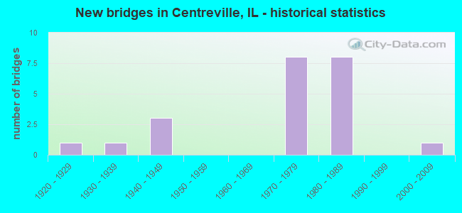
- New bridges - historical statistics
- 11920-1929
- 11930-1939
- 31940-1949
- 81970-1979
- 81980-1989
- 12000-2009

- Reconstructed bridges - Historical Statistics
- 11970-1979
- 11980-1989
- 01990-1999
- 22000-2009


- Bridge Condition - Deck
- 7.7%Excellent
- 30.8%Very good
- 38.5%Good
- 15.4%Satisfactory
- 7.7%Fair

- Bridge Condition - Superstructure
- 7.7%Excellent
- 15.4%Very good
- 30.8%Good
- 30.8%Satisfactory
- 15.4%Fair

- Bridge Condition - Substructure
- 7.7%Excellent
- 30.8%Very good
- 38.5%Good
- 23.1%Satisfactory

- Bridge Condition - Channel
- 11.1%Excellent
- 44.4%Very good
- 22.2%Good
- 11.1%Satisfactory
- 11.1%Poor
Find on map >> Show street view
Structure Number: 820039, Location: 0.3 M W JCT 157 (Lat: 38.570136, Lng: -90.094231), Route carried "on" structure: State highway 15, Year Built: 1940, Year Reconstructed: 1984, Status: Open, Structure Length: 4.79m (15.72ft), Average Daily Traffic: 29,100 (year 2021), Truck Traffic: 10%, Average Future Daily Traffic: 18,776 (year 2032), Design Load: HS 20, Features Intersected: HARDING DITCH
Minimum Vertical Clearance: 30+ m (98+ ft), Kilometerpoint: 9.012, Lanes on structure: 4, Base Highway Network: Yes, Owner: State Highway Agency, Approaching Roadway Width: 19.9m (65.3ft), Skew: 30 degrees, Material/Design: Steel continuous, Design/Construction: Stringer/Multi-beam, Number Of Spans In Main Unit: 3, Length of Maximum Span: 18.3m (60.0ft), Curb-To-Curb Width: 19.9m (65.3ft), Out-to-Out Width: 21.7m (71.2ft)
Condition: Deck: Very good, Superstructure: Good, Substructure: Satisfactory, Channel: Satisfactory, Operating Rating: 54.8 metric tons, Method Used To Determine Operating Rating: Load Factor (LF) rating reported by rating factor (RF) method using MS18 loading, Inventory Rating: 32.7 metric tons, Method Used To Determine Inventory Rating: Load Factor (LF) rating reported by rating factor (RF) method using MS18 loading, Structural Evaluation: Equal to present minimum criteria, Deck Geometry: Better than present minimum criteria, Waterway Adequacy: Equal to present desirable criteria, Approach Roadway Alignment: Equal to present desirable criteria, Designated Inspection Frequency: Every 24 months, Inspection Date: March 2020, Deck Structure Type: Concrete Cast-file-Place, Wearing Surface/Protective System: Wearing Surface: Bituminous, Membrane: Built-up, Deck Protection: Epoxy Coated Reinforcing
Find on map >> Show street view
Structure Number: 82004, Location: 1.8 M E JCT ILL 163 (Lat: 38.567531, Lng: -90.091381), Route carried "on" structure: State highway 15, Year Built: 1940, Year Reconstructed: 1985, Status: Open, Structure Length: 4.97m (16.31ft), Average Daily Traffic: 28,000 (year 2021), Truck Traffic: 9%, Average Future Daily Traffic: 36,296 (year 2032), Design Load: HS 20, Features Intersected: ILL 157
Minimum Vertical Clearance: 30+ m (98+ ft), Kilometerpoint: 9.366, Lanes on structure: 4, Lanes under structure: 2, Base Highway Network: Yes, Owner: State Highway Agency, Approaching Roadway Width: 21.9m (71.9ft), Skew: 30 degrees, Material/Design: Steel continuous, Design/Construction: Stringer/Multi-beam, Number Of Spans In Main Unit: 3, Length of Maximum Span: 18.9m (62.0ft), Curb-To-Curb Width: 19.5m (64.0ft), Out-to-Out Width: 21.7m (71.2ft)
Condition: Deck: Very good, Superstructure: Good, Substructure: Good, Operating Rating: 62.2 metric tons, Method Used To Determine Operating Rating: Load Factor (LF) rating reported by rating factor (RF) method using MS18 loading, Inventory Rating: 37.3 metric tons, Method Used To Determine Inventory Rating: Load Factor (LF) rating reported by rating factor (RF) method using MS18 loading, Structural Evaluation: Better than present minimum criteria, Deck Geometry: Better than present minimum criteria, Underclear: Meets minimum limits, Approach Roadway Alignment: Equal to present desirable criteria, Designated Inspection Frequency: Every 24 months, Inspection Date: March 2020, Deck Structure Type: Concrete Cast-file-Place, Wearing Surface/Protective System: Wearing Surface: Bituminous, Membrane: Built-up, Deck Protection: Epoxy Coated Reinforcing
Find on map >> Show street view
Structure Number: 820212, Location: SE OF JCT IL 163&157 (Lat: 38.561750, Lng: -90.103636), Route carried "on" structure: State highway 13, Year Built: 1973, Year Reconstructed: 2008, Status: Open, Structure Length: 3.49m (11.45ft), Average Daily Traffic: 6,400 (year 2021), Truck Traffic: 5%, Average Future Daily Traffic: 7,061 (year 2032), Design Load: HS 20, Features Intersected: HARDING DITCH
Minimum Vertical Clearance: 30+ m (98+ ft), Kilometerpoint: 0.097, Lanes on structure: 2, Base Highway Network: Yes, Owner: State Highway Agency, Approaching Roadway Width: 10.1m (33.1ft), Material/Design: Prestressed concrete, Design/Construction: Box Beam or Girders - Multiple, Number Of Spans In Main Unit: 3, Length of Maximum Span: 12.9m (42.3ft), Curb-To-Curb Width: 10.1m (33.1ft), Out-to-Out Width: 10.1m (33.1ft)
Condition: Deck: Good, Superstructure: Good, Substructure: Good, Channel: Very good, Operating Rating: 66.4 metric tons, Method Used To Determine Operating Rating: Load Factor (LF) rating reported by rating factor (RF) method using MS18 loading, Inventory Rating: 39.9 metric tons, Method Used To Determine Inventory Rating: Load Factor (LF) rating reported by rating factor (RF) method using MS18 loading, Structural Evaluation: Better than present minimum criteria, Deck Geometry: Meets minimum limits, Waterway Adequacy: Equal to present desirable criteria, Approach Roadway Alignment: Equal to present desirable criteria, Length Of Structure Improvement: 3.60m (11.81ft), Designated Inspection Frequency: Every 48 months, Inspection Date: October 2020, Bridge Improvement Cost: $566,000, Roadway Improvement Cost: $29,000, Total Project Cost: $595,000, Deck Structure Type: Concrete Precast Panels, Wearing Surface/Protective System: Wearing Surface: Integral Concrete
Find on map >> Show street view
Structure Number: 820213, Location: 50 FT E ILL 157 (Lat: 38.556164, Lng: -90.110181), Route carried "on" structure: State highway 163, Year Built: 1975, Year Reconstructed: 2006, Status: Open, Structure Length: 3.88m (12.73ft), Average Daily Traffic: 3,350 (year 2021), Truck Traffic: 9%, Average Future Daily Traffic: 4,393 (year 2032), Design Load: HS 20, Features Intersected: HARDING DITCH
Minimum Vertical Clearance: 30+ m (98+ ft), Kilometerpoint: 11.329, Lanes on structure: 2, Base Highway Network: Yes, Owner: State Highway Agency, Approaching Roadway Width: 12.2m (40.0ft), Skew: 1 degrees, Material/Design: Prestressed concrete, Design/Construction: Box Beam or Girders - Multiple, Number Of Spans In Main Unit: 3, Length of Maximum Span: 13.1m (43.0ft), Curb-To-Curb Width: 9.1m (29.9ft), Out-to-Out Width: 10.2m (33.5ft)
Condition: Deck: Good, Superstructure: Good, Substructure: Satisfactory, Channel: Good, Operating Rating: 68.0 metric tons, Method Used To Determine Operating Rating: Load Factor (LF) rating reported by rating factor (RF) method using MS18 loading, Inventory Rating: 40.2 metric tons, Method Used To Determine Inventory Rating: Load Factor (LF) rating reported by rating factor (RF) method using MS18 loading, Structural Evaluation: Equal to present minimum criteria, Deck Geometry: Meets minimum limits, Waterway Adequacy: Equal to present desirable criteria, Approach Roadway Alignment: Equal to present minimum criteria, Length Of Structure Improvement: 3.87m (12.70ft), Designated Inspection Frequency: Every 24 months, Inspection Date: August 2021, Bridge Improvement Cost: $648,000, Roadway Improvement Cost: $36,000, Total Project Cost: $684,000, Deck Structure Type: Concrete Precast Panels, Wearing Surface/Protective System: Wearing Surface: Low Slump Concrete
Find on map >> Show street view
Structure Number: 820214, Location: 0.17 MI SE ILL 157 (Lat: 38.554492, Lng: -90.108192), Route carried "on" structure: State highway 163, Year Built: 1975, Status: Open, Structure Length: 7.50m (24.61ft), Average Daily Traffic: 3,350 (year 2021), Truck Traffic: 9%, Average Future Daily Traffic: 4,393 (year 2032), Design Load: HS 20, Features Intersected: CANAL NO 1LEVEE DIST
Minimum Vertical Clearance: 30+ m (98+ ft), Kilometerpoint: 11.072, Lanes on structure: 2, Base Highway Network: Yes, Owner: State Highway Agency, Approaching Roadway Width: 12.2m (40.0ft), Material/Design: Prestressed concrete, Design/Construction: Box Beam or Girders - Multiple, Number Of Spans In Main Unit: 6, Length of Maximum Span: 12.8m (42.0ft), Curb-To-Curb Width: 9.9m (32.5ft), Out-to-Out Width: 10.2m (33.5ft)
Condition: Deck: Satisfactory, Superstructure: Satisfactory, Substructure: Satisfactory, Channel: Poor, Operating Rating: 68.7 metric tons, Method Used To Determine Operating Rating: Load Factor (LF) rating reported by rating factor (RF) method using MS18 loading, Inventory Rating: 41.5 metric tons, Method Used To Determine Inventory Rating: Load Factor (LF) rating reported by rating factor (RF) method using MS18 loading, Structural Evaluation: Equal to present minimum criteria, Deck Geometry: Meets minimum limits, Waterway Adequacy: Equal to present minimum criteria, Approach Roadway Alignment: Equal to present desirable criteria, Designated Inspection Frequency: Every 24 months, Inspection Date: August 2021, Deck Structure Type: Concrete Precast Panels, Wearing Surface/Protective System: Wearing Surface: Low Slump Concrete, Deck Protection: Epoxy Coated Reinforcing
Find on map >> Show street view
Structure Number: 820226, Location: 0.4 MI NO DORIS AVE. (Lat: 38.565661, Lng: -90.130161), Route carried "on" structure: Interstate 255, Year Built: 1979, Status: Open, Structure Length: 3.39m (11.12ft), Average Daily Traffic: 45,000 (year 2021), Truck Traffic: 16%, Average Future Daily Traffic: 44,769 (year 2032), Design Load: HS 20+Mod, Features Intersected: MOUSETTE LN-FAU 9200
Minimum Vertical Clearance: 30+ m (98+ ft), Kilometerpoint: 18.153, Lanes on structure: 6, Lanes under structure: 2, Base Highway Network: Yes, Owner: State Highway Agency, Approaching Roadway Width: 34.1m (111.9ft), Skew: 33 degrees, Material/Design: Steel, Design/Construction: Stringer/Multi-beam, Number Of Spans In Main Unit: 1, Number Of Approach Spans: 2, Length of Maximum Span: 33.2m (108.9ft), Curb-To-Curb Width: 35.9m (117.8ft), Out-to-Out Width: 36.9m (121.1ft)
Condition: Deck: Good, Superstructure: Satisfactory, Substructure: Good, Operating Rating: 74.2 metric tons, Method Used To Determine Operating Rating: Load Factor (LF) rating reported by rating factor (RF) method using MS18 loading, Inventory Rating: 44.4 metric tons, Method Used To Determine Inventory Rating: Load Factor (LF) rating reported by rating factor (RF) method using MS18 loading, Structural Evaluation: Equal to present minimum criteria, Deck Geometry: Superior to present desirable criteria, Underclear: Meets minimum limits, Approach Roadway Alignment: Equal to present desirable criteria, Designated Inspection Frequency: Every 24 months, Inspection Date: January 2021, Deck Structure Type: Concrete Cast-file-Place, Wearing Surface/Protective System: Deck Protection: Epoxy Coated Reinforcing
Find on map >> Show street view
Structure Number: 820227, Location: 1.25M SW ILL15&I255 (Lat: 38.570819, Lng: -90.123231), Route carried "on" structure: Interstate 255, Year Built: 1984, Status: Open, Structure Length: 37.37m (122.60ft), Average Daily Traffic: 45,000 (year 2021), Truck Traffic: 16%, Average Future Daily Traffic: 44,769 (year 2032), Design Load: HS 20, Features Intersected: ICG RR& CHURCH RD
Minimum Vertical Clearance: 30+ m (98+ ft), Kilometerpoint: 18.748, Lanes on structure: 6, Lanes under structure: 2, Base Highway Network: Yes, Owner: State Highway Agency, Approaching Roadway Width: 34.1m (111.9ft), Skew: 31 degrees, Material/Design: Steel continuous, Design/Construction: Stringer/Multi-beam, Number Of Spans In Main Unit: 11, Length of Maximum Span: 36.3m (119.1ft), Curb-To-Curb Width: 34.1m (111.9ft), Out-to-Out Width: 36.9m (121.1ft)
Condition: Deck: Good, Superstructure: Fair, Substructure: Good, Operating Rating: 47.0 metric tons, Method Used To Determine Operating Rating: Load Factor (LF) rating reported by rating factor (RF) method using MS18 loading, Inventory Rating: 28.2 metric tons, Method Used To Determine Inventory Rating: Load Factor (LF) rating reported by rating factor (RF) method using MS18 loading, Structural Evaluation: Somewhat better than minimum adequacy, Deck Geometry: Superior to present desirable criteria, Underclear: Somewhat better than minimum adequacy, Approach Roadway Alignment: Equal to present desirable criteria, Designated Inspection Frequency: Every 24 months, Inspection Date: January 2021, Deck Structure Type: Concrete Cast-file-Place, Wearing Surface/Protective System: Wearing Surface: Bituminous, Membrane: Built-up, Deck Protection: Epoxy Coated Reinforcing
Find on map >> Show street view
Structure Number: 820232, Location: S EDGE FHSP (Lat: 38.587939, Lng: -90.098369), Route carried "on" structure: Other road , Year Built: 1981, Status: Open, Structure Length: 5.33m (17.49ft), Average Daily Traffic: 200 (year 2018), Truck Traffic: 3%, Average Future Daily Traffic: 366 (year 2032), Design Load: HS 20, Features Intersected: FAI 255, Facility Carried by Structure: POCKET RD/ FAU 923
Minimum Vertical Clearance: 30+ m (98+ ft), Kilometerpoint: 2.688, Lanes on structure: 2, Lanes under structure: 6, Owner: State Highway Agency, Approaching Roadway Width: 6.7m (22.0ft), Skew: 1 degrees, Material/Design: Steel continuous, Design/Construction: Stringer/Multi-beam, Number Of Spans In Main Unit: 2, Number Of Approach Spans: 2, Length of Maximum Span: 25.0m (82.0ft), Curb or Sidewalk Widths: Left: 1.5m (4.9ft), Right: 0.0m, Curb-To-Curb Width: 9.4m (30.8ft), Out-to-Out Width: 11.8m (38.7ft)
Condition: Deck: Good, Superstructure: Very good, Substructure: Very good, Operating Rating: 89.1 metric tons, Method Used To Determine Operating Rating: Load Factor (LF) rating reported by rating factor (RF) method using MS18 loading, Inventory Rating: 42.8 metric tons, Method Used To Determine Inventory Rating: Load Factor (LF) rating reported by rating factor (RF) method using MS18 loading, Structural Evaluation: Equal to present desirable criteria, Deck Geometry: Equal to present minimum criteria, Underclear: Somewhat better than minimum adequacy, Approach Roadway Alignment: Equal to present desirable criteria, Designated Inspection Frequency: Every 24 months, Inspection Date: January 2021, Deck Structure Type: Concrete Cast-file-Place, Wearing Surface/Protective System: Deck Protection: Epoxy Coated Reinforcing
Find on map >> Show street view
Structure Number: 820233, Location: FRANK HOLTEN ST.PARK (Lat: 38.593533, Lng: -90.091172), Route carried "on" structure: Other road , Year Built: 1981, Status: Open, Structure Length: 13.49m (44.26ft), Average Daily Traffic: 300 (year 2018), Truck Traffic: 8%, Average Future Daily Traffic: 1,055 (year 2032), Design Load: HS 20, Features Intersected: I255 & HARDING DITCH, Facility Carried by Structure: PARK ROAD TR 515A
Minimum Vertical Clearance: 30+ m (98+ ft), Kilometerpoint: 0.949, Lanes on structure: 2, Lanes under structure: 6, Owner: State Highway Agency, Approaching Roadway Width: 6.1m (20.0ft), Material/Design: Steel continuous, Design/Construction: Stringer/Multi-beam, Number Of Spans In Main Unit: 4, Length of Maximum Span: 34.4m (112.9ft), Curb or Sidewalk Widths: Left: 5.2m (17.1ft), Right: 0.0m, Curb-To-Curb Width: 7.9m (25.9ft), Out-to-Out Width: 13.9m (45.6ft)
Condition: Deck: Very good, Superstructure: Satisfactory, Substructure: Very good, Channel: Very good, Operating Rating: 61.2 metric tons, Method Used To Determine Operating Rating: Load Factor (LF) rating reported by rating factor (RF) method using MS18 loading, Inventory Rating: 36.9 metric tons, Method Used To Determine Inventory Rating: Load Factor (LF) rating reported by rating factor (RF) method using MS18 loading, Structural Evaluation: Equal to present minimum criteria, Deck Geometry: Somewhat better than minimum adequacy, Underclear: Somewhat better than minimum adequacy, Waterway Adequacy: Superior to present desirable criteria, Approach Roadway Alignment: Equal to present desirable criteria, Designated Inspection Frequency: Every 24 months, Inspection Date: January 2021, Deck Structure Type: Concrete Cast-file-Place, Wearing Surface/Protective System: Deck Protection: Epoxy Coated Reinforcing
Find on map >> Show street view
Structure Number: 820234, Location: .3 MI E IL 111 (Lat: 38.595619, Lng: -90.089211), Route carried "on" structure: Other road , Year Built: 1981, Status: Open, Structure Length: 18.32m (60.10ft), Average Daily Traffic: 4,650 (year 2018), Truck Traffic: 3%, Average Future Daily Traffic: 4,969 (year 2032), Design Load: HS 20, Features Intersected: FAI 255/HARDING DTCH, Facility Carried by Structure: LAKE DR/ FAU 9185
Minimum Vertical Clearance: 30+ m (98+ ft), Kilometerpoint: 4.313, Lanes on structure: 2, Lanes under structure: 6, Owner: State Highway Agency, Approaching Roadway Width: 6.1m (20.0ft), Skew: 4 degrees, Material/Design: Steel continuous, Design/Construction: Stringer/Multi-beam, Number Of Spans In Main Unit: 5, Length of Maximum Span: 45.4m (149.0ft), Curb or Sidewalk Widths: Left: 1.5m (4.9ft), Right: 1.5m (4.9ft), Curb-To-Curb Width: 9.1m (29.9ft), Out-to-Out Width: 12.8m (42.0ft)
Condition: Deck: Very good, Superstructure: Very good, Substructure: Very good, Channel: Very good, Operating Rating: 61.9 metric tons, Method Used To Determine Operating Rating: Load Factor (LF) rating reported by rating factor (RF) method using MS18 loading, Inventory Rating: 36.9 metric tons, Method Used To Determine Inventory Rating: Load Factor (LF) rating reported by rating factor (RF) method using MS18 loading, Structural Evaluation: Equal to present desirable criteria, Deck Geometry: Meets minimum limits, Underclear: Meets minimum limits, Waterway Adequacy: Superior to present desirable criteria, Approach Roadway Alignment: Equal to present desirable criteria, Designated Inspection Frequency: Every 24 months, Inspection Date: January 2021, Deck Structure Type: Concrete Cast-file-Place, Wearing Surface/Protective System: Wearing Surface: Bituminous, Membrane: Built-up, Deck Protection: Epoxy Coated Reinforcing
Find on map >> Show street view
Structure Number: 820257, Location: .11 MI W IL 157 (Lat: 38.580039, Lng: -90.078114), Route carried "on" structure: Other road , Year Built: 1978, Status: Open, Structure Length: 3.96m (12.99ft), Average Daily Traffic: 4,550 (year 2018), Truck Traffic: 2%, Average Future Daily Traffic: 4,289 (year 2032), Design Load: HS 20, Features Intersected: CANAL #1 LEVEE DIST, Facility Carried by Structure: LAKE DR/ FAU 9185
Minimum Vertical Clearance: 30+ m (98+ ft), Kilometerpoint: 6.389, Lanes on structure: 2, Owner: State Highway Agency, Approaching Roadway Width: 26.2m (86.0ft), Skew: 30 degrees, Material/Design: Prestressed concrete, Design/Construction: Stringer/Multi-beam, Number Of Spans In Main Unit: 3, Length of Maximum Span: 12.8m (42.0ft), Curb-To-Curb Width: 25.8m (84.6ft), Out-to-Out Width: 27.0m (88.6ft)
Condition: Deck: Satisfactory, Superstructure: Satisfactory, Substructure: Good, Channel: Very good, Operating Rating: 75.8 metric tons, Method Used To Determine Operating Rating: Load Factor (LF) rating reported by rating factor (RF) method using MS18 loading, Inventory Rating: 51.5 metric tons, Method Used To Determine Inventory Rating: Load Factor (LF) rating reported by rating factor (RF) method using MS18 loading, Structural Evaluation: Equal to present minimum criteria, Deck Geometry: Superior to present desirable criteria, Waterway Adequacy: Equal to present desirable criteria, Approach Roadway Alignment: Equal to present minimum criteria, Designated Inspection Frequency: Every 24 months, Inspection Date: August 2020, Deck Structure Type: Concrete Cast-file-Place, Wearing Surface/Protective System: Wearing Surface: Bituminous, Membrane: Built-up
Find on map >> Show street view
Structure Number: 822564, Location: 2.5 MI NW OF IL 157 (Lat: 38.605411, Lng: -90.106700), Route carried "on" structure: Other road , Year Built: 1929, Status: Open, Structure Length: 0.77m (2.53ft), Average Daily Traffic: 3,700 (year 2018), Truck Traffic: 3%, Average Future Daily Traffic: 3,766 (year 2032), Design Load: HS 20, Features Intersected: DRAINGE TO FHSP LAKE, Facility Carried by Structure: LAKE DRIVE
Minimum Vertical Clearance: 30+ m (98+ ft), Kilometerpoint: 2.446, Lanes on structure: 2, Owner: State Highway Agency, Approaching Roadway Width: 7.3m (24.0ft), Material/Design: Concrete, Design/Construction: Culvert, Number Of Spans In Main Unit: 3, Length of Maximum Span: 1.7m (5.6ft)
Condition: Channel: Good, Culverts: Satisfactory, Operating Rating: 54.1 metric tons, Method Used To Determine Operating Rating: Load Factor (LF) rating reported by rating factor (RF) method using MS18 loading, Inventory Rating: 32.4 metric tons, Method Used To Determine Inventory Rating: Load Factor (LF) rating reported by rating factor (RF) method using MS18 loading, Structural Evaluation: Equal to present minimum criteria, Waterway Adequacy: Equal to present desirable criteria, Approach Roadway Alignment: Equal to present desirable criteria, Designated Inspection Frequency: Every 24 months, Inspection Date: August 2020
Find on map >> Show street view
Structure Number: 8265, Location: CENTREVILLE (Lat: 38.606694, Lng: -90.111258), Route carried "on" structure: Other road , Year Built: 1976, Status: Open, Structure Length: 6.98m (22.90ft), Average Daily Traffic: 3,700 (year 2018), Truck Traffic: 3%, Average Future Daily Traffic: 4,393 (year 2032), Design Load: HS 20, Features Intersected: A&S RR AND 43RD ST, Facility Carried by Structure: LAKE DR FAU 9185
Minimum Vertical Clearance: 30+ m (98+ ft), Kilometerpoint: 1.996, Lanes on structure: 2, Lanes under structure: 2, Owner: City or Municipal Highway Agency, Approaching Roadway Width: 10.4m (34.1ft), Material/Design: Steel continuous, Design/Construction: Stringer/Multi-beam, Number Of Spans In Main Unit: 4, Length of Maximum Span: 18.6m (61.0ft), Curb-To-Curb Width: 13.4m (44.0ft), Out-to-Out Width: 14.4m (47.2ft)
Condition: Deck: Fair, Superstructure: Fair, Substructure: Very good, Operating Rating: 36.6 metric tons, Method Used To Determine Operating Rating: Load Factor (LF) rating reported by rating factor (RF) method using MS18 loading, Inventory Rating: 21.7 metric tons, Method Used To Determine Inventory Rating: Load Factor (LF) rating reported by rating factor (RF) method using MS18 loading, Structural Evaluation: Somewhat better than minimum adequacy, Deck Geometry: Better than present minimum criteria, Underclear: Equal to present minimum criteria, Approach Roadway Alignment: Equal to present desirable criteria, Designated Inspection Frequency: Every 24 months, Inspection Date: April 2020, Deck Structure Type: Concrete Cast-file-Place
Find on map >> Show street view
Structure Number: 82906, Location: FRANK HOLTEN ST. PK. (Lat: 38.598783, Lng: -90.099647), Route carried "on" structure: Other road , Year Built: 2004, Status: Open, Structure Length: 1.98m (6.50ft), Average Daily Traffic: 700 (year 2018), Truck Traffic: 1%, Average Future Daily Traffic: 742 (year 2032), Design Load: HS 20, Features Intersected: WHISPERING WILLOW LK, Facility Carried by Structure: PARK ACCESS ROAD
Minimum Vertical Clearance: 2.95m (9.68ft), Kilometerpoint: 0.177, Lanes on structure: 2, Owner: State Park, Forest, or Reservation Agency, Approaching Roadway Width: 12.2m (40.0ft), Material/Design: Prestressed concrete, Design/Construction: Box Beam or Girders - Multiple, Number Of Spans In Main Unit: 1, Number Of Approach Spans: 2, Length of Maximum Span: 19.4m (63.6ft), Curb or Sidewalk Widths: Left: 1.5m (4.9ft), Right: 1.5m (4.9ft), Curb-To-Curb Width: 8.5m (27.9ft), Out-to-Out Width: 12.2m (40.0ft)
Condition: Deck: Excellent, Superstructure: Excellent, Substructure: Excellent, Channel: Excellent, Operating Rating: 53.8 metric tons, Method Used To Determine Operating Rating: Field evaluation and documented engineering judgment, Inventory Rating: 32.4 metric tons, Method Used To Determine Inventory Rating: Field evaluation and documented engineering judgment, Structural Evaluation: Equal to present desirable criteria, Deck Geometry: High priority of corrective action, Waterway Adequacy: Superior to present desirable criteria, Approach Roadway Alignment: Superior to present desirable criteria, Designated Inspection Frequency: Every 24 months, Inspection Date: Febuary 2019, Deck Structure Type: Concrete Precast Panels, Wearing Surface/Protective System: Wearing Surface: Bituminous
Find on map >> Show street view
Structure Number: 82004, Location: 1.8 M E JCT ILL 163 (Lat: 38.567531, Lng: -90.091381), Route carried "under" structure: State highway 157, Year Built: 1940, Structure Length: 0. m, Average Daily Traffic: 6,900 (year 2021), Truck Traffic: 9%, Features Intersected: ILL 157, Facility Carried by Structure: ILL 15
Minimum Vertical Clearance: 4.95m (16.24ft), Kilometerpoint: 10.879, Lanes on structure: 4, Lanes under structure: 2, Material/Design: Steel continuous, Design/Construction: Stringer/Multi-beam, Length of Maximum Span: 18.9m (62.0ft)
Find on map >> Show street view
Structure Number: 820226, Location: 0.4 MI NO DORIS AVE. (Lat: 38.565661, Lng: -90.130161), Route carried "under" structure: Other road , Year Built: 1979, Structure Length: 0. m, Average Daily Traffic: 2,950 (year 2018), Truck Traffic: 6%, Features Intersected: MOUSETTE LN-FAU 9200, Facility Carried by Structure: FAI 255
Minimum Vertical Clearance: 4.57m (14.99ft), Kilometerpoint: 2.575, Lanes on structure: 6, Lanes under structure: 2, Material/Design: Steel, Design/Construction: Stringer/Multi-beam, Length of Maximum Span: 33.2m (108.9ft)
Find on map >> Show street view
Structure Number: 820227, Location: 1.25M SW ILL15&I255 (Lat: 38.570819, Lng: -90.123231), Route carried "under" structure: Other road , Year Built: 1984, Structure Length: 0. m, Average Daily Traffic: 1,250 (year 2018), Truck Traffic: 14%, Features Intersected: ICG RR& CHURCH RD, Facility Carried by Structure: FAI 255
Minimum Vertical Clearance: 8.86m (29.07ft), Kilometerpoint: 0.290, Lanes on structure: 6, Lanes under structure: 2, Material/Design: Steel continuous, Design/Construction: Stringer/Multi-beam, Length of Maximum Span: 36.3m (119.1ft)
Find on map >> Show street view
Structure Number: 820232, Location: S EDGE FHSP (Lat: 38.587939, Lng: -90.098369), Route carried "under" structure: Interstate 255, Year Built: 1981, Structure Length: 0. m, Average Daily Traffic: 47,800 (year 2021), Truck Traffic: 17%, Features Intersected: FAI 255, Facility Carried by Structure: POCKET RD/ FAU 923
Minimum Vertical Clearance: 4.98m (16.34ft), Kilometerpoint: 21.919, Lanes on structure: 2, Lanes under structure: 6, Material/Design: Steel continuous, Design/Construction: Stringer/Multi-beam, Length of Maximum Span: 25.0m (82.0ft)
Find on map >> Show street view
Structure Number: 820233, Location: FRANK HOLTEN ST.PARK (Lat: 38.593300, Lng: -90.090661), Route carried "under" structure: Interstate 255, Year Built: 1981, Structure Length: 0. m, Average Daily Traffic: 47,800 (year 2021), Truck Traffic: 17%, Features Intersected: I255 & HARDING DITCH, Facility Carried by Structure: PARK ROAD TR 515A
Minimum Vertical Clearance: 5.05m (16.57ft), Kilometerpoint: 22.820, Lanes on structure: 2, Lanes under structure: 6, Material/Design: Steel continuous, Design/Construction: Stringer/Multi-beam, Length of Maximum Span: 34.4m (112.9ft)
Find on map >> Show street view
Structure Number: 820234, Location: .3 MI E IL 111 (Lat: 38.595619, Lng: -90.089211), Route carried "under" structure: Interstate 255, Year Built: 1981, Structure Length: 0. m, Average Daily Traffic: 47,800 (year 2021), Truck Traffic: 17%, Features Intersected: FAI 255/HARDING DTCH, Facility Carried by Structure: LAKE DR/ FAU 9185
Minimum Vertical Clearance: 5.26m (17.26ft), Kilometerpoint: 23.110, Lanes on structure: 2, Lanes under structure: 6, Material/Design: Steel continuous, Design/Construction: Stringer/Multi-beam, Length of Maximum Span: 45.4m (149.0ft)
Find on map >> Show street view
Structure Number: 8265, Location: CENTREVILLE (Lat: 38.606694, Lng: -90.111258), Route carried "under" structure: Other road , Year Built: 1976, Structure Length: 0. m, Average Daily Traffic: 1,750 (year 2018), Truck Traffic: 7%, Features Intersected: A&S RR AND 43RD ST, Facility Carried by Structure: LAKE DR FAU 9185
Minimum Vertical Clearance: 7.32m (24.02ft), Kilometerpoint: 0.241, Lanes on structure: 2, Lanes under structure: 2, Material/Design: Steel continuous, Design/Construction: Stringer/Multi-beam, Length of Maximum Span: 18.6m (61.0ft)
Find on map >> Show street view
Structure Number: 829952, Location: 0.35 M S ILL 157 (Lat: 38.554875, Lng: -90.096867), Route carried "under" structure: State highway 13, Year Built: 1930, Structure Length: 0. m, Average Daily Traffic: 3,550 (year 2021), Truck Traffic: 8%, Features Intersected: ILL 13/ FAU 9251, Facility Carried by Structure: IC RR
Minimum Vertical Clearance: 4.29m (14.07ft), Kilometerpoint: 1.094, Lanes under structure: 2, Material/Design: Concrete, Design/Construction: Slab, Length of Maximum Span: 16.5m (54.1ft)