Bridge Statistics for Central Valley, New York (NY)
Condition, Traffic, Stress, Structural Evaluation, Project Costs
- National Bridge Inventory (NBI) Statistics
- 13Number of bridges
- 56ft / 17.2mTotal length
- $18,568,000Total costs
- 149,012Total average daily traffic
- 7,837Total average daily truck traffic
- National Bridge Inventory (NBI) Registered Bridges for Central Valley
- No street view available for this location
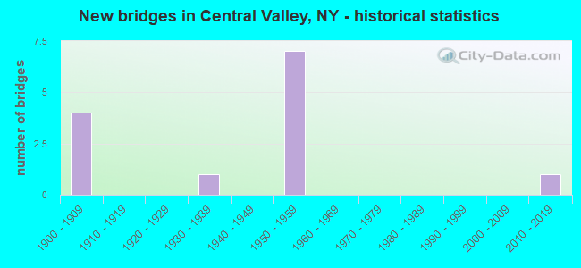
- New bridges - historical statistics
- 41900-1909
- 11930-1939
- 71950-1959
- 12010-2019
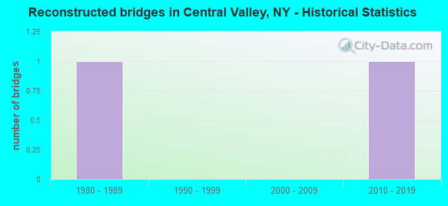
- Reconstructed bridges - Historical Statistics
- 11980-1989
- 01990-1999
- 02000-2009
- 12010-2019

- Bridge Condition - Deck
- 16.7%Good
- 50.0%Satisfactory
- 16.7%Poor
- 16.7%Serious
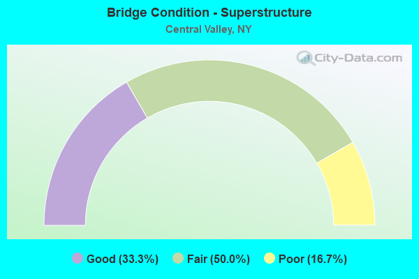
- Bridge Condition - Superstructure
- 33.3%Good
- 50.0%Fair
- 16.7%Poor
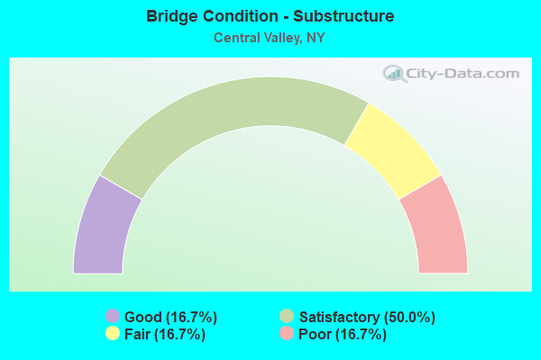
- Bridge Condition - Substructure
- 16.7%Good
- 50.0%Satisfactory
- 16.7%Fair
- 16.7%Poor
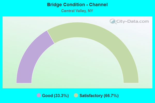
- Bridge Condition - Channel
- 33.3%Good
- 66.7%Satisfactory
Find on map >> Show street view
Structure Number: 200336, Location: 2000' SE JCT Rt.32 & CR 9 (Lat: 41.327467, Lng: -74.115144), Route carried "on" structure: Other road , Year Built: 2011, Status: Open, Structure Length: 0.85m (2.79ft), Average Daily Traffic: 652 (year 2019), Truck Traffic: 3%, Average Future Daily Traffic: 913 (year 2039), Design Load: HS 25 or greater, Features Intersected: WOODBURY CREEK, Facility Carried by Structure: ESTRADA ROAD
Minimum Vertical Clearance: 30+ m (98+ ft), Kilometerpoint: 0.628, Lanes on structure: 2, Owner: Town or Township Highway Agency, Approaching Roadway Width: 7.6m (24.9ft), Skew: 1 degrees, Material/Design: Concrete, Design/Construction: Frame, Number Of Spans In Main Unit: 1, Length of Maximum Span: 7.9m (25.9ft), Curb or Sidewalk Widths: Left: 0.0m, Right: 0.9m (3.0ft), Curb-To-Curb Width: 6.4m (21.0ft), Out-to-Out Width: 7.9m (25.9ft)
Condition: Deck: Good, Superstructure: Good, Substructure: Satisfactory, Channel: Satisfactory, Operating Rating: 78.9 metric tons, Method Used To Determine Operating Rating: Load Factor (LF), Inventory Rating: 47.2 metric tons, Method Used To Determine Inventory Rating: Load Factor (LF), Structural Evaluation: Equal to present minimum criteria, Deck Geometry: High priority of corrective action, Waterway Adequacy: Equal to present minimum criteria, Approach Roadway Alignment: Equal to present desirable criteria, Length Of Structure Improvement: 0.85m (2.79ft), Designated Inspection Frequency: Every 24 months, Inspection Date: May 2021, Bridge Improvement Cost: $247,000, Roadway Improvement Cost: $145,000, Total Project Cost: $392,000 ( Estimate for 2021)
Find on map >> Show street view
Structure Number: 334541, Location: IN CENTRAL VALLEY (Lat: 41.333969, Lng: -74.118314), Route carried "on" structure: County highway , Year Built: 1935, Year Reconstructed: 1993, Status: Open, Structure Length: 0.79m (2.59ft), Average Daily Traffic: 3,822 (year 2020), Truck Traffic: 2%, Average Future Daily Traffic: 4,728 (year 2040), Design Load: HS 20, Features Intersected: WOODBURY CREEK, Facility Carried by Structure: SMITH CLOVE ROAD
Minimum Vertical Clearance: 30+ m (98+ ft), Kilometerpoint: 0.000, Lanes on structure: 2, Owner: County Highway Agency, Approaching Roadway Width: 7.9m (25.9ft), Material/Design: Prestressed concrete, Design/Construction: Box Beam or Girders - Multiple, Number Of Spans In Main Unit: 1, Length of Maximum Span: 7.3m (24.0ft), Curb or Sidewalk Widths: Left: 2.0m (6.6ft), Right: 1.8m (5.9ft), Curb-To-Curb Width: 7.6m (24.9ft), Out-to-Out Width: 12.3m (40.4ft)
Condition: Deck: Satisfactory, Superstructure: Good, Substructure: Satisfactory, Channel: Good, Operating Rating: 87.1 metric tons, Method Used To Determine Operating Rating: Load Factor (LF), Inventory Rating: 51.7 metric tons, Method Used To Determine Inventory Rating: Load Factor (LF), Structural Evaluation: Equal to present minimum criteria, Deck Geometry: High priority of replacement, Waterway Adequacy: Somewhat better than minimum adequacy, Approach Roadway Alignment: Equal to present desirable criteria, Length Of Structure Improvement: 0.79m (2.59ft), Designated Inspection Frequency: Every 24 months, Inspection Date: June 2021, Bridge Improvement Cost: $405,000, Roadway Improvement Cost: $237,000, Total Project Cost: $641,000 ( Estimate for 2021), Wearing Surface/Protective System: Wearing Surface: Bituminous, Membrane: Other
Find on map >> Show street view
Structure Number: 334542, Location: 0.4 MI SE OF HIGHL. MILLS (Lat: 41.344594, Lng: -74.121014), Route carried "on" structure: Other road , Year Built: 1953, Status: Open, Structure Length: 1.28m (4.20ft), Average Daily Traffic: 999 (year 2020), Truck Traffic: 3%, Average Future Daily Traffic: 1,236 (year 2040), Design Load: H 20, Features Intersected: WOODBURY CREEK, Facility Carried by Structure: PARK AVENUE
Minimum Vertical Clearance: 30+ m (98+ ft), Kilometerpoint: 0.499, Lanes on structure: 2, Owner: County Highway Agency, Approaching Roadway Width: 6.1m (20.0ft), Material/Design: Steel, Design/Construction: Stringer/Multi-beam, Number Of Spans In Main Unit: 1, Length of Maximum Span: 11.5m (37.7ft), Curb-To-Curb Width: 6.7m (22.0ft), Out-to-Out Width: 7.6m (24.9ft)
Condition: Deck: Poor, Superstructure: Fair, Substructure: Satisfactory, Channel: Satisfactory, Operating Rating: 32.4 metric tons, Method Used To Determine Operating Rating: Load and Resistance Factor Rating (LRFR) rating reported by rating factor(RF) method using HL-93 loadings, Inventory Rating: 24.9 metric tons, Method Used To Determine Inventory Rating: Load and Resistance Factor Rating (LRFR) rating reported by rating factor(RF) method using HL-93 loadings, Structural Evaluation: Somewhat better than minimum adequacy, Deck Geometry: Meets minimum limits, Waterway Adequacy: High priority of corrective action, Approach Roadway Alignment: High priority of corrective action, Length Of Structure Improvement: 1.28m (4.20ft), Designated Inspection Frequency: Every 24 months, Inspection Date: June 2020, Bridge Improvement Cost: $590,000, Roadway Improvement Cost: $345,000, Total Project Cost: $935,000 ( Estimate for 2021), Deck Structure Type: Concrete Cast-file-Place, Wearing Surface/Protective System: Wearing Surface: Bituminous
Find on map >> Show street view
Structure Number: 500337, Location: 1.6 MI N INT US-6 and I87 (Lat: 41.326342, Lng: -74.112622), Route carried "on" structure: Other road , Year Built: 1953, Year Reconstructed: 2016, Status: Open, Structure Length: 6.86m (22.51ft), Average Daily Traffic: 652 (year 2019), Truck Traffic: 3%, Average Future Daily Traffic: 913 (year 2039), Design Load: HS 20, Features Intersected: 87IX SB, RTE I87, Facility Carried by Structure: ESTRADA RD
Minimum Vertical Clearance: 30.18m (99.02ft), Kilometerpoint: 0.837, Lanes on structure: 2, Lanes under structure: 4, Owner: State Toll Authority, Approaching Roadway Width: 7.6m (24.9ft), Skew: 2 degrees, Material/Design: Steel, Design/Construction: Stringer/Multi-beam, Number Of Spans In Main Unit: 4, Length of Maximum Span: 19.8m (65.0ft), Curb or Sidewalk Widths: Left: 0.8m (2.6ft), Right: 0.8m (2.6ft), Curb-To-Curb Width: 11.0m (36.1ft), Out-to-Out Width: 13.0m (42.7ft)
Condition: Deck: Satisfactory, Superstructure: Fair, Substructure: Good, Operating Rating: 84.4 metric tons, Method Used To Determine Operating Rating: Load Factor (LF), Inventory Rating: 50.8 metric tons, Method Used To Determine Inventory Rating: Load Factor (LF), Structural Evaluation: Somewhat better than minimum adequacy, Deck Geometry: Better than present minimum criteria, Underclear: High priority of corrective action, Approach Roadway Alignment: Equal to present desirable criteria, Length Of Structure Improvement: 6.85m (22.47ft), Designated Inspection Frequency: Every 24 months, Inspection Date: November 2020, Bridge Improvement Cost: $3,369,000, Roadway Improvement Cost: $1,973,000, Total Project Cost: $5,343,000 ( Estimate for 2021), Deck Structure Type: Concrete Cast-file-Place, Wearing Surface/Protective System: Wearing Surface: Bituminous
Find on map >> Show street view
Structure Number: 5514279, Location: 2.2 MI N. U.S. RTE 6/I-87 (Lat: 41.335017, Lng: -74.115625), Route carried "on" structure: Interstate 87, Year Built: 1953, Status: Open, Structure Length: 1.55m (5.09ft), Average Daily Traffic: 39,792 (year 2018), Truck Traffic: 19%, Average Future Daily Traffic: 67,383 (year 2040), Design Load: HS 20+Mod, Features Intersected: COUNTY ROUTE 9
Minimum Vertical Clearance: 30+ m (98+ ft), Kilometerpoint: 18.906, Lanes on structure: 4, Lanes under structure: 2, Toll: On Interstate toll segment, Owner: State Toll Authority, Approaching Roadway Width: 23.2m (76.1ft), Skew: 20 degrees, Material/Design: Steel, Design/Construction: Stringer/Multi-beam, Number Of Spans In Main Unit: 1, Length of Maximum Span: 14.3m (46.9ft), Curb-To-Curb Width: 33.2m (108.9ft), Out-to-Out Width: 34.4m (112.9ft)
Condition: Deck: Satisfactory, Superstructure: Fair, Substructure: Fair, Operating Rating: 88.9 metric tons, Method Used To Determine Operating Rating: Load Factor (LF), Inventory Rating: 53.5 metric tons, Method Used To Determine Inventory Rating: Load Factor (LF), Structural Evaluation: Somewhat better than minimum adequacy, Deck Geometry: Superior to present desirable criteria, Underclear: Somewhat better than minimum adequacy, Approach Roadway Alignment: Equal to present desirable criteria, Length Of Structure Improvement: 1.55m (5.09ft), Designated Inspection Frequency: Every 24 months, Inspection Date: April 2021, Bridge Improvement Cost: $4,742,000, Roadway Improvement Cost: $2,777,000, Total Project Cost: $7,519,000 ( Estimate for 2021), Deck Structure Type: Concrete Cast-file-Place, Wearing Surface/Protective System: Wearing Surface: Bituminous
Find on map >> Show street view
Structure Number: 551428, Location: 0.6 MI SE OF HIGHL. MILLS (Lat: 41.342775, Lng: -74.117414), Route carried "on" structure: Other road , Year Built: 1953, Status: Open, Structure Length: 5.91m (19.39ft), Average Daily Traffic: 999 (year 2020), Truck Traffic: 3%, Average Future Daily Traffic: 1,236 (year 2040), Design Load: HS 20, Features Intersected: 87IX, RTE I87, Facility Carried by Structure: PINE HILL ROAD
Minimum Vertical Clearance: 32.69m (107.25ft), Kilometerpoint: 0.515, Lanes on structure: 2, Lanes under structure: 4, Owner: State Toll Authority, Approaching Roadway Width: 8.1m (26.6ft), Material/Design: Steel, Design/Construction: Stringer/Multi-beam, Number Of Spans In Main Unit: 4, Length of Maximum Span: 18.0m (59.1ft), Curb or Sidewalk Widths: Left: 0.8m (2.6ft), Right: 0.8m (2.6ft), Curb-To-Curb Width: 7.9m (25.9ft), Out-to-Out Width: 10.1m (33.1ft)
Condition: Deck: Serious, Superstructure: Poor, Substructure: Poor, Operating Rating: 60.9 metric tons, Method Used To Determine Operating Rating: Load and Resistance Factor Rating (LRFR) rating reported by rating factor(RF) method using HL-93 loadings, Inventory Rating: 47.0 metric tons, Method Used To Determine Inventory Rating: Load and Resistance Factor Rating (LRFR) rating reported by rating factor(RF) method using HL-93 loadings, Structural Evaluation: Meets minimum limits, Deck Geometry: Somewhat better than minimum adequacy, Underclear: High priority of corrective action, Approach Roadway Alignment: Equal to present minimum criteria, Length Of Structure Improvement: 5.91m (19.39ft), Designated Inspection Frequency: Every 12 months, Inspection Date: July 2021, Bridge Improvement Cost: $2,357,000, Roadway Improvement Cost: $1,380,000, Total Project Cost: $3,738,000 ( Estimate for 2021), Deck Structure Type: Concrete Cast-file-Place, Wearing Surface/Protective System: Wearing Surface: Bituminous
Find on map >> Show street view
Structure Number: 500337, Location: 1.6 MI N INT US-6 and I87 (Lat: 41.326342, Lng: -74.112622), Route carried "under" structure: Interstate 87, Year Built: 1953, Structure Length: 0. m, Average Daily Traffic: 48,019 (year 2015), Features Intersected: 87IX SB, RTE I87, Facility Carried by Structure: ESTRADA RD
Minimum Vertical Clearance: 4.60m (15.09ft), Kilometerpoint: 74.690, Lanes on structure: 2, Lanes under structure: 2, Toll: On Interstate toll segment, Material/Design: Steel, Design/Construction: Stringer/Multi-beam, Length of Maximum Span: 19.8m (65.0ft)
Find on map >> Show street view
Structure Number: 5514279, Location: 2.2 MI N. U.S. RTE 6/I-87 (Lat: 41.335017, Lng: -74.115625), Route carried "under" structure: County highway , Year Built: 1953, Structure Length: 0. m, Average Daily Traffic: 3,822 (year 2020), Truck Traffic: 2%, Features Intersected: COUNTY ROUTE 9, Facility Carried by Structure: RTE I87
Minimum Vertical Clearance: 4.47m (14.67ft), Kilometerpoint: 0.274, Lanes on structure: 4, Lanes under structure: 2, Material/Design: Steel, Design/Construction: Stringer/Multi-beam, Length of Maximum Span: 14.3m (46.9ft)
Find on map >> Show street view
Structure Number: 551428, Location: 0.6 MI SE OF HIGHL. MILLS (Lat: 41.342775, Lng: -74.117414), Route carried "under" structure: Interstate 87, Year Built: 1953, Structure Length: 0. m, Average Daily Traffic: 48,006 (year 2014), Features Intersected: 87IX, RTE I87, Facility Carried by Structure: PINE HILL ROAD
Minimum Vertical Clearance: 5.28m (17.32ft), Kilometerpoint: 76.556, Lanes on structure: 2, Lanes under structure: 2, Toll: On Interstate toll segment, Material/Design: Steel, Design/Construction: Stringer/Multi-beam, Length of Maximum Span: 18.0m (59.1ft)
Find on map >> Show street view
Structure Number: 700335, Location: 0.4 MI E OF CENTRL VALLEY (Lat: 41.328789, Lng: -74.117808), Route carried "under" structure: Other road , Year Built: 1908, Structure Length: 0. m, Average Daily Traffic: 200 (year 2021), Features Intersected: ESTRADA ROAD, Facility Carried by Structure: NORFOLK SOUTHERN
Minimum Vertical Clearance: 3.25m (10.66ft), Kilometerpoint: 0.000, Lanes under structure: 2, Material/Design: Steel, Design/Construction: Girder and Floorbeam System, Length of Maximum Span: 8.8m (28.9ft)
Find on map >> Show street view
Structure Number: 771227, Location: 1 MI N OF CENTRAL VALLEY (Lat: 41.342861, Lng: -74.120122), Route carried "under" structure: Other road , Year Built: 1908, Structure Length: 0. m, Average Daily Traffic: 999 (year 2020), Truck Traffic: 3%, Features Intersected: PINE HILL ROAD, Facility Carried by Structure: MNRR PJ LINE
Minimum Vertical Clearance: 3.99m (13.09ft), Kilometerpoint: 0.000, Lanes under structure: 2, Material/Design: Steel, Design/Construction: Girder and Floorbeam System, Length of Maximum Span: 7.9m (25.9ft)
Find on map >> Show street view
Structure Number: 771228, Location: IN CENTRAL VALLEY (Lat: 41.333867, Lng: -74.118447), Route carried "under" structure: County highway , Year Built: 1908, Structure Length: 0. m, Average Daily Traffic: 1,000 (year 2021), Features Intersected: SMITH CLOVE R CR9, Facility Carried by Structure: MNRR PJ LINE
Minimum Vertical Clearance: 3.99m (13.09ft), Kilometerpoint: 0.000, Lanes under structure: 2, Material/Design: Steel continuous, Design/Construction: Girder and Floorbeam System, Length of Maximum Span: 9.4m (30.8ft)
Find on map >> Show street view
Structure Number: 771297, Location: IN CENTRAL VALLEY (Lat: 41.331778, Lng: -74.118056), Route carried "under" structure: Other road , Year Built: 1908, Structure Length: 0. m, Average Daily Traffic: 50 (year 2021), Features Intersected: LAURA LANE, Facility Carried by Structure: MNRR PJ LINE
Minimum Vertical Clearance: 2.87m (9.42ft), Kilometerpoint: 0.000, Lanes under structure: 2, Material/Design: Steel, Design/Construction: Girder and Floorbeam System, Length of Maximum Span: 7.9m (25.9ft)