Bridge Statistics for Centerville, Pennsylvania (PA)
Condition, Traffic, Stress, Structural Evaluation, Project Costs
- National Bridge Inventory (NBI) Statistics
- 32Number of bridges
- 643ft / 196mTotal length
- $1,420,000Total costs
- 38,970Total average daily traffic
- 3,037Total average daily truck traffic
- National Bridge Inventory (NBI) Registered Bridges for Centerville
- No street view available for this location
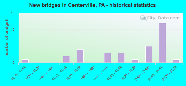
- New bridges - historical statistics
- 11910-1919
- 21940-1949
- 41950-1959
- 31970-1979
- 31980-1989
- 11990-1999
- 52000-2009
- 122010-2019
- 12020-2022

- Reconstructed bridges - Historical Statistics
- 11920-1929
- 01930-1939
- 21940-1949
- 01950-1959
- 01960-1969
- 01970-1979
- 01980-1989
- 11990-1999


- Bridge Condition - Deck
- 4.8%Excellent
- 9.5%Very good
- 42.9%Good
- 28.6%Satisfactory
- 9.5%Fair
- 4.8%Poor

- Bridge Condition - Superstructure
- 4.8%Excellent
- 38.1%Very good
- 19.0%Good
- 19.0%Satisfactory
- 19.0%Fair

- Bridge Condition - Substructure
- 14.3%Very good
- 33.3%Good
- 42.9%Satisfactory
- 9.5%Fair

- Bridge Condition - Channel
- 14.3%Excellent
- 4.8%Very good
- 23.8%Good
- 19.0%Satisfactory
- 33.3%Fair
- 4.8%Poor

- Bridge Condition - Culverts
- 25.0%Very good
- 50.0%Good
- 25.0%Poor
Find on map >> Show street view
Structure Number: 13196, Location: CENTERVILLE BOROUGH (Lat: 41.735953, Lng: -79.767169), Route carried "on" structure: State highway , Year Built: 1956, Status: Open, Structure Length: 1.86m (6.10ft), Average Daily Traffic: 544 (year 2022), Truck Traffic: 6%, Average Future Daily Traffic: 679 (year 2032), Design Load: HS 20, Features Intersected: OVER OIL CREEK, Facility Carried by Structure: SR 1022,COOLEY-CEN
Minimum Vertical Clearance: 30+ m (98+ ft), Kilometerpoint: 9.146, Lanes on structure: 2, Owner: State Highway Agency, Approaching Roadway Width: 6.1m (20.0ft), Material/Design: Steel, Design/Construction: Stringer/Multi-beam, Number Of Spans In Main Unit: 1, Length of Maximum Span: 17.7m (58.1ft), Curb or Sidewalk Widths: Left: 0.2m (0.7ft), Right: 0.2m (0.7ft), Curb-To-Curb Width: 9.1m (29.9ft), Out-to-Out Width: 10.1m (33.1ft)
Condition: Deck: Poor, Superstructure: Fair, Substructure: Satisfactory, Channel: Fair, Operating Rating: 58.1 metric tons, Method Used To Determine Operating Rating: Load Factor (LF), Inventory Rating: 34.5 metric tons, Method Used To Determine Inventory Rating: Load Factor (LF), Structural Evaluation: Somewhat better than minimum adequacy, Deck Geometry: Equal to present minimum criteria, Waterway Adequacy: Equal to present minimum criteria, Approach Roadway Alignment: Equal to present desirable criteria, Length Of Structure Improvement: 2.50m (8.20ft), Designated Inspection Frequency: Every 24 months, Underwater Inspection Frequency: Every 24 months, Inspection Date: September 2021, Underwater Inspection Date: April 2020, Bridge Improvement Cost: $4,000, Roadway Improvement Cost: $12,000, Total Project Cost: $54,000, Deck Structure Type: Concrete Cast-file-Place, Wearing Surface/Protective System: Wearing Surface: Bituminous, Membrane: Preformed Fabric
Find on map >> Show street view
Structure Number: 13197, Location: CENTERVILLE BOROUGH (Lat: 41.737558, Lng: -79.759092), Route carried "on" structure: State highway , Year Built: 1954, Year Reconstructed: 1998, Status: Open, Structure Length: 4.51m (14.80ft), Average Daily Traffic: 493 (year 2021), Truck Traffic: 16%, Average Future Daily Traffic: 629 (year 2032), Design Load: H 20, Features Intersected: OVER OIL CREEK EAST BR, Facility Carried by Structure: SR 1022,GARLAND ST
Minimum Vertical Clearance: 30+ m (98+ ft), Kilometerpoint: 10.002, Lanes on structure: 2, Owner: State Highway Agency, Approaching Roadway Width: 5.8m (19.0ft), Material/Design: Steel, Design/Construction: Stringer/Multi-beam, Number Of Spans In Main Unit: 2, Length of Maximum Span: 21.9m (71.9ft), Curb or Sidewalk Widths: Left: 1.5m (4.9ft), Right: 0.2m (0.7ft), Curb-To-Curb Width: 7.3m (24.0ft), Out-to-Out Width: 9.4m (30.8ft)
Condition: Deck: Good, Superstructure: Fair, Substructure: Satisfactory, Channel: Fair, Operating Rating: 48.1 metric tons, Method Used To Determine Operating Rating: Load Factor (LF), Inventory Rating: 28.1 metric tons, Method Used To Determine Inventory Rating: Load Factor (LF), Structural Evaluation: Somewhat better than minimum adequacy, Deck Geometry: Meets minimum limits, Waterway Adequacy: Better than present minimum criteria, Approach Roadway Alignment: Equal to present desirable criteria, Length Of Structure Improvement: 5.50m (18.04ft), Designated Inspection Frequency: Every 24 months, Underwater Inspection Frequency: Every 60 months, Inspection Date: September 2020, Underwater Inspection Date: November 2021, Bridge Improvement Cost: $8,000, Roadway Improvement Cost: $24,000, Total Project Cost: $109,000, Deck Structure Type: Closed Grating, Wearing Surface/Protective System: Wearing Surface: Bituminous, Membrane: Preformed Fabric
Find on map >> Show street view
Structure Number: 17013, Location: LUZERNE TOWNSHIP (Lat: 40.002400, Lng: -79.930497), Route carried "on" structure: State highway , Year Built: 1910, Year Reconstructed: 1920, Status: Open, Structure Length: 0.64m (2.10ft), Average Daily Traffic: 851 (year 2022), Truck Traffic: 2%, Average Future Daily Traffic: 1,396 (year 2032), Features Intersected: RUSH RUN, Facility Carried by Structure: SR 4022
Minimum Vertical Clearance: 30+ m (98+ ft), Kilometerpoint: 5.613, Lanes on structure: 2, Owner: Railroad, Approaching Roadway Width: 7.0m (23.0ft), Material/Design: Concrete, Design/Construction: Culvert, Number Of Spans In Main Unit: 1, Length of Maximum Span: 6.4m (21.0ft)
Condition: Channel: Poor, Culverts: Poor, Inventory Rating: 99.8 metric tons, Method Used To Determine Inventory Rating: Load Factor (LF), Structural Evaluation: Meets minimum limits, Waterway Adequacy: Superior to present desirable criteria, Approach Roadway Alignment: Equal to present desirable criteria, Length Of Structure Improvement: 1.20m (3.94ft), Designated Inspection Frequency: Every 24 months, Inspection Date: March 2021, Bridge Improvement Cost: $10,000, Roadway Improvement Cost: $29,000, Total Project Cost: $133,000
Find on map >> Show street view
Structure Number: 34394, Location: CENTERVILLE BOROUGH (Lat: 40.037519, Lng: -79.918633), Route carried "on" structure: US 40, Year Built: 1974, Status: Open, Structure Length: 8.17m (26.80ft), Average Daily Traffic: 9,190 (year 2020), Truck Traffic: 5%, Average Future Daily Traffic: 13,244 (year 2032), Design Load: HS 20+Mod, Features Intersected: Turnpike 43 (Mile 29.97)
Minimum Vertical Clearance: 30+ m (98+ ft), Kilometerpoint: 57.652, Lanes on structure: 6, Lanes under structure: 12, Base Highway Network: Yes, Owner: State Highway Agency, Approaching Roadway Width: 30.2m (99.1ft), Skew: 30 degrees, Material/Design: Prestressed concrete, Design/Construction: Stringer/Multi-beam, Number Of Spans In Main Unit: 4, Length of Maximum Span: 25.9m (85.0ft), Curb or Sidewalk Widths: Left: 0.2m (0.7ft), Right: 0.2m (0.7ft), Curb-To-Curb Width: 29.5m (96.8ft), Out-to-Out Width: 32.3m (106.0ft)
Condition: Deck: Fair, Superstructure: Fair, Substructure: Fair, Operating Rating: 55.3 metric tons, Method Used To Determine Operating Rating: Load Factor (LF), Inventory Rating: 32.7 metric tons, Method Used To Determine Inventory Rating: Load Factor (LF), Structural Evaluation: Somewhat better than minimum adequacy, Deck Geometry: Superior to present desirable criteria, Underclear: Superior to present desirable criteria, Approach Roadway Alignment: Equal to present desirable criteria, Length Of Structure Improvement: 9.10m (29.86ft), Designated Inspection Frequency: Every 24 months, Inspection Date: November 2021, Deck Structure Type: Corrugated Steel, Wearing Surface/Protective System: Wearing Surface: Monolithic Concrete
Find on map >> Show street view
Structure Number: 34596, Location: CENTERVILLE BOROUGH (Lat: 40.015128, Lng: -79.983169), Route carried "on" structure: State highway 88, Year Built: 1991, Status: Open, Structure Length: 0.88m (2.89ft), Average Daily Traffic: 4,823 (year 2020), Truck Traffic: 18%, Average Future Daily Traffic: 4,220 (year 2032), Design Load: HS 25 or greater, Features Intersected: BARNEYS RUN
Minimum Vertical Clearance: 30+ m (98+ ft), Kilometerpoint: 4.888, Lanes on structure: 2, Base Highway Network: Yes, Owner: State Highway Agency, Approaching Roadway Width: 9.1m (29.9ft), Material/Design: Concrete, Design/Construction: Culvert, Number Of Spans In Main Unit: 1, Length of Maximum Span: 7.9m (25.9ft)
Condition: Channel: Satisfactory, Culverts: Good, Operating Rating: 69.9 metric tons, Method Used To Determine Operating Rating: Load Factor (LF), Inventory Rating: 41.7 metric tons, Method Used To Determine Inventory Rating: Load Factor (LF), Structural Evaluation: Better than present minimum criteria, Waterway Adequacy: Superior to present desirable criteria, Approach Roadway Alignment: Equal to present desirable criteria, Length Of Structure Improvement: 1.50m (4.92ft), Designated Inspection Frequency: Every 24 months, Inspection Date: September 2021, Bridge Improvement Cost: $31,000, Roadway Improvement Cost: $200,000, Total Project Cost: $422,000
Find on map >> Show street view
Structure Number: 346, Location: CENTERVILLE BOROUGH (Lat: 40.018597, Lng: -79.927819), Route carried "on" structure: State highway , Year Built: 1954, Status: Open, Structure Length: 1.01m (3.31ft), Average Daily Traffic: 826 (year 2022), Truck Traffic: 2%, Average Future Daily Traffic: 1,377 (year 2032), Design Load: H 20, Features Intersected: TWO MILE RUN, Facility Carried by Structure: SR 2089
Minimum Vertical Clearance: 30+ m (98+ ft), Kilometerpoint: 1.254, Lanes on structure: 2, Owner: State Highway Agency, Approaching Roadway Width: 7.6m (24.9ft), Skew: 3 degrees, Material/Design: Steel, Design/Construction: Stringer/Multi-beam, Number Of Spans In Main Unit: 1, Length of Maximum Span: 9.8m (32.2ft), Curb or Sidewalk Widths: Left: 0.4m (1.3ft), Right: 0.3m (1.0ft), Curb-To-Curb Width: 12.2m (40.0ft), Out-to-Out Width: 13.1m (43.0ft)
Condition: Deck: Satisfactory, Superstructure: Fair, Substructure: Fair, Channel: Satisfactory, Operating Rating: 54.4 metric tons, Method Used To Determine Operating Rating: Load Factor (LF), Inventory Rating: 32.7 metric tons, Method Used To Determine Inventory Rating: Load Factor (LF), Structural Evaluation: Somewhat better than minimum adequacy, Deck Geometry: Equal to present desirable criteria, Waterway Adequacy: Superior to present desirable criteria, Approach Roadway Alignment: Better than present minimum criteria, Length Of Structure Improvement: 1.60m (5.25ft), Designated Inspection Frequency: Every 24 months, Inspection Date: May 2020, Bridge Improvement Cost: $11,000, Roadway Improvement Cost: $33,000, Total Project Cost: $151,000, Deck Structure Type: Concrete Cast-file-Place, Wearing Surface/Protective System: Wearing Surface: Bituminous
Find on map >> Show street view
Structure Number: 34975, Location: WEST PIKE RUN TOWNSHIP (Lat: 40.068867, Lng: -80.001000), Route carried "on" structure: State highway , Year Built: 1941, Year Reconstructed: 1951, Status: Open, Structure Length: 1.07m (3.51ft), Average Daily Traffic: 118 (year 2022), Truck Traffic: 6%, Average Future Daily Traffic: 202 (year 2032), Design Load: H 20, Features Intersected: PIKE RUN, Facility Carried by Structure: SR 2034
Minimum Vertical Clearance: 30+ m (98+ ft), Kilometerpoint: 1.799, Lanes on structure: 2, Owner: State Highway Agency, Approaching Roadway Width: 5.2m (17.1ft), Skew: 3 degrees, Material/Design: Steel, Design/Construction: Stringer/Multi-beam, Number Of Spans In Main Unit: 1, Length of Maximum Span: 10.4m (34.1ft), Curb or Sidewalk Widths: Left: 0.2m (0.7ft), Right: 0.2m (0.7ft), Curb-To-Curb Width: 6.7m (22.0ft), Out-to-Out Width: 7.3m (24.0ft)
Condition: Deck: Satisfactory, Superstructure: Satisfactory, Substructure: Satisfactory, Channel: Satisfactory, Operating Rating: 49.0 metric tons, Method Used To Determine Operating Rating: Load Factor (LF), Inventory Rating: 29.0 metric tons, Method Used To Determine Inventory Rating: Load Factor (LF), Structural Evaluation: Equal to present minimum criteria, Deck Geometry: Meets minimum limits, Waterway Adequacy: Better than present minimum criteria, Approach Roadway Alignment: Equal to present desirable criteria, Length Of Structure Improvement: 1.80m (5.91ft), Designated Inspection Frequency: Every 24 months, Inspection Date: May 2020, Bridge Improvement Cost: $6,000, Roadway Improvement Cost: $18,000, Total Project Cost: $82,000, Deck Structure Type: Concrete Cast-file-Place, Wearing Surface/Protective System: Wearing Surface: Bituminous
Find on map >> Show street view
Structure Number: 34976, Location: WEST PIKE RUN TOWNSHIP (Lat: 40.067425, Lng: -79.996914), Route carried "on" structure: State highway , Year Built: 1941, Year Reconstructed: 1951, Status: Open, Structure Length: 1.22m (4.00ft), Average Daily Traffic: 118 (year 2022), Truck Traffic: 6%, Average Future Daily Traffic: 202 (year 2032), Design Load: H 20, Features Intersected: PIKE RUN, Facility Carried by Structure: SR 2034
Minimum Vertical Clearance: 30+ m (98+ ft), Kilometerpoint: 1.799, Lanes on structure: 2, Owner: State Highway Agency, Approaching Roadway Width: 5.2m (17.1ft), Skew: 3 degrees, Material/Design: Steel, Design/Construction: Stringer/Multi-beam, Number Of Spans In Main Unit: 1, Length of Maximum Span: 11.6m (38.1ft), Curb or Sidewalk Widths: Left: 0.2m (0.7ft), Right: 0.2m (0.7ft), Curb-To-Curb Width: 7.3m (24.0ft), Out-to-Out Width: 7.6m (24.9ft)
Condition: Deck: Satisfactory, Superstructure: Good, Substructure: Satisfactory, Channel: Fair, Operating Rating: 45.4 metric tons, Method Used To Determine Operating Rating: Load Factor (LF), Inventory Rating: 27.2 metric tons, Method Used To Determine Inventory Rating: Load Factor (LF), Structural Evaluation: Equal to present minimum criteria, Deck Geometry: Somewhat better than minimum adequacy, Waterway Adequacy: Better than present minimum criteria, Approach Roadway Alignment: Equal to present desirable criteria, Length Of Structure Improvement: 1.90m (6.23ft), Designated Inspection Frequency: Every 24 months, Inspection Date: May 2020, Bridge Improvement Cost: $3,000, Roadway Improvement Cost: $10,000, Total Project Cost: $45,000, Deck Structure Type: Concrete Cast-file-Place, Wearing Surface/Protective System: Wearing Surface: Bituminous
Find on map >> Show street view
Structure Number: 34979, Location: WEST PIKE RUN TOWNSHIP (Lat: 40.058217, Lng: -79.966750), Route carried "on" structure: State highway , Year Built: 1956, Status: Open, Structure Length: 1.43m (4.69ft), Average Daily Traffic: 180 (year 2022), Truck Traffic: 5%, Average Future Daily Traffic: 329 (year 2032), Design Load: HS 20, Features Intersected: PIKE RUN, Facility Carried by Structure: SR 2036
Minimum Vertical Clearance: 30+ m (98+ ft), Kilometerpoint: 0.000, Lanes on structure: 2, Owner: State Highway Agency, Approaching Roadway Width: 8.5m (27.9ft), Material/Design: Concrete, Design/Construction: Tee Beam, Number Of Spans In Main Unit: 1, Length of Maximum Span: 13.4m (44.0ft), Curb or Sidewalk Widths: Left: 0.5m (1.6ft), Right: 0.5m (1.6ft), Curb-To-Curb Width: 12.0m (39.4ft), Out-to-Out Width: 13.1m (43.0ft)
Condition: Deck: Satisfactory, Superstructure: Satisfactory, Substructure: Satisfactory, Channel: Fair, Operating Rating: 68.0 metric tons, Method Used To Determine Operating Rating: Load Factor (LF), Inventory Rating: 40.8 metric tons, Method Used To Determine Inventory Rating: Load Factor (LF), Structural Evaluation: Equal to present minimum criteria, Deck Geometry: Superior to present desirable criteria, Waterway Adequacy: Superior to present desirable criteria, Approach Roadway Alignment: Equal to present desirable criteria, Length Of Structure Improvement: 2.10m (6.89ft), Designated Inspection Frequency: Every 24 months, Inspection Date: May 2020, Bridge Improvement Cost: $13,000, Roadway Improvement Cost: $38,000, Total Project Cost: $174,000, Deck Structure Type: Concrete Cast-file-Place, Wearing Surface/Protective System: Wearing Surface: Bituminous
Find on map >> Show street view
Structure Number: 34981, Location: WEST PIKE RUN TOWNSHIP (Lat: 40.055856, Lng: -79.961989), Route carried "on" structure: State highway , Year Built: 1984, Status: Open, Structure Length: 2.38m (7.81ft), Average Daily Traffic: 180 (year 2022), Truck Traffic: 5%, Average Future Daily Traffic: 329 (year 2032), Design Load: HS 20+Mod, Features Intersected: PIKE RUN, Facility Carried by Structure: SR 2036
Minimum Vertical Clearance: 30+ m (98+ ft), Kilometerpoint: 0.000, Lanes on structure: 2, Owner: State Highway Agency, Approaching Roadway Width: 10.1m (33.1ft), Material/Design: Prestressed concrete, Design/Construction: Box Beam or Girders - Multiple, Number Of Spans In Main Unit: 1, Length of Maximum Span: 22.9m (75.1ft), Curb or Sidewalk Widths: Left: 0.2m (0.7ft), Right: 0.2m (0.7ft), Curb-To-Curb Width: 10.0m (32.8ft), Out-to-Out Width: 11.1m (36.4ft)
Condition: Deck: Fair, Superstructure: Satisfactory, Substructure: Satisfactory, Channel: Good, Operating Rating: 98.0 metric tons, Method Used To Determine Operating Rating: Load Factor (LF), Inventory Rating: 10.9 metric tons, Method Used To Determine Inventory Rating: Load Factor (LF), Structural Evaluation: Meets minimum limits, Deck Geometry: Better than present minimum criteria, Waterway Adequacy: Equal to present minimum criteria, Approach Roadway Alignment: Equal to present desirable criteria, Length Of Structure Improvement: 3.10m (10.17ft), Designated Inspection Frequency: Every 24 months, Inspection Date: May 2020, Deck Structure Type: Concrete Cast-file-Place, Wearing Surface/Protective System: Wearing Surface: Monolithic Concrete, Deck Protection: Epoxy Coated Reinforcing
Find on map >> Show street view
Structure Number: 35022, Location: CENTERVILLE BOROUGH (Lat: 40.021531, Lng: -79.987997), Route carried "on" structure: State highway , Year Built: 1984, Status: Open, Structure Length: 1.16m (3.81ft), Average Daily Traffic: 377 (year 2022), Truck Traffic: 3%, Average Future Daily Traffic: 610 (year 2032), Design Load: HS 20+Mod, Features Intersected: BARNEYS RUN, Facility Carried by Structure: SR 2065
Minimum Vertical Clearance: 30+ m (98+ ft), Kilometerpoint: 0.758, Lanes on structure: 2, Owner: State Highway Agency, Approaching Roadway Width: 9.1m (29.9ft), Skew: 5 degrees, Material/Design: Prestressed concrete, Design/Construction: Box Beam or Girders - Single/Spread, Number Of Spans In Main Unit: 1, Length of Maximum Span: 10.7m (35.1ft), Curb or Sidewalk Widths: Left: 0.2m (0.7ft), Right: 0.2m (0.7ft), Curb-To-Curb Width: 9.8m (32.2ft), Out-to-Out Width: 10.9m (35.8ft)
Condition: Deck: Satisfactory, Superstructure: Good, Substructure: Satisfactory, Channel: Fair, Operating Rating: 48.1 metric tons, Method Used To Determine Operating Rating: Load Factor (LF), Inventory Rating: 29.0 metric tons, Method Used To Determine Inventory Rating: Load Factor (LF), Structural Evaluation: Equal to present minimum criteria, Deck Geometry: Better than present minimum criteria, Waterway Adequacy: Superior to present desirable criteria, Approach Roadway Alignment: Somewhat better than minimum adequacy, Length Of Structure Improvement: 1.80m (5.91ft), Designated Inspection Frequency: Every 24 months, Inspection Date: May 2020, Bridge Improvement Cost: $5,000, Roadway Improvement Cost: $14,000, Total Project Cost: $64,000, Deck Structure Type: Concrete Cast-file-Place, Wearing Surface/Protective System: Wearing Surface: Monolithic Concrete, Deck Protection: Epoxy Coated Reinforcing
Find on map >> Show street view
Structure Number: 35023, Location: CENTERVILLE BOROUGH (Lat: 40.022056, Lng: -79.988481), Route carried "on" structure: State highway , Year Built: 1984, Status: Open, Structure Length: 1.10m (3.61ft), Average Daily Traffic: 377 (year 2022), Truck Traffic: 3%, Average Future Daily Traffic: 610 (year 2032), Design Load: HS 20+Mod, Features Intersected: BARNEYS RUN, Facility Carried by Structure: SR 2065
Minimum Vertical Clearance: 30+ m (98+ ft), Kilometerpoint: 0.758, Lanes on structure: 2, Owner: State Highway Agency, Approaching Roadway Width: 9.1m (29.9ft), Skew: 4 degrees, Material/Design: Prestressed concrete, Design/Construction: Box Beam or Girders - Single/Spread, Number Of Spans In Main Unit: 1, Length of Maximum Span: 9.1m (29.9ft), Curb or Sidewalk Widths: Left: 0.2m (0.7ft), Right: 0.2m (0.7ft), Curb-To-Curb Width: 9.8m (32.2ft), Out-to-Out Width: 10.8m (35.4ft)
Condition: Deck: Satisfactory, Superstructure: Good, Substructure: Good, Channel: Satisfactory, Operating Rating: 86.2 metric tons, Method Used To Determine Operating Rating: Load Factor (LF), Inventory Rating: 49.9 metric tons, Method Used To Determine Inventory Rating: Load Factor (LF), Structural Evaluation: Better than present minimum criteria, Deck Geometry: Better than present minimum criteria, Waterway Adequacy: Superior to present desirable criteria, Approach Roadway Alignment: Equal to present minimum criteria, Length Of Structure Improvement: 1.80m (5.91ft), Designated Inspection Frequency: Every 48 months, Inspection Date: May 2020, Deck Structure Type: Concrete Cast-file-Place, Wearing Surface/Protective System: Wearing Surface: Monolithic Concrete, Membrane: Other, Deck Protection: Epoxy Coated Reinforcing
Find on map >> Show street view
Structure Number: 35359, Location: 150' FROM SR 2071 (Lat: 40.061864, Lng: -79.977211), Route carried "on" structure: City street T948, Year Built: 2021, Status: Open, Structure Length: 2.41m (7.91ft), Average Daily Traffic: 300 (year 2019), Truck Traffic: 3%, Average Future Daily Traffic: 420 (year 2039), Design Load: HL 93, Features Intersected: PIKE RUN, Facility Carried by Structure: DEEMS BRIDGE T-948
Minimum Vertical Clearance: 30+ m (98+ ft), Kilometerpoint: 0.000, Lanes on structure: 2, Owner: County Highway Agency, Approaching Roadway Width: 7.3m (24.0ft), Skew: 4 degrees, Material/Design: Steel, Design/Construction: Truss - Thru, Number Of Spans In Main Unit: 1, Length of Maximum Span: 22.9m (75.1ft), Curb-To-Curb Width: 7.3m (24.0ft), Out-to-Out Width: 7.7m (25.3ft)
Condition: Deck: Excellent, Superstructure: Excellent, Substructure: Very good, Channel: Good, Operating Rating: 40.8 metric tons, Method Used To Determine Operating Rating: Assigned ratings based on Load and Resistance Factor Design (LRFD) reported by rating factor (RF) using HL93 loadings, Inventory Rating: 32.4 metric tons, Method Used To Determine Inventory Rating: Assigned ratings based on Load and Resistance Factor Design (LRFD) reported by rating factor (RF) using HL93 loadings, Structural Evaluation: Equal to present desirable criteria, Deck Geometry: Somewhat better than minimum adequacy, Waterway Adequacy: Equal to present desirable criteria, Approach Roadway Alignment: Equal to present desirable criteria, Length Of Structure Improvement: 2.70m (8.86ft), Designated Inspection Frequency: Every 24 months, Critical Feature Inspection Frequency: Every 24 months, Inspection Date: July 2021, Critical Feature Inspection Date: July 2021, Bridge Improvement Cost: $14,000, Roadway Improvement Cost: $40,000, Total Project Cost: $186,000, Deck Structure Type: Corrugated Steel, Wearing Surface/Protective System: Wearing Surface: Bituminous
Find on map >> Show street view
Structure Number: 42024, Location: INTERSECTION OF SR 2036 (Lat: 40.054867, Lng: -79.960400), Route carried "on" structure: City street T395, Year Built: 2002, Status: Open, Structure Length: 1.92m (6.30ft), Average Daily Traffic: 25 (year 2001), Average Future Daily Traffic: 30 (year 2036), Design Load: HL 93, Features Intersected: PIKE RUN
Minimum Vertical Clearance: 30+ m (98+ ft), Kilometerpoint: 0.000, Lanes on structure: 2, Base Highway Network: Yes, Owner: County Highway Agency, Approaching Roadway Width: 7.9m (25.9ft), Skew: 1 degrees, Material/Design: Prestressed concrete, Design/Construction: Box Beam or Girders - Multiple, Number Of Spans In Main Unit: 1, Length of Maximum Span: 19.2m (63.0ft), Curb or Sidewalk Widths: Left: 0.2m (0.7ft), Right: 0.2m (0.7ft), Curb-To-Curb Width: 9.3m (30.5ft), Out-to-Out Width: 10.1m (33.1ft)
Condition: Deck: Good, Superstructure: Good, Substructure: Good, Channel: Fair, Operating Rating: 70.8 metric tons, Method Used To Determine Operating Rating: Load and Resistance Factor (LRFR), Inventory Rating: 39.0 metric tons, Method Used To Determine Inventory Rating: Load and Resistance Factor (LRFR), Structural Evaluation: Better than present minimum criteria, Deck Geometry: Better than present minimum criteria, Waterway Adequacy: Equal to present desirable criteria, Approach Roadway Alignment: Equal to present desirable criteria, Designated Inspection Frequency: Every 24 months, Inspection Date: July 2021, Deck Structure Type: Other, Wearing Surface/Protective System: Wearing Surface: Monolithic Concrete, Deck Protection: Epoxy Coated Reinforcing
Find on map >> Show street view
Structure Number: 46937, Location: West of West Brownsville (Lat: 40.033083, Lng: -79.921181), Route carried "on" structure: Interstate 43, Year Built: 2009, Status: Open, Structure Length: 5.64m (18.50ft), Average Daily Traffic: 1,376 (year 2010), Truck Traffic: 10%, Average Future Daily Traffic: 1,747 (year 2030), Design Load: HL 93, Features Intersected: S.R. 2048
Minimum Vertical Clearance: 30+ m (98+ ft), Kilometerpoint: 0.000, Lanes on structure: 2, Lanes under structure: 2, Base Highway Network: Yes, Toll: Toll bridge, Owner: State Toll Authority, Approaching Roadway Width: 12.8m (42.0ft), Skew: 13 degrees, Material/Design: Steel, Design/Construction: Stringer/Multi-beam, Number Of Spans In Main Unit: 1, Length of Maximum Span: 55.2m (181.1ft), Curb or Sidewalk Widths: Left: 0.2m (0.7ft), Right: 0.2m (0.7ft), Curb-To-Curb Width: 12.8m (42.0ft), Out-to-Out Width: 13.8m (45.3ft)
Condition: Deck: Good, Superstructure: Very good, Substructure: Good, Operating Rating: 97.1 metric tons, Method Used To Determine Operating Rating: Load Factor (LF), Inventory Rating: 58.1 metric tons, Method Used To Determine Inventory Rating: Load Factor (LF), Structural Evaluation: Better than present minimum criteria, Deck Geometry: Equal to present desirable criteria, Underclear: Equal to present minimum criteria, Approach Roadway Alignment: Equal to present desirable criteria, Designated Inspection Frequency: Every 48 months, Inspection Date: August 2019, Deck Structure Type: Concrete Cast-file-Place, Wearing Surface/Protective System: Wearing Surface: Monolithic Concrete, Membrane: Other, Deck Protection: Epoxy Coated Reinforcing
Find on map >> Show street view
Structure Number: 46938, Location: West of West Brownsville (Lat: 40.033083, Lng: -79.921194), Route carried "on" structure: Ramp Interstate 7043, Year Built: 2009, Status: Open, Structure Length: 5.43m (17.81ft), Average Daily Traffic: 1,376 (year 2010), Truck Traffic: 10%, Average Future Daily Traffic: 1,747 (year 2030), Design Load: HL 93, Features Intersected: S.R. 2048, Facility Carried by Structure: PA TPK (Toll 43)
Minimum Vertical Clearance: 30+ m (98+ ft), Kilometerpoint: 0.000, Lanes on structure: 1, Lanes under structure: 2, Base Highway Network: Yes, Toll: Toll bridge, Owner: State Toll Authority, Approaching Roadway Width: 10.1m (33.1ft), Skew: 13 degrees, Material/Design: Steel, Design/Construction: Stringer/Multi-beam, Number Of Spans In Main Unit: 1, Length of Maximum Span: 53.3m (174.9ft), Curb or Sidewalk Widths: Left: 0.2m (0.7ft), Right: 0.2m (0.7ft), Curb-To-Curb Width: 10.1m (33.1ft), Out-to-Out Width: 11.1m (36.4ft)
Condition: Deck: Good, Superstructure: Very good, Substructure: Good, Operating Rating: 87.1 metric tons, Method Used To Determine Operating Rating: Load Factor (LF), Inventory Rating: 52.6 metric tons, Method Used To Determine Inventory Rating: Load Factor (LF), Structural Evaluation: Better than present minimum criteria, Deck Geometry: Superior to present desirable criteria, Underclear: Equal to present minimum criteria, Approach Roadway Alignment: Equal to present desirable criteria, Designated Inspection Frequency: Every 48 months, Inspection Date: August 2019, Deck Structure Type: Concrete Cast-file-Place, Wearing Surface/Protective System: Wearing Surface: Monolithic Concrete, Membrane: Other, Deck Protection: Epoxy Coated Reinforcing
Find on map >> Show street view
Structure Number: 47102, Location: Exit 28 (Lat: 39.995333, Lng: -79.916778), Route carried "on" structure: Other road 43, Year Built: 2011, Status: Open, Structure Length: 24.99m (81.99ft), Average Daily Traffic: 2,000 (year 2013), Truck Traffic: 10%, Average Future Daily Traffic: 3,000 (year 2030), Design Load: HS 25 or greater, Features Intersected: SR 2089 & Two Mile Run
Minimum Vertical Clearance: 30+ m (98+ ft), Kilometerpoint: 0.000, Lanes on structure: 2, Lanes under structure: 2, Base Highway Network: Yes, Toll: On toll road, Owner: State Toll Authority, Approaching Roadway Width: 12.8m (42.0ft), Skew: 5 degrees, Material/Design: Steel continuous, Design/Construction: Stringer/Multi-beam, Number Of Spans In Main Unit: 4, Length of Maximum Span: 66.8m (219.2ft), Curb or Sidewalk Widths: Left: 0.2m (0.7ft), Right: 0.2m (0.7ft), Curb-To-Curb Width: 12.8m (42.0ft), Out-to-Out Width: 13.8m (45.3ft)
Condition: Deck: Good, Superstructure: Very good, Substructure: Good, Channel: Excellent, Operating Rating: 61.6 metric tons, Method Used To Determine Operating Rating: Assigned rating based on Load Factor Design (LFD) reported by rating factor (RF) using MS18 loading, Inventory Rating: 36.9 metric tons, Method Used To Determine Inventory Rating: Assigned rating based on Load Factor Design (LFD) reported by rating factor (RF) using MS18 loading, Structural Evaluation: Better than present minimum criteria, Deck Geometry: Equal to present desirable criteria, Underclear: Equal to present minimum criteria, Waterway Adequacy: Superior to present desirable criteria, Approach Roadway Alignment: Equal to present desirable criteria, Designated Inspection Frequency: Every 48 months, Inspection Date: Febuary 2019, Deck Structure Type: Concrete Cast-file-Place, Wearing Surface/Protective System: Wearing Surface: Monolithic Concrete, Membrane: Other, Deck Protection: Epoxy Coated Reinforcing
Find on map >> Show street view
Structure Number: 47103, Location: Exit 28 (Lat: 40.025000, Lng: -79.942222), Route carried "on" structure: Other road 43, Year Built: 2011, Status: Open, Structure Length: 25.24m (82.81ft), Average Daily Traffic: 2,000 (year 2013), Truck Traffic: 10%, Average Future Daily Traffic: 3,000 (year 2030), Design Load: HS 25 or greater, Features Intersected: SR2089 & Twomile Run
Minimum Vertical Clearance: 30+ m (98+ ft), Kilometerpoint: 0.000, Lanes on structure: 2, Lanes under structure: 2, Base Highway Network: Yes, Toll: On toll road, Owner: State Toll Authority, Approaching Roadway Width: 12.8m (42.0ft), Skew: 5 degrees, Material/Design: Steel continuous, Design/Construction: Stringer/Multi-beam, Number Of Spans In Main Unit: 4, Length of Maximum Span: 68.6m (225.1ft), Curb or Sidewalk Widths: Left: 0.2m (0.7ft), Right: 0.2m (0.7ft), Curb-To-Curb Width: 12.8m (42.0ft), Out-to-Out Width: 13.8m (45.3ft)
Condition: Deck: Good, Superstructure: Very good, Substructure: Good, Channel: Excellent, Operating Rating: 59.3 metric tons, Method Used To Determine Operating Rating: Assigned rating based on Load Factor Design (LFD) reported by rating factor (RF) using MS18 loading, Inventory Rating: 35.6 metric tons, Method Used To Determine Inventory Rating: Assigned rating based on Load Factor Design (LFD) reported by rating factor (RF) using MS18 loading, Structural Evaluation: Better than present minimum criteria, Deck Geometry: Equal to present desirable criteria, Underclear: Better than present minimum criteria, Waterway Adequacy: Superior to present desirable criteria, Approach Roadway Alignment: Equal to present desirable criteria, Designated Inspection Frequency: Every 48 months, Inspection Date: Febuary 2019, Deck Structure Type: Concrete Cast-file-Place, Wearing Surface/Protective System: Wearing Surface: Monolithic Concrete, Membrane: Other, Deck Protection: Epoxy Coated Reinforcing
Find on map >> Show street view
Structure Number: 47104, Location: S of Exit 30 (Lat: 40.033056, Lng: -79.921111), Route carried "on" structure: Other road 43, Year Built: 2011, Status: Open, Structure Length: 5.91m (19.39ft), Average Daily Traffic: 2,000 (year 2013), Truck Traffic: 10%, Average Future Daily Traffic: 3,000 (year 2030), Design Load: HL 93, Features Intersected: SR2048 Old National Pike
Minimum Vertical Clearance: 30+ m (98+ ft), Kilometerpoint: 0.000, Lanes on structure: 3, Lanes under structure: 2, Base Highway Network: Yes, Toll: On toll road, Owner: State Toll Authority, Approaching Roadway Width: 22.6m (74.1ft), Skew: 2 degrees, Material/Design: Steel, Design/Construction: Stringer/Multi-beam, Number Of Spans In Main Unit: 1, Length of Maximum Span: 57.3m (188.0ft), Curb or Sidewalk Widths: Left: 0.2m (0.7ft), Right: 0.2m (0.7ft), Curb-To-Curb Width: 22.6m (74.1ft), Out-to-Out Width: 26.0m (85.3ft)
Condition: Deck: Good, Superstructure: Very good, Substructure: Good, Operating Rating: 47.0 metric tons, Method Used To Determine Operating Rating: Assigned ratings based on Load and Resistance Factor Design (LRFD) reported by rating factor (RF) using HL93 loadings, Inventory Rating: 36.0 metric tons, Method Used To Determine Inventory Rating: Assigned ratings based on Load and Resistance Factor Design (LRFD) reported by rating factor (RF) using HL93 loadings, Structural Evaluation: Better than present minimum criteria, Deck Geometry: Superior to present desirable criteria, Underclear: Superior to present desirable criteria, Approach Roadway Alignment: Equal to present desirable criteria, Designated Inspection Frequency: Every 48 months, Inspection Date: Febuary 2019, Deck Structure Type: Concrete Cast-file-Place, Wearing Surface/Protective System: Wearing Surface: Monolithic Concrete, Membrane: Other, Deck Protection: Epoxy Coated Reinforcing
Find on map >> Show street view
Structure Number: 47128, Location: Exit 28 (Lat: 40.018547, Lng: -79.941394), Route carried "on" structure: Ramp Other road 43, Year Built: 2011, Status: Open, Structure Length: 0.67m (2.20ft), Average Daily Traffic: 200 (year 2013), Truck Traffic: 10%, Average Future Daily Traffic: 300 (year 2030), Design Load: HS 25 or greater, Features Intersected: Two Mile Run
Minimum Vertical Clearance: 30+ m (98+ ft), Kilometerpoint: 0.000, Lanes on structure: 2, Base Highway Network: Yes, Toll: On toll road, Owner: State Toll Authority, Approaching Roadway Width: 12.2m (40.0ft), Material/Design: Concrete, Design/Construction: Culvert, Number Of Spans In Main Unit: 1, Length of Maximum Span: 6.1m (20.0ft)
Condition: Channel: Good, Culverts: Good, Operating Rating: 74.5 metric tons, Method Used To Determine Operating Rating: Assigned ratings based on Load and Resistance Factor Design (LRFD) reported by rating factor (RF) using HL93 loadings, Inventory Rating: 55.1 metric tons, Method Used To Determine Inventory Rating: Assigned ratings based on Load and Resistance Factor Design (LRFD) reported by rating factor (RF) using HL93 loadings, Structural Evaluation: Better than present minimum criteria, Waterway Adequacy: Superior to present desirable criteria, Approach Roadway Alignment: Equal to present desirable criteria, Designated Inspection Frequency: Every 24 months, Inspection Date: Febuary 2021
Find on map >> Show street view
Structure Number: 47753, Location: West Pike Run Twp. (Lat: 40.065042, Lng: -79.958294), Route carried "on" structure: City street , Year Built: 2011, Status: Open, Structure Length: 1.37m (4.49ft), Average Daily Traffic: 99 (year 2018), Average Future Daily Traffic: 99 (year 2038), Design Load: HL 93, Features Intersected: Little Pike Run, Facility Carried by Structure: WHITEHALL ROAD
Minimum Vertical Clearance: 30+ m (98+ ft), Kilometerpoint: 0.000, Lanes on structure: 2, Toll: Toll bridge, Owner: Town or Township Highway Agency, Approaching Roadway Width: 4.6m (15.1ft), Material/Design: Steel, Design/Construction: Stringer/Multi-beam, Number Of Spans In Main Unit: 1, Length of Maximum Span: 13.4m (44.0ft), Curb-To-Curb Width: 4.9m (16.1ft), Out-to-Out Width: 4.9m (16.1ft)
Condition: Deck: Good, Superstructure: Very good, Substructure: Satisfactory, Channel: Fair, Operating Rating: 70.3 metric tons, Method Used To Determine Operating Rating: Assigned ratings based on Load and Resistance Factor Design (LRFD) reported by rating factor (RF) using HL93 loadings, Inventory Rating: 44.1 metric tons, Method Used To Determine Inventory Rating: Assigned ratings based on Load and Resistance Factor Design (LRFD) reported by rating factor (RF) using HL93 loadings, Structural Evaluation: Equal to present minimum criteria, Deck Geometry: High priority of corrective action, Waterway Adequacy: Better than present minimum criteria, Approach Roadway Alignment: Somewhat better than minimum adequacy, Designated Inspection Frequency: Every 24 months, Inspection Date: November 2020, Deck Structure Type: Open Grating
Find on map >> Show street view
Structure Number: 47878, Location: Over Monongahela River (Lat: 40.004397, Lng: -79.932500), Route carried "on" structure: Other road 43, Year Built: 2012, Status: Open, Structure Length: 92.32m (302.89ft), Average Daily Traffic: 1,000 (year 2012), Truck Traffic: 2%, Average Future Daily Traffic: 12,000 (year 2030), Design Load: HL 93, Features Intersected: Mon, NS RR, SR 4022,2026
Minimum Vertical Clearance: 30.18m (99.02ft), Kilometerpoint: 42.873, Lanes on structure: 4, Lanes under structure: 4, Base Highway Network: Yes, Toll: On toll road, Owner: State Toll Authority, Approaching Roadway Width: 25.6m (84.0ft), Skew: 30 degrees, Material/Design: Concrete continuous, Design/Construction: Segmental Box Girder, Number Of Spans In Main Unit: 7, Length of Maximum Span: 157.9m (518.0ft), Curb or Sidewalk Widths: Left: 0.2m (0.7ft), Right: 0.2m (0.7ft), Curb-To-Curb Width: 25.6m (84.0ft), Out-to-Out Width: 27.2m (89.2ft)
Condition: Deck: Good, Superstructure: Satisfactory, Substructure: Satisfactory, Channel: Excellent, Operating Rating: 48.3 metric tons, Method Used To Determine Operating Rating: Assigned ratings based on Load and Resistance Factor Design (LRFD) reported by rating factor (RF) using HL93 loadings, Inventory Rating: 37.3 metric tons, Method Used To Determine Inventory Rating: Assigned ratings based on Load and Resistance Factor Design (LRFD) reported by rating factor (RF) using HL93 loadings, Structural Evaluation: Equal to present minimum criteria, Deck Geometry: Superior to present desirable criteria, Underclear: Better than present minimum criteria, Waterway Adequacy: Superior to present desirable criteria, Approach Roadway Alignment: Equal to present desirable criteria, Designated Inspection Frequency: Every 24 months, Underwater Inspection Frequency: Every 60 months, Inspection Date: April 2021, Underwater Inspection Date: June 2018, Deck Structure Type: Concrete Cast-file-Place, Wearing Surface/Protective System: Wearing Surface: Monolithic Concrete, Deck Protection: Epoxy Coated Reinforcing
Find on map >> Show street view
Structure Number: 53329, Location: WEST PIKE RUN TOWNSHIP (Lat: 40.063406, Lng: -79.981933), Route carried "on" structure: State highway , Year Built: 2016, Status: Open, Structure Length: 0.76m (2.49ft), Average Daily Traffic: 118 (year 2022), Truck Traffic: 6%, Average Future Daily Traffic: 185 (year 2037), Design Load: HL 93, Features Intersected: Br. Pike Run, Facility Carried by Structure: Sunset Dr (SR2034)
Minimum Vertical Clearance: 30+ m (98+ ft), Kilometerpoint: 3.607, Lanes on structure: 2, Owner: State Highway Agency, Maintenance Responsibility: Private, Approaching Roadway Width: 6.1m (20.0ft), Material/Design: Concrete, Design/Construction: Culvert, Number Of Spans In Main Unit: 1, Length of Maximum Span: 7.0m (23.0ft), Curb-To-Curb Width: 6.7m (22.0ft), Out-to-Out Width: 8.1m (26.6ft)
Condition: Channel: Good, Culverts: Very good, Operating Rating: 60.3 metric tons, Method Used To Determine Operating Rating: Assigned ratings based on Load and Resistance Factor Design (LRFD) reported by rating factor (RF) using HL93 loadings, Inventory Rating: 37.9 metric tons, Method Used To Determine Inventory Rating: Assigned ratings based on Load and Resistance Factor Design (LRFD) reported by rating factor (RF) using HL93 loadings, Structural Evaluation: Equal to present desirable criteria, Deck Geometry: Meets minimum limits, Waterway Adequacy: Superior to present desirable criteria, Approach Roadway Alignment: Equal to present desirable criteria, Designated Inspection Frequency: Every 24 months, Inspection Date: October 2021, Wearing Surface/Protective System: Wearing Surface: Bituminous, Membrane: Preformed Fabric
Find on map >> Show street view
Structure Number: 53383, Location: 250' N. of Laurel Rd. (Lat: 40.059617, Lng: -79.968217), Route carried "on" structure: State highway 481, Year Built: 2016, Status: Open, Structure Length: 1.98m (6.50ft), Average Daily Traffic: 1,567 (year 2020), Truck Traffic: 12%, Average Future Daily Traffic: 1,739 (year 2037), Design Load: HL 93, Features Intersected: Pike Run
Minimum Vertical Clearance: 30+ m (98+ ft), Kilometerpoint: 2.823, Lanes on structure: 2, Base Highway Network: Yes, Owner: State Highway Agency, Maintenance Responsibility: Private, Approaching Roadway Width: 10.7m (35.1ft), Material/Design: Prestressed concrete, Design/Construction: Box Beam or Girders - Single/Spread, Number Of Spans In Main Unit: 1, Length of Maximum Span: 18.6m (61.0ft), Curb-To-Curb Width: 10.7m (35.1ft), Out-to-Out Width: 11.3m (37.1ft)
Condition: Deck: Very good, Superstructure: Very good, Substructure: Very good, Channel: Good, Operating Rating: 53.5 metric tons, Method Used To Determine Operating Rating: Assigned ratings based on Load and Resistance Factor Design (LRFD) reported by rating factor (RF) using HL93 loadings, Inventory Rating: 40.8 metric tons, Method Used To Determine Inventory Rating: Assigned ratings based on Load and Resistance Factor Design (LRFD) reported by rating factor (RF) using HL93 loadings, Structural Evaluation: Equal to present desirable criteria, Deck Geometry: Equal to present minimum criteria, Waterway Adequacy: Superior to present desirable criteria, Approach Roadway Alignment: Equal to present desirable criteria, Designated Inspection Frequency: Every 24 months, Inspection Date: August 2020, Deck Structure Type: Concrete Cast-file-Place, Wearing Surface/Protective System: Wearing Surface: Integral Concrete, Deck Protection: Epoxy Coated Reinforcing
Find on map >> Show street view
Structure Number: 54029, Location: WEST PIKE RUN TOWNSHIP (Lat: 40.055992, Lng: -79.962150), Route carried "on" structure: State highway , Year Built: 2017, Status: Open, Structure Length: 2.19m (7.19ft), Average Daily Traffic: 180 (year 2022), Truck Traffic: 5%, Average Future Daily Traffic: 304 (year 2037), Design Load: HL 93, Features Intersected: PIKE RUN, Facility Carried by Structure: Pike Run Dr
Minimum Vertical Clearance: 30+ m (98+ ft), Kilometerpoint: 0.000, Lanes on structure: 2, Owner: State Highway Agency, Maintenance Responsibility: Private, Approaching Roadway Width: 7.6m (24.9ft), Skew: 2 degrees, Material/Design: Prestressed concrete, Design/Construction: Box Beam or Girders - Single/Spread, Number Of Spans In Main Unit: 1, Length of Maximum Span: 20.7m (67.9ft), Curb-To-Curb Width: 8.1m (26.6ft), Out-to-Out Width: 8.7m (28.5ft)
Condition: Deck: Very good, Superstructure: Very good, Substructure: Very good, Channel: Very good, Operating Rating: 62.2 metric tons, Method Used To Determine Operating Rating: Assigned ratings based on Load and Resistance Factor Design (LRFD) reported by rating factor (RF) using HL93 loadings, Inventory Rating: 48.0 metric tons, Method Used To Determine Inventory Rating: Assigned ratings based on Load and Resistance Factor Design (LRFD) reported by rating factor (RF) using HL93 loadings, Structural Evaluation: Equal to present desirable criteria, Deck Geometry: Somewhat better than minimum adequacy, Waterway Adequacy: Superior to present desirable criteria, Approach Roadway Alignment: Equal to present desirable criteria, Designated Inspection Frequency: Every 24 months, Inspection Date: August 2021, Deck Structure Type: Concrete Cast-file-Place, Wearing Surface/Protective System: Wearing Surface: Integral Concrete, Deck Protection: Epoxy Coated Reinforcing
Find on map >> Show street view
Structure Number: 34394, Location: CENTERVILLE BOROUGH (Lat: 40.037519, Lng: -79.918633), Route carried "under" structure: State highway 88, Year Built: 1974, Structure Length: 0. m, Average Daily Traffic: 2,240 (year 2008), Truck Traffic: 3%, Features Intersected: Turnpike 43 (Mile 29.97), Facility Carried by Structure: SR 0040
Minimum Vertical Clearance: 7.01m (23.00ft), Kilometerpoint: 12.971, Lanes on structure: 6, Lanes under structure: 6, Material/Design: Prestressed concrete, Design/Construction: Stringer/Multi-beam, Length of Maximum Span: 25.9m (85.0ft)
Find on map >> Show street view
Structure Number: 34394, Location: CENTERVILLE BOROUGH (Lat: 40.037519, Lng: -79.918633), Route carried "under" structure: State highway 88, Year Built: 1974, Structure Length: 0. m, Average Daily Traffic: 2,279 (year 2008), Truck Traffic: 3%, Features Intersected: Turnpike 43 (Mile 29.97), Facility Carried by Structure: SR 0040
Minimum Vertical Clearance: 6.55m (21.49ft), Kilometerpoint: 13.003, Lanes on structure: 6, Lanes under structure: 6, Material/Design: Prestressed concrete, Design/Construction: Stringer/Multi-beam, Length of Maximum Span: 25.9m (85.0ft)
Find on map >> Show street view
Structure Number: 46937, Location: West of West Brownsville (Lat: 40.033083, Lng: -79.921181), Route carried "under" structure: State highway , Year Built: 2009, Structure Length: 0. m, Average Daily Traffic: 970 (year 2020), Truck Traffic: 8%, Features Intersected: S.R. 2048, Facility Carried by Structure: PA TPK (Toll 43)
Minimum Vertical Clearance: 7.44m (24.41ft), Kilometerpoint: 1.331, Lanes on structure: 2, Lanes under structure: 2, Material/Design: Steel, Design/Construction: Stringer/Multi-beam, Length of Maximum Span: 55.2m (181.1ft)
Find on map >> Show street view
Structure Number: 46938, Location: West of West Brownsville (Lat: 40.033083, Lng: -79.921194), Route carried "under" structure: State highway , Year Built: 2009, Structure Length: 0. m, Average Daily Traffic: 970 (year 2020), Truck Traffic: 8%, Features Intersected: S.R. 2048, Facility Carried by Structure: PA TPK (Toll 43)
Minimum Vertical Clearance: 6.58m (21.59ft), Kilometerpoint: 1.331, Lanes on structure: 1, Lanes under structure: 2, Material/Design: Steel, Design/Construction: Stringer/Multi-beam, Length of Maximum Span: 53.3m (174.9ft)
Find on map >> Show street view
Structure Number: 47104, Location: S of Exit 30 (Lat: 40.033056, Lng: -79.921111), Route carried "under" structure: State highway , Year Built: 2011, Structure Length: 0. m, Average Daily Traffic: 970 (year 2020), Truck Traffic: 8%, Features Intersected: SR2048 Old National Pike, Facility Carried by Structure: PA TPK (TOLL 43)
Minimum Vertical Clearance: 9.20m (30.18ft), Kilometerpoint: 0.734, Lanes on structure: 3, Lanes under structure: 2, Material/Design: Steel, Design/Construction: Stringer/Multi-beam, Length of Maximum Span: 57.3m (188.0ft)
Find on map >> Show street view
Structure Number: 47878, Location: Over Monongahela River (Lat: 40.004397, Lng: -79.932500), Route carried "under" structure: State highway , Year Built: 2012, Structure Length: 0. m, Average Daily Traffic: 372 (year 2022), Truck Traffic: 1%, Features Intersected: Mon, NS RR, SR 4022,2026, Facility Carried by Structure: PA TPK (TOLL 43)
Minimum Vertical Clearance: 30.18m (99.02ft), Kilometerpoint: 0.900, Lanes on structure: 4, Lanes under structure: 2, Material/Design: Concrete continuous, Design/Construction: Segmental Box Girder, Length of Maximum Span: 157.9m (518.0ft)
Find on map >> Show street view
Structure Number: 47878, Location: Over Monongahela River (Lat: 40.004397, Lng: -79.932500), Route carried "under" structure: State highway , Year Built: 2012, Structure Length: 0. m, Average Daily Traffic: 851 (year 2022), Truck Traffic: 2%, Features Intersected: Mon, NS RR, SR 4022,2026, Facility Carried by Structure: PA TPK (TOLL 43)
Minimum Vertical Clearance: 30.18m (99.02ft), Kilometerpoint: 5.613, Lanes on structure: 4, Lanes under structure: 2, Material/Design: Concrete continuous, Design/Construction: Segmental Box Girder, Length of Maximum Span: 157.9m (518.0ft)