Bridge Statistics for Cedar Springs, Michigan (MI)
Condition, Traffic, Stress, Structural Evaluation, Project Costs
- National Bridge Inventory (NBI) Statistics
- 32Number of bridges
- 210ft / 64.2mTotal length
- $1,264,000Total costs
- 335,310Total average daily traffic
- 22,896Total average daily truck traffic
- National Bridge Inventory (NBI) Registered Bridges for Cedar Springs
- No street view available for this location
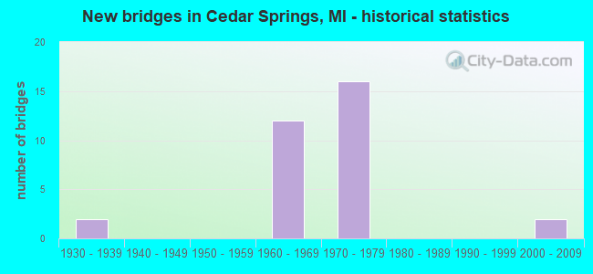
- New bridges - historical statistics
- 21930-1939
- 121960-1969
- 161970-1979
- 22000-2009


- Bridge Condition - Deck
- 9.1%Very good
- 27.3%Good
- 54.5%Satisfactory
- 9.1%Fair

- Bridge Condition - Superstructure
- 27.3%Good
- 36.4%Satisfactory
- 36.4%Fair

- Bridge Condition - Substructure
- 81.8%Good
- 18.2%Satisfactory

- Bridge Condition - Channel
- 33.3%Very good
- 53.3%Good
- 13.3%Satisfactory

- Bridge Condition - Culverts
- 23.1%Very good
- 69.2%Good
- 7.7%Serious
Find on map >> Show street view
Structure Number: 4938, Location: 3.0 MI S OF CEDAR SPRINGS (Lat: 43.175672, Lng: -85.568544), Route carried "on" structure: State highway 57, Year Built: 1969, Status: Open, Structure Length: 4.42m (14.50ft), Average Daily Traffic: 16,071 (year 2007), Truck Traffic: 7%, Average Future Daily Traffic: 19,352 (year 2018), Design Load: HS 20, Features Intersected: WHITE PINE TRAIL(RR ABN)
Minimum Vertical Clearance: 30.48m (100.00ft), Kilometerpoint: 6.721, Lanes on structure: 2, Base Highway Network: Yes (Inventory Route: 41, Subroute: 10), Owner: State Highway Agency, Approaching Roadway Width: 13.4m (44.0ft), Skew: 1 degrees, Material/Design: Steel, Design/Construction: Stringer/Multi-beam, Number Of Spans In Main Unit: 3, Length of Maximum Span: 16.1m (52.8ft), Curb or Sidewalk Widths: Left: 0.2m (0.7ft), Right: 0.2m (0.7ft), Curb-To-Curb Width: 13.4m (44.0ft), Out-to-Out Width: 14.6m (47.9ft)
Condition: Deck: Satisfactory, Superstructure: Good, Substructure: Satisfactory, Operating Rating: 63.5 metric tons, Method Used To Determine Operating Rating: Load Factor (LF), Inventory Rating: 38.1 metric tons, Method Used To Determine Inventory Rating: Load Factor (LF), Structural Evaluation: Equal to present minimum criteria, Deck Geometry: Equal to present minimum criteria, Approach Roadway Alignment: Better than present minimum criteria, Designated Inspection Frequency: Every 24 months, Inspection Date: September 2020, Bridge Improvement Cost: $92,000, Deck Structure Type: Concrete Cast-file-Place, Wearing Surface/Protective System: Wearing Surface: Latex Concrete
Find on map >> Show street view
Structure Number: 4997, Location: @ M-57 (Lat: 43.175631, Lng: -85.575186), Route carried "on" structure: State highway 57, Year Built: 1969, Status: Open, Structure Length: 11.09m (36.38ft), Average Daily Traffic: 16,071 (year 2007), Truck Traffic: 7%, Average Future Daily Traffic: 19,352 (year 2018), Design Load: HS 20, Features Intersected: US-131
Minimum Vertical Clearance: 30.48m (100.00ft), Kilometerpoint: 6.180, Lanes on structure: 2, Lanes under structure: 4, Base Highway Network: Yes (Inventory Route: 41, Subroute: 10), Owner: State Highway Agency, Approaching Roadway Width: 13.4m (44.0ft), Material/Design: Steel, Design/Construction: Stringer/Multi-beam, Number Of Spans In Main Unit: 5, Length of Maximum Span: 30.7m (100.7ft), Curb or Sidewalk Widths: Left: 0.2m (0.7ft), Right: 0.2m (0.7ft), Curb-To-Curb Width: 13.4m (44.0ft), Out-to-Out Width: 14.1m (46.3ft)
Condition: Deck: Satisfactory, Superstructure: Fair, Substructure: Good, Operating Rating: 72.6 metric tons, Method Used To Determine Operating Rating: Load Factor (LF) rating reported by rating factor (RF) method using MS18 loading, Inventory Rating: 43.4 metric tons, Method Used To Determine Inventory Rating: Load Factor (LF) rating reported by rating factor (RF) method using MS18 loading, Structural Evaluation: Somewhat better than minimum adequacy, Deck Geometry: Equal to present minimum criteria, Underclear: Better than present minimum criteria, Approach Roadway Alignment: Equal to present desirable criteria, Designated Inspection Frequency: Every 24 months, Inspection Date: September 2020, Bridge Improvement Cost: $62,000, Deck Structure Type: Concrete Cast-file-Place, Wearing Surface/Protective System: Wearing Surface: Monolithic Concrete
Find on map >> Show street view
Structure Number: 4998, Location: 0.2 MI N OF 16MI RD (Lat: 43.209147, Lng: -85.575014), Route carried "on" structure: US 131, Year Built: 1973, Status: Open, Structure Length: 0.67m (2.20ft), Average Daily Traffic: 36,326 (year 2007), Truck Traffic: 9%, Average Future Daily Traffic: 43,469 (year 2018), Design Load: HS 20+Mod, Features Intersected: CEDAR CR
Minimum Vertical Clearance: 30.48m (100.00ft), Kilometerpoint: 52.330, Lanes on structure: 4, Base Highway Network: Yes (Inventory Route: 41, Subroute: 3), Owner: State Highway Agency, Approaching Roadway Width: 11.0m (36.1ft), Material/Design: Steel, Design/Construction: Culvert, Number Of Spans In Main Unit: 2, Length of Maximum Span: 3.0m (9.8ft), Out-to-Out Width: 100.0m (328.1ft)
Condition: Channel: Satisfactory, Culverts: Serious, Operating Rating: 97.2 metric tons, Method Used To Determine Operating Rating: Load Factor (LF) rating reported by rating factor (RF) method using MS18 loading, Inventory Rating: 97.2 metric tons, Method Used To Determine Inventory Rating: Load Factor (LF) rating reported by rating factor (RF) method using MS18 loading, Structural Evaluation: High priority of corrective action, Waterway Adequacy: Equal to present minimum criteria, Approach Roadway Alignment: Equal to present desirable criteria, Length Of Structure Improvement: 0.67m (2.20ft), Designated Inspection Frequency: Every 12 months, Inspection Date: Febuary 2022, Bridge Improvement Cost: $114,000, Roadway Improvement Cost: $11,000, Total Project Cost: $134,000 ( Estimate for 2050)
Find on map >> Show street view
Structure Number: 4999, Location: 1.0 MI SW OF CEDAR SPRING (Lat: 43.197517, Lng: -85.577817), Route carried "on" structure: County highway , Year Built: 1971, Status: Open, Structure Length: 4.08m (13.39ft), Average Daily Traffic: 668 (year 1996), Truck Traffic: 6%, Average Future Daily Traffic: 1,206 (year 2016), Design Load: HS 20, Features Intersected: US-131 SB, Facility Carried by Structure: INDIAN LAKE RD
Minimum Vertical Clearance: 30.48m (100.00ft), Kilometerpoint: 8.409, Lanes on structure: 2, Lanes under structure: 2, Owner: State Highway Agency, Approaching Roadway Width: 10.9m (35.8ft), Material/Design: Steel, Design/Construction: Stringer/Multi-beam, Number Of Spans In Main Unit: 1, Length of Maximum Span: 40.8m (133.9ft), Curb or Sidewalk Widths: Left: 0.2m (0.7ft), Right: 0.2m (0.7ft), Curb-To-Curb Width: 10.5m (34.4ft), Out-to-Out Width: 11.7m (38.4ft)
Condition: Deck: Very good, Superstructure: Good, Substructure: Good, Operating Rating: 82.3 metric tons, Method Used To Determine Operating Rating: Load Factor (LF) rating reported by rating factor (RF) method using MS18 loading, Inventory Rating: 49.2 metric tons, Method Used To Determine Inventory Rating: Load Factor (LF) rating reported by rating factor (RF) method using MS18 loading, Structural Evaluation: Better than present minimum criteria, Deck Geometry: Equal to present minimum criteria, Underclear: Superior to present desirable criteria, Approach Roadway Alignment: Better than present minimum criteria, Designated Inspection Frequency: Every 24 months, Inspection Date: September 2020, Deck Structure Type: Concrete Cast-file-Place, Wearing Surface/Protective System: Wearing Surface: Monolithic Concrete
Find on map >> Show street view
Structure Number: 5, Location: 1.0 MI SW OF CEDAR SPRING (Lat: 43.197531, Lng: -85.576592), Route carried "on" structure: County highway , Year Built: 1971, Status: Open, Structure Length: 4.08m (13.39ft), Average Daily Traffic: 668 (year 1996), Truck Traffic: 6%, Average Future Daily Traffic: 1,206 (year 2016), Design Load: HS 20, Features Intersected: US-131 NB, Facility Carried by Structure: INDIAN LAKE RD
Minimum Vertical Clearance: 30.48m (100.00ft), Kilometerpoint: 8.509, Lanes on structure: 2, Lanes under structure: 2, Owner: State Highway Agency, Approaching Roadway Width: 10.9m (35.8ft), Material/Design: Steel, Design/Construction: Stringer/Multi-beam, Number Of Spans In Main Unit: 1, Length of Maximum Span: 40.8m (133.9ft), Curb or Sidewalk Widths: Left: 0.2m (0.7ft), Right: 0.2m (0.7ft), Curb-To-Curb Width: 10.5m (34.4ft), Out-to-Out Width: 11.7m (38.4ft)
Condition: Deck: Satisfactory, Superstructure: Good, Substructure: Good, Operating Rating: 79.7 metric tons, Method Used To Determine Operating Rating: Load Factor (LF) rating reported by rating factor (RF) method using MS18 loading, Inventory Rating: 47.6 metric tons, Method Used To Determine Inventory Rating: Load Factor (LF) rating reported by rating factor (RF) method using MS18 loading, Structural Evaluation: Better than present minimum criteria, Deck Geometry: Equal to present minimum criteria, Underclear: Superior to present desirable criteria, Approach Roadway Alignment: Equal to present desirable criteria, Designated Inspection Frequency: Every 24 months, Inspection Date: September 2020, Deck Structure Type: Concrete Cast-file-Place, Wearing Surface/Protective System: Wearing Surface: Monolithic Concrete
Find on map >> Show street view
Structure Number: 5001, Location: 0.5 MI W OF CEDAR SPRINGS (Lat: 43.219817, Lng: -85.574969), Route carried "on" structure: State highway 46, Year Built: 1971, Status: Open, Structure Length: 7.68m (25.20ft), Average Daily Traffic: 16,700 (year 2017), Truck Traffic: 5%, Average Future Daily Traffic: 19,400 (year 2037), Design Load: HS 20, Features Intersected: US-131
Minimum Vertical Clearance: 30.48m (100.00ft), Kilometerpoint: 17.513, Lanes on structure: 2, Lanes under structure: 4, Base Highway Network: Yes (Inventory Route: 44, Subroute: 5), Owner: State Highway Agency, Approaching Roadway Width: 14.3m (46.9ft), Material/Design: Steel, Design/Construction: Stringer/Multi-beam, Number Of Spans In Main Unit: 2, Length of Maximum Span: 38.4m (126.0ft), Curb-To-Curb Width: 14.2m (46.6ft), Out-to-Out Width: 15.4m (50.5ft)
Condition: Deck: Satisfactory, Superstructure: Satisfactory, Substructure: Good, Operating Rating: 69.7 metric tons, Method Used To Determine Operating Rating: Load Factor (LF) rating reported by rating factor (RF) method using MS18 loading, Inventory Rating: 41.8 metric tons, Method Used To Determine Inventory Rating: Load Factor (LF) rating reported by rating factor (RF) method using MS18 loading, Structural Evaluation: Equal to present minimum criteria, Deck Geometry: Superior to present desirable criteria, Underclear: Better than present minimum criteria, Approach Roadway Alignment: Equal to present minimum criteria, Designated Inspection Frequency: Every 24 months, Inspection Date: September 2020, Deck Structure Type: Concrete Cast-file-Place, Wearing Surface/Protective System: Wearing Surface: Epoxy Overlay
Find on map >> Show street view
Structure Number: 5002, Location: 0.5 MI W OF CEDAR SPRINGS (Lat: 43.229814, Lng: -85.571214), Route carried "on" structure: US 131, Year Built: 1971, Status: Open, Structure Length: 5.40m (17.72ft), Average Daily Traffic: 18,575 (year 2017), Truck Traffic: 8%, Average Future Daily Traffic: 20,525 (year 2037), Design Load: HS 20, Features Intersected: WHITE CREEK AVE
Minimum Vertical Clearance: 30.48m (100.00ft), Kilometerpoint: 54.797, Lanes on structure: 2, Lanes under structure: 2, Base Highway Network: Yes (Inventory Route: 41, Subroute: 7), Owner: State Highway Agency, Approaching Roadway Width: 13.7m (44.9ft), Skew: 5 degrees, Material/Design: Steel, Design/Construction: Stringer/Multi-beam, Number Of Spans In Main Unit: 3, Length of Maximum Span: 25.9m (85.0ft), Curb-To-Curb Width: 12.3m (40.4ft), Out-to-Out Width: 13.4m (44.0ft)
Condition: Deck: Good, Superstructure: Fair, Substructure: Good, Operating Rating: 69.7 metric tons, Method Used To Determine Operating Rating: Load Factor (LF) rating reported by rating factor (RF) method using MS18 loading, Inventory Rating: 41.8 metric tons, Method Used To Determine Inventory Rating: Load Factor (LF) rating reported by rating factor (RF) method using MS18 loading, Structural Evaluation: Somewhat better than minimum adequacy, Deck Geometry: Better than present minimum criteria, Underclear: Somewhat better than minimum adequacy, Approach Roadway Alignment: Equal to present desirable criteria, Designated Inspection Frequency: Every 24 months, Inspection Date: September 2021, Bridge Improvement Cost: $102,000, Deck Structure Type: Concrete Cast-file-Place, Wearing Surface/Protective System: Wearing Surface: Latex Concrete
Find on map >> Show street view
Structure Number: 5003, Location: 0.5 MI W OF CEDAR SPRINGS (Lat: 43.228625, Lng: -85.571219), Route carried "on" structure: US 131, Year Built: 1971, Status: Open, Structure Length: 5.69m (18.67ft), Average Daily Traffic: 18,575 (year 2017), Truck Traffic: 8%, Average Future Daily Traffic: 20,525 (year 2037), Design Load: HS 20, Features Intersected: WHITE CREEK AVE
Minimum Vertical Clearance: 30.48m (100.00ft), Kilometerpoint: 54.555, Lanes on structure: 2, Lanes under structure: 2, Base Highway Network: Yes (Inventory Route: 41, Subroute: 3), Owner: State Highway Agency, Approaching Roadway Width: 13.7m (44.9ft), Skew: 5 degrees, Material/Design: Steel, Design/Construction: Stringer/Multi-beam, Number Of Spans In Main Unit: 3, Length of Maximum Span: 27.3m (89.6ft), Curb-To-Curb Width: 12.3m (40.4ft), Out-to-Out Width: 13.4m (44.0ft)
Condition: Deck: Good, Superstructure: Satisfactory, Substructure: Good, Operating Rating: 66.4 metric tons, Method Used To Determine Operating Rating: Load Factor (LF) rating reported by rating factor (RF) method using MS18 loading, Inventory Rating: 39.9 metric tons, Method Used To Determine Inventory Rating: Load Factor (LF) rating reported by rating factor (RF) method using MS18 loading, Structural Evaluation: Equal to present minimum criteria, Deck Geometry: Better than present minimum criteria, Underclear: Somewhat better than minimum adequacy, Approach Roadway Alignment: Equal to present desirable criteria, Designated Inspection Frequency: Every 24 months, Inspection Date: September 2021, Bridge Improvement Cost: $113,000, Deck Structure Type: Concrete Cast-file-Place, Wearing Surface/Protective System: Wearing Surface: Latex Concrete
Find on map >> Show street view
Structure Number: 5004, Location: 1.5 MI N OF CEDAR SPRINGS (Lat: 43.258094, Lng: -85.551408), Route carried "on" structure: US 131, Year Built: 1971, Status: Open, Structure Length: 4.91m (16.11ft), Average Daily Traffic: 15,063 (year 2017), Truck Traffic: 9%, Average Future Daily Traffic: 16,725 (year 2038), Design Load: HS 20, Features Intersected: CEDAR SPRINGS AVE
Minimum Vertical Clearance: 30.48m (100.00ft), Kilometerpoint: 58.424, Lanes on structure: 2, Lanes under structure: 2, Base Highway Network: Yes (Inventory Route: 41, Subroute: 7), Owner: State Highway Agency, Approaching Roadway Width: 12.1m (39.7ft), Skew: 4 degrees, Material/Design: Steel, Design/Construction: Stringer/Multi-beam, Number Of Spans In Main Unit: 3, Length of Maximum Span: 23.1m (75.8ft), Curb-To-Curb Width: 12.3m (40.4ft), Out-to-Out Width: 13.4m (44.0ft)
Condition: Deck: Satisfactory, Superstructure: Fair, Substructure: Good, Operating Rating: 61.6 metric tons, Method Used To Determine Operating Rating: Load Factor (LF) rating reported by rating factor (RF) method using MS18 loading, Inventory Rating: 36.9 metric tons, Method Used To Determine Inventory Rating: Load Factor (LF) rating reported by rating factor (RF) method using MS18 loading, Structural Evaluation: Somewhat better than minimum adequacy, Deck Geometry: Better than present minimum criteria, Underclear: Equal to present minimum criteria, Approach Roadway Alignment: Equal to present desirable criteria, Designated Inspection Frequency: Every 24 months, Inspection Date: August 2021, Deck Structure Type: Concrete Cast-file-Place, Wearing Surface/Protective System: Wearing Surface: Latex Concrete
Find on map >> Show street view
Structure Number: 5005, Location: 1.5 MI N OF CEDAR SPRINGS (Lat: 43.257269, Lng: -85.551408), Route carried "on" structure: US 131, Year Built: 1971, Status: Open, Structure Length: 4.91m (16.11ft), Average Daily Traffic: 15,063 (year 2017), Truck Traffic: 10%, Average Future Daily Traffic: 16,725 (year 2038), Design Load: HS 20, Features Intersected: CEDAR SPRINGS AVE
Minimum Vertical Clearance: 30.48m (100.00ft), Kilometerpoint: 58.230, Lanes on structure: 2, Lanes under structure: 2, Base Highway Network: Yes (Inventory Route: 41, Subroute: 3), Owner: State Highway Agency, Approaching Roadway Width: 12.1m (39.7ft), Skew: 4 degrees, Material/Design: Steel, Design/Construction: Stringer/Multi-beam, Number Of Spans In Main Unit: 3, Length of Maximum Span: 23.1m (75.8ft), Curb-To-Curb Width: 12.3m (40.4ft), Out-to-Out Width: 13.4m (44.0ft)
Condition: Deck: Good, Superstructure: Satisfactory, Substructure: Good, Operating Rating: 59.0 metric tons, Method Used To Determine Operating Rating: Load Factor (LF) rating reported by rating factor (RF) method using MS18 loading, Inventory Rating: 35.3 metric tons, Method Used To Determine Inventory Rating: Load Factor (LF) rating reported by rating factor (RF) method using MS18 loading, Structural Evaluation: Equal to present minimum criteria, Deck Geometry: Better than present minimum criteria, Underclear: Somewhat better than minimum adequacy, Approach Roadway Alignment: Equal to present desirable criteria, Designated Inspection Frequency: Every 24 months, Inspection Date: July 2021, Deck Structure Type: Concrete Cast-file-Place, Wearing Surface/Protective System: Wearing Surface: Latex Concrete, Deck Protection: Epoxy Coated Reinforcing
Find on map >> Show street view
Structure Number: 5056, Location: 0.25 MI N OF 14 MILE RD (Lat: 43.178647, Lng: -85.611269), Route carried "on" structure: County highway 4137, Year Built: 1935, Status: Open, Structure Length: 0.61m (2.00ft), Average Daily Traffic: 3,725 (year 2004), Average Future Daily Traffic: 6,330 (year 2024), Design Load: HS 20+Mod, Features Intersected: CEDAR CREEK, Facility Carried by Structure: ALGOMA AVE
Minimum Vertical Clearance: 30.48m (100.00ft), Kilometerpoint: 6.856, Lanes on structure: 2, Owner: County Highway Agency, Approaching Roadway Width: 9.1m (29.9ft), Material/Design: Steel, Design/Construction: Culvert, Number Of Spans In Main Unit: 1, Length of Maximum Span: 6.1m (20.0ft)
Condition: Channel: Good, Culverts: Good, Operating Rating: 73.2 metric tons, Method Used To Determine Operating Rating: Load Factor (LF) rating reported by rating factor (RF) method using MS18 loading, Inventory Rating: 70.3 metric tons, Method Used To Determine Inventory Rating: Load Factor (LF) rating reported by rating factor (RF) method using MS18 loading, Structural Evaluation: Better than present minimum criteria, Waterway Adequacy: Equal to present desirable criteria, Approach Roadway Alignment: Better than present minimum criteria, Designated Inspection Frequency: Every 24 months, Inspection Date: October 2020
Find on map >> Show street view
Structure Number: 5057, Location: 400 FT NORTH OF 14 MI RD (Lat: 43.176408, Lng: -85.611222), Route carried "on" structure: County highway 4137, Year Built: 1960, Status: Open, Structure Length: 0.88m (2.89ft), Average Daily Traffic: 3,725 (year 2004), Average Future Daily Traffic: 6,330 (year 2024), Design Load: HS 20+Mod, Features Intersected: CEDAR CREEK, Facility Carried by Structure: ALGOMA AVE
Minimum Vertical Clearance: 30.48m (100.00ft), Kilometerpoint: 6.608, Lanes on structure: 2, Owner: County Highway Agency, Approaching Roadway Width: 8.5m (27.9ft), Material/Design: Steel, Design/Construction: Culvert, Number Of Spans In Main Unit: 2, Length of Maximum Span: 3.9m (12.8ft)
Condition: Channel: Good, Culverts: Good, Operating Rating: 39.2 metric tons, Method Used To Determine Operating Rating: Load Factor (LF) rating reported by rating factor (RF) method using MS18 loading, Inventory Rating: 32.4 metric tons, Method Used To Determine Inventory Rating: Load Factor (LF) rating reported by rating factor (RF) method using MS18 loading, Structural Evaluation: Better than present minimum criteria, Waterway Adequacy: Equal to present desirable criteria, Approach Roadway Alignment: Equal to present desirable criteria, Designated Inspection Frequency: Every 24 months, Inspection Date: October 2020
Find on map >> Show street view
Structure Number: 5058, Location: 0.35 MI N OF 14 MILE RD (Lat: 43.180672, Lng: -85.611303), Route carried "on" structure: County highway 4137, Year Built: 1960, Status: Open, Structure Length: 0.88m (2.89ft), Average Daily Traffic: 3,725 (year 2004), Average Future Daily Traffic: 6,330 (year 2024), Design Load: HS 20+Mod, Features Intersected: CEDAR CREEK, Facility Carried by Structure: ALGOMA AVE
Minimum Vertical Clearance: 30.48m (100.00ft), Kilometerpoint: 7.081, Lanes on structure: 2, Owner: County Highway Agency, Approaching Roadway Width: 8.5m (27.9ft), Material/Design: Steel, Design/Construction: Culvert, Number Of Spans In Main Unit: 2, Length of Maximum Span: 3.9m (12.8ft)
Condition: Channel: Very good, Culverts: Very good, Operating Rating: 40.8 metric tons, Method Used To Determine Operating Rating: Load Factor (LF) rating reported by rating factor (RF) method using MS18 loading, Inventory Rating: 34.0 metric tons, Method Used To Determine Inventory Rating: Load Factor (LF) rating reported by rating factor (RF) method using MS18 loading, Structural Evaluation: Equal to present desirable criteria, Waterway Adequacy: Equal to present desirable criteria, Approach Roadway Alignment: Equal to present desirable criteria, Designated Inspection Frequency: Every 24 months, Inspection Date: October 2020
Find on map >> Show street view
Structure Number: 5059, Location: 0.50 MI S OF 15 MILE RD (Lat: 43.182792, Lng: -85.611333), Route carried "on" structure: County highway 4137, Year Built: 2002, Status: Open, Structure Length: 0.98m (3.22ft), Average Daily Traffic: 3,725 (year 2004), Average Future Daily Traffic: 6,330 (year 2024), Design Load: HS 20+Mod, Features Intersected: CEDAR CREEK, Facility Carried by Structure: ALGOMA AVE
Minimum Vertical Clearance: 30.48m (100.00ft), Kilometerpoint: 7.316, Lanes on structure: 2, Owner: County Highway Agency, Approaching Roadway Width: 12.2m (40.0ft), Material/Design: Concrete, Design/Construction: Culvert, Number Of Spans In Main Unit: 12, Length of Maximum Span: 9.8m (32.2ft)
Condition: Channel: Very good, Culverts: Good, Operating Rating: 42.1 metric tons, Method Used To Determine Operating Rating: Load Factor (LF) rating reported by rating factor (RF) method using MS18 loading, Inventory Rating: 32.4 metric tons, Method Used To Determine Inventory Rating: Load Factor (LF) rating reported by rating factor (RF) method using MS18 loading, Structural Evaluation: Better than present minimum criteria, Waterway Adequacy: Equal to present desirable criteria, Approach Roadway Alignment: Equal to present desirable criteria, Designated Inspection Frequency: Every 24 months, Inspection Date: October 2020
Find on map >> Show street view
Structure Number: 506, Location: 300 FT S OF 15 MILE RD (Lat: 43.189053, Lng: -85.611389), Route carried "on" structure: County highway 4137, Year Built: 1960, Status: Open, Structure Length: 0.79m (2.59ft), Average Daily Traffic: 3,725 (year 2004), Average Future Daily Traffic: 6,330 (year 2024), Design Load: HS 20+Mod, Features Intersected: CEDAR CREEK, Facility Carried by Structure: ALGOMA AVE
Minimum Vertical Clearance: 30.48m (100.00ft), Kilometerpoint: 8.012, Lanes on structure: 2, Owner: County Highway Agency, Approaching Roadway Width: 8.5m (27.9ft), Material/Design: Steel, Design/Construction: Culvert, Number Of Spans In Main Unit: 2, Length of Maximum Span: 3.6m (11.8ft)
Condition: Channel: Good, Culverts: Good, Operating Rating: 46.3 metric tons, Method Used To Determine Operating Rating: Load Factor (LF) rating reported by rating factor (RF) method using MS18 loading, Inventory Rating: 39.5 metric tons, Method Used To Determine Inventory Rating: Load Factor (LF) rating reported by rating factor (RF) method using MS18 loading, Structural Evaluation: Better than present minimum criteria, Waterway Adequacy: Equal to present desirable criteria, Approach Roadway Alignment: Equal to present desirable criteria, Designated Inspection Frequency: Every 24 months, Inspection Date: October 2020
Find on map >> Show street view
Structure Number: 5061, Location: 0.06 MI N OF SOLON ST (Lat: 43.227992, Lng: -85.610939), Route carried "on" structure: County highway 4137, Year Built: 2002, Status: Open, Structure Length: 0.76m (2.49ft), Average Daily Traffic: 4,835 (year 2004), Average Future Daily Traffic: 8,220 (year 2024), Design Load: HS 20+Mod, Features Intersected: DUKE CREEK, Facility Carried by Structure: ALGOMA AVE
Minimum Vertical Clearance: 30.48m (100.00ft), Kilometerpoint: 12.344, Lanes on structure: 2, Owner: County Highway Agency, Approaching Roadway Width: 12.2m (40.0ft), Material/Design: Concrete, Design/Construction: Culvert, Number Of Spans In Main Unit: 1, Length of Maximum Span: 7.6m (24.9ft)
Condition: Channel: Very good, Culverts: Very good, Operating Rating: 49.9 metric tons, Method Used To Determine Operating Rating: Load Factor (LF) rating reported by rating factor (RF) method using MS18 loading, Inventory Rating: 38.6 metric tons, Method Used To Determine Inventory Rating: Load Factor (LF) rating reported by rating factor (RF) method using MS18 loading, Structural Evaluation: Equal to present desirable criteria, Waterway Adequacy: Equal to present desirable criteria, Approach Roadway Alignment: Equal to present desirable criteria, Designated Inspection Frequency: Every 24 months, Inspection Date: October 2020, Deck Structure Type: Concrete Cast-file-Place, Wearing Surface/Protective System: Wearing Surface: Bituminous
Find on map >> Show street view
Structure Number: 509, Location: 0.4 MI E OF WHITE CREEK (Lat: 43.219942, Lng: -85.562789), Route carried "on" structure: County highway 4188, Year Built: 1978, Status: Open, Structure Length: 0.91m (2.99ft), Average Daily Traffic: 23,046 (year 2005), Average Future Daily Traffic: 39,180 (year 2025), Design Load: HS 20+Mod, Features Intersected: CEDAR CREEK, Facility Carried by Structure: 17 MILE ROAD
Minimum Vertical Clearance: 30.48m (100.00ft), Kilometerpoint: 18.500, Lanes on structure: 4, Owner: County Highway Agency, Approaching Roadway Width: 15.9m (52.2ft), Material/Design: Prestressed concrete, Design/Construction: Box Beam or Girders - Multiple, Number Of Spans In Main Unit: 1, Length of Maximum Span: 9.1m (29.9ft), Curb or Sidewalk Widths: Left: 1.5m (4.9ft), Right: 1.5m (4.9ft), Curb-To-Curb Width: 15.9m (52.2ft), Out-to-Out Width: 19.6m (64.3ft)
Condition: Deck: Satisfactory, Superstructure: Satisfactory, Substructure: Good, Channel: Very good, Operating Rating: 46.2 metric tons, Method Used To Determine Operating Rating: Load Factor (LF), Inventory Rating: 27.7 metric tons, Method Used To Determine Inventory Rating: Load Factor (LF), Structural Evaluation: Equal to present minimum criteria, Deck Geometry: Meets minimum limits, Waterway Adequacy: Equal to present desirable criteria, Approach Roadway Alignment: Equal to present desirable criteria, Designated Inspection Frequency: Every 24 months, Inspection Date: October 2020, Deck Structure Type: Concrete Cast-file-Place, Wearing Surface/Protective System: Wearing Surface: Bituminous, Membrane: Preformed Fabric
Find on map >> Show street view
Structure Number: 5103, Location: 0.30 MI W OF ALGOMA AVE (Lat: 43.175339, Lng: -85.617244), Route carried "on" structure: County highway , Year Built: 1969, Status: Open, Structure Length: 0.88m (2.89ft), Average Daily Traffic: 942 (year 2004), Average Future Daily Traffic: 1,600 (year 2024), Design Load: HS 20+Mod, Features Intersected: CEDAR CREEK, Facility Carried by Structure: 14 MILE RD
Minimum Vertical Clearance: 30.48m (100.00ft), Kilometerpoint: 2.762, Lanes on structure: 2, Owner: County Highway Agency, Approaching Roadway Width: 10.4m (34.1ft), Material/Design: Steel, Design/Construction: Culvert, Number Of Spans In Main Unit: 2, Length of Maximum Span: 4.2m (13.8ft)
Condition: Channel: Very good, Culverts: Very good, Operating Rating: 79.7 metric tons, Method Used To Determine Operating Rating: Load Factor (LF) rating reported by rating factor (RF) method using MS18 loading, Inventory Rating: 78.7 metric tons, Method Used To Determine Inventory Rating: Load Factor (LF) rating reported by rating factor (RF) method using MS18 loading, Structural Evaluation: Equal to present desirable criteria, Waterway Adequacy: Equal to present desirable criteria, Approach Roadway Alignment: Equal to present desirable criteria, Designated Inspection Frequency: Every 24 months, Inspection Date: October 2020
Find on map >> Show street view
Structure Number: 5104, Location: 0.1 MI E OF ALGOMA AVE (Lat: 43.189950, Lng: -85.609414), Route carried "on" structure: County highway , Year Built: 1965, Status: Open, Structure Length: 0.70m (2.30ft), Average Daily Traffic: 104 (year 2003), Average Future Daily Traffic: 180 (year 2023), Design Load: HS 20+Mod, Features Intersected: CEDAR CREEK, Facility Carried by Structure: 15 MILE ROAD
Minimum Vertical Clearance: 30.48m (100.00ft), Kilometerpoint: 1.780, Lanes on structure: 2, Owner: County Highway Agency, Approaching Roadway Width: 8.5m (27.9ft), Material/Design: Steel, Design/Construction: Culvert, Number Of Spans In Main Unit: 2, Length of Maximum Span: 3.9m (12.8ft)
Condition: Channel: Good, Culverts: Good, Operating Rating: 41.8 metric tons, Method Used To Determine Operating Rating: Load Factor (LF) rating reported by rating factor (RF) method using MS18 loading, Inventory Rating: 34.7 metric tons, Method Used To Determine Inventory Rating: Load Factor (LF) rating reported by rating factor (RF) method using MS18 loading, Structural Evaluation: Better than present minimum criteria, Waterway Adequacy: Equal to present desirable criteria, Approach Roadway Alignment: Equal to present desirable criteria, Designated Inspection Frequency: Every 24 months, Inspection Date: October 2020
Find on map >> Show street view
Structure Number: 5105, Location: 0.50 MI E OF ALGOMA RD (Lat: 43.197333, Lng: -85.601108), Route carried "on" structure: County highway , Year Built: 1962, Status: Open, Structure Length: 0.76m (2.49ft), Average Daily Traffic: 741 (year 2003), Average Future Daily Traffic: 1,260 (year 2023), Design Load: HS 20+Mod, Features Intersected: CEDAR CREEK, Facility Carried by Structure: INDIAN LAKES RD
Minimum Vertical Clearance: 30.48m (100.00ft), Kilometerpoint: 6.516, Lanes on structure: 2, Owner: County Highway Agency, Approaching Roadway Width: 6.7m (22.0ft), Skew: 1 degrees, Material/Design: Steel, Design/Construction: Culvert, Number Of Spans In Main Unit: 2, Length of Maximum Span: 3.6m (11.8ft)
Condition: Channel: Good, Culverts: Good, Operating Rating: 41.1 metric tons, Method Used To Determine Operating Rating: Load Factor (LF) rating reported by rating factor (RF) method using MS18 loading, Inventory Rating: 34.0 metric tons, Method Used To Determine Inventory Rating: Load Factor (LF) rating reported by rating factor (RF) method using MS18 loading, Structural Evaluation: Better than present minimum criteria, Waterway Adequacy: Equal to present desirable criteria, Approach Roadway Alignment: Somewhat better than minimum adequacy, Designated Inspection Frequency: Every 24 months, Inspection Date: October 2020
Find on map >> Show street view
Structure Number: 5156, Location: 0.50 MI W OF WHITE CREEK (Lat: 43.205319, Lng: -85.581456), Route carried "on" structure: County highway , Year Built: 1965, Status: Open, Structure Length: 0.76m (2.49ft), Average Daily Traffic: 343 (year 2005), Average Future Daily Traffic: 580 (year 2025), Design Load: HS 20+Mod, Features Intersected: CEDAR CREEK, Facility Carried by Structure: 16 MILE ROAD
Minimum Vertical Clearance: 30.48m (100.00ft), Kilometerpoint: 4.083, Lanes on structure: 2, Owner: County Highway Agency, Approaching Roadway Width: 9.8m (32.2ft), Material/Design: Steel, Design/Construction: Culvert, Number Of Spans In Main Unit: 2, Length of Maximum Span: 3.6m (11.8ft)
Condition: Channel: Good, Culverts: Good, Operating Rating: 41.1 metric tons, Method Used To Determine Operating Rating: Load Factor (LF) rating reported by rating factor (RF) method using MS18 loading, Inventory Rating: 34.0 metric tons, Method Used To Determine Inventory Rating: Load Factor (LF) rating reported by rating factor (RF) method using MS18 loading, Structural Evaluation: Better than present minimum criteria, Waterway Adequacy: Equal to present desirable criteria, Approach Roadway Alignment: Equal to present desirable criteria, Designated Inspection Frequency: Every 24 months, Inspection Date: November 2021
Find on map >> Show street view
Structure Number: 516, Location: 0.40 MI E OF SIMMONS AVE (Lat: 43.234256, Lng: -85.583128), Route carried "on" structure: County highway , Year Built: 1968, Status: Open, Structure Length: 1.00m (3.28ft), Average Daily Traffic: 2,318 (year 2005), Average Future Daily Traffic: 3,940 (year 2025), Design Load: HS 20+Mod, Features Intersected: DUKE CREEK, Facility Carried by Structure: 18 MILE ROAD
Minimum Vertical Clearance: 30.48m (100.00ft), Kilometerpoint: 4.682, Lanes on structure: 2, Owner: County Highway Agency, Approaching Roadway Width: 9.1m (29.9ft), Material/Design: Steel, Design/Construction: Culvert, Number Of Spans In Main Unit: 3, Length of Maximum Span: 3.6m (11.8ft)
Condition: Channel: Good, Culverts: Good, Operating Rating: 53.8 metric tons, Method Used To Determine Operating Rating: Load Factor (LF) rating reported by rating factor (RF) method using MS18 loading, Inventory Rating: 47.6 metric tons, Method Used To Determine Inventory Rating: Load Factor (LF) rating reported by rating factor (RF) method using MS18 loading, Structural Evaluation: Better than present minimum criteria, Waterway Adequacy: Equal to present minimum criteria, Approach Roadway Alignment: Equal to present desirable criteria, Designated Inspection Frequency: Every 24 months, Inspection Date: October 2020
Find on map >> Show street view
Structure Number: 5161, Location: .30 MI W OF CEDAR SPRINGS (Lat: 43.256525, Lng: -85.558600), Route carried "on" structure: County highway , Year Built: 1962, Status: Open, Structure Length: 0.61m (2.00ft), Average Daily Traffic: 282 (year 2005), Average Future Daily Traffic: 480 (year 2025), Design Load: HS 20+Mod, Features Intersected: DUKE CREEK, Facility Carried by Structure: EGNER STREET
Minimum Vertical Clearance: 30.48m (100.00ft), Kilometerpoint: 3.014, Lanes on structure: 2, Owner: County Highway Agency, Approaching Roadway Width: 8.5m (27.9ft), Material/Design: Steel, Design/Construction: Culvert, Number Of Spans In Main Unit: 2, Length of Maximum Span: 2.7m (8.9ft)
Condition: Channel: Good, Culverts: Good, Operating Rating: 90.7 metric tons, Method Used To Determine Operating Rating: Load Factor (LF) rating reported by rating factor (RF) method using MS18 loading, Inventory Rating: 87.5 metric tons, Method Used To Determine Inventory Rating: Load Factor (LF) rating reported by rating factor (RF) method using MS18 loading, Structural Evaluation: Better than present minimum criteria, Waterway Adequacy: Equal to present desirable criteria, Approach Roadway Alignment: Equal to present desirable criteria, Designated Inspection Frequency: Every 24 months, Inspection Date: October 2020
Find on map >> Show street view
Structure Number: 5185, Location: 30 FT N OF OAK STREET (Lat: 43.226347, Lng: -85.551194), Route carried "on" structure: City street , Year Built: 1935, Status: Posted for load, Structure Length: 0.76m (2.49ft), Average Daily Traffic: 10,560 (year 1999), Truck Traffic: 5%, Average Future Daily Traffic: 15,700 (year 2026), Features Intersected: CEDAR CREEK, Facility Carried by Structure: MAIN STREET
Minimum Vertical Clearance: 30.48m (100.00ft), Kilometerpoint: 23.496, Lanes on structure: 4, Owner: City or Municipal Highway Agency, Approaching Roadway Width: 13.4m (44.0ft), Skew: 6 degrees, Material/Design: Concrete continuous, Design/Construction: Slab, Number Of Spans In Main Unit: 2, Length of Maximum Span: 3.7m (12.1ft), Curb or Sidewalk Widths: Left: 4.4m (14.4ft), Right: 3.8m (12.5ft), Curb-To-Curb Width: 13.4m (44.0ft), Out-to-Out Width: 21.6m (70.9ft)
Condition: Deck: Fair, Superstructure: Fair, Substructure: Satisfactory, Channel: Satisfactory, Operating Rating: 16.8 metric tons, Method Used To Determine Operating Rating: Load Factor (LF) rating reported by rating factor (RF) method using MS18 loading, Inventory Rating: 10.0 metric tons, Method Used To Determine Inventory Rating: Load Factor (LF) rating reported by rating factor (RF) method using MS18 loading, Structural Evaluation: High priority of replacement, Deck Geometry: High priority of replacement, Waterway Adequacy: Equal to present minimum criteria, Approach Roadway Alignment: Equal to present desirable criteria, Bridge Posting: Required (Relationship of Operating Rating to Maximum Legal Load: 0.1 - 9.9% below), Length Of Structure Improvement: 2.50m (8.20ft), Designated Inspection Frequency: Every 24 months, Inspection Date: April 2020, Bridge Improvement Cost: $880,000, Roadway Improvement Cost: $250,000, Total Project Cost: $1,130,000 ( Estimate for 2017), Deck Structure Type: Concrete Cast-file-Place, Wearing Surface/Protective System: Wearing Surface: Bituminous
Find on map >> Show street view
Structure Number: 4997, Location: @ M-57 (Lat: 43.175631, Lng: -85.575186), Route carried "under" structure: US 131, Year Built: 1969, Structure Length: 0. m, Average Daily Traffic: 36,326 (year 2007), Truck Traffic: 9%, Features Intersected: US-131, Facility Carried by Structure: 14 MI RD (M-57)
Minimum Vertical Clearance: 4.98m (16.34ft), Kilometerpoint: 48.596, Lanes on structure: 2, Lanes under structure: 4, Material/Design: Steel, Design/Construction: Stringer/Multi-beam, Length of Maximum Span: 30.7m (100.7ft)
Find on map >> Show street view
Structure Number: 4999, Location: 1.0 MI SW OF CEDAR SPRING (Lat: 43.197517, Lng: -85.577817), Route carried "under" structure: US 131, Year Built: 1971, Structure Length: 0. m, Average Daily Traffic: 18,163 (year 2007), Truck Traffic: 9%, Features Intersected: US-131 SB, Facility Carried by Structure: INDIAN LAKE RD
Minimum Vertical Clearance: 5.11m (16.77ft), Kilometerpoint: 51.119, Lanes on structure: 2, Lanes under structure: 2, Material/Design: Steel, Design/Construction: Stringer/Multi-beam, Length of Maximum Span: 40.8m (133.9ft)
Find on map >> Show street view
Structure Number: 5, Location: 1.0 MI SW OF CEDAR SPRING (Lat: 43.197531, Lng: -85.576592), Route carried "under" structure: US 131, Year Built: 1971, Structure Length: 0. m, Average Daily Traffic: 18,163 (year 2007), Truck Traffic: 9%, Features Intersected: US-131 NB, Facility Carried by Structure: INDIAN LAKE RD
Minimum Vertical Clearance: 5.08m (16.67ft), Kilometerpoint: 51.032, Lanes on structure: 2, Lanes under structure: 2, Material/Design: Steel, Design/Construction: Stringer/Multi-beam, Length of Maximum Span: 40.8m (133.9ft)
Find on map >> Show street view
Structure Number: 5001, Location: 0.5 MI W OF CEDAR SPRINGS (Lat: 43.219817, Lng: -85.574969), Route carried "under" structure: US 131, Year Built: 1971, Structure Length: 0. m, Average Daily Traffic: 37,150 (year 2017), Truck Traffic: 8%, Features Intersected: US-131, Facility Carried by Structure: M-46
Minimum Vertical Clearance: 5.18m (16.99ft), Kilometerpoint: 53.514, Lanes on structure: 2, Lanes under structure: 4, Material/Design: Steel, Design/Construction: Stringer/Multi-beam, Length of Maximum Span: 38.4m (126.0ft)
Find on map >> Show street view
Structure Number: 5002, Location: 0.5 MI W OF CEDAR SPRINGS (Lat: 43.229814, Lng: -85.571214), Route carried "under" structure: County highway , Year Built: 1971, Structure Length: 0. m, Average Daily Traffic: 3,391 (year 1997), Truck Traffic: 6%, Features Intersected: WHITE CREEK AVE, Facility Carried by Structure: US-131 SB
Minimum Vertical Clearance: 4.47m (14.67ft), Kilometerpoint: 6.016, Lanes on structure: 2, Lanes under structure: 2, Material/Design: Steel, Design/Construction: Stringer/Multi-beam, Length of Maximum Span: 25.9m (85.0ft)
Find on map >> Show street view
Structure Number: 5003, Location: 0.5 MI W OF CEDAR SPRINGS (Lat: 43.228625, Lng: -85.571219), Route carried "under" structure: County highway , Year Built: 1971, Structure Length: 0. m, Average Daily Traffic: 3,391 (year 1997), Truck Traffic: 6%, Features Intersected: WHITE CREEK AVE, Facility Carried by Structure: US-131 NB
Minimum Vertical Clearance: 4.37m (14.34ft), Kilometerpoint: 5.884, Lanes on structure: 2, Lanes under structure: 2, Material/Design: Steel, Design/Construction: Stringer/Multi-beam, Length of Maximum Span: 27.3m (89.6ft)
Find on map >> Show street view
Structure Number: 5004, Location: 1.5 MI N OF CEDAR SPRINGS (Lat: 43.258094, Lng: -85.551408), Route carried "under" structure: County highway , Year Built: 1971, Structure Length: 0. m, Average Daily Traffic: 1,575 (year 2017), Truck Traffic: 6%, Features Intersected: CEDAR SPRINGS AVE, Facility Carried by Structure: US-131SB & M-46WB
Minimum Vertical Clearance: 4.44m (14.57ft), Kilometerpoint: 2.871, Lanes on structure: 2, Lanes under structure: 2, Material/Design: Steel, Design/Construction: Stringer/Multi-beam, Length of Maximum Span: 23.1m (75.8ft)
Find on map >> Show street view
Structure Number: 5005, Location: 1.5 MI N OF CEDAR SPRINGS (Lat: 43.257269, Lng: -85.551408), Route carried "under" structure: County highway , Year Built: 1971, Structure Length: 0. m, Average Daily Traffic: 1,575 (year 2017), Truck Traffic: 6%, Features Intersected: CEDAR SPRINGS AVE, Facility Carried by Structure: US-131NB & M-46EB
Minimum Vertical Clearance: 4.34m (14.24ft), Kilometerpoint: 2.779, Lanes on structure: 2, Lanes under structure: 2, Material/Design: Steel, Design/Construction: Stringer/Multi-beam, Length of Maximum Span: 23.1m (75.8ft)