Bridge Statistics for Catlin, Illinois (IL)
Condition, Traffic, Stress, Structural Evaluation, Project Costs
- National Bridge Inventory (NBI) Statistics
- 14Number of bridges
- 112ft / 34.1mTotal length
- 77,875Total average daily traffic
- 25,021Total average daily truck traffic
- National Bridge Inventory (NBI) Registered Bridges for Catlin
- No street view available for this location
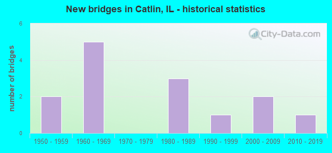
- New bridges - historical statistics
- 21950-1959
- 51960-1969
- 31980-1989
- 11990-1999
- 22000-2009
- 12010-2019


- Bridge Condition - Deck
- 28.6%Very good
- 28.6%Good
- 14.3%Satisfactory
- 28.6%Poor

- Bridge Condition - Superstructure
- 42.9%Very good
- 14.3%Satisfactory
- 14.3%Fair
- 28.6%Poor

- Bridge Condition - Substructure
- 42.9%Very good
- 42.9%Good
- 14.3%Poor

- Bridge Condition - Channel
- 11.1%Excellent
- 22.2%Very good
- 11.1%Good
- 33.3%Satisfactory
- 22.2%Fair

- Bridge Condition - Culverts
- 25.0%Good
- 25.0%Satisfactory
- 50.0%Fair
Find on map >> Show street view
Structure Number: 920051, Location: W OF DANVILLE (Lat: 40.123400, Lng: -87.711725), Route carried "on" structure: US 150, Year Built: 1960, Status: Open, Structure Length: 6.84m (22.44ft), Average Daily Traffic: 4,400 (year 2021), Truck Traffic: 7%, Average Future Daily Traffic: 4,673 (year 2032), Design Load: HS 20, Features Intersected: I-74
Minimum Vertical Clearance: 30+ m (98+ ft), Kilometerpoint: 346.466, Lanes on structure: 3, Lanes under structure: 4, Base Highway Network: Yes, Owner: State Highway Agency, Approaching Roadway Width: 15.2m (49.9ft), Skew: 33 degrees, Material/Design: Prestressed concrete, Design/Construction: Stringer/Multi-beam, Number Of Spans In Main Unit: 4, Length of Maximum Span: 20.3m (66.6ft), Curb-To-Curb Width: 13.4m (44.0ft), Out-to-Out Width: 17.2m (56.4ft)
Condition: Deck: Poor, Superstructure: Poor, Substructure: Poor, Operating Rating: 40.2 metric tons, Method Used To Determine Operating Rating: Load Factor (LF) rating reported by rating factor (RF) method using MS18 loading, Inventory Rating: 24.0 metric tons, Method Used To Determine Inventory Rating: Load Factor (LF) rating reported by rating factor (RF) method using MS18 loading, Structural Evaluation: Meets minimum limits, Deck Geometry: Somewhat better than minimum adequacy, Underclear: Meets minimum limits, Approach Roadway Alignment: Better than present minimum criteria, Designated Inspection Frequency: Every 12 months, Inspection Date: April 2021, Deck Structure Type: Concrete Cast-file-Place, Wearing Surface/Protective System: Wearing Surface: Bituminous
Find on map >> Show street view
Structure Number: 920099, Location: W OF DANVILLE (Lat: 40.119536, Lng: -87.702294), Route carried "on" structure: Other road , Year Built: 1962, Status: Open, Structure Length: 7.49m (24.57ft), Average Daily Traffic: 1,050 (year 2019), Truck Traffic: 5%, Average Future Daily Traffic: 1,386 (year 2032), Design Load: HS 15, Features Intersected: FAI 74, Facility Carried by Structure: Batestown (FAU 700
Minimum Vertical Clearance: 30+ m (98+ ft), Kilometerpoint: 1.706, Lanes on structure: 2, Lanes under structure: 4, Owner: State Highway Agency, Approaching Roadway Width: 7.3m (24.0ft), Skew: 3 degrees, Material/Design: Concrete continuous, Design/Construction: Tee Beam, Number Of Spans In Main Unit: 4, Length of Maximum Span: 20.6m (67.6ft), Curb-To-Curb Width: 7.9m (25.9ft), Out-to-Out Width: 9.8m (32.2ft)
Condition: Deck: Poor, Superstructure: Poor, Substructure: Good, Operating Rating: 46.3 metric tons, Method Used To Determine Operating Rating: Load Factor (LF) rating reported by rating factor (RF) method using MS18 loading, Inventory Rating: 27.9 metric tons, Method Used To Determine Inventory Rating: Load Factor (LF) rating reported by rating factor (RF) method using MS18 loading, Structural Evaluation: Meets minimum limits, Deck Geometry: Meets minimum limits, Underclear: Meets minimum limits, Approach Roadway Alignment: Better than present minimum criteria, Designated Inspection Frequency: Every 12 months, Inspection Date: April 2021, Deck Structure Type: Concrete Cast-file-Place, Wearing Surface/Protective System: Wearing Surface: Bituminous
Find on map >> Show street view
Structure Number: 920138, Location: W EDGE OF CATLIN (Lat: 40.065153, Lng: -87.717439), Route carried "on" structure: Other road , Year Built: 1952, Status: Open, Structure Length: 0.97m (3.18ft), Average Daily Traffic: 2,950 (year 2019), Truck Traffic: 12%, Average Future Daily Traffic: 3,081 (year 2032), Design Load: HS 20, Features Intersected: BUTLER CREEK, Facility Carried by Structure: FAS 512(CH8)
Minimum Vertical Clearance: 30+ m (98+ ft), Kilometerpoint: 0.612, Lanes on structure: 2, Owner: County Highway Agency, Approaching Roadway Width: 10.4m (34.1ft), Skew: 4 degrees, Material/Design: Concrete, Design/Construction: Culvert, Number Of Spans In Main Unit: 2, Length of Maximum Span: 4.7m (15.4ft)
Condition: Channel: Satisfactory, Culverts: Satisfactory, Operating Rating: 44.1 metric tons, Method Used To Determine Operating Rating: Allowable Stress (AS) rating reported by rating factor (RF) method using MS18 loading, Inventory Rating: 32.4 metric tons, Method Used To Determine Inventory Rating: Allowable Stress (AS) rating reported by rating factor (RF) method using MS18 loading, Structural Evaluation: Equal to present minimum criteria, Waterway Adequacy: Equal to present desirable criteria, Approach Roadway Alignment: Equal to present desirable criteria, Designated Inspection Frequency: Every 24 months, Inspection Date: Febuary 2021
Find on map >> Show street view
Structure Number: 922005, Location: 3.5 MI E OF OAKWOOD (Lat: 40.119047, Lng: -87.721617), Route carried "on" structure: US 150, Year Built: 1953, Status: Open, Structure Length: 0.88m (2.89ft), Average Future Daily Traffic: 3,646 (year 2032), Design Load: HS 20, Features Intersected: STREAM
Minimum Vertical Clearance: 30+ m (98+ ft), Kilometerpoint: 345.404, Lanes on structure: 2, Base Highway Network: Yes, Owner: State Highway Agency, Approaching Roadway Width: 9.1m (29.9ft), Skew: 2 degrees, Material/Design: Concrete continuous, Design/Construction: Culvert, Number Of Spans In Main Unit: 2, Length of Maximum Span: 4.3m (14.1ft)
Condition: Channel: Satisfactory, Culverts: Fair, Operating Rating: 89.1 metric tons, Method Used To Determine Operating Rating: Field evaluation and documented engineering judgment, Inventory Rating: 89.1 metric tons, Method Used To Determine Inventory Rating: Field evaluation and documented engineering judgment, Structural Evaluation: Somewhat better than minimum adequacy, Waterway Adequacy: Equal to present desirable criteria, Approach Roadway Alignment: Equal to present desirable criteria, Designated Inspection Frequency: Every 24 months, Inspection Date: June 2021
Find on map >> Show street view
Structure Number: 923326, Location: 2.5 MI N CATLIN (Lat: 40.102056, Lng: -87.714678), Route carried "on" structure: Other road , Year Built: 1982, Status: Open, Structure Length: 9.29m (30.48ft), Average Daily Traffic: 750 (year 2019), Truck Traffic: 9%, Average Future Daily Traffic: 719 (year 2032), Design Load: HS 20, Features Intersected: VERMILION RIVER, Facility Carried by Structure: FAS 507(TR 210)
Minimum Vertical Clearance: 30+ m (98+ ft), Kilometerpoint: 2.044, Lanes on structure: 2, Owner: Town or Township Highway Agency, Approaching Roadway Width: 10.4m (34.1ft), Material/Design: Steel continuous, Design/Construction: Stringer/Multi-beam, Number Of Spans In Main Unit: 2, Length of Maximum Span: 45.7m (149.9ft), Curb-To-Curb Width: 8.5m (27.9ft), Out-to-Out Width: 8.7m (28.5ft)
Condition: Deck: Good, Superstructure: Fair, Substructure: Good, Channel: Fair, Operating Rating: 53.8 metric tons, Method Used To Determine Operating Rating: Load Factor (LF) rating reported by rating factor (RF) method using MS18 loading, Inventory Rating: 32.4 metric tons, Method Used To Determine Inventory Rating: Load Factor (LF) rating reported by rating factor (RF) method using MS18 loading, Structural Evaluation: Somewhat better than minimum adequacy, Deck Geometry: Somewhat better than minimum adequacy, Waterway Adequacy: Better than present minimum criteria, Approach Roadway Alignment: Meets minimum limits, Designated Inspection Frequency: Every 24 months, Inspection Date: Febuary 2022, Deck Structure Type: Concrete Cast-file-Place, Wearing Surface/Protective System: Wearing Surface: Gravel
Find on map >> Show street view
Structure Number: 923373, Location: 2.6 MI N OF CATLIN (Lat: 40.101981, Lng: -87.715953), Route carried "on" structure: County highway , Year Built: 1988, Status: Open, Structure Length: 2.19m (7.19ft), Average Daily Traffic: 150 (year 2019), Average Future Daily Traffic: 163 (year 2032), Design Load: HS 20, Features Intersected: BUTLER BRANCH, Facility Carried by Structure: TR 297
Minimum Vertical Clearance: 30+ m (98+ ft), Kilometerpoint: 1.931, Lanes on structure: 2, Owner: Town or Township Highway Agency, Approaching Roadway Width: 7.3m (24.0ft), Skew: 1 degrees, Material/Design: Prestressed concrete, Design/Construction: Box Beam or Girders - Multiple, Number Of Spans In Main Unit: 1, Length of Maximum Span: 20.7m (67.9ft), Curb-To-Curb Width: 8.2m (26.9ft), Out-to-Out Width: 8.2m (26.9ft)
Condition: Deck: Satisfactory, Superstructure: Satisfactory, Substructure: Good, Channel: Good, Operating Rating: 44.4 metric tons, Method Used To Determine Operating Rating: Assigned rating based on Load Factor Design (LFD) reported by rating factor (RF) using MS18 loading, Inventory Rating: 32.4 metric tons, Method Used To Determine Inventory Rating: Assigned rating based on Load Factor Design (LFD) reported by rating factor (RF) using MS18 loading, Structural Evaluation: Equal to present minimum criteria, Deck Geometry: Somewhat better than minimum adequacy, Waterway Adequacy: Somewhat better than minimum adequacy, Approach Roadway Alignment: Equal to present minimum criteria, Designated Inspection Frequency: Every 24 months, Inspection Date: Febuary 2021, Deck Structure Type: Concrete Precast Panels, Wearing Surface/Protective System: Wearing Surface: Gravel
Find on map >> Show street view
Structure Number: 923421, Location: 0.5 MI NW OF CATLIN (Lat: 40.078728, Lng: -87.713750), Route carried "on" structure: County highway , Year Built: 1993, Status: Open, Structure Length: 0.79m (2.59ft), Average Daily Traffic: 50 (year 2019), Truck Traffic: 4%, Average Future Daily Traffic: 61 (year 2032), Design Load: HS 20, Features Intersected: BUTLER BRANCH, Facility Carried by Structure: TR 216
Minimum Vertical Clearance: 30+ m (98+ ft), Kilometerpoint: 0.402, Lanes on structure: 2, Owner: Town or Township Highway Agency, Approaching Roadway Width: 5.5m (18.0ft), Material/Design: Concrete, Design/Construction: Culvert, Number Of Spans In Main Unit: 2, Length of Maximum Span: 3.7m (12.1ft)
Condition: Channel: Fair, Culverts: Fair, Operating Rating: 44.1 metric tons, Method Used To Determine Operating Rating: Assigned rating based on Load Factor Design (LFD) reported by rating factor (RF) using MS18 loading, Inventory Rating: 32.4 metric tons, Method Used To Determine Inventory Rating: Assigned rating based on Load Factor Design (LFD) reported by rating factor (RF) using MS18 loading, Structural Evaluation: Somewhat better than minimum adequacy, Waterway Adequacy: Equal to present desirable criteria, Approach Roadway Alignment: Equal to present minimum criteria, Designated Inspection Frequency: Every 24 months, Inspection Date: Febuary 2022
Find on map >> Show street view
Structure Number: 923505, Location: 4 MI S CATLIN (Lat: 40.009561, Lng: -87.720089), Route carried "on" structure: County highway , Year Built: 2006, Status: Open, Structure Length: 1.41m (4.63ft), Average Daily Traffic: 100 (year 2019), Truck Traffic: 20%, Average Future Daily Traffic: 77 (year 2032), Design Load: HS 20, Features Intersected: FAYETTE CREEK, Facility Carried by Structure: TR 373
Minimum Vertical Clearance: 30+ m (98+ ft), Kilometerpoint: 5.665, Lanes on structure: 1, Owner: Town or Township Highway Agency, Approaching Roadway Width: 7.9m (25.9ft), Skew: 2 degrees, Material/Design: Steel continuous, Design/Construction: Stringer/Multi-beam, Number Of Spans In Main Unit: 1, Length of Maximum Span: 13.3m (43.6ft), Curb-To-Curb Width: 8.2m (26.9ft), Out-to-Out Width: 8.2m (26.9ft)
Condition: Deck: Good, Superstructure: Very good, Substructure: Very good, Channel: Very good, Operating Rating: 44.1 metric tons, Method Used To Determine Operating Rating: Assigned rating based on Load Factor Design (LFD) reported by rating factor (RF) using MS18 loading, Inventory Rating: 32.4 metric tons, Method Used To Determine Inventory Rating: Assigned rating based on Load Factor Design (LFD) reported by rating factor (RF) using MS18 loading, Structural Evaluation: Equal to present desirable criteria, Deck Geometry: Equal to present minimum criteria, Waterway Adequacy: Superior to present desirable criteria, Approach Roadway Alignment: Equal to present desirable criteria, Designated Inspection Frequency: Every 48 months, Inspection Date: Febuary 2020, Deck Structure Type: Concrete Cast-file-Place
Find on map >> Show street view
Structure Number: 923511, Location: 4.5 mi SW Catlin (Lat: 40.003700, Lng: -87.727769), Route carried "on" structure: County highway , Year Built: 2018, Status: Open, Structure Length: 1.44m (4.72ft), Average Daily Traffic: 50 (year 2019), Truck Traffic: 4%, Average Future Daily Traffic: 50 (year 2042), Design Load: HS 25 or greater, Features Intersected: Fayette Creek, Facility Carried by Structure: TR 222
Minimum Vertical Clearance: 30+ m (98+ ft), Kilometerpoint: 2.688, Lanes on structure: 2, Owner: Town or Township Highway Agency, Approaching Roadway Width: 7.9m (25.9ft), Material/Design: Prestressed concrete, Design/Construction: Box Beam or Girders - Multiple, Number Of Spans In Main Unit: 1, Length of Maximum Span: 13.7m (44.9ft), Curb-To-Curb Width: 8.2m (26.9ft), Out-to-Out Width: 8.2m (26.9ft)
Condition: Deck: Very good, Superstructure: Very good, Substructure: Very good, Channel: Very good, Operating Rating: 48.6 metric tons, Method Used To Determine Operating Rating: Load and Resistance Factor Rating (LRFR) rating reported by rating factor(RF) method using HL-93 loadings, Inventory Rating: 37.9 metric tons, Method Used To Determine Inventory Rating: Load and Resistance Factor Rating (LRFR) rating reported by rating factor(RF) method using HL-93 loadings, Structural Evaluation: Equal to present desirable criteria, Deck Geometry: Equal to present minimum criteria, Waterway Adequacy: Equal to present desirable criteria, Approach Roadway Alignment: Equal to present desirable criteria, Designated Inspection Frequency: Every 48 months, Inspection Date: September 2020, Deck Structure Type: Concrete Precast Panels
Find on map >> Show street view
Structure Number: 925014, Location: 2.5 MI NW OF CATLIN (Lat: 40.102553, Lng: -87.721114), Route carried "on" structure: County highway , Year Built: 1987, Status: Open, Structure Length: 0.76m (2.49ft), Average Daily Traffic: 150 (year 2019), Average Future Daily Traffic: 163 (year 2032), Design Load: HS 20, Features Intersected: TRIB SALT FK VERM R, Facility Carried by Structure: TR 297
Minimum Vertical Clearance: 30+ m (98+ ft), Kilometerpoint: 1.416, Lanes on structure: 2, Owner: Town or Township Highway Agency, Approaching Roadway Width: 9.1m (29.9ft), Skew: 2 degrees, Material/Design: Concrete, Design/Construction: Culvert, Number Of Spans In Main Unit: 2, Length of Maximum Span: 3.4m (11.2ft)
Condition: Channel: Satisfactory, Culverts: Good, Operating Rating: 44.4 metric tons, Method Used To Determine Operating Rating: Assigned rating based on Load Factor Design (LFD) reported by rating factor (RF) using MS18 loading, Inventory Rating: 32.4 metric tons, Method Used To Determine Inventory Rating: Assigned rating based on Load Factor Design (LFD) reported by rating factor (RF) using MS18 loading, Structural Evaluation: Better than present minimum criteria, Waterway Adequacy: Equal to present minimum criteria, Approach Roadway Alignment: Equal to present minimum criteria, Designated Inspection Frequency: Every 48 months, Inspection Date: Febuary 2021
Find on map >> Show street view
Structure Number: 92604, Location: N. CATLIN (Lat: 40.075372, Lng: -87.705636), Route carried "on" structure: Other road , Year Built: 2007, Status: Open, Structure Length: 2.06m (6.76ft), Average Daily Traffic: 725 (year 2019), Truck Traffic: 10%, Average Future Daily Traffic: 668 (year 2032), Design Load: HS 20, Features Intersected: BUTLER BRANCH, Facility Carried by Structure: FAU 7060
Minimum Vertical Clearance: 30+ m (98+ ft), Kilometerpoint: 1.336, Lanes on structure: 2, Owner: City or Municipal Highway Agency, Approaching Roadway Width: 7.3m (24.0ft), Material/Design: Prestressed concrete, Design/Construction: Box Beam or Girders - Multiple, Number Of Spans In Main Unit: 1, Length of Maximum Span: 19.9m (65.3ft), Curb-To-Curb Width: 8.9m (29.2ft), Out-to-Out Width: 9.1m (29.9ft)
Condition: Deck: Very good, Superstructure: Very good, Substructure: Very good, Channel: Excellent, Operating Rating: 52.2 metric tons, Method Used To Determine Operating Rating: Load Factor (LF) rating reported by rating factor (RF) method using MS18 loading, Inventory Rating: 29.2 metric tons, Method Used To Determine Inventory Rating: Load Factor (LF) rating reported by rating factor (RF) method using MS18 loading, Structural Evaluation: Better than present minimum criteria, Deck Geometry: Somewhat better than minimum adequacy, Waterway Adequacy: Superior to present desirable criteria, Approach Roadway Alignment: Better than present minimum criteria, Designated Inspection Frequency: Every 48 months, Inspection Date: Febuary 2021, Deck Structure Type: Concrete Precast Panels, Wearing Surface/Protective System: Wearing Surface: Bituminous, Membrane: Other
Find on map >> Show street view
Structure Number: 920005, Location: W OF HILLERY (Lat: 40.124797, Lng: -87.714797), Route carried "under" structure: Interstate 74, Year Built: 1960, Structure Length: 0. m, Average Daily Traffic: 25,100 (year 2021), Truck Traffic: 32%, Features Intersected: I-74, Facility Carried by Structure: PEORIA & EASTERN R
Minimum Vertical Clearance: 4.95m (16.24ft), Kilometerpoint: 340.560, Lanes under structure: 4, Material/Design: Steel, Design/Construction: Girder and Floorbeam System, Length of Maximum Span: 27.2m (89.2ft)
Find on map >> Show street view
Structure Number: 920051, Location: W OF DANVILLE (Lat: 40.123464, Lng: -87.711578), Route carried "under" structure: Interstate 74, Year Built: 1960, Structure Length: 0. m, Average Daily Traffic: 21,200 (year 2021), Truck Traffic: 38%, Features Intersected: I-74, Facility Carried by Structure: US 150(FAU 7052)
Minimum Vertical Clearance: 4.98m (16.34ft), Kilometerpoint: 340.818, Lanes on structure: 3, Lanes under structure: 4, Material/Design: Prestressed concrete, Design/Construction: Stringer/Multi-beam, Length of Maximum Span: 20.3m (66.6ft)
Find on map >> Show street view
Structure Number: 920099, Location: W OF DANVILLE (Lat: 40.119536, Lng: -87.702294), Route carried "under" structure: Interstate 74, Year Built: 1962, Structure Length: 0. m, Average Daily Traffic: 21,200 (year 2021), Truck Traffic: 38%, Features Intersected: FAI 74, Facility Carried by Structure: Batestown (FAU 700
Minimum Vertical Clearance: 5.59m (18.34ft), Kilometerpoint: 341.735, Lanes on structure: 2, Lanes under structure: 4, Material/Design: Concrete continuous, Design/Construction: Tee Beam, Length of Maximum Span: 20.6m (67.6ft)