Bridge Statistics for Castle Rock, Washington (WA)
Condition, Traffic, Stress, Structural Evaluation, Project Costs
- National Bridge Inventory (NBI) Statistics
- 28Number of bridges
- 420ft / 128mTotal length
- $79,781,000Total costs
- 338,980Total average daily traffic
- 59,290Total average daily truck traffic
- National Bridge Inventory (NBI) Registered Bridges for Castle Rock
- No street view available for this location
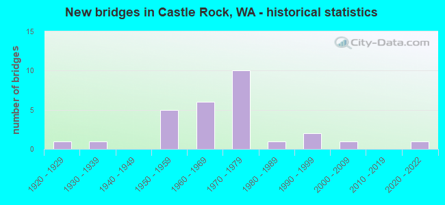
- New bridges - historical statistics
- 11920-1929
- 11930-1939
- 51950-1959
- 61960-1969
- 101970-1979
- 11980-1989
- 21990-1999
- 12000-2009
- 12020-2022


- Bridge Condition - Deck
- 5.9%Very good
- 29.4%Good
- 35.3%Satisfactory
- 23.5%Fair
- 5.9%Serious

- Bridge Condition - Superstructure
- 5.9%Very good
- 41.2%Good
- 23.5%Satisfactory
- 29.4%Fair

- Bridge Condition - Substructure
- 5.9%Very good
- 70.6%Good
- 11.8%Satisfactory
- 11.8%Fair

- Bridge Condition - Channel
- 28.6%Very good
- 28.6%Good
- 21.4%Satisfactory
- 21.4%Fair

- Bridge Condition - Culverts
- 20.0%Very good
- 40.0%Good
- 40.0%Satisfactory
Find on map >> Show street view
Structure Number: 8335A, Location: 2.1 N JCT SR 504 (Lat: 46.310472, Lng: -122.913639), Route carried "on" structure: Interstate 5, Year Built: 1969, Status: Open, Structure Length: 9.42m (30.91ft), Average Daily Traffic: 23,701 (year 2019), Truck Traffic: 19%, Average Future Daily Traffic: 31,664 (year 2039), Design Load: HS 20+Mod, Features Intersected: TOUTLE RIVER
Minimum Vertical Clearance: 9.07m (29.76ft), Kilometerpoint: 83.219, Lanes on structure: 3, Base Highway Network: Yes, Owner: State Highway Agency, Approaching Roadway Width: 17.7m (58.1ft), Material/Design: Steel, Design/Construction: Arch - Thru, Number Of Spans In Main Unit: 1, Length of Maximum Span: 92.7m (304.1ft), Curb or Sidewalk Widths: Left: 0.2m (0.7ft), Right: 0.2m (0.7ft), Curb-To-Curb Width: 14.6m (47.9ft), Out-to-Out Width: 15.7m (51.5ft)
Condition: Deck: Fair, Superstructure: Fair, Substructure: Good, Channel: Good, Operating Rating: 33.7 metric tons, Method Used To Determine Operating Rating: Load and Resistance Factor Rating (LRFR) rating reported by rating factor(RF) method using HL-93 loadings, Inventory Rating: 25.9 metric tons, Method Used To Determine Inventory Rating: Load and Resistance Factor Rating (LRFR) rating reported by rating factor(RF) method using HL-93 loadings, Structural Evaluation: Somewhat better than minimum adequacy, Deck Geometry: Meets minimum limits, Waterway Adequacy: Equal to present desirable criteria, Approach Roadway Alignment: Equal to present desirable criteria, Length Of Structure Improvement: 9.42m (30.91ft), Designated Inspection Frequency: Every 24 months, Critical Feature Inspection Frequency: Every 24 months, Inspection Date: March 2021, Critical Feature Inspection Date: March 2021, Bridge Improvement Cost: $3,708,000, Roadway Improvement Cost: $742,000, Total Project Cost: $7,416,000 ( Estimate for 2014), Deck Structure Type: Concrete Cast-file-Place, Wearing Surface/Protective System: Wearing Surface: Monolithic Concrete
Find on map >> Show street view
Structure Number: 8335B, Location: 2.1 N JCT SR 504 (Lat: 46.310389, Lng: -122.913889), Route carried "on" structure: Interstate 5, Year Built: 1969, Status: Open, Structure Length: 9.42m (30.91ft), Average Daily Traffic: 23,701 (year 2019), Truck Traffic: 19%, Average Future Daily Traffic: 31,664 (year 2039), Design Load: HS 20+Mod, Features Intersected: TOUTLE RIVER
Minimum Vertical Clearance: 9.07m (29.76ft), Kilometerpoint: 83.219, Lanes on structure: 3, Base Highway Network: Yes, Owner: State Highway Agency, Approaching Roadway Width: 17.7m (58.1ft), Material/Design: Steel, Design/Construction: Arch - Thru, Number Of Spans In Main Unit: 1, Length of Maximum Span: 92.7m (304.1ft), Curb or Sidewalk Widths: Left: 0.2m (0.7ft), Right: 0.2m (0.7ft), Curb-To-Curb Width: 14.6m (47.9ft), Out-to-Out Width: 15.7m (51.5ft)
Condition: Deck: Satisfactory, Superstructure: Fair, Substructure: Good, Channel: Good, Operating Rating: 33.7 metric tons, Method Used To Determine Operating Rating: Load and Resistance Factor Rating (LRFR) rating reported by rating factor(RF) method using HL-93 loadings, Inventory Rating: 25.9 metric tons, Method Used To Determine Inventory Rating: Load and Resistance Factor Rating (LRFR) rating reported by rating factor(RF) method using HL-93 loadings, Structural Evaluation: Somewhat better than minimum adequacy, Deck Geometry: Meets minimum limits, Waterway Adequacy: Equal to present desirable criteria, Approach Roadway Alignment: Equal to present desirable criteria, Length Of Structure Improvement: 9.42m (30.91ft), Designated Inspection Frequency: Every 24 months, Critical Feature Inspection Frequency: Every 24 months, Inspection Date: March 2021, Critical Feature Inspection Date: March 2021, Bridge Improvement Cost: $3,708,000, Roadway Improvement Cost: $742,000, Total Project Cost: $7,416,000 ( Estimate for 2014), Deck Structure Type: Concrete Cast-file-Place, Wearing Surface/Protective System: Wearing Surface: Epoxy Overlay
Find on map >> Show street view
Structure Number: 8335C, Location: 2.8 N JCT SR 504 (Lat: 46.324119, Lng: -122.913156), Route carried "on" structure: County highway , Year Built: 1968, Status: Open, Structure Length: 8.84m (29.00ft), Average Daily Traffic: 721 (year 2016), Truck Traffic: 1%, Average Future Daily Traffic: 1,040 (year 2038), Design Load: HS 20+Mod, Features Intersected: I-5, Facility Carried by Structure: OLD PACIFIC HWY N
Minimum Vertical Clearance: 30+ m (98+ ft), Kilometerpoint: 0.064, Lanes on structure: 2, Lanes under structure: 6, Owner: State Highway Agency, Approaching Roadway Width: 11.6m (38.1ft), Material/Design: Concrete continuous, Design/Construction: Box Beam or Girders - Multiple, Number Of Spans In Main Unit: 3, Length of Maximum Span: 40.8m (133.9ft), Curb or Sidewalk Widths: Left: 0.9m (3.0ft), Right: 0.9m (3.0ft), Curb-To-Curb Width: 7.9m (25.9ft), Out-to-Out Width: 10.1m (33.1ft)
Condition: Deck: Good, Superstructure: Good, Substructure: Good, Operating Rating: 66.2 metric tons, Method Used To Determine Operating Rating: Load Factor (LF), Inventory Rating: 39.0 metric tons, Method Used To Determine Inventory Rating: Load Factor (LF), Structural Evaluation: Better than present minimum criteria, Deck Geometry: Somewhat better than minimum adequacy, Underclear: Meets minimum limits, Approach Roadway Alignment: Equal to present desirable criteria, Length Of Structure Improvement: 8.84m (29.00ft), Designated Inspection Frequency: Every 24 months, Inspection Date: March 2020, Bridge Improvement Cost: $2,320,000, Roadway Improvement Cost: $464,000, Total Project Cost: $4,640,000 ( Estimate for 2014), Deck Structure Type: Concrete Cast-file-Place, Wearing Surface/Protective System: Wearing Surface: Latex Concrete
Find on map >> Show street view
Structure Number: 9580A, Location: 8.1 N JCT SR 4 (Lat: 46.259722, Lng: -122.886944), Route carried "on" structure: Interstate 5, Year Built: 1975, Status: Open, Structure Length: 5.49m (18.01ft), Average Daily Traffic: 26,100 (year 2019), Truck Traffic: 19%, Average Future Daily Traffic: 34,869 (year 2039), Design Load: HS 20+Mod, Features Intersected: HUNTINGTON AVE
Minimum Vertical Clearance: 30+ m (98+ ft), Kilometerpoint: 77.200, Lanes on structure: 3, Lanes under structure: 2, Base Highway Network: Yes, Owner: State Highway Agency, Approaching Roadway Width: 15.8m (51.8ft), Skew: 3 degrees, Material/Design: Prestressed concrete continuous, Design/Construction: Stringer/Multi-beam, Number Of Spans In Main Unit: 3, Length of Maximum Span: 25.6m (84.0ft), Curb-To-Curb Width: 15.8m (51.8ft), Out-to-Out Width: 16.8m (55.1ft)
Condition: Deck: Satisfactory, Superstructure: Fair, Substructure: Good, Operating Rating: 72.6 metric tons, Method Used To Determine Operating Rating: Load Factor (LF), Inventory Rating: 42.6 metric tons, Method Used To Determine Inventory Rating: Load Factor (LF), Structural Evaluation: Somewhat better than minimum adequacy, Deck Geometry: Somewhat better than minimum adequacy, Underclear: Equal to present minimum criteria, Approach Roadway Alignment: Equal to present desirable criteria, Length Of Structure Improvement: 5.49m (18.01ft), Designated Inspection Frequency: Every 24 months, Inspection Date: December 2021, Bridge Improvement Cost: $1,944,000, Roadway Improvement Cost: $389,000, Total Project Cost: $3,888,000 ( Estimate for 2014), Deck Structure Type: Concrete Cast-file-Place, Wearing Surface/Protective System: Wearing Surface: Monolithic Concrete
Find on map >> Show street view
Structure Number: 9580B, Location: 8.1 N JCT SR 4 (Lat: 46.259722, Lng: -122.887472), Route carried "on" structure: Interstate 5, Year Built: 1975, Status: Open, Structure Length: 6.00m (19.69ft), Average Daily Traffic: 26,100 (year 2019), Truck Traffic: 19%, Average Future Daily Traffic: 34,869 (year 2039), Design Load: HS 20+Mod, Features Intersected: HUNTINGTON AVE
Minimum Vertical Clearance: 30+ m (98+ ft), Kilometerpoint: 77.200, Lanes on structure: 3, Lanes under structure: 2, Base Highway Network: Yes, Owner: State Highway Agency, Approaching Roadway Width: 16.5m (54.1ft), Skew: 3 degrees, Material/Design: Prestressed concrete continuous, Design/Construction: Stringer/Multi-beam, Number Of Spans In Main Unit: 3, Length of Maximum Span: 25.6m (84.0ft), Curb-To-Curb Width: 15.8m (51.8ft), Out-to-Out Width: 16.8m (55.1ft)
Condition: Deck: Good, Superstructure: Good, Substructure: Good, Operating Rating: 76.2 metric tons, Method Used To Determine Operating Rating: Load Factor (LF), Inventory Rating: 45.4 metric tons, Method Used To Determine Inventory Rating: Load Factor (LF), Structural Evaluation: Better than present minimum criteria, Deck Geometry: Somewhat better than minimum adequacy, Underclear: Equal to present minimum criteria, Approach Roadway Alignment: Equal to present desirable criteria, Length Of Structure Improvement: 6.00m (19.69ft), Designated Inspection Frequency: Every 24 months, Inspection Date: December 2021, Bridge Improvement Cost: $2,206,000, Roadway Improvement Cost: $441,000, Total Project Cost: $4,413,000 ( Estimate for 2014), Deck Structure Type: Concrete Cast-file-Place, Wearing Surface/Protective System: Wearing Surface: Monolithic Concrete
Find on map >> Show street view
Structure Number: 9580C, Location: 9.3 N JCT SR 4 (Lat: 46.275472, Lng: -122.898194), Route carried "on" structure: County highway , Year Built: 1975, Status: Open, Structure Length: 10.97m (35.99ft), Average Daily Traffic: 771 (year 2020), Truck Traffic: 10%, Average Future Daily Traffic: 1,018 (year 2040), Design Load: HS 20+Mod, Features Intersected: I-5, Facility Carried by Structure: POWELL RD
Minimum Vertical Clearance: 30+ m (98+ ft), Kilometerpoint: 0.708, Lanes on structure: 2, Lanes under structure: 6, Owner: State Highway Agency, Approaching Roadway Width: 9.1m (29.9ft), Skew: 2 degrees, Material/Design: Prestressed concrete continuous, Design/Construction: Stringer/Multi-beam, Number Of Spans In Main Unit: 4, Length of Maximum Span: 38.4m (126.0ft), Curb-To-Curb Width: 8.0m (26.2ft), Out-to-Out Width: 8.9m (29.2ft)
Condition: Deck: Good, Superstructure: Good, Substructure: Good, Operating Rating: 75.3 metric tons, Method Used To Determine Operating Rating: Load Factor (LF), Inventory Rating: 45.4 metric tons, Method Used To Determine Inventory Rating: Load Factor (LF), Structural Evaluation: Better than present minimum criteria, Deck Geometry: Somewhat better than minimum adequacy, Underclear: Equal to present desirable criteria, Approach Roadway Alignment: Equal to present desirable criteria, Length Of Structure Improvement: 10.97m (35.99ft), Designated Inspection Frequency: Every 24 months, Inspection Date: December 2021, Bridge Improvement Cost: $2,304,000, Roadway Improvement Cost: $461,000, Total Project Cost: $4,608,000 ( Estimate for 2014), Deck Structure Type: Concrete Cast-file-Place, Wearing Surface/Protective System: Wearing Surface: Monolithic Concrete
Find on map >> Show street view
Structure Number: 9580D, Location: JCT I-5 (Lat: 46.284250, Lng: -122.903083), Route carried "on" structure: State highway 504, Year Built: 1975, Status: Open, Structure Length: 8.87m (29.10ft), Average Daily Traffic: 9,174 (year 2019), Truck Traffic: 6%, Average Future Daily Traffic: 12,256 (year 2039), Design Load: HS 20+Mod, Features Intersected: I-5
Minimum Vertical Clearance: 30+ m (98+ ft), Kilometerpoint: 0.001, Lanes on structure: 3, Lanes under structure: 6, Base Highway Network: Yes, Owner: State Highway Agency, Approaching Roadway Width: 17.1m (56.1ft), Skew: 2 degrees, Material/Design: Prestressed concrete continuous, Design/Construction: Stringer/Multi-beam, Number Of Spans In Main Unit: 2, Length of Maximum Span: 43.0m (141.1ft), Curb-To-Curb Width: 17.1m (56.1ft), Out-to-Out Width: 18.0m (59.1ft)
Condition: Deck: Satisfactory, Superstructure: Good, Substructure: Good, Operating Rating: 72.6 metric tons, Method Used To Determine Operating Rating: Load Factor (LF), Inventory Rating: 42.6 metric tons, Method Used To Determine Inventory Rating: Load Factor (LF), Structural Evaluation: Better than present minimum criteria, Deck Geometry: Superior to present desirable criteria, Underclear: Somewhat better than minimum adequacy, Approach Roadway Alignment: Equal to present desirable criteria, Length Of Structure Improvement: 8.87m (29.10ft), Designated Inspection Frequency: Every 24 months, Inspection Date: July 2021, Bridge Improvement Cost: $3,376,000, Roadway Improvement Cost: $675,000, Total Project Cost: $6,751,000 ( Estimate for 2014), Deck Structure Type: Concrete Cast-file-Place, Wearing Surface/Protective System: Wearing Surface: Monolithic Concrete
Find on map >> Show street view
Structure Number: 9597E, Location: 6.3 N JCT SR 4 (Lat: 46.233808, Lng: -122.888314), Route carried "on" structure: County highway , Year Built: 1975, Status: Open, Structure Length: 12.41m (40.72ft), Average Daily Traffic: 936 (year 2017), Truck Traffic: 1%, Average Future Daily Traffic: 1,337 (year 2039), Design Load: HS 20+Mod, Features Intersected: I-5, Facility Carried by Structure: HEADQUARTERS RD
Minimum Vertical Clearance: 30+ m (98+ ft), Kilometerpoint: 0.048, Lanes on structure: 2, Lanes under structure: 6, Owner: State Highway Agency, Approaching Roadway Width: 17.1m (56.1ft), Material/Design: Prestressed concrete continuous, Design/Construction: Stringer/Multi-beam, Number Of Spans In Main Unit: 5, Length of Maximum Span: 31.7m (104.0ft), Curb-To-Curb Width: 10.5m (34.4ft), Out-to-Out Width: 11.4m (37.4ft)
Condition: Deck: Good, Superstructure: Good, Substructure: Good, Operating Rating: 53.5 metric tons, Method Used To Determine Operating Rating: Load Factor (LF), Inventory Rating: 32.7 metric tons, Method Used To Determine Inventory Rating: Load Factor (LF), Structural Evaluation: Better than present minimum criteria, Deck Geometry: Equal to present minimum criteria, Underclear: Better than present minimum criteria, Approach Roadway Alignment: Equal to present desirable criteria, Length Of Structure Improvement: 12.41m (40.72ft), Designated Inspection Frequency: Every 24 months, Inspection Date: October 2021, Bridge Improvement Cost: $4,721,000, Roadway Improvement Cost: $944,000, Total Project Cost: $9,442,000 ( Estimate for 2014), Deck Structure Type: Concrete Cast-file-Place, Wearing Surface/Protective System: Wearing Surface: Monolithic Concrete
Find on map >> Show street view
Structure Number: 11968A, Location: 11.3 N JCT SR 432 (Lat: 46.265611, Lng: -122.925750), Route carried "on" structure: State highway 411, Year Built: 1981, Status: Open, Structure Length: 5.06m (16.60ft), Average Daily Traffic: 4,103 (year 2019), Truck Traffic: 6%, Average Future Daily Traffic: 5,481 (year 2039), Design Load: HS 20+Mod, Features Intersected: ARKANSAS CREEK
Minimum Vertical Clearance: 30+ m (98+ ft), Kilometerpoint: 18.121, Lanes on structure: 2, Base Highway Network: Yes, Owner: State Highway Agency, Approaching Roadway Width: 12.2m (40.0ft), Material/Design: Prestressed concrete continuous, Design/Construction: Stringer/Multi-beam, Number Of Spans In Main Unit: 3, Length of Maximum Span: 16.8m (55.1ft), Curb-To-Curb Width: 12.2m (40.0ft), Out-to-Out Width: 13.1m (43.0ft)
Condition: Deck: Good, Superstructure: Good, Substructure: Good, Channel: Good, Operating Rating: 59.6 metric tons, Method Used To Determine Operating Rating: Load and Resistance Factor Rating (LRFR) rating reported by rating factor(RF) method using HL-93 loadings, Inventory Rating: 21.1 metric tons, Method Used To Determine Inventory Rating: Load and Resistance Factor Rating (LRFR) rating reported by rating factor(RF) method using HL-93 loadings, Structural Evaluation: Somewhat better than minimum adequacy, Deck Geometry: Equal to present minimum criteria, Waterway Adequacy: Equal to present desirable criteria, Approach Roadway Alignment: Equal to present desirable criteria, Length Of Structure Improvement: 5.06m (16.60ft), Designated Inspection Frequency: Every 24 months, Inspection Date: September 2021, Bridge Improvement Cost: $1,394,000, Roadway Improvement Cost: $279,000, Total Project Cost: $2,789,000 ( Estimate for 2014), Deck Structure Type: Other, Wearing Surface/Protective System: Wearing Surface: Bituminous, Membrane: Preformed Fabric
Find on map >> Show street view
Structure Number: 80896, Location: 0.57 N DELAMETER RD (0.89 (Lat: 46.279444, Lng: -122.945000), Route carried "on" structure: County highway 25510, Year Built: 1959, Status: Posted for load, Structure Length: 2.41m (7.91ft), Average Daily Traffic: 115 (year 2019), Truck Traffic: 3%, Average Future Daily Traffic: 165 (year 2039), Design Load: HS 15, Features Intersected: ARKANSAS CREEK, Facility Carried by Structure: CLINE RD
Minimum Vertical Clearance: 30+ m (98+ ft), Kilometerpoint: 0.001, Lanes on structure: 2, Owner: County Highway Agency, Approaching Roadway Width: 7.3m (24.0ft), Material/Design: Concrete continuous, Design/Construction: Slab, Number Of Spans In Main Unit: 3, Length of Maximum Span: 9.8m (32.2ft), Curb or Sidewalk Widths: Left: 0.2m (0.7ft), Right: 0.2m (0.7ft), Curb-To-Curb Width: 7.3m (24.0ft), Out-to-Out Width: 8.5m (27.9ft)
Condition: Deck: Satisfactory, Superstructure: Satisfactory, Substructure: Satisfactory, Channel: Fair, Operating Rating: 18.1 metric tons, Method Used To Determine Operating Rating: Load Factor (LF), Inventory Rating: 10.9 metric tons, Method Used To Determine Inventory Rating: Load Factor (LF), Structural Evaluation: Meets minimum limits, Deck Geometry: Somewhat better than minimum adequacy, Waterway Adequacy: Equal to present desirable criteria, Approach Roadway Alignment: Equal to present minimum criteria, Bridge Posting: Required (Relationship of Operating Rating to Maximum Legal Load: > 39.9% below), Length Of Structure Improvement: 2.71m (8.89ft), Designated Inspection Frequency: Every 24 months, Inspection Date: September 2021, Bridge Improvement Cost: $1,353,000, Roadway Improvement Cost: $271,000, Total Project Cost: $2,706,000 ( Estimate for 2014), Deck Structure Type: Concrete Cast-file-Place
Find on map >> Show street view
Structure Number: 81062, Location: 12.4 N JCT SR 432 (Lat: 46.275047, Lng: -122.914611), Route carried "on" structure: State highway 411, Year Built: 1963, Status: Open, Structure Length: 14.75m (48.39ft), Average Daily Traffic: 6,580 (year 2019), Truck Traffic: 7%, Average Future Daily Traffic: 8,790 (year 2039), Design Load: HS 20, Features Intersected: COWLITZ RIVER
Minimum Vertical Clearance: 30+ m (98+ ft), Kilometerpoint: 19.908, Lanes on structure: 2, Base Highway Network: Yes, Owner: State Highway Agency, Approaching Roadway Width: 8.5m (27.9ft), Material/Design: Steel continuous, Design/Construction: Stringer/Multi-beam, Number Of Spans In Main Unit: 5, Length of Maximum Span: 39.6m (129.9ft), Curb or Sidewalk Widths: Left: 0.9m (3.0ft), Right: 0.9m (3.0ft), Curb-To-Curb Width: 8.5m (27.9ft), Out-to-Out Width: 10.4m (34.1ft)
Condition: Deck: Serious, Superstructure: Satisfactory, Substructure: Good, Channel: Very good, Operating Rating: 71.7 metric tons, Method Used To Determine Operating Rating: Load Factor (LF), Inventory Rating: 36.3 metric tons, Method Used To Determine Inventory Rating: Load Factor (LF), Structural Evaluation: Equal to present minimum criteria, Deck Geometry: Meets minimum limits, Waterway Adequacy: Equal to present desirable criteria, Approach Roadway Alignment: Equal to present desirable criteria, Length Of Structure Improvement: 14.75m (48.39ft), Designated Inspection Frequency: Every 24 months, Underwater Inspection Frequency: Every 60 months, Other Special Inspection Frequency: Every 24 months, Inspection Date: April 2021, Underwater Inspection Date: August 2021, Other Special Inspection Date: April 2021, Bridge Improvement Cost: $2,904,000, Roadway Improvement Cost: $581,000, Total Project Cost: $5,808,000 ( Estimate for 2014), Deck Structure Type: Concrete Cast-file-Place, Wearing Surface/Protective System: Wearing Surface: Monolithic Concrete
Find on map >> Show street view
Structure Number: 81276, Location: 13.3 N JCT SR 432 (Lat: 46.282028, Lng: -122.906472), Route carried "on" structure: State highway 411, Year Built: 1922, Year Reconstructed: 1972, Status: Posted for load, Structure Length: 4.48m (14.70ft), Average Daily Traffic: 5,164 (year 2019), Truck Traffic: 7%, Average Future Daily Traffic: 6,899 (year 2039), Design Load: HS 15, Features Intersected: BURLINGTON NORTHERN RR
Minimum Vertical Clearance: 30+ m (98+ ft), Kilometerpoint: 21.340, Lanes on structure: 2, Base Highway Network: Yes, Owner: State Highway Agency, Approaching Roadway Width: 10.4m (34.1ft), Skew: 4 degrees, Material/Design: Concrete continuous, Design/Construction: Tee Beam, Number Of Spans In Main Unit: 5, Length of Maximum Span: 12.2m (40.0ft), Curb or Sidewalk Widths: Left: 1.5m (4.9ft), Right: 0.0m, Curb-To-Curb Width: 8.5m (27.9ft), Out-to-Out Width: 11.0m (36.1ft)
Condition: Deck: Fair, Superstructure: Fair, Substructure: Fair, Operating Rating: 40.8 metric tons, Method Used To Determine Operating Rating: Load Factor (LF), Inventory Rating: 24.5 metric tons, Method Used To Determine Inventory Rating: Load Factor (LF), Structural Evaluation: Somewhat better than minimum adequacy, Deck Geometry: High priority of replacement, Underclear: Meets minimum limits, Approach Roadway Alignment: Equal to present desirable criteria, Bridge Posting: Required (Relationship of Operating Rating to Maximum Legal Load: 20.0 - 29.9% below), Length Of Structure Improvement: 4.48m (14.70ft), Designated Inspection Frequency: Every 24 months, Inspection Date: September 2020, Bridge Improvement Cost: $1,058,000, Roadway Improvement Cost: $212,000, Total Project Cost: $2,117,000 ( Estimate for 2014), Deck Structure Type: Concrete Cast-file-Place, Wearing Surface/Protective System: Wearing Surface: Bituminous
Find on map >> Show street view
Structure Number: 81961, Location: 0.02 S DELAMETER RD (0.17 (Lat: 46.267500, Lng: -122.929167), Route carried "on" structure: County highway 24510, Year Built: 1960, Status: Posted for load, Structure Length: 3.14m (10.30ft), Average Daily Traffic: 190 (year 2018), Truck Traffic: 2%, Average Future Daily Traffic: 275 (year 2038), Design Load: HS 20, Features Intersected: ARKANSAS CREEK, Facility Carried by Structure: WREN LOOP RD
Minimum Vertical Clearance: 30+ m (98+ ft), Kilometerpoint: 0.001, Lanes on structure: 2, Owner: County Highway Agency, Approaching Roadway Width: 8.2m (26.9ft), Material/Design: Concrete continuous, Design/Construction: Slab, Number Of Spans In Main Unit: 4, Length of Maximum Span: 8.5m (27.9ft), Curb or Sidewalk Widths: Left: 0.5m (1.6ft), Right: 0.5m (1.6ft), Curb-To-Curb Width: 7.9m (25.9ft), Out-to-Out Width: 9.8m (32.2ft)
Condition: Deck: Fair, Superstructure: Fair, Substructure: Fair, Channel: Satisfactory, Operating Rating: 23.6 metric tons, Method Used To Determine Operating Rating: Load Factor (LF), Inventory Rating: 13.6 metric tons, Method Used To Determine Inventory Rating: Load Factor (LF), Structural Evaluation: Meets minimum limits, Deck Geometry: Somewhat better than minimum adequacy, Waterway Adequacy: Equal to present desirable criteria, Approach Roadway Alignment: Equal to present desirable criteria, Bridge Posting: Required (Relationship of Operating Rating to Maximum Legal Load: > 39.9% below), Length Of Structure Improvement: 3.44m (11.29ft), Designated Inspection Frequency: Every 24 months, Inspection Date: September 2021, Bridge Improvement Cost: $1,718,000, Roadway Improvement Cost: $344,000, Total Project Cost: $3,435,000 ( Estimate for 2014), Deck Structure Type: Concrete Cast-file-Place
Find on map >> Show street view
Structure Number: 82114, Location: 0.91 W SR 411 (MP 11.33) (Lat: 46.271667, Lng: -122.941944), Route carried "on" structure: County highway 20901, Year Built: 1958, Status: Open, Structure Length: 2.56m (8.40ft), Average Daily Traffic: 1,203 (year 2019), Truck Traffic: 4%, Average Future Daily Traffic: 1,720 (year 2039), Design Load: HS 20, Features Intersected: DELAMETER CREEK, Facility Carried by Structure: DELAMETER RD
Minimum Vertical Clearance: 30+ m (98+ ft), Kilometerpoint: 0.001, Lanes on structure: 2, Owner: County Highway Agency, Approaching Roadway Width: 7.6m (24.9ft), Material/Design: Concrete continuous, Design/Construction: Slab, Number Of Spans In Main Unit: 3, Length of Maximum Span: 8.5m (27.9ft), Curb or Sidewalk Widths: Left: 0.9m (3.0ft), Right: 0.9m (3.0ft), Curb-To-Curb Width: 7.9m (25.9ft), Out-to-Out Width: 10.4m (34.1ft)
Condition: Deck: Fair, Superstructure: Satisfactory, Substructure: Satisfactory, Channel: Good, Operating Rating: 32.7 metric tons, Method Used To Determine Operating Rating: Field evaluation and documented engineering judgment, Inventory Rating: 18.1 metric tons, Method Used To Determine Inventory Rating: Field evaluation and documented engineering judgment, Structural Evaluation: Somewhat better than minimum adequacy, Deck Geometry: Meets minimum limits, Waterway Adequacy: Better than present minimum criteria, Approach Roadway Alignment: Equal to present desirable criteria, Length Of Structure Improvement: 2.87m (9.42ft), Designated Inspection Frequency: Every 24 months, Inspection Date: September 2021, Bridge Improvement Cost: $1,429,000, Roadway Improvement Cost: $286,000, Total Project Cost: $2,858,000 ( Estimate for 2014), Deck Structure Type: Concrete Cast-file-Place
Find on map >> Show street view
Structure Number: 83668, Location: 0.29 SE I-5 EXIT 52 (Lat: 46.319167, Lng: -122.909167), Route carried "on" structure: County highway 56930, Year Built: 1935, Status: Posted for load, Structure Length: 11.16m (36.61ft), Average Daily Traffic: 509 (year 2015), Truck Traffic: 14%, Average Future Daily Traffic: 875 (year 2032), Design Load: H 20, Features Intersected: TOUTLE RIVER, Facility Carried by Structure: OLD PACIFIC HWY N
Minimum Vertical Clearance: 5.21m (17.09ft), Kilometerpoint: 0.001, Lanes on structure: 2, Owner: County Highway Agency, Approaching Roadway Width: 9.4m (30.8ft), Material/Design: Steel, Design/Construction: Truss - Thru, Number Of Spans In Main Unit: 1, Number Of Approach Spans: 2, Length of Maximum Span: 73.2m (240.2ft), Curb-To-Curb Width: 13.4m (44.0ft), Out-to-Out Width: 15.2m (49.9ft)
Condition: Deck: Satisfactory, Superstructure: Satisfactory, Substructure: Good, Channel: Satisfactory, Operating Rating: 32.7 metric tons, Method Used To Determine Operating Rating: Load Factor (LF), Inventory Rating: 19.0 metric tons, Method Used To Determine Inventory Rating: Load Factor (LF), Structural Evaluation: Somewhat better than minimum adequacy, Deck Geometry: Better than present minimum criteria, Waterway Adequacy: Equal to present desirable criteria, Approach Roadway Alignment: Equal to present desirable criteria, Bridge Posting: Required (Relationship of Operating Rating to Maximum Legal Load: 20.0 - 29.9% below), Designated Inspection Frequency: Every 24 months, Critical Feature Inspection Frequency: Every 24 months, Inspection Date: March 2021, Critical Feature Inspection Date: March 2021, Deck Structure Type: Concrete Cast-file-Place
Find on map >> Show street view
Structure Number: 86423, Location: 0.63 W WSH (MP 0.90) (Lat: 46.290000, Lng: -122.930278), Route carried "on" structure: County highway 26300, Year Built: 1999, Status: Open, Structure Length: 0.64m (2.10ft), Average Daily Traffic: 130 (year 2019), Truck Traffic: 5%, Average Future Daily Traffic: 185 (year 2039), Design Load: HS 25 or greater, Features Intersected: WHITTLE CREEK, Facility Carried by Structure: QUICK RD
Minimum Vertical Clearance: 30+ m (98+ ft), Kilometerpoint: 0.001, Lanes on structure: 2, Owner: County Highway Agency, Approaching Roadway Width: 6.7m (22.0ft), Skew: 1 degrees, Material/Design: Concrete, Design/Construction: Culvert, Number Of Spans In Main Unit: 1, Length of Maximum Span: 6.4m (21.0ft)
Condition: Channel: Very good, Culverts: Good, Operating Rating: 89.8 metric tons, Method Used To Determine Operating Rating: Field evaluation and documented engineering judgment, Inventory Rating: 89.8 metric tons, Method Used To Determine Inventory Rating: Field evaluation and documented engineering judgment, Structural Evaluation: Better than present minimum criteria, Waterway Adequacy: Equal to present desirable criteria, Approach Roadway Alignment: Equal to present desirable criteria, Length Of Structure Improvement: 0.64m (2.10ft), Designated Inspection Frequency: Every 24 months, Inspection Date: September 2021, Bridge Improvement Cost: $101,000, Roadway Improvement Cost: $20,000, Total Project Cost: $202,000 ( Estimate for 2014)
Find on map >> Show street view
Structure Number: 86835, Location: 0.13 W OF I-5 EXIT 48 (Lat: 46.260278, Lng: -122.890000), Route carried "on" structure: City street 50250, Year Built: 1994, Status: Open, Structure Length: 5.79m (19.00ft), Average Daily Traffic: 3,642 (year 2017), Truck Traffic: 11%, Average Future Daily Traffic: 4,880 (year 2039), Design Load: HS 25 or greater, Features Intersected: BNRR, Facility Carried by Structure: HUNTINGTON AVE
Minimum Vertical Clearance: 30+ m (98+ ft), Kilometerpoint: 0.001, Lanes on structure: 2, Owner: City or Municipal Highway Agency, Approaching Roadway Width: 12.2m (40.0ft), Skew: 3 degrees, Material/Design: Prestressed concrete continuous, Design/Construction: Stringer/Multi-beam, Number Of Spans In Main Unit: 3, Length of Maximum Span: 26.8m (87.9ft), Curb-To-Curb Width: 12.2m (40.0ft), Out-to-Out Width: 13.4m (44.0ft)
Condition: Deck: Satisfactory, Superstructure: Good, Substructure: Good, Operating Rating: 89.8 metric tons, Method Used To Determine Operating Rating: Load Factor (LF), Inventory Rating: 60.8 metric tons, Method Used To Determine Inventory Rating: Load Factor (LF), Structural Evaluation: Better than present minimum criteria, Deck Geometry: Equal to present minimum criteria, Underclear: Superior to present desirable criteria, Approach Roadway Alignment: Equal to present desirable criteria, Length Of Structure Improvement: 5.79m (19.00ft), Designated Inspection Frequency: Every 24 months, Inspection Date: October 2021, Bridge Improvement Cost: $1,596,000, Roadway Improvement Cost: $319,000, Total Project Cost: $3,192,000 ( Estimate for 2014), Deck Structure Type: Concrete Cast-file-Place, Wearing Surface/Protective System: Deck Protection: Epoxy Coated Reinforcing
Find on map >> Show street view
Structure Number: 87281, Location: 2.74 W SR411 (MP11.33) (Lat: 46.263611, Lng: -122.973889), Route carried "on" structure: County highway 20901, Year Built: 2003, Status: Open, Structure Length: 0.98m (3.22ft), Average Daily Traffic: 727 (year 2019), Truck Traffic: 5%, Average Future Daily Traffic: 1,040 (year 2039), Design Load: HS 25 or greater, Features Intersected: MONAHAN CREEK, Facility Carried by Structure: DELAMETER RD
Minimum Vertical Clearance: 30+ m (98+ ft), Kilometerpoint: 0.001, Lanes on structure: 2, Owner: County Highway Agency, Approaching Roadway Width: 9.4m (30.8ft), Material/Design: Steel, Design/Construction: Culvert, Number Of Spans In Main Unit: 1, Length of Maximum Span: 9.8m (32.2ft)
Condition: Channel: Very good, Culverts: Very good, Operating Rating: 74.4 metric tons, Method Used To Determine Operating Rating: Load Factor (LF), Inventory Rating: 71.7 metric tons, Method Used To Determine Inventory Rating: Load Factor (LF), Structural Evaluation: Equal to present desirable criteria, Waterway Adequacy: Equal to present desirable criteria, Approach Roadway Alignment: Equal to present desirable criteria, Length Of Structure Improvement: 0.98m (3.22ft), Designated Inspection Frequency: Every 24 months, Inspection Date: September 2021, Bridge Improvement Cost: $211,000, Roadway Improvement Cost: $42,000, Total Project Cost: $422,000 ( Estimate for 2014)
Find on map >> Show street view
Structure Number: 87287, Location: 0.27 W PH 10 (MP 2.83) (Lat: 46.293333, Lng: -122.955556), Route carried "on" structure: County highway 27100, Year Built: 1953, Status: Open, Structure Length: 0.64m (2.10ft), Average Daily Traffic: 134 (year 2019), Truck Traffic: 1%, Average Future Daily Traffic: 180 (year 2039), Design Load: HS 15, Features Intersected: ARKANSAS CREEK, Facility Carried by Structure: GROWLERS GULCH RD
Minimum Vertical Clearance: 30+ m (98+ ft), Kilometerpoint: 0.001, Lanes on structure: 2, Owner: County Highway Agency, Approaching Roadway Width: 6.4m (21.0ft), Material/Design: Concrete continuous, Design/Construction: Culvert, Number Of Spans In Main Unit: 2, Length of Maximum Span: 3.0m (9.8ft)
Condition: Channel: Satisfactory, Culverts: Good, Operating Rating: 89.8 metric tons, Method Used To Determine Operating Rating: Load Factor (LF), Inventory Rating: 55.3 metric tons, Method Used To Determine Inventory Rating: Load Factor (LF), Structural Evaluation: Better than present minimum criteria, Waterway Adequacy: Equal to present desirable criteria, Approach Roadway Alignment: Equal to present desirable criteria, Length Of Structure Improvement: 0.94m (3.08ft), Designated Inspection Frequency: Every 24 months, Inspection Date: September 2021, Bridge Improvement Cost: $471,000, Roadway Improvement Cost: $94,000, Total Project Cost: $942,000 ( Estimate for 2014)
Find on map >> Show street view
Structure Number: 87288, Location: 1.56 W SR411 (MP 11.33) (Lat: 46.268611, Lng: -122.953889), Route carried "on" structure: County highway 20901, Year Built: 1954, Status: Open, Structure Length: 0.76m (2.49ft), Average Daily Traffic: 1,176 (year 2019), Truck Traffic: 4%, Average Future Daily Traffic: 1,680 (year 2039), Design Load: HS 15, Features Intersected: DELAMETER CREEK, Facility Carried by Structure: DELAMETER RD
Minimum Vertical Clearance: 30+ m (98+ ft), Kilometerpoint: 0.001, Lanes on structure: 2, Owner: County Highway Agency, Approaching Roadway Width: 7.9m (25.9ft), Material/Design: Concrete continuous, Design/Construction: Culvert, Number Of Spans In Main Unit: 2, Length of Maximum Span: 3.7m (12.1ft), Curb-To-Curb Width: 9.1m (29.9ft), Out-to-Out Width: 10.0m (32.8ft)
Condition: Channel: Fair, Culverts: Satisfactory, Operating Rating: 20.9 metric tons, Method Used To Determine Operating Rating: Load Factor (LF), Inventory Rating: 12.7 metric tons, Method Used To Determine Inventory Rating: Load Factor (LF), Structural Evaluation: Meets minimum limits, Deck Geometry: Somewhat better than minimum adequacy, Waterway Adequacy: Better than present minimum criteria, Approach Roadway Alignment: Equal to present desirable criteria, Length Of Structure Improvement: 1.07m (3.51ft), Designated Inspection Frequency: Every 24 months, Inspection Date: September 2021, Bridge Improvement Cost: $532,000, Roadway Improvement Cost: $106,000, Total Project Cost: $1,064,000 ( Estimate for 2014)
Find on map >> Show street view
Structure Number: 87289, Location: 0.59 W SR 411 (MP 11.33) (Lat: 46.271667, Lng: -122.935278), Route carried "on" structure: County highway 20901, Year Built: 1953, Status: Open, Structure Length: 1.22m (4.00ft), Average Daily Traffic: 1,400 (year 2018), Truck Traffic: 5%, Average Future Daily Traffic: 2,000 (year 2038), Design Load: HS 15, Features Intersected: ARKANSAS CREEK, Facility Carried by Structure: DELAMETER RD
Minimum Vertical Clearance: 30+ m (98+ ft), Kilometerpoint: 0.001, Lanes on structure: 2, Owner: County Highway Agency, Approaching Roadway Width: 11.6m (38.1ft), Material/Design: Concrete continuous, Design/Construction: Culvert, Number Of Spans In Main Unit: 3, Length of Maximum Span: 3.7m (12.1ft)
Condition: Channel: Fair, Culverts: Satisfactory, Operating Rating: 59.9 metric tons, Method Used To Determine Operating Rating: Load Factor (LF), Inventory Rating: 35.4 metric tons, Method Used To Determine Inventory Rating: Load Factor (LF), Structural Evaluation: Equal to present minimum criteria, Waterway Adequacy: High priority of corrective action, Approach Roadway Alignment: Equal to present desirable criteria, Length Of Structure Improvement: 1.52m (4.99ft), Designated Inspection Frequency: Every 24 months, Inspection Date: September 2021, Bridge Improvement Cost: $760,000, Roadway Improvement Cost: $152,000, Total Project Cost: $1,520,000 ( Estimate for 2014)
Find on map >> Show street view
Structure Number: 89198, Location: 0.16W OF PH10 (MP 4.15) (Lat: 46.305556, Lng: -122.972500), Route carried "on" structure: County highway 27120, Year Built: 2020, Status: Open, Structure Length: 3.20m (10.50ft), Average Daily Traffic: 65 (year 2020), Truck Traffic: 2%, Average Future Daily Traffic: 75 (year 2040), Design Load: HL 93, Features Intersected: BAXTER CREEK, Facility Carried by Structure: COYOTE LANE
Minimum Vertical Clearance: 30+ m (98+ ft), Kilometerpoint: 0.001, Lanes on structure: 2, Owner: County Highway Agency, Approaching Roadway Width: 7.3m (24.0ft), Skew: 2 degrees, Material/Design: Prestressed concrete, Design/Construction: Tee Beam, Number Of Spans In Main Unit: 1, Length of Maximum Span: 30.2m (99.1ft), Curb-To-Curb Width: 7.3m (24.0ft), Out-to-Out Width: 8.2m (26.9ft)
Condition: Deck: Very good, Superstructure: Very good, Substructure: Very good, Channel: Very good, Operating Rating: 48.3 metric tons, Method Used To Determine Operating Rating: Load and Resistance Factor Rating (LRFR) rating reported by rating factor(RF) method using HL-93 loadings, Inventory Rating: 32.7 metric tons, Method Used To Determine Inventory Rating: Load and Resistance Factor Rating (LRFR) rating reported by rating factor(RF) method using HL-93 loadings, Structural Evaluation: Equal to present desirable criteria, Deck Geometry: Equal to present minimum criteria, Waterway Adequacy: Equal to present desirable criteria, Approach Roadway Alignment: Equal to present desirable criteria, Length Of Structure Improvement: 3.51m (11.52ft), Designated Inspection Frequency: Every 24 months, Inspection Date: March 2021, Bridge Improvement Cost: $2,076,000, Roadway Improvement Cost: $415,000, Total Project Cost: $4,152,000 ( Estimate for 2022), Deck Structure Type: Other, Wearing Surface/Protective System: Wearing Surface: Bituminous, Membrane: Epoxy, Deck Protection: Epoxy Coated Reinforcing
Find on map >> Show street view
Structure Number: 8335C, Location: 2.8 N JCT SR 504 (Lat: 46.324119, Lng: -122.913156), Route carried "under" structure: Interstate 5, Year Built: 1968, Structure Length: 0. m, Average Daily Traffic: 46,302 (year 2019), Truck Traffic: 19%, Features Intersected: I-5, Facility Carried by Structure: OLD PACIFIC HWY N
Minimum Vertical Clearance: 5.64m (18.50ft), Kilometerpoint: 84.732, Lanes on structure: 2, Lanes under structure: 6, Material/Design: Concrete continuous, Design/Construction: Box Beam or Girders - Multiple, Length of Maximum Span: 40.8m (133.9ft)
Find on map >> Show street view
Structure Number: 9580A, Location: 8.1 N JCT SR 4 (Lat: 46.259722, Lng: -122.886944), Route carried "under" structure: City street , Year Built: 1975, Structure Length: 0. m, Average Daily Traffic: 2,204 (year 2017), Truck Traffic: 7%, Features Intersected: HUNTINGTON AVE, Facility Carried by Structure: I-5
Minimum Vertical Clearance: 4.75m (15.58ft), Kilometerpoint: 0.113, Lanes on structure: 3, Lanes under structure: 2, Material/Design: Prestressed concrete continuous, Design/Construction: Stringer/Multi-beam, Length of Maximum Span: 25.6m (84.0ft)
Find on map >> Show street view
Structure Number: 9580B, Location: 8.1 N JCT SR 4 (Lat: 46.259722, Lng: -122.887472), Route carried "under" structure: City street , Year Built: 1975, Structure Length: 0. m, Average Daily Traffic: 2,204 (year 2017), Truck Traffic: 7%, Features Intersected: HUNTINGTON AVE, Facility Carried by Structure: I-5
Minimum Vertical Clearance: 5.11m (16.77ft), Kilometerpoint: 0.048, Lanes on structure: 3, Lanes under structure: 2, Material/Design: Prestressed concrete continuous, Design/Construction: Stringer/Multi-beam, Length of Maximum Span: 25.6m (84.0ft)
Find on map >> Show street view
Structure Number: 9580C, Location: 9.3 N JCT SR 4 (Lat: 46.275472, Lng: -122.898194), Route carried "under" structure: Interstate 5, Year Built: 1975, Structure Length: 0. m, Average Daily Traffic: 52,450 (year 2019), Truck Traffic: 19%, Features Intersected: I-5, Facility Carried by Structure: POWELL RD
Minimum Vertical Clearance: 5.99m (19.65ft), Kilometerpoint: 79.115, Lanes on structure: 2, Lanes under structure: 6, Material/Design: Prestressed concrete continuous, Design/Construction: Stringer/Multi-beam, Length of Maximum Span: 38.4m (126.0ft)
Find on map >> Show street view
Structure Number: 9580D, Location: 10.0 N JCT SR 4 (Lat: 46.284250, Lng: -122.903083), Route carried "under" structure: Interstate 5, Year Built: 1975, Structure Length: 0. m, Average Daily Traffic: 43,375 (year 2019), Truck Traffic: 19%, Features Intersected: I-5
Minimum Vertical Clearance: 5.44m (17.85ft), Kilometerpoint: 80.210, Lanes on structure: 3, Lanes under structure: 6, Material/Design: Prestressed concrete continuous, Design/Construction: Stringer/Multi-beam, Length of Maximum Span: 43.0m (141.1ft)
Find on map >> Show street view
Structure Number: 9597E, Location: 6.3 N JCT SR 4 (Lat: 46.233808, Lng: -122.888314), Route carried "under" structure: Interstate 5, Year Built: 1975, Structure Length: 0. m, Average Daily Traffic: 56,103 (year 2019), Truck Traffic: 19%, Features Intersected: I-5, Facility Carried by Structure: HEADQUARTERS RD
Minimum Vertical Clearance: 5.59m (18.34ft), Kilometerpoint: 74.239, Lanes on structure: 2, Lanes under structure: 6, Material/Design: Prestressed concrete continuous, Design/Construction: Stringer/Multi-beam, Length of Maximum Span: 31.7m (104.0ft)