Bridge Statistics for Cass City, Michigan (MI)
Condition, Traffic, Stress, Structural Evaluation, Project Costs
- National Bridge Inventory (NBI) Statistics
- 10Number of bridges
- 85ft / 26.0mTotal length
- $217,000Total costs
- 10,318Total average daily traffic
- 350Total average daily truck traffic
- 16,657Total future (year 2028) average daily traffic
- National Bridge Inventory (NBI) Registered Bridges for Cass City
- No street view available for this location
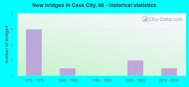
- New bridges - historical statistics
- 61970-1979
- 11980-1989
- 22000-2009
- 12010-2019

- Bridge Condition - Deck
- 14.3%Very good
- 57.1%Good
- 14.3%Satisfactory
- 14.3%Fair

- Bridge Condition - Superstructure
- 14.3%Very good
- 57.1%Good
- 28.6%Satisfactory

- Bridge Condition - Substructure
- 28.6%Very good
- 42.9%Good
- 14.3%Satisfactory
- 14.3%Fair

- Bridge Condition - Channel
- 10.0%Very good
- 20.0%Good
- 30.0%Satisfactory
- 40.0%Fair

- Bridge Condition - Culverts
- 33.3%Good
- 33.3%Satisfactory
- 33.3%Poor
Find on map >> Show street view
Structure Number: 10436, Location: 1.1 MI W OF SANILAC COL (Lat: 43.601825, Lng: -83.136622), Route carried "on" structure: State highway 81, Year Built: 1977, Status: Open, Structure Length: 2.28m (7.48ft), Average Daily Traffic: 2,500 (year 2010), Truck Traffic: 7%, Average Future Daily Traffic: 3,800 (year 2030), Design Load: HS 20, Features Intersected: N BRANCH CASS RIVER
Minimum Vertical Clearance: 30.48m (100.00ft), Kilometerpoint: 40.309, Lanes on structure: 2, Base Highway Network: Yes (Inventory Route: 27, Subroute: 4), Owner: State Highway Agency, Approaching Roadway Width: 12.8m (42.0ft), Material/Design: Prestressed concrete, Design/Construction: Box Beam or Girders - Multiple, Number Of Spans In Main Unit: 1, Length of Maximum Span: 22.8m (74.8ft), Curb-To-Curb Width: 14.2m (46.6ft), Out-to-Out Width: 15.0m (49.2ft)
Condition: Deck: Satisfactory, Superstructure: Satisfactory, Substructure: Satisfactory, Channel: Good, Operating Rating: 69.0 metric tons, Method Used To Determine Operating Rating: Load Factor (LF) rating reported by rating factor (RF) method using MS18 loading, Inventory Rating: 38.9 metric tons, Method Used To Determine Inventory Rating: Load Factor (LF) rating reported by rating factor (RF) method using MS18 loading, Structural Evaluation: Equal to present minimum criteria, Deck Geometry: Superior to present desirable criteria, Waterway Adequacy: Equal to present minimum criteria, Approach Roadway Alignment: Equal to present desirable criteria, Designated Inspection Frequency: Every 24 months, Inspection Date: September 2021, Deck Structure Type: Concrete Cast-file-Place, Wearing Surface/Protective System: Wearing Surface: Latex Concrete
Find on map >> Show street view
Structure Number: 10515, Location: SEC 21-22 NOVESTA TWP (Lat: 43.531911, Lng: -83.170800), Route carried "on" structure: County highway 7991, Year Built: 1986, Status: Open, Structure Length: 1.28m (4.20ft), Average Daily Traffic: 2,370 (year 2009), Average Future Daily Traffic: 4,280 (year 2029), Design Load: HS 20, Features Intersected: WHITE CREEK I/C DRAIN, Facility Carried by Structure: CEMETERY ROAD
Minimum Vertical Clearance: 30.48m (100.00ft), Kilometerpoint: 13.175, Lanes on structure: 2, Owner: County Highway Agency, Approaching Roadway Width: 9.8m (32.2ft), Material/Design: Prestressed concrete, Design/Construction: Box Beam or Girders - Multiple, Number Of Spans In Main Unit: 1, Length of Maximum Span: 12.3m (40.4ft), Curb-To-Curb Width: 12.5m (41.0ft), Out-to-Out Width: 13.6m (44.6ft)
Condition: Deck: Good, Superstructure: Good, Substructure: Good, Channel: Fair, Operating Rating: 52.2 metric tons, Method Used To Determine Operating Rating: Load Factor (LF) rating reported by rating factor (RF) method using MS18 loading, Inventory Rating: 31.1 metric tons, Method Used To Determine Inventory Rating: Load Factor (LF) rating reported by rating factor (RF) method using MS18 loading, Structural Evaluation: Better than present minimum criteria, Deck Geometry: Equal to present minimum criteria, Waterway Adequacy: Better than present minimum criteria, Approach Roadway Alignment: Equal to present desirable criteria, Designated Inspection Frequency: Every 24 months, Inspection Date: July 2021, Deck Structure Type: Concrete Precast Panels, Wearing Surface/Protective System: Wearing Surface: Bituminous, Membrane: Preformed Fabric, Deck Protection: Epoxy Coated Reinforcing
Find on map >> Show street view
Structure Number: 10516, Location: SEC 3-4 NOVESTA TWP (Lat: 43.584353, Lng: -83.173875), Route carried "on" structure: County highway 7991, Year Built: 2015, Status: Open, Structure Length: 5.30m (17.39ft), Average Daily Traffic: 2,948 (year 2014), Truck Traffic: 5%, Average Future Daily Traffic: 4,380 (year 2034), Design Load: Greater than HL93, Features Intersected: CASS RIVER, Facility Carried by Structure: CEMETERY ROAD
Minimum Vertical Clearance: 30.48m (100.00ft), Kilometerpoint: 19.036, Lanes on structure: 2, Owner: County Highway Agency, Approaching Roadway Width: 9.1m (29.9ft), Skew: 2 degrees, Material/Design: Prestressed concrete, Design/Construction: Box Beam or Girders - Single/Spread, Number Of Spans In Main Unit: 3, Length of Maximum Span: 17.2m (56.4ft), Curb-To-Curb Width: 9.1m (29.9ft), Out-to-Out Width: 10.1m (33.1ft)
Condition: Deck: Very good, Superstructure: Very good, Substructure: Very good, Channel: Good, Operating Rating: 64.2 metric tons, Method Used To Determine Operating Rating: Load and Resistance Factor Rating (LRFR) rating reported by rating factor(RF) method using HL-93 loadings, Inventory Rating: 49.6 metric tons, Method Used To Determine Inventory Rating: Load and Resistance Factor Rating (LRFR) rating reported by rating factor(RF) method using HL-93 loadings, Structural Evaluation: Equal to present desirable criteria, Deck Geometry: Meets minimum limits, Waterway Adequacy: Equal to present desirable criteria, Approach Roadway Alignment: Equal to present desirable criteria, Designated Inspection Frequency: Every 24 months, Inspection Date: July 2021, Deck Structure Type: Concrete Cast-file-Place, Wearing Surface/Protective System: Wearing Surface: Monolithic Concrete, Deck Protection: Epoxy Coated Reinforcing
Find on map >> Show street view
Structure Number: 10571, Location: SEC 32 ELKLAND TWP (Lat: 43.585803, Lng: -83.203883), Route carried "on" structure: ServiceCounty highway , Year Built: 1979, Status: Open, Structure Length: 0.90m (2.95ft), Average Daily Traffic: 310 (year 2009), Average Future Daily Traffic: 560 (year 2029), Design Load: H 20, Features Intersected: CENTER B DRAIN, Facility Carried by Structure: ELMWOOD ROAD
Minimum Vertical Clearance: 30.48m (100.00ft), Kilometerpoint: 37.522, Lanes on structure: 2, Owner: County Highway Agency, Approaching Roadway Width: 9.1m (29.9ft), Material/Design: Steel, Design/Construction: Culvert, Number Of Spans In Main Unit: 2, Length of Maximum Span: 4.1m (13.5ft), Curb-To-Curb Width: 8.7m (28.5ft), Out-to-Out Width: 10.7m (35.1ft)
Condition: Channel: Fair, Culverts: Good, Operating Rating: 97.2 metric tons, Method Used To Determine Operating Rating: Load Factor (LF) rating reported by rating factor (RF) method using MS18 loading, Inventory Rating: 97.2 metric tons, Method Used To Determine Inventory Rating: Load Factor (LF) rating reported by rating factor (RF) method using MS18 loading, Structural Evaluation: Better than present minimum criteria, Deck Geometry: Equal to present minimum criteria, Waterway Adequacy: Equal to present minimum criteria, Approach Roadway Alignment: Equal to present desirable criteria, Designated Inspection Frequency: Every 24 months, Inspection Date: July 2021
Find on map >> Show street view
Structure Number: 10572, Location: SEC 13-24 ELKLAND TWP (Lat: 43.631181, Lng: -83.121947), Route carried "on" structure: ServiceCounty highway , Year Built: 2009, Status: Open, Structure Length: 2.68m (8.79ft), Average Daily Traffic: 60 (year 2008), Truck Traffic: 5%, Average Future Daily Traffic: 105 (year 2028), Design Load: HS 20, Features Intersected: NORTH BR CASS RIVER, Facility Carried by Structure: REED ROAD
Minimum Vertical Clearance: 30.48m (100.00ft), Kilometerpoint: 2.726, Lanes on structure: 2, Owner: County Highway Agency, Approaching Roadway Width: 8.5m (27.9ft), Material/Design: Prestressed concrete, Design/Construction: Box Beam or Girders - Multiple, Number Of Spans In Main Unit: 1, Length of Maximum Span: 26.4m (86.6ft), Curb-To-Curb Width: 7.9m (25.9ft), Out-to-Out Width: 8.7m (28.5ft)
Condition: Deck: Good, Superstructure: Good, Substructure: Very good, Channel: Satisfactory, Operating Rating: 97.2 metric tons, Method Used To Determine Operating Rating: Load Factor (LF) rating reported by rating factor (RF) method using MS18 loading, Inventory Rating: 16.8 metric tons, Method Used To Determine Inventory Rating: Load Factor (LF) rating reported by rating factor (RF) method using MS18 loading, Structural Evaluation: Somewhat better than minimum adequacy, Deck Geometry: Equal to present minimum criteria, Waterway Adequacy: Equal to present minimum criteria, Approach Roadway Alignment: Equal to present desirable criteria, Designated Inspection Frequency: Every 24 months, Inspection Date: July 2021, Deck Structure Type: Concrete Cast-file-Place, Wearing Surface/Protective System: Wearing Surface: Bituminous, Membrane: Preformed Fabric
Find on map >> Show street view
Structure Number: 10573, Location: SEC 32-33 ELKLAND TWP (Lat: 43.591625, Lng: -83.194086), Route carried "on" structure: ServiceCounty highway , Year Built: 1979, Status: Open, Structure Length: 0.92m (3.02ft), Average Daily Traffic: 440 (year 2009), Average Future Daily Traffic: 790 (year 2029), Design Load: H 20, Features Intersected: CENTER B DRAIN, Facility Carried by Structure: KOEPFGEN ROAD
Minimum Vertical Clearance: 30.48m (100.00ft), Kilometerpoint: 0.624, Lanes on structure: 2, Owner: County Highway Agency, Approaching Roadway Width: 9.1m (29.9ft), Skew: 4 degrees, Material/Design: Steel, Design/Construction: Culvert, Number Of Spans In Main Unit: 2, Length of Maximum Span: 4.3m (14.1ft)
Condition: Channel: Satisfactory, Culverts: Satisfactory, Operating Rating: 53.1 metric tons, Method Used To Determine Operating Rating: Load Factor (LF) rating reported by rating factor (RF) method using MS18 loading, Inventory Rating: 47.0 metric tons, Method Used To Determine Inventory Rating: Load Factor (LF) rating reported by rating factor (RF) method using MS18 loading, Structural Evaluation: Equal to present minimum criteria, Waterway Adequacy: Better than present minimum criteria, Approach Roadway Alignment: Equal to present desirable criteria, Designated Inspection Frequency: Every 24 months, Inspection Date: July 2021
Find on map >> Show street view
Structure Number: 10634, Location: SEC 22-27 NOVESTA TWP (Lat: 43.528467, Lng: -83.169092), Route carried "on" structure: ServiceCounty highway , Year Built: 1974, Status: Open, Structure Length: 0.72m (2.36ft), Average Daily Traffic: 140 (year 2009), Average Future Daily Traffic: 250 (year 2029), Design Load: H 20, Features Intersected: MUD CREEK DRAIN OUTLET, Facility Carried by Structure: SHABBONA ROAD
Minimum Vertical Clearance: 30.48m (100.00ft), Kilometerpoint: 9.782, Lanes on structure: 2, Owner: County Highway Agency, Approaching Roadway Width: 7.9m (25.9ft), Material/Design: Steel, Design/Construction: Culvert, Number Of Spans In Main Unit: 2, Length of Maximum Span: 3.3m (10.8ft)
Condition: Channel: Fair, Culverts: Poor, Operating Rating: 54.4 metric tons, Method Used To Determine Operating Rating: Load Factor (LF) rating reported by rating factor (RF) method using MS18 loading, Inventory Rating: 48.6 metric tons, Method Used To Determine Inventory Rating: Load Factor (LF) rating reported by rating factor (RF) method using MS18 loading, Structural Evaluation: Meets minimum limits, Waterway Adequacy: Equal to present minimum criteria, Approach Roadway Alignment: Equal to present desirable criteria, Designated Inspection Frequency: Every 12 months, Inspection Date: July 2021
Find on map >> Show street view
Structure Number: 10636, Location: SEC 34 ELKLAND TWP (Lat: 43.587725, Lng: -83.168003), Route carried "on" structure: ServiceCounty highway , Year Built: 2003, Status: Open, Structure Length: 4.57m (14.99ft), Average Daily Traffic: 215 (year 2009), Truck Traffic: 3%, Average Future Daily Traffic: 385 (year 2029), Design Load: HS 20, Features Intersected: NORTH BR CASS RIVER, Facility Carried by Structure: ELMWOOD ROAD
Minimum Vertical Clearance: 30.48m (100.00ft), Kilometerpoint: 0.473, Lanes on structure: 2, Owner: County Highway Agency, Approaching Roadway Width: 9.8m (32.2ft), Skew: 5 degrees, Material/Design: Prestressed concrete, Design/Construction: Box Beam or Girders - Multiple, Number Of Spans In Main Unit: 3, Length of Maximum Span: 18.3m (60.0ft), Curb-To-Curb Width: 8.7m (28.5ft), Out-to-Out Width: 9.5m (31.2ft)
Condition: Deck: Fair, Superstructure: Good, Substructure: Good, Channel: Very good, Operating Rating: 64.8 metric tons, Method Used To Determine Operating Rating: Load Factor (LF) rating reported by rating factor (RF) method using MS18 loading, Inventory Rating: 38.9 metric tons, Method Used To Determine Inventory Rating: Load Factor (LF) rating reported by rating factor (RF) method using MS18 loading, Structural Evaluation: Better than present minimum criteria, Deck Geometry: Equal to present minimum criteria, Waterway Adequacy: Equal to present desirable criteria, Approach Roadway Alignment: Meets minimum limits, Designated Inspection Frequency: Every 24 months, Inspection Date: July 2021, Deck Structure Type: Concrete Precast Panels, Wearing Surface/Protective System: Wearing Surface: Bituminous
Find on map >> Show street view
Structure Number: 10637, Location: SEC 19-20 NOVESTA TWP (Lat: 43.529067, Lng: -83.210447), Route carried "on" structure: ServiceCounty highway , Year Built: 1973, Status: Open, Structure Length: 1.37m (4.49ft), Average Daily Traffic: 680 (year 2009), Average Future Daily Traffic: 1,225 (year 2029), Design Load: HS 20, Features Intersected: WHITE CREEK I/C DRAIN, Facility Carried by Structure: PHILLIPS ROAD
Minimum Vertical Clearance: 30.48m (100.00ft), Kilometerpoint: 4.952, Lanes on structure: 2, Owner: County Highway Agency, Approaching Roadway Width: 7.9m (25.9ft), Skew: 2 degrees, Material/Design: Prestressed concrete, Design/Construction: Tee Beam, Number Of Spans In Main Unit: 1, Length of Maximum Span: 13.0m (42.7ft), Curb-To-Curb Width: 9.1m (29.9ft), Out-to-Out Width: 9.8m (32.2ft)
Condition: Deck: Good, Superstructure: Good, Substructure: Good, Channel: Fair, Operating Rating: 50.9 metric tons, Method Used To Determine Operating Rating: Load Factor (LF) rating reported by rating factor (RF) method using MS18 loading, Inventory Rating: 30.8 metric tons, Method Used To Determine Inventory Rating: Load Factor (LF) rating reported by rating factor (RF) method using MS18 loading, Structural Evaluation: Better than present minimum criteria, Deck Geometry: Equal to present minimum criteria, Waterway Adequacy: Equal to present desirable criteria, Approach Roadway Alignment: Somewhat better than minimum adequacy, Designated Inspection Frequency: Every 24 months, Inspection Date: July 2021, Deck Structure Type: Concrete Precast Panels, Wearing Surface/Protective System: Wearing Surface: Bituminous
Find on map >> Show street view
Structure Number: 12599, Location: SEC 12 ELLINGTON TWP (Lat: 43.569669, Lng: -83.232142), Route carried "on" structure: County highway 7981, Year Built: 1978, Status: Open, Structure Length: 5.94m (19.49ft), Average Daily Traffic: 655 (year 2014), Truck Traffic: 3%, Average Future Daily Traffic: 882 (year 2034), Design Load: HS 20, Features Intersected: CASS RIVER, Facility Carried by Structure: DODGE ROAD
Minimum Vertical Clearance: 30.48m (100.00ft), Kilometerpoint: 9.489, Lanes on structure: 2, Owner: County Highway Agency, Approaching Roadway Width: 10.6m (34.8ft), Skew: 2 degrees, Material/Design: Prestressed concrete, Design/Construction: Box Beam or Girders - Multiple, Number Of Spans In Main Unit: 3, Length of Maximum Span: 19.8m (65.0ft), Curb-To-Curb Width: 10.3m (33.8ft), Out-to-Out Width: 11.1m (36.4ft)
Condition: Deck: Good, Superstructure: Satisfactory, Substructure: Fair, Channel: Satisfactory, Operating Rating: 66.3 metric tons, Method Used To Determine Operating Rating: Field evaluation and documented engineering judgment, Inventory Rating: 39.5 metric tons, Method Used To Determine Inventory Rating: Field evaluation and documented engineering judgment, Structural Evaluation: Somewhat better than minimum adequacy, Deck Geometry: Equal to present minimum criteria, Waterway Adequacy: Equal to present desirable criteria, Approach Roadway Alignment: Better than present minimum criteria, Length Of Structure Improvement: 5.94m (19.49ft), Designated Inspection Frequency: Every 24 months, Inspection Date: April 2020, Bridge Improvement Cost: $171,000, Roadway Improvement Cost: $14,000, Total Project Cost: $217,000 ( Estimate for 2015), Deck Structure Type: Concrete Precast Panels, Wearing Surface/Protective System: Wearing Surface: Bituminous, Membrane: Preformed Fabric