Bridge Statistics for Casa Blanca, Arizona (AZ)
Condition, Traffic, Stress, Structural Evaluation, Project Costs
- National Bridge Inventory (NBI) Statistics
- 10Number of bridges
- 171ft / 52.4mTotal length
- $3,000Total costs
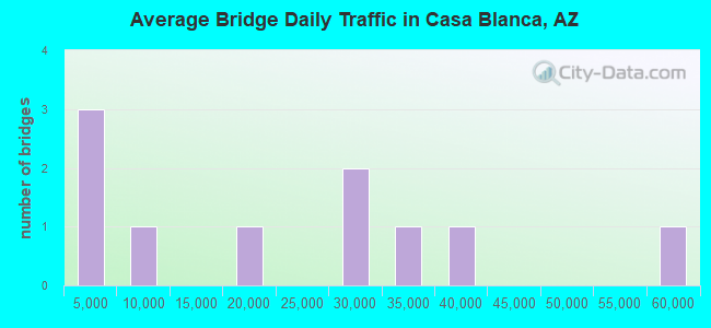
- 211,176Total average daily traffic
- 12,463Total average daily truck traffic
- National Bridge Inventory (NBI) Registered Bridges for Casa Blanca
- No street view available for this location
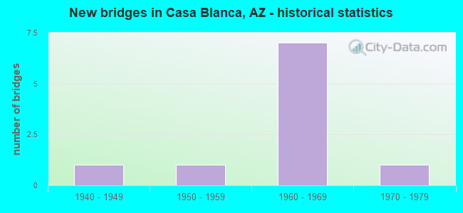
- New bridges - historical statistics
- 11940-1949
- 11950-1959
- 71960-1969
- 11970-1979
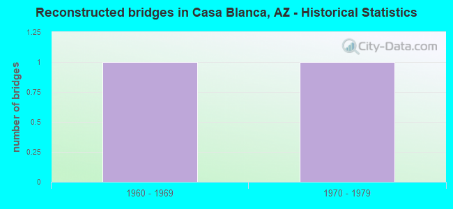
- Reconstructed bridges - Historical Statistics
- 11960-1969
- 11970-1979
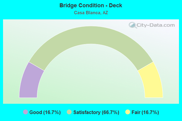
- Bridge Condition - Deck
- 16.7%Good
- 66.7%Satisfactory
- 16.7%Fair
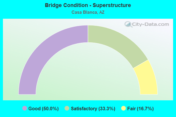
- Bridge Condition - Superstructure
- 50.0%Good
- 33.3%Satisfactory
- 16.7%Fair
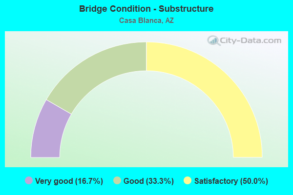
- Bridge Condition - Substructure
- 16.7%Very good
- 33.3%Good
- 50.0%Satisfactory
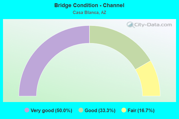
- Bridge Condition - Channel
- 50.0%Very good
- 33.3%Good
- 16.7%Fair
Find on map >> Show street view
Structure Number: 926, Location: 19.0 mi East Jct SR 95 (Lat: 34.914900, Lng: -114.152900), Route carried "on" structure: County highway , Year Built: 1966, Status: Open, Structure Length: 7.62m (25.00ft), Average Daily Traffic: 76 (year 2019), Truck Traffic: 5%, Average Future Daily Traffic: 86 (year 2039), Design Load: HS 20, Features Intersected: I 40, Facility Carried by Structure: Old Trails Road
Minimum Vertical Clearance: 30+ m (98+ ft), Kilometerpoint: 0.000, Lanes on structure: 2, Lanes under structure: 4, Owner: State Highway Agency, Approaching Roadway Width: 8.5m (27.9ft), Material/Design: Steel continuous, Design/Construction: Stringer/Multi-beam, Number Of Spans In Main Unit: 4, Length of Maximum Span: 23.8m (78.1ft), Curb or Sidewalk Widths: Left: 0.5m (1.6ft), Right: 0.5m (1.6ft), Curb-To-Curb Width: 8.5m (27.9ft), Out-to-Out Width: 10.1m (33.1ft)
Condition: Deck: Good, Superstructure: Good, Substructure: Satisfactory, Operating Rating: 52.6 metric tons, Method Used To Determine Operating Rating: Load Factor (LF), Inventory Rating: 31.8 metric tons, Method Used To Determine Inventory Rating: Load Factor (LF), Structural Evaluation: Equal to present minimum criteria, Deck Geometry: Better than present minimum criteria, Underclear: High priority of corrective action, Approach Roadway Alignment: Equal to present minimum criteria, Designated Inspection Frequency: Every 24 months, Inspection Date: June 2020, Deck Structure Type: Concrete Cast-file-Place, Wearing Surface/Protective System: Wearing Surface: Monolithic Concrete
Find on map >> Show street view
Structure Number: 1214, Location: 9.5 mi NW Jct SR 187 (Lat: 33.117500, Lng: -111.842200), Route carried "on" structure: State highway 587, Year Built: 1967, Status: Open, Structure Length: 9.08m (29.79ft), Average Daily Traffic: 6,474 (year 2019), Truck Traffic: 15%, Average Future Daily Traffic: 6,484 (year 2039), Design Load: HS 20, Features Intersected: I-10, Facility Carried by Structure: IRR Casa Blanca
Minimum Vertical Clearance: 10.67m (35.01ft), Kilometerpoint: 362.480, Lanes on structure: 2, Lanes under structure: 4, Owner: State Highway Agency, Approaching Roadway Width: 9.1m (29.9ft), Skew: 3 degrees, Material/Design: Steel continuous, Design/Construction: Stringer/Multi-beam, Number Of Spans In Main Unit: 4, Length of Maximum Span: 29.0m (95.1ft), Curb-To-Curb Width: 9.4m (30.8ft), Out-to-Out Width: 10.7m (35.1ft)
Condition: Deck: Satisfactory, Superstructure: Satisfactory, Substructure: Satisfactory, Operating Rating: 52.6 metric tons, Method Used To Determine Operating Rating: Load Factor (LF), Inventory Rating: 32.7 metric tons, Method Used To Determine Inventory Rating: Load Factor (LF), Structural Evaluation: Equal to present minimum criteria, Deck Geometry: Meets minimum limits, Underclear: High priority of corrective action, Approach Roadway Alignment: Equal to present minimum criteria, Designated Inspection Frequency: Every 24 months, Inspection Date: May 2020, Deck Structure Type: Concrete Cast-file-Place, Wearing Surface/Protective System: Wearing Surface: Monolithic Concrete
Find on map >> Show street view
Structure Number: 9158, Location: 0.2 mi W of Val Vista (Lat: 33.422750, Lng: -111.756611), Route carried "on" structure: City street , Year Built: 1959, Year Reconstructed: 1973, Status: Open, Structure Length: 1.28m (4.20ft), Average Daily Traffic: 19,720 (year 2019), Truck Traffic: 5%, Average Future Daily Traffic: 19,730 (year 2039), Design Load: HS 15, Features Intersected: Eastern Canal, Facility Carried by Structure: University Drive
Minimum Vertical Clearance: 30+ m (98+ ft), Kilometerpoint: 0.000, Lanes on structure: 5, Owner: City or Municipal Highway Agency, Approaching Roadway Width: 20.7m (67.9ft), Skew: 3 degrees, Material/Design: Concrete continuous, Design/Construction: Slab, Number Of Spans In Main Unit: 2, Length of Maximum Span: 6.1m (20.0ft), Curb or Sidewalk Widths: Left: 1.5m (4.9ft), Right: 1.5m (4.9ft), Curb-To-Curb Width: 20.7m (67.9ft), Out-to-Out Width: 24.5m (80.4ft)
Condition: Deck: Fair, Superstructure: Fair, Substructure: Very good, Channel: Very good, Operating Rating: 36.3 metric tons, Method Used To Determine Operating Rating: Load Factor (LF), Inventory Rating: 21.8 metric tons, Method Used To Determine Inventory Rating: Load Factor (LF), Structural Evaluation: Somewhat better than minimum adequacy, Deck Geometry: Somewhat better than minimum adequacy, Waterway Adequacy: Equal to present desirable criteria, Approach Roadway Alignment: Equal to present desirable criteria, Length Of Structure Improvement: 2.04m (6.69ft), Designated Inspection Frequency: Every 24 months, Underwater Inspection Frequency: Every 60 months, Inspection Date: January 2022, Underwater Inspection Date: December 2019, Total Project Cost: $1,000 ( Estimate for 2020), Deck Structure Type: Concrete Cast-file-Place, Wearing Surface/Protective System: Wearing Surface: Monolithic Concrete
Find on map >> Show street view
Structure Number: 9186, Location: 7th St S Of Jefferson St (Lat: 33.443367, Lng: -112.065372), Route carried "on" structure: City street , Year Built: 1969, Status: Open, Structure Length: 28.52m (93.57ft), Average Daily Traffic: 26,053 (year 2019), Truck Traffic: 1%, Average Future Daily Traffic: 26,063 (year 2039), Design Load: HS 20, Features Intersected: SPRR - Buchanan Street, Facility Carried by Structure: 7th Street
Minimum Vertical Clearance: 30+ m (98+ ft), Kilometerpoint: 0.000, Lanes on structure: 6, Lanes under structure: 4, Owner: City or Municipal Highway Agency, Approaching Roadway Width: 24.4m (80.1ft), Skew: 30 degrees, Material/Design: Prestressed concrete, Design/Construction: Stringer/Multi-beam, Number Of Spans In Main Unit: 10, Length of Maximum Span: 32.0m (105.0ft), Curb or Sidewalk Widths: Left: 1.5m (4.9ft), Right: 1.5m (4.9ft), Curb-To-Curb Width: 24.4m (80.1ft), Out-to-Out Width: 30.6m (100.4ft)
Condition: Deck: Satisfactory, Superstructure: Good, Substructure: Good, Operating Rating: 56.8 metric tons, Method Used To Determine Operating Rating: Load Factor (LF), Inventory Rating: 43.8 metric tons, Method Used To Determine Inventory Rating: Load Factor (LF), Structural Evaluation: Better than present minimum criteria, Deck Geometry: Somewhat better than minimum adequacy, Underclear: High priority of corrective action, Approach Roadway Alignment: Equal to present desirable criteria, Designated Inspection Frequency: Every 24 months, Inspection Date: October 2020, Deck Structure Type: Concrete Cast-file-Place, Wearing Surface/Protective System: Wearing Surface: Monolithic Concrete
Find on map >> Show street view
Structure Number: 9197, Location: 0.15 mi S of McDowell (Lat: 33.463358, Lng: -112.012933), Route carried "on" structure: City street , Year Built: 1965, Status: Open, Structure Length: 1.28m (4.20ft), Average Daily Traffic: 37,656 (year 2020), Truck Traffic: 1%, Average Future Daily Traffic: 37,666 (year 2040), Design Load: HS 15, Features Intersected: Grand Canal, Facility Carried by Structure: 32nd Street
Minimum Vertical Clearance: 30+ m (98+ ft), Kilometerpoint: 0.000, Lanes on structure: 6, Owner: City or Municipal Highway Agency, Approaching Roadway Width: 19.5m (64.0ft), Skew: 3 degrees, Material/Design: Concrete continuous, Design/Construction: Slab, Number Of Spans In Main Unit: 2, Length of Maximum Span: 6.4m (21.0ft), Curb or Sidewalk Widths: Left: 1.5m (4.9ft), Right: 1.5m (4.9ft), Curb-To-Curb Width: 19.5m (64.0ft), Out-to-Out Width: 23.3m (76.4ft)
Condition: Deck: Satisfactory, Superstructure: Satisfactory, Substructure: Satisfactory, Channel: Fair, Operating Rating: 49.6 metric tons, Method Used To Determine Operating Rating: Load Factor (LF), Inventory Rating: 29.7 metric tons, Method Used To Determine Inventory Rating: Load Factor (LF), Structural Evaluation: Equal to present minimum criteria, Deck Geometry: High priority of replacement, Waterway Adequacy: Superior to present desirable criteria, Approach Roadway Alignment: Equal to present desirable criteria, Length Of Structure Improvement: 1.28m (4.20ft), Designated Inspection Frequency: Every 24 months, Inspection Date: January 2021, Bridge Improvement Cost: $1,000, Total Project Cost: $1,000 ( Estimate for 2021), Deck Structure Type: Concrete Cast-file-Place, Wearing Surface/Protective System: Wearing Surface: Bituminous
Find on map >> Show street view
Structure Number: 9198, Location: 0.12 mi N Of Campbell Ave (Lat: 33.503953, Lng: -111.986825), Route carried "on" structure: City street , Year Built: 1967, Year Reconstructed: 1982, Status: Open, Structure Length: 2.62m (8.60ft), Average Daily Traffic: 33,789 (year 2020), Truck Traffic: 1%, Average Future Daily Traffic: 33,799 (year 2040), Design Load: HS 20, Features Intersected: Arizona Canal, Facility Carried by Structure: 44th Street
Minimum Vertical Clearance: 30+ m (98+ ft), Kilometerpoint: 0.000, Lanes on structure: 5, Owner: City or Municipal Highway Agency, Approaching Roadway Width: 20.1m (65.9ft), Skew: 5 degrees, Material/Design: Concrete continuous, Design/Construction: Slab, Number Of Spans In Main Unit: 3, Length of Maximum Span: 9.4m (30.8ft), Curb or Sidewalk Widths: Left: 1.5m (4.9ft), Right: 1.4m (4.6ft), Curb-To-Curb Width: 20.1m (65.9ft), Out-to-Out Width: 23.6m (77.4ft)
Condition: Deck: Satisfactory, Superstructure: Good, Substructure: Good, Channel: Very good, Operating Rating: 36.2 metric tons, Method Used To Determine Operating Rating: Load Factor (LF), Inventory Rating: 21.7 metric tons, Method Used To Determine Inventory Rating: Load Factor (LF), Structural Evaluation: Somewhat better than minimum adequacy, Deck Geometry: Somewhat better than minimum adequacy, Waterway Adequacy: Superior to present desirable criteria, Approach Roadway Alignment: Equal to present desirable criteria, Length Of Structure Improvement: 2.62m (8.60ft), Designated Inspection Frequency: Every 24 months, Inspection Date: January 2021, Bridge Improvement Cost: $1,000, Total Project Cost: $1,000 ( Estimate for 2021), Deck Structure Type: Concrete Cast-file-Place, Wearing Surface/Protective System: Wearing Surface: Bituminous
Find on map >> Show street view
Structure Number: 9258, Location: 0.4 mi S Jct Broadway Bl (Lat: 32.216300, Lng: -110.892300), Route carried "on" structure: City street , Year Built: 1976, Status: Open, Structure Length: 0.64m (2.10ft), Average Daily Traffic: 28,370 (year 2013), Truck Traffic: 5%, Average Future Daily Traffic: 28,380 (year 2039), Design Load: HS 20, Features Intersected: Arroyo Chico, Facility Carried by Structure: Swan Road
Minimum Vertical Clearance: 30+ m (98+ ft), Kilometerpoint: 0.000, Lanes on structure: 4, Owner: City or Municipal Highway Agency, Approaching Roadway Width: 23.2m (76.1ft), Skew: 20 degrees, Material/Design: Concrete continuous, Design/Construction: Culvert, Number Of Spans In Main Unit: 2, Length of Maximum Span: 3.0m (9.8ft), Curb or Sidewalk Widths: Left: 1.2m (3.9ft), Right: 1.2m (3.9ft), Curb-To-Curb Width: 23.2m (76.1ft), Out-to-Out Width: 30.5m (100.1ft)
Condition: Channel: Very good, Culverts: Good, Operating Rating: 52.6 metric tons, Method Used To Determine Operating Rating: Load Factor (LF), Inventory Rating: 31.8 metric tons, Method Used To Determine Inventory Rating: Load Factor (LF), Structural Evaluation: Better than present minimum criteria, Deck Geometry: Superior to present desirable criteria, Waterway Adequacy: Better than present minimum criteria, Approach Roadway Alignment: Equal to present desirable criteria, Designated Inspection Frequency: Every 48 months, Inspection Date: March 2019, Deck Structure Type: Concrete Cast-file-Place, Wearing Surface/Protective System: Wearing Surface: Bituminous
Find on map >> Show street view
Structure Number: 9259, Location: 2.4 mi S of Exit 163 (Lat: 35.229200, Lng: -112.180100), Route carried "on" structure: City street , Year Built: 1948, Status: Open, Structure Length: 0.73m (2.40ft), Average Daily Traffic: 550 (year 2021), Truck Traffic: 2%, Average Future Daily Traffic: 560 (year 2041), Design Load: HS 20, Features Intersected: Santa Fe Canyon, Facility Carried by Structure: Perkinsville Road
Minimum Vertical Clearance: 30+ m (98+ ft), Kilometerpoint: 0.000, Lanes on structure: 2, Owner: City or Municipal Highway Agency, Approaching Roadway Width: 7.3m (24.0ft), Skew: 3 degrees, Material/Design: Concrete continuous, Design/Construction: Culvert, Number Of Spans In Main Unit: 2, Length of Maximum Span: 3.0m (9.8ft), Curb or Sidewalk Widths: Left: 0.3m (1.0ft), Right: 0.3m (1.0ft), Curb-To-Curb Width: 8.9m (29.2ft), Out-to-Out Width: 9.8m (32.2ft)
Condition: Channel: Good, Culverts: Good, Operating Rating: 53.5 metric tons, Method Used To Determine Operating Rating: Load Factor (LF), Inventory Rating: 31.8 metric tons, Method Used To Determine Inventory Rating: Load Factor (LF), Structural Evaluation: Better than present minimum criteria, Deck Geometry: Somewhat better than minimum adequacy, Waterway Adequacy: Equal to present desirable criteria, Approach Roadway Alignment: Better than present minimum criteria, Designated Inspection Frequency: Every 48 months, Inspection Date: May 2021, Deck Structure Type: Concrete Cast-file-Place, Wearing Surface/Protective System: Wearing Surface: Bituminous
Find on map >> Show street view
Structure Number: 9265, Location: 4.7 mi N Jct SR 87 (Lat: 34.615900, Lng: -111.340500), Route carried "on" structure: County highway , Year Built: 1965, Status: Open, Structure Length: 0.64m (2.10ft), Average Daily Traffic: 720 (year 2018), Truck Traffic: 2%, Average Future Daily Traffic: 730 (year 2038), Design Load: HS 20, Features Intersected: Long Valley Marsh, Facility Carried by Structure: FH-3 Lake Mary Rd
Minimum Vertical Clearance: 30+ m (98+ ft), Kilometerpoint: 0.000, Lanes on structure: 2, Owner: County Highway Agency, Approaching Roadway Width: 11.0m (36.1ft), Material/Design: Concrete continuous, Design/Construction: Culvert, Number Of Spans In Main Unit: 2, Length of Maximum Span: 3.0m (9.8ft)
Condition: Channel: Good, Culverts: Good, Operating Rating: 89.8 metric tons, Method Used To Determine Operating Rating: Load Factor (LF), Inventory Rating: 89.8 metric tons, Method Used To Determine Inventory Rating: Load Factor (LF), Structural Evaluation: Better than present minimum criteria, Waterway Adequacy: Equal to present minimum criteria, Approach Roadway Alignment: Equal to present desirable criteria, Designated Inspection Frequency: Every 48 months, Inspection Date: July 2018
Find on map >> Show street view
Structure Number: 1214, Location: 9.5 mi NW Jct SR 187 (Lat: 33.117500, Lng: -111.842200), Route carried "under" structure: Interstate 10, Year Built: 1967, Structure Length: 0. m, Average Daily Traffic: 57,768 (year 2018), Truck Traffic: 14%, Features Intersected: I-10, Facility Carried by Structure: IRR Casa Blanca
Minimum Vertical Clearance: 4.94m (16.21ft), Kilometerpoint: 282.939, Lanes on structure: 2, Lanes under structure: 2, Material/Design: Steel continuous, Design/Construction: Stringer/Multi-beam, Length of Maximum Span: 29.0m (95.1ft)