Bridge Statistics for Caryville, Florida (FL)
Condition, Traffic, Stress, Structural Evaluation, Project Costs
- National Bridge Inventory (NBI) Statistics
- 20Number of bridges
- 348ft / 106mTotal length
- $258,000Total costs
- 93,746Total average daily traffic
- 28,957Total average daily truck traffic
- National Bridge Inventory (NBI) Registered Bridges for Caryville
- No street view available for this location
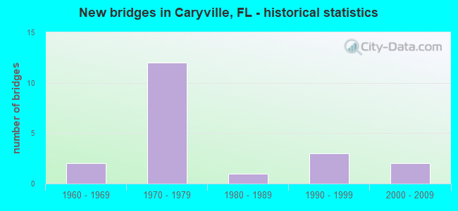
- New bridges - historical statistics
- 21960-1969
- 121970-1979
- 11980-1989
- 31990-1999
- 22000-2009


- Bridge Condition - Deck
- 66.7%Good
- 26.7%Satisfactory
- 6.7%Fair

- Bridge Condition - Superstructure
- 13.3%Very good
- 60.0%Good
- 20.0%Satisfactory
- 6.7%Fair

- Bridge Condition - Substructure
- 33.3%Good
- 40.0%Satisfactory
- 13.3%Fair
- 6.7%Poor
- 6.7%Serious

- Bridge Condition - Channel
- 14.3%Very good
- 50.0%Good
- 14.3%Satisfactory
- 14.3%Fair
- 7.1%Poor

- Bridge Condition - Culverts
- 50.0%Satisfactory
- 50.0%Poor
Find on map >> Show street view
Structure Number: 520061, Location: 2.3 Miles N of US90/SR10 (Lat: 30.807583, Lng: -85.815903), Route carried "on" structure: County highway 179, Year Built: 1960, Status: Posted for load, Structure Length: 12.82m (42.06ft), Average Daily Traffic: 1,900 (year 2020), Truck Traffic: 8%, Average Future Daily Traffic: 2,090 (year 2040), Features Intersected: Wrights Creek
Minimum Vertical Clearance: 30+ m (98+ ft), Kilometerpoint: 2.177, Lanes on structure: 2, Owner: County Highway Agency, Approaching Roadway Width: 6.4m (21.0ft), Material/Design: Concrete, Design/Construction: Slab, Number Of Spans In Main Unit: 21, Length of Maximum Span: 6.2m (20.3ft), Curb or Sidewalk Widths: Left: 0.2m (0.7ft), Right: 0.2m (0.7ft), Curb-To-Curb Width: 7.3m (24.0ft), Out-to-Out Width: 7.8m (25.6ft)
Condition: Deck: Fair, Superstructure: Fair, Substructure: Fair, Channel: Good, Operating Rating: 39.9 metric tons, Method Used To Determine Operating Rating: Load Factor (LF), Inventory Rating: 23.6 metric tons, Method Used To Determine Inventory Rating: Load Factor (LF), Structural Evaluation: Somewhat better than minimum adequacy, Deck Geometry: Meets minimum limits, Waterway Adequacy: Better than present minimum criteria, Approach Roadway Alignment: Equal to present desirable criteria, Bridge Posting: Required (Relationship of Operating Rating to Maximum Legal Load: 0.1 - 9.9% below), Designated Inspection Frequency: Every 24 months, Underwater Inspection Frequency: Every 24 months, Other Special Inspection Frequency: Every 12 months, Inspection Date: July 2020, Underwater Inspection Date: July 2020, Other Special Inspection Date: July 2021, Deck Structure Type: Concrete Cast-file-Place
Find on map >> Show street view
Structure Number: 524168, Location: 2.2 Miles East of CR179 (Lat: 30.827086, Lng: -85.809006), Route carried "on" structure: Other road , Year Built: 2009, Status: Open, Structure Length: 4.15m (13.62ft), Average Daily Traffic: 70 (year 2019), Average Future Daily Traffic: 77 (year 2039), Design Load: HS 20, Features Intersected: Wrights Creek, Facility Carried by Structure: Bonifay Gritney Rd
Minimum Vertical Clearance: 30+ m (98+ ft), Kilometerpoint: 3.465, Lanes on structure: 2, Owner: County Highway Agency, Approaching Roadway Width: 6.1m (20.0ft), Material/Design: Concrete, Design/Construction: Channel Beam, Number Of Spans In Main Unit: 4, Length of Maximum Span: 10.4m (34.1ft), Curb-To-Curb Width: 7.5m (24.6ft), Out-to-Out Width: 7.5m (24.6ft)
Condition: Deck: Satisfactory, Superstructure: Satisfactory, Substructure: Satisfactory, Channel: Good, Operating Rating: 84.4 metric tons, Method Used To Determine Operating Rating: Load Factor (LF), Inventory Rating: 50.8 metric tons, Method Used To Determine Inventory Rating: Load Factor (LF), Structural Evaluation: Equal to present minimum criteria, Deck Geometry: Equal to present minimum criteria, Waterway Adequacy: Equal to present minimum criteria, Approach Roadway Alignment: Equal to present desirable criteria, Designated Inspection Frequency: Every 24 months, Underwater Inspection Frequency: Every 24 months, Inspection Date: March 2021, Underwater Inspection Date: March 2021, Deck Structure Type: Concrete Precast Panels
Find on map >> Show street view
Structure Number: 524501, Location: 0.9 Miles East of CR179 (Lat: 30.813172, Lng: -85.801772), Route carried "on" structure: Other road , Year Built: 1972, Status: Posted for load, Structure Length: 0.68m (2.23ft), Average Daily Traffic: 91 (year 2020), Average Future Daily Traffic: 100 (year 2040), Design Load: HS 20, Features Intersected: Hathaway Mill Creek, Facility Carried by Structure: Hathaway Mill Road
Minimum Vertical Clearance: 30+ m (98+ ft), Kilometerpoint: 1.495, Lanes on structure: 1, Owner: County Highway Agency, Approaching Roadway Width: 4.3m (14.1ft), Material/Design: Wood or Timber, Design/Construction: Stringer/Multi-beam, Number Of Spans In Main Unit: 2, Length of Maximum Span: 3.5m (11.5ft), Curb-To-Curb Width: 4.9m (16.1ft), Out-to-Out Width: 4.9m (16.1ft)
Condition: Deck: Good, Superstructure: Satisfactory, Substructure: Poor, Channel: Fair, Operating Rating: 29.9 metric tons, Method Used To Determine Operating Rating: Allowable Stress (AS), Inventory Rating: 21.8 metric tons, Method Used To Determine Inventory Rating: Allowable Stress (AS), Structural Evaluation: Meets minimum limits, Deck Geometry: High priority of corrective action, Waterway Adequacy: Better than present minimum criteria, Approach Roadway Alignment: Equal to present minimum criteria, Bridge Posting: Required (Relationship of Operating Rating to Maximum Legal Load: 10.0 - 19.9% below), Designated Inspection Frequency: Every 24 months, Underwater Inspection Frequency: Every 24 months, Other Special Inspection Frequency: Every 12 months, Inspection Date: June 2020, Underwater Inspection Date: June 2020, Other Special Inspection Date: June 2021, Deck Structure Type: Wood or Timber, Wearing Surface/Protective System: Wearing Surface: Wood or Timber
Find on map >> Show street view
Structure Number: 610042, Location: 0.5Mi East of CR279 (Lat: 30.759139, Lng: -85.805000), Route carried "on" structure: Interstate 10, Year Built: 1973, Year Reconstructed: 1994, Status: Open, Structure Length: 9.14m (29.99ft), Average Daily Traffic: 9,350 (year 2020), Truck Traffic: 37%, Average Future Daily Traffic: 16,222 (year 2042), Design Load: HS 20+Mod, Features Intersected: Cypress Slough
Minimum Vertical Clearance: 30+ m (98+ ft), Kilometerpoint: 2.688, Lanes on structure: 2, Base Highway Network: Yes, Owner: State Highway Agency, Approaching Roadway Width: 11.6m (38.1ft), Material/Design: Prestressed concrete, Design/Construction: Stringer/Multi-beam, Number Of Spans In Main Unit: 6, Length of Maximum Span: 15.2m (49.9ft), Curb-To-Curb Width: 12.2m (40.0ft), Out-to-Out Width: 13.1m (43.0ft)
Condition: Deck: Good, Superstructure: Good, Substructure: Satisfactory, Channel: Good, Operating Rating: 81.6 metric tons, Method Used To Determine Operating Rating: Load Factor (LF), Inventory Rating: 49.0 metric tons, Method Used To Determine Inventory Rating: Load Factor (LF), Structural Evaluation: Equal to present minimum criteria, Deck Geometry: Better than present minimum criteria, Waterway Adequacy: Equal to present desirable criteria, Approach Roadway Alignment: Equal to present desirable criteria, Designated Inspection Frequency: Every 24 months, Underwater Inspection Frequency: Every 24 months, Inspection Date: June 2021, Underwater Inspection Date: June 2021, Deck Structure Type: Concrete Cast-file-Place
Find on map >> Show street view
Structure Number: 610045, Location: 1.0mi E of Choctaw. River (Lat: 30.758042, Lng: -85.812692), Route carried "on" structure: Interstate 10, Year Built: 1973, Status: Open, Structure Length: 5.50m (18.04ft), Average Daily Traffic: 9,350 (year 2020), Truck Traffic: 37%, Average Future Daily Traffic: 16,222 (year 2042), Design Load: HS 20, Features Intersected: CR279 Pate Pond Road
Minimum Vertical Clearance: 30+ m (98+ ft), Kilometerpoint: 1.915, Lanes on structure: 2, Lanes under structure: 2, Base Highway Network: Yes, Owner: State Highway Agency, Approaching Roadway Width: 11.6m (38.1ft), Material/Design: Prestressed concrete, Design/Construction: Stringer/Multi-beam, Number Of Spans In Main Unit: 2, Length of Maximum Span: 27.5m (90.2ft), Curb-To-Curb Width: 12.2m (40.0ft), Out-to-Out Width: 13.1m (43.0ft)
Condition: Deck: Good, Superstructure: Good, Substructure: Good, Inventory Rating: 66.2 metric tons, Method Used To Determine Inventory Rating: Load Factor (LF), Structural Evaluation: Better than present minimum criteria, Deck Geometry: Better than present minimum criteria, Underclear: Better than present minimum criteria, Approach Roadway Alignment: Equal to present desirable criteria, Designated Inspection Frequency: Every 24 months, Inspection Date: January 2021, Deck Structure Type: Concrete Cast-file-Place
Find on map >> Show street view
Structure Number: 610049, Location: 0.4 Miles West of CR279 (Lat: 30.757267, Lng: -85.819639), Route carried "on" structure: Interstate 10, Year Built: 1973, Status: Open, Structure Length: 13.18m (43.24ft), Average Daily Traffic: 10,250 (year 2020), Truck Traffic: 33%, Average Future Daily Traffic: 17,784 (year 2042), Design Load: HS 20+Mod, Features Intersected: E Choctaw River Relief
Minimum Vertical Clearance: 30+ m (98+ ft), Kilometerpoint: 1.212, Lanes on structure: 2, Base Highway Network: Yes, Owner: State Highway Agency, Approaching Roadway Width: 11.6m (38.1ft), Material/Design: Prestressed concrete, Design/Construction: Stringer/Multi-beam, Number Of Spans In Main Unit: 7, Length of Maximum Span: 18.8m (61.7ft), Curb-To-Curb Width: 12.2m (40.0ft), Out-to-Out Width: 13.1m (43.0ft)
Condition: Deck: Satisfactory, Superstructure: Good, Substructure: Satisfactory, Channel: Very good, Operating Rating: 83.5 metric tons, Method Used To Determine Operating Rating: Load Factor (LF), Inventory Rating: 49.9 metric tons, Method Used To Determine Inventory Rating: Load Factor (LF), Structural Evaluation: Equal to present minimum criteria, Deck Geometry: Better than present minimum criteria, Waterway Adequacy: Equal to present desirable criteria, Approach Roadway Alignment: Equal to present desirable criteria, Designated Inspection Frequency: Every 24 months, Underwater Inspection Frequency: Every 24 months, Inspection Date: July 2021, Underwater Inspection Date: July 2021, Deck Structure Type: Concrete Cast-file-Place
Find on map >> Show street view
Structure Number: 61005, Location: 1.0mi E of Choctaw. River (Lat: 30.758283, Lng: -85.812733), Route carried "on" structure: Interstate 10, Year Built: 1973, Status: Open, Structure Length: 5.50m (18.04ft), Average Daily Traffic: 9,350 (year 2020), Truck Traffic: 37%, Average Future Daily Traffic: 16,222 (year 2042), Design Load: HS 20, Features Intersected: CR279 Pate Pond Road
Minimum Vertical Clearance: 30+ m (98+ ft), Kilometerpoint: 1.915, Lanes on structure: 2, Lanes under structure: 2, Base Highway Network: Yes, Owner: State Highway Agency, Approaching Roadway Width: 11.6m (38.1ft), Material/Design: Prestressed concrete, Design/Construction: Stringer/Multi-beam, Number Of Spans In Main Unit: 2, Length of Maximum Span: 27.5m (90.2ft), Curb-To-Curb Width: 12.2m (40.0ft), Out-to-Out Width: 13.1m (43.0ft)
Condition: Deck: Good, Superstructure: Very good, Substructure: Good, Inventory Rating: 66.2 metric tons, Method Used To Determine Inventory Rating: Load Factor (LF), Structural Evaluation: Better than present minimum criteria, Deck Geometry: Better than present minimum criteria, Underclear: Better than present minimum criteria, Approach Roadway Alignment: Equal to present desirable criteria, Designated Inspection Frequency: Every 24 months, Inspection Date: January 2021, Deck Structure Type: Concrete Cast-file-Place
Find on map >> Show street view
Structure Number: 610053, Location: 6.7Mi West of SR79 (Lat: 30.760164, Lng: -85.798619), Route carried "on" structure: County highway , Year Built: 1973, Status: Open, Structure Length: 7.18m (23.56ft), Average Daily Traffic: 85 (year 2015), Truck Traffic: 1%, Average Future Daily Traffic: 151 (year 2035), Design Load: HS 20, Features Intersected: I10 SR8, Facility Carried by Structure: St. Mary's Road
Minimum Vertical Clearance: 30+ m (98+ ft), Kilometerpoint: 6.790, Lanes on structure: 2, Lanes under structure: 4, Owner: State Highway Agency, Approaching Roadway Width: 7.3m (24.0ft), Material/Design: Prestressed concrete, Design/Construction: Stringer/Multi-beam, Number Of Spans In Main Unit: 4, Length of Maximum Span: 26.8m (87.9ft), Curb-To-Curb Width: 9.8m (32.2ft), Out-to-Out Width: 10.4m (34.1ft)
Condition: Deck: Good, Superstructure: Good, Substructure: Good, Operating Rating: 70.8 metric tons, Method Used To Determine Operating Rating: Load Factor (LF), Inventory Rating: 41.7 metric tons, Method Used To Determine Inventory Rating: Load Factor (LF), Structural Evaluation: Better than present minimum criteria, Deck Geometry: Equal to present desirable criteria, Underclear: Equal to present minimum criteria, Approach Roadway Alignment: Equal to present desirable criteria, Designated Inspection Frequency: Every 24 months, Inspection Date: March 2020, Deck Structure Type: Concrete Cast-file-Place
Find on map >> Show street view
Structure Number: 610056, Location: 1.3MI. East of CR179 (Lat: 30.780000, Lng: -85.783056), Route carried "on" structure: US 90, Year Built: 1960, Status: Open, Structure Length: 0.63m (2.07ft), Average Daily Traffic: 3,200 (year 2020), Truck Traffic: 10%, Average Future Daily Traffic: 5,552 (year 2042), Design Load: H 15, Features Intersected: Little Dram Branch
Minimum Vertical Clearance: 30+ m (98+ ft), Kilometerpoint: 4.892, Lanes on structure: 2, Base Highway Network: Yes, Owner: State Highway Agency, Approaching Roadway Width: 10.4m (34.1ft), Material/Design: Concrete, Design/Construction: Culvert, Number Of Spans In Main Unit: 2, Length of Maximum Span: 3.0m (9.8ft)
Condition: Channel: Good, Culverts: Satisfactory, Operating Rating: 78.0 metric tons, Method Used To Determine Operating Rating: Load Factor (LF), Inventory Rating: 46.3 metric tons, Method Used To Determine Inventory Rating: Load Factor (LF), Structural Evaluation: Equal to present minimum criteria, Waterway Adequacy: Equal to present desirable criteria, Approach Roadway Alignment: Equal to present desirable criteria, Designated Inspection Frequency: Every 24 months, Inspection Date: May 2021
Find on map >> Show street view
Structure Number: 610063, Location: 0.4 Miles W. of CR279 (Lat: 30.757033, Lng: -85.819561), Route carried "on" structure: Interstate 10, Year Built: 1973, Status: Open, Structure Length: 13.17m (43.21ft), Average Daily Traffic: 10,250 (year 2020), Truck Traffic: 33%, Average Future Daily Traffic: 17,784 (year 2042), Design Load: HS 20+Mod, Features Intersected: E Choctaw River Relief
Minimum Vertical Clearance: 30+ m (98+ ft), Kilometerpoint: 1.212, Lanes on structure: 2, Base Highway Network: Yes, Owner: State Highway Agency, Approaching Roadway Width: 11.6m (38.1ft), Material/Design: Prestressed concrete, Design/Construction: Stringer/Multi-beam, Number Of Spans In Main Unit: 7, Length of Maximum Span: 18.8m (61.7ft), Curb-To-Curb Width: 12.2m (40.0ft), Out-to-Out Width: 13.1m (43.0ft)
Condition: Deck: Satisfactory, Superstructure: Good, Substructure: Satisfactory, Channel: Very good, Operating Rating: 83.5 metric tons, Method Used To Determine Operating Rating: Load Factor (LF), Inventory Rating: 49.9 metric tons, Method Used To Determine Inventory Rating: Load Factor (LF), Structural Evaluation: Equal to present minimum criteria, Deck Geometry: Better than present minimum criteria, Waterway Adequacy: Equal to present desirable criteria, Approach Roadway Alignment: Equal to present desirable criteria, Designated Inspection Frequency: Every 24 months, Underwater Inspection Frequency: Every 24 months, Inspection Date: July 2021, Underwater Inspection Date: July 2021, Deck Structure Type: Concrete Cast-file-Place
Find on map >> Show street view
Structure Number: 610066, Location: 0.82 Mi S of I10 (Lat: 30.747478, Lng: -85.807553), Route carried "on" structure: County highway 279, Year Built: 1976, Status: Posted for load-capacity, Structure Length: 3.41m (11.19ft), Average Daily Traffic: 1,600 (year 2021), Truck Traffic: 8%, Average Future Daily Traffic: 2,776 (year 2042), Features Intersected: Dram Branch
Minimum Vertical Clearance: 30+ m (98+ ft), Kilometerpoint: 16.266, Lanes on structure: 2, Owner: County Highway Agency, Approaching Roadway Width: 6.7m (22.0ft), Material/Design: Concrete continuous, Design/Construction: Slab, Number Of Spans In Main Unit: 4, Length of Maximum Span: 9.2m (30.2ft), Curb-To-Curb Width: 9.1m (29.9ft), Out-to-Out Width: 10.0m (32.8ft)
Condition: Deck: Satisfactory, Superstructure: Satisfactory, Substructure: Satisfactory, Channel: Fair, Inventory Rating: 67.9 metric tons, Method Used To Determine Inventory Rating: Load Factor (LF), Structural Evaluation: Equal to present minimum criteria, Deck Geometry: Somewhat better than minimum adequacy, Waterway Adequacy: Better than present minimum criteria, Approach Roadway Alignment: Equal to present minimum criteria, Designated Inspection Frequency: Every 24 months, Underwater Inspection Frequency: Every 12 months, Other Special Inspection Frequency: Every 12 months, Inspection Date: March 2021, Underwater Inspection Date: March 2021, Other Special Inspection Date: March 2021, Deck Structure Type: Concrete Cast-file-Place
Find on map >> Show street view
Structure Number: 61009, Location: 1.36Mi North of CR 280 (Lat: 30.721214, Lng: -85.778536), Route carried "on" structure: County highway 279, Year Built: 1999, Status: Open, Structure Length: 5.18m (16.99ft), Average Daily Traffic: 1,200 (year 2020), Truck Traffic: 7%, Average Future Daily Traffic: 2,082 (year 2042), Features Intersected: Gum Creek
Minimum Vertical Clearance: 30+ m (98+ ft), Kilometerpoint: 12.176, Lanes on structure: 2, Owner: County Highway Agency, Approaching Roadway Width: 6.7m (22.0ft), Material/Design: Prestressed concrete, Design/Construction: Stringer/Multi-beam, Number Of Spans In Main Unit: 4, Length of Maximum Span: 13.0m (42.7ft), Curb-To-Curb Width: 12.2m (40.0ft), Out-to-Out Width: 13.2m (43.3ft)
Condition: Deck: Good, Superstructure: Good, Substructure: Good, Channel: Satisfactory, Operating Rating: 62.1 metric tons, Method Used To Determine Operating Rating: Load Factor (LF), Inventory Rating: 20.7 metric tons, Method Used To Determine Inventory Rating: Load Factor (LF), Structural Evaluation: Somewhat better than minimum adequacy, Deck Geometry: Better than present minimum criteria, Waterway Adequacy: Better than present minimum criteria, Approach Roadway Alignment: Equal to present desirable criteria, Designated Inspection Frequency: Every 24 months, Inspection Date: November 2020, Deck Structure Type: Concrete Cast-file-Place
Find on map >> Show street view
Structure Number: 610091, Location: 1.3 Miles E.of Countyline (Lat: 30.774497, Lng: -85.810825), Route carried "on" structure: US 90, Year Built: 2001, Status: Open, Structure Length: 14.40m (47.24ft), Average Daily Traffic: 3,200 (year 2020), Truck Traffic: 10%, Average Future Daily Traffic: 5,552 (year 2042), Design Load: HS 20+Mod, Features Intersected: Cypress Slough
Minimum Vertical Clearance: 30+ m (98+ ft), Kilometerpoint: 2.107, Lanes on structure: 2, Base Highway Network: Yes, Owner: State Highway Agency, Approaching Roadway Width: 9.8m (32.2ft), Material/Design: Prestressed concrete, Design/Construction: Stringer/Multi-beam, Number Of Spans In Main Unit: 5, Length of Maximum Span: 28.8m (94.5ft), Curb-To-Curb Width: 13.1m (43.0ft), Out-to-Out Width: 14.1m (46.3ft)
Condition: Deck: Good, Superstructure: Very good, Substructure: Good, Channel: Good, Inventory Rating: 54.4 metric tons, Method Used To Determine Inventory Rating: Load Factor (LF), Structural Evaluation: Better than present minimum criteria, Deck Geometry: Equal to present minimum criteria, Waterway Adequacy: Equal to present desirable criteria, Approach Roadway Alignment: Equal to present desirable criteria, Designated Inspection Frequency: Every 24 months, Inspection Date: November 2020, Deck Structure Type: Concrete Cast-file-Place
Find on map >> Show street view
Structure Number: 610951, Location: 0.5 mi. East of CR279 (Lat: 30.759469, Lng: -85.805056), Route carried "on" structure: Interstate 10, Year Built: 1973, Year Reconstructed: 1994, Status: Open, Structure Length: 9.14m (29.99ft), Average Daily Traffic: 9,350 (year 2020), Truck Traffic: 37%, Average Future Daily Traffic: 16,222 (year 2042), Design Load: HS 20+Mod, Features Intersected: Cypress Slough
Minimum Vertical Clearance: 30+ m (98+ ft), Kilometerpoint: 2.688, Lanes on structure: 2, Base Highway Network: Yes, Owner: State Highway Agency, Approaching Roadway Width: 11.6m (38.1ft), Material/Design: Prestressed concrete, Design/Construction: Stringer/Multi-beam, Number Of Spans In Main Unit: 6, Length of Maximum Span: 15.2m (49.9ft), Curb-To-Curb Width: 12.2m (40.0ft), Out-to-Out Width: 13.1m (43.0ft)
Condition: Deck: Good, Superstructure: Good, Substructure: Satisfactory, Channel: Good, Operating Rating: 81.6 metric tons, Method Used To Determine Operating Rating: Load Factor (LF), Inventory Rating: 49.0 metric tons, Method Used To Determine Inventory Rating: Load Factor (LF), Structural Evaluation: Equal to present minimum criteria, Deck Geometry: Better than present minimum criteria, Waterway Adequacy: Equal to present desirable criteria, Approach Roadway Alignment: Equal to present desirable criteria, Designated Inspection Frequency: Every 24 months, Underwater Inspection Frequency: Every 24 months, Inspection Date: June 2021, Underwater Inspection Date: June 2021, Deck Structure Type: Concrete Cast-file-Place
Find on map >> Show street view
Structure Number: 614088, Location: 0.1 Mi S of Clovis Rd (Lat: 30.768294, Lng: -85.801578), Route carried "on" structure: County highway , Year Built: 1993, Status: Open, Structure Length: 0.73m (2.40ft), Average Daily Traffic: 100 (year 2021), Average Future Daily Traffic: 174 (year 2042), Features Intersected: Little Dram Branch, Facility Carried by Structure: St Mary's Road
Minimum Vertical Clearance: 30+ m (98+ ft), Kilometerpoint: 7.781, Lanes on structure: 2, Owner: County Highway Agency, Approaching Roadway Width: 6.7m (22.0ft), Material/Design: Concrete, Design/Construction: Channel Beam, Number Of Spans In Main Unit: 1, Length of Maximum Span: 7.3m (24.0ft), Curb-To-Curb Width: 8.6m (28.2ft), Out-to-Out Width: 9.5m (31.2ft)
Condition: Deck: Good, Superstructure: Good, Substructure: Serious, Channel: Satisfactory, Inventory Rating: 60.1 metric tons, Method Used To Determine Inventory Rating: Load Factor (LF), Structural Evaluation: High priority of corrective action, Deck Geometry: Better than present minimum criteria, Waterway Adequacy: Equal to present desirable criteria, Approach Roadway Alignment: Equal to present minimum criteria, Designated Inspection Frequency: Every 24 months, Underwater Inspection Frequency: Every 6 months, Other Special Inspection Frequency: Every 6 months, Inspection Date: September 2021, Underwater Inspection Date: September 2021, Other Special Inspection Date: September 2021, Deck Structure Type: Concrete Precast Panels
Find on map >> Show street view
Structure Number: 614089, Location: 0.57 Mi N of Harcus Rd (Lat: 30.753886, Lng: -85.782294), Route carried "on" structure: County highway , Year Built: 1993, Status: Open, Structure Length: 0.73m (2.40ft), Average Daily Traffic: 100 (year 2021), Average Future Daily Traffic: 174 (year 2042), Features Intersected: Dram Branch, Facility Carried by Structure: St Mary's Road
Minimum Vertical Clearance: 30+ m (98+ ft), Kilometerpoint: 4.937, Lanes on structure: 2, Owner: County Highway Agency, Approaching Roadway Width: 6.7m (22.0ft), Material/Design: Concrete, Design/Construction: Channel Beam, Number Of Spans In Main Unit: 1, Length of Maximum Span: 7.3m (24.0ft), Curb-To-Curb Width: 8.6m (28.2ft), Out-to-Out Width: 9.5m (31.2ft)
Condition: Deck: Good, Superstructure: Good, Substructure: Fair, Channel: Poor, Inventory Rating: 60.1 metric tons, Method Used To Determine Inventory Rating: Load Factor (LF), Structural Evaluation: Somewhat better than minimum adequacy, Deck Geometry: Better than present minimum criteria, Waterway Adequacy: Better than present minimum criteria, Approach Roadway Alignment: Equal to present minimum criteria, Designated Inspection Frequency: Every 24 months, Underwater Inspection Frequency: Every 12 months, Other Special Inspection Frequency: Every 12 months, Inspection Date: September 2021, Underwater Inspection Date: September 2021, Other Special Inspection Date: September 2021, Deck Structure Type: Concrete Precast Panels
Find on map >> Show street view
Structure Number: 614127, Location: 1.15 Mi South of I 10 (Lat: 30.743678, Lng: -85.804300), Route carried "on" structure: County highway 279, Year Built: 1986, Status: Open, Structure Length: 0.63m (2.07ft), Average Daily Traffic: 1,400 (year 2019), Truck Traffic: 7%, Average Future Daily Traffic: 2,429 (year 2041), Features Intersected: Dram Branch
Minimum Vertical Clearance: 30+ m (98+ ft), Kilometerpoint: 15.718, Lanes on structure: 2, Owner: County Highway Agency, Approaching Roadway Width: 6.7m (22.0ft), Material/Design: Concrete, Design/Construction: Culvert, Number Of Spans In Main Unit: 2, Length of Maximum Span: 3.1m (10.2ft)
Condition: Channel: Good, Culverts: Poor, Operating Rating: 44.7 metric tons, Method Used To Determine Operating Rating: Load and Resistance Factor (LRFR), Inventory Rating: 34.7 metric tons, Method Used To Determine Inventory Rating: Load and Resistance Factor (LRFR), Structural Evaluation: Meets minimum limits, Waterway Adequacy: Better than present minimum criteria, Approach Roadway Alignment: Equal to present desirable criteria, Length Of Structure Improvement: 0.69m (2.26ft), Designated Inspection Frequency: Every 24 months, Underwater Inspection Frequency: Every 12 months, Other Special Inspection Frequency: Every 12 months, Inspection Date: May 2020, Underwater Inspection Date: May 2021, Other Special Inspection Date: May 2021, Total Project Cost: $258,000
Find on map >> Show street view
Structure Number: 610045, Location: 1.0mi E of Choctaw. River (Lat: 30.758042, Lng: -85.812692), Route carried "under" structure: County highway 279, Year Built: 1973, Structure Length: 0. m, Average Daily Traffic: 2,100 (year 2020), Truck Traffic: 8%, Features Intersected: CR279 Pate Pond Road, Facility Carried by Structure: I10 SR8
Minimum Vertical Clearance: 5.15m (16.90ft), Kilometerpoint: 17.687, Lanes on structure: 2, Lanes under structure: 2, Material/Design: Prestressed concrete, Design/Construction: Stringer/Multi-beam, Length of Maximum Span: 27.5m (90.2ft)
Find on map >> Show street view
Structure Number: 61005, Location: 1.0mi E of Choctaw. River (Lat: 30.758283, Lng: -85.812733), Route carried "under" structure: County highway 279, Year Built: 1973, Structure Length: 0. m, Average Daily Traffic: 2,100 (year 2020), Truck Traffic: 8%, Features Intersected: CR279 Pate Pond Road, Facility Carried by Structure: I10 SR8
Minimum Vertical Clearance: 5.12m (16.80ft), Kilometerpoint: 17.703, Lanes on structure: 2, Lanes under structure: 2, Material/Design: Prestressed concrete, Design/Construction: Stringer/Multi-beam, Length of Maximum Span: 27.5m (90.2ft)
Find on map >> Show street view
Structure Number: 610053, Location: 6.7Mi West of SR79 (Lat: 30.760164, Lng: -85.798619), Route carried "under" structure: Interstate 10, Year Built: 1973, Structure Length: 0. m, Average Daily Traffic: 18,700 (year 2020), Truck Traffic: 37%, Features Intersected: I10 SR8, Facility Carried by Structure: St. Mary's Road
Minimum Vertical Clearance: 5.03m (16.50ft), Kilometerpoint: 3.307, Lanes on structure: 2, Lanes under structure: 4, Material/Design: Prestressed concrete, Design/Construction: Stringer/Multi-beam, Length of Maximum Span: 26.8m (87.9ft)