Bridge Statistics for Carson City, Nevada (NV)
Condition, Traffic, Stress, Structural Evaluation, Project Costs
- National Bridge Inventory (NBI) Statistics
- 51Number of bridges
- 620ft / 189mTotal length
- 555,680Total average daily traffic
- 27,913Total average daily truck traffic
- National Bridge Inventory (NBI) Registered Bridges for Carson City
- No street view available for this location
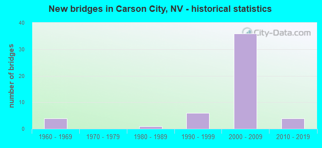
- New bridges - historical statistics
- 41960-1969
- 11980-1989
- 61990-1999
- 362000-2009
- 42010-2019


- Bridge Condition - Deck
- 28.0%Very good
- 60.0%Good
- 12.0%Satisfactory

- Bridge Condition - Superstructure
- 34.6%Very good
- 57.7%Good
- 7.7%Satisfactory

- Bridge Condition - Substructure
- 30.8%Very good
- 65.4%Good
- 3.8%Satisfactory

- Bridge Condition - Channel
- 33.3%Very good
- 50.0%Good
- 16.7%Satisfactory

- Bridge Condition - Culverts
- 71.4%Good
- 28.6%Satisfactory
Find on map >> Show street view
Structure Number: B1274, Location: SE CARSON CITY (Lat: 39.181219, Lng: -119.695808), Route carried "on" structure: City street 513, Year Built: 2005, Status: Open, Structure Length: 9.44m (30.97ft), Average Daily Traffic: 1,950 (year 2017), Truck Traffic: 3%, Average Future Daily Traffic: 3,000 (year 2040), Design Load: HS 20+Mod, Features Intersected: CARSON RVR
Minimum Vertical Clearance: 30+ m (98+ ft), Kilometerpoint: 12.352, Lanes on structure: 2, Owner: City or Municipal Highway Agency, Approaching Roadway Width: 10.9m (35.8ft), Material/Design: Prestressed concrete continuous, Design/Construction: Stringer/Multi-beam, Number Of Spans In Main Unit: 3, Length of Maximum Span: 36.5m (119.8ft), Curb-To-Curb Width: 10.9m (35.8ft), Out-to-Out Width: 11.8m (38.7ft)
Condition: Deck: Good, Superstructure: Good, Substructure: Good, Channel: Good, Operating Rating: 75.1 metric tons, Method Used To Determine Operating Rating: Load Factor (LF), Inventory Rating: 45.0 metric tons, Method Used To Determine Inventory Rating: Load Factor (LF), Structural Evaluation: Better than present minimum criteria, Deck Geometry: Equal to present minimum criteria, Waterway Adequacy: Superior to present desirable criteria, Approach Roadway Alignment: Equal to present desirable criteria, Designated Inspection Frequency: Every 24 months, Underwater Inspection Frequency: Every 48 months, Inspection Date: April 2021, Underwater Inspection Date: August 2019, Deck Structure Type: Concrete Cast-file-Place, Wearing Surface/Protective System: Wearing Surface: Monolithic Concrete, Deck Protection: Epoxy Coated Reinforcing
Find on map >> Show street view
Structure Number: B1328, Location: CARSON CITY (Lat: 39.142250, Lng: -119.705514), Route carried "on" structure: City street 528, Year Built: 1990, Status: Open, Structure Length: 7.99m (26.21ft), Average Daily Traffic: 820 (year 2017), Truck Traffic: 3%, Average Future Daily Traffic: 1,000 (year 2040), Design Load: HS 20+Mod, Features Intersected: CARSON RVR, Facility Carried by Structure: SR 513CARSON RV RD
Minimum Vertical Clearance: 30+ m (98+ ft), Kilometerpoint: 7.479, Lanes on structure: 2, Owner: City or Municipal Highway Agency, Approaching Roadway Width: 9.8m (32.2ft), Skew: 4 degrees, Material/Design: Steel continuous, Design/Construction: Stringer/Multi-beam, Number Of Spans In Main Unit: 3, Length of Maximum Span: 27.4m (89.9ft), Curb-To-Curb Width: 12.6m (41.3ft), Out-to-Out Width: 13.6m (44.6ft)
Condition: Deck: Satisfactory, Superstructure: Good, Substructure: Good, Channel: Good, Inventory Rating: 56.8 metric tons, Method Used To Determine Inventory Rating: Load Factor (LF), Structural Evaluation: Better than present minimum criteria, Deck Geometry: Superior to present desirable criteria, Waterway Adequacy: Equal to present desirable criteria, Approach Roadway Alignment: Equal to present desirable criteria, Designated Inspection Frequency: Every 24 months, Underwater Inspection Frequency: Every 48 months, Inspection Date: April 2021, Underwater Inspection Date: August 2019, Deck Structure Type: Concrete Cast-file-Place, Wearing Surface/Protective System: Wearing Surface: Monolithic Concrete, Deck Protection: Epoxy Coated Reinforcing
Find on map >> Show street view
Structure Number: B2291N, Location: EAST OF CARSON CITY (Lat: 39.162947, Lng: -119.739753), Route carried "on" structure: US 395, Year Built: 2009, Status: Open, Structure Length: 12.37m (40.58ft), Average Daily Traffic: 16,500 (year 2017), Truck Traffic: 3%, Average Future Daily Traffic: 40,951 (year 2040), Design Load: HS 20+Mod, Features Intersected: KINGS CANYON CHANNEL
Minimum Vertical Clearance: 30+ m (98+ ft), Kilometerpoint: 0.000, Lanes on structure: 2, Base Highway Network: Yes, Owner: State Highway Agency, Approaching Roadway Width: 12.8m (42.0ft), Material/Design: Prestressed concrete continuous, Design/Construction: Slab, Number Of Spans In Main Unit: 7, Length of Maximum Span: 14.6m (47.9ft), Curb-To-Curb Width: 12.8m (42.0ft), Out-to-Out Width: 13.7m (44.9ft)
Condition: Deck: Good, Superstructure: Good, Substructure: Very good, Channel: Very good, Operating Rating: 55.8 metric tons, Method Used To Determine Operating Rating: Load and Resistance Factor (LRFR), Inventory Rating: 43.1 metric tons, Method Used To Determine Inventory Rating: Load and Resistance Factor (LRFR), Structural Evaluation: Better than present minimum criteria, Deck Geometry: Equal to present desirable criteria, Waterway Adequacy: Equal to present desirable criteria, Approach Roadway Alignment: Equal to present desirable criteria, Designated Inspection Frequency: Every 48 months, Inspection Date: June 2021, Deck Structure Type: Concrete Cast-file-Place, Wearing Surface/Protective System: Wearing Surface: Epoxy Overlay, Deck Protection: Epoxy Coated Reinforcing
Find on map >> Show street view
Structure Number: B2291S, Location: EAST OF CARSON CITY (Lat: 39.163033, Lng: -119.739931), Route carried "on" structure: US 395, Year Built: 2009, Status: Open, Structure Length: 12.37m (40.58ft), Average Daily Traffic: 16,500 (year 2017), Truck Traffic: 3%, Average Future Daily Traffic: 40,951 (year 2040), Design Load: HS 20+Mod, Features Intersected: KINGS CANYON CHANNEL
Minimum Vertical Clearance: 30+ m (98+ ft), Kilometerpoint: 0.000, Lanes on structure: 2, Base Highway Network: Yes, Owner: State Highway Agency, Approaching Roadway Width: 12.8m (42.0ft), Material/Design: Prestressed concrete continuous, Design/Construction: Slab, Number Of Spans In Main Unit: 7, Length of Maximum Span: 14.6m (47.9ft), Curb-To-Curb Width: 12.8m (42.0ft), Out-to-Out Width: 13.7m (44.9ft)
Condition: Deck: Good, Superstructure: Good, Substructure: Very good, Channel: Very good, Operating Rating: 55.8 metric tons, Method Used To Determine Operating Rating: Load and Resistance Factor (LRFR), Inventory Rating: 43.1 metric tons, Method Used To Determine Inventory Rating: Load and Resistance Factor (LRFR), Structural Evaluation: Better than present minimum criteria, Deck Geometry: Equal to present desirable criteria, Waterway Adequacy: Equal to present desirable criteria, Approach Roadway Alignment: Equal to present desirable criteria, Designated Inspection Frequency: Every 48 months, Inspection Date: June 2021, Deck Structure Type: Concrete Cast-file-Place, Wearing Surface/Protective System: Wearing Surface: Epoxy Overlay, Deck Protection: Epoxy Coated Reinforcing
Find on map >> Show street view
Structure Number: B2301, Location: CARSON CITY (Lat: 39.190586, Lng: -119.773483), Route carried "on" structure: City street , Year Built: 1996, Status: Open, Structure Length: 0.82m (2.69ft), Average Daily Traffic: 4,500 (year 2017), Truck Traffic: 5%, Average Future Daily Traffic: 11,169 (year 2040), Design Load: HS 20+Mod, Features Intersected: DRY WASH, Facility Carried by Structure: COLLEGE PW
Minimum Vertical Clearance: 30+ m (98+ ft), Kilometerpoint: 0.000, Lanes on structure: 6, Owner: State Highway Agency, Approaching Roadway Width: 19.2m (63.0ft), Skew: 20 degrees, Material/Design: Concrete, Design/Construction: Culvert, Number Of Spans In Main Unit: 3, Length of Maximum Span: 2.4m (7.9ft), Curb or Sidewalk Widths: Left: 2.7m (8.9ft), Right: 2.1m (6.9ft)
Condition: Channel: Good, Culverts: Satisfactory, Operating Rating: 70.5 metric tons, Method Used To Determine Operating Rating: Load Factor (LF), Inventory Rating: 42.1 metric tons, Method Used To Determine Inventory Rating: Load Factor (LF), Structural Evaluation: Equal to present minimum criteria, Waterway Adequacy: Better than present minimum criteria, Approach Roadway Alignment: Equal to present desirable criteria, Designated Inspection Frequency: Every 48 months, Inspection Date: April 2021, Deck Structure Type: Concrete Cast-file-Place, Wearing Surface/Protective System: Wearing Surface: Monolithic Concrete
Find on map >> Show street view
Structure Number: B2625, Location: CARSON CITY (Lat: 39.163636, Lng: -119.732794), Route carried "on" structure: City street , Year Built: 1995, Status: Open, Structure Length: 1.28m (4.20ft), Average Daily Traffic: 2,900 (year 2017), Truck Traffic: 2%, Average Future Daily Traffic: 3,500 (year 2040), Design Load: HS 20, Features Intersected: DRAINAGE, Facility Carried by Structure: BUTTI WY
Minimum Vertical Clearance: 30+ m (98+ ft), Kilometerpoint: 0.000, Lanes on structure: 2, Owner: City or Municipal Highway Agency, Approaching Roadway Width: 8.7m (28.5ft), Material/Design: Concrete, Design/Construction: Culvert, Number Of Spans In Main Unit: 4, Length of Maximum Span: 3.0m (9.8ft), Curb or Sidewalk Widths: Left: 0.0m, Right: 0.2m (0.7ft), Curb-To-Curb Width: 12.0m (39.4ft), Out-to-Out Width: 14.8m (48.6ft)
Condition: Channel: Satisfactory, Culverts: Good, Operating Rating: 47.8 metric tons, Method Used To Determine Operating Rating: Load Factor (LF), Inventory Rating: 28.7 metric tons, Method Used To Determine Inventory Rating: Load Factor (LF), Structural Evaluation: Better than present minimum criteria, Deck Geometry: Somewhat better than minimum adequacy, Waterway Adequacy: Equal to present desirable criteria, Approach Roadway Alignment: Equal to present desirable criteria, Designated Inspection Frequency: Every 24 months, Inspection Date: March 2021
Find on map >> Show street view
Structure Number: B2631, Location: CARSON CITY (Lat: 39.190350, Lng: -119.742706), Route carried "on" structure: City street , Year Built: 1995, Status: Open, Structure Length: 0.63m (2.07ft), Average Daily Traffic: 12,000 (year 2017), Truck Traffic: 2%, Average Future Daily Traffic: 29,783 (year 2040), Design Load: HS 20+Mod, Features Intersected: DRAINAGE, Facility Carried by Structure: EAST GRAVES LN
Minimum Vertical Clearance: 5.97m (19.59ft), Kilometerpoint: 0.000, Lanes on structure: 4, Owner: City or Municipal Highway Agency, Approaching Roadway Width: 18.5m (60.7ft), Skew: 2 degrees, Material/Design: Concrete, Design/Construction: Culvert, Number Of Spans In Main Unit: 2, Length of Maximum Span: 3.0m (9.8ft)
Condition: Channel: Good, Culverts: Good, Operating Rating: 61.0 metric tons, Method Used To Determine Operating Rating: Load Factor (LF), Inventory Rating: 36.6 metric tons, Method Used To Determine Inventory Rating: Load Factor (LF), Structural Evaluation: Better than present minimum criteria, Waterway Adequacy: Equal to present desirable criteria, Approach Roadway Alignment: Equal to present desirable criteria, Designated Inspection Frequency: Every 48 months, Inspection Date: March 2021
Find on map >> Show street view
Structure Number: B2632, Location: CARSON CITY (Lat: 39.165286, Lng: -119.724747), Route carried "on" structure: City street , Year Built: 1981, Status: Open, Structure Length: 0.74m (2.43ft), Average Daily Traffic: 11,000 (year 2017), Truck Traffic: 2%, Average Future Daily Traffic: 27,301 (year 2040), Design Load: HS 20+Mod, Features Intersected: DRAINAGE, Facility Carried by Structure: FAIRVIEW DRIVE
Minimum Vertical Clearance: 30+ m (98+ ft), Kilometerpoint: 0.000, Lanes on structure: 2, Owner: City or Municipal Highway Agency, Approaching Roadway Width: 9.6m (31.5ft), Material/Design: Concrete, Design/Construction: Culvert, Number Of Spans In Main Unit: 2, Length of Maximum Span: 3.6m (11.8ft)
Condition: Channel: Satisfactory, Culverts: Good, Operating Rating: 56.1 metric tons, Method Used To Determine Operating Rating: Load Factor (LF), Inventory Rating: 33.6 metric tons, Method Used To Determine Inventory Rating: Load Factor (LF), Structural Evaluation: Better than present minimum criteria, Waterway Adequacy: Equal to present desirable criteria, Approach Roadway Alignment: Equal to present desirable criteria, Designated Inspection Frequency: Every 48 months, Inspection Date: March 2021
Find on map >> Show street view
Structure Number: B2633, Location: CARSON CITY (Lat: 39.188417, Lng: -119.742861), Route carried "on" structure: City street , Year Built: 1998, Status: Open, Structure Length: 1.02m (3.35ft), Average Daily Traffic: 3,300 (year 2017), Truck Traffic: 1%, Average Future Daily Traffic: 7,300 (year 2040), Design Load: HS 20, Features Intersected: DRAINAGE, Facility Carried by Structure: COMMERCE WY
Minimum Vertical Clearance: 30+ m (98+ ft), Kilometerpoint: 0.000, Lanes on structure: 2, Owner: City or Municipal Highway Agency, Approaching Roadway Width: 11.3m (37.1ft), Material/Design: Concrete, Design/Construction: Culvert, Number Of Spans In Main Unit: 3, Length of Maximum Span: 3.0m (9.8ft)
Condition: Channel: Good, Culverts: Good, Operating Rating: 52.2 metric tons, Method Used To Determine Operating Rating: Load Factor (LF), Inventory Rating: 31.3 metric tons, Method Used To Determine Inventory Rating: Load Factor (LF), Structural Evaluation: Better than present minimum criteria, Waterway Adequacy: Equal to present desirable criteria, Approach Roadway Alignment: Superior to present desirable criteria, Designated Inspection Frequency: Every 24 months, Inspection Date: March 2021
Find on map >> Show street view
Structure Number: B2963, Location: SOUTHWEST OF CARSON (Lat: 39.124778, Lng: -119.771617), Route carried "on" structure: City street , Year Built: 2010, Status: Open, Structure Length: 0.80m (2.62ft), Average Daily Traffic: 550 (year 2017), Truck Traffic: 1%, Average Future Daily Traffic: 1,400 (year 2040), Design Load: HS 20, Features Intersected: CHANNEL, Facility Carried by Structure: APPION WAY
Minimum Vertical Clearance: 30+ m (98+ ft), Kilometerpoint: 0.000, Lanes on structure: 2, Owner: State Highway Agency, Approaching Roadway Width: 14.6m (47.9ft), Skew: 20 degrees, Material/Design: Concrete, Design/Construction: Culvert, Number Of Spans In Main Unit: 2, Length of Maximum Span: 3.6m (11.8ft), Curb or Sidewalk Widths: Left: 1.6m (5.2ft), Right: 1.6m (5.2ft)
Condition: Channel: Very good, Culverts: Good, Operating Rating: 62.3 metric tons, Method Used To Determine Operating Rating: Load Factor (LF), Inventory Rating: 48.0 metric tons, Method Used To Determine Inventory Rating: Load Factor (LF), Structural Evaluation: Better than present minimum criteria, Waterway Adequacy: Equal to present desirable criteria, Approach Roadway Alignment: Better than present minimum criteria, Designated Inspection Frequency: Every 48 months, Inspection Date: May 2018
Find on map >> Show street view
Structure Number: H2285, Location: SE OF CARSON CITY (Lat: 39.121389, Lng: -119.762222), Route carried "on" structure: State highway , Year Built: 2013, Status: Open, Structure Length: 10.88m (35.70ft), Average Daily Traffic: 1,800 (year 2017), Truck Traffic: 1%, Average Future Daily Traffic: 5,000 (year 2040), Design Load: HL 93, Features Intersected: US 395, Facility Carried by Structure: SR 518 SNYDER AVE
Minimum Vertical Clearance: 30+ m (98+ ft), Kilometerpoint: 0.000, Lanes on structure: 2, Lanes under structure: 8, Owner: State Highway Agency, Approaching Roadway Width: 10.7m (35.1ft), Skew: 4 degrees, Material/Design: Prestressed concrete continuous, Design/Construction: Box Beam or Girders - Single/Spread, Number Of Spans In Main Unit: 2, Length of Maximum Span: 57.9m (190.0ft), Curb or Sidewalk Widths: Left: 1.7m (5.6ft), Right: 1.7m (5.6ft), Curb-To-Curb Width: 10.7m (35.1ft), Out-to-Out Width: 14.6m (47.9ft)
Condition: Deck: Good, Superstructure: Very good, Substructure: Very good, Operating Rating: 57.4 metric tons, Method Used To Determine Operating Rating: Load and Resistance Factor (LRFR), Inventory Rating: 44.4 metric tons, Method Used To Determine Inventory Rating: Load and Resistance Factor (LRFR), Structural Evaluation: Equal to present desirable criteria, Deck Geometry: Equal to present minimum criteria, Underclear: Equal to present minimum criteria, Approach Roadway Alignment: Equal to present desirable criteria, Designated Inspection Frequency: Every 48 months, Inspection Date: May 2018, Deck Structure Type: Concrete Cast-file-Place, Wearing Surface/Protective System: Wearing Surface: Monolithic Concrete, Membrane: Epoxy
Find on map >> Show street view
Structure Number: H2286, Location: SE Carson City (Lat: 39.128375, Lng: -119.746697), Route carried "on" structure: City street , Year Built: 2011, Status: Open, Structure Length: 6.31m (20.70ft), Average Daily Traffic: 3,300 (year 2017), Truck Traffic: 1%, Average Future Daily Traffic: 5,000 (year 2040), Design Load: HS 25 or greater, Features Intersected: US 395, Facility Carried by Structure: Clearview
Minimum Vertical Clearance: 30+ m (98+ ft), Kilometerpoint: 3.444, Lanes on structure: 2, Lanes under structure: 4, Owner: State Highway Agency, Approaching Roadway Width: 11.0m (36.1ft), Material/Design: Prestressed concrete continuous, Design/Construction: Box Beam or Girders - Single/Spread, Number Of Spans In Main Unit: 2, Length of Maximum Span: 33.5m (109.9ft), Curb or Sidewalk Widths: Left: 1.7m (5.6ft), Right: 1.7m (5.6ft), Curb-To-Curb Width: 14.0m (45.9ft), Out-to-Out Width: 17.9m (58.7ft)
Condition: Deck: Good, Superstructure: Good, Substructure: Good, Operating Rating: 78.6 metric tons, Method Used To Determine Operating Rating: Load and Resistance Factor (LRFR), Inventory Rating: 60.0 metric tons, Method Used To Determine Inventory Rating: Load and Resistance Factor (LRFR), Structural Evaluation: Better than present minimum criteria, Deck Geometry: Superior to present desirable criteria, Underclear: Equal to present desirable criteria, Approach Roadway Alignment: Equal to present desirable criteria, Designated Inspection Frequency: Every 24 months, Inspection Date: May 2020, Deck Structure Type: Concrete Cast-file-Place, Wearing Surface/Protective System: Wearing Surface: Monolithic Concrete, Deck Protection: Epoxy Coated Reinforcing
Find on map >> Show street view
Structure Number: H2287, Location: SE OF CARSON CITY (Lat: 39.133758, Lng: -119.746772), Route carried "on" structure: City street , Year Built: 2011, Status: Open, Structure Length: 6.69m (21.95ft), Average Daily Traffic: 2,100 (year 2017), Truck Traffic: 1%, Average Future Daily Traffic: 5,000 (year 2040), Design Load: HS 25 or greater, Features Intersected: US 395, Facility Carried by Structure: KOONTZ LANE
Minimum Vertical Clearance: 30+ m (98+ ft), Kilometerpoint: 4.038, Lanes on structure: 2, Lanes under structure: 4, Owner: State Highway Agency, Approaching Roadway Width: 12.2m (40.0ft), Material/Design: Prestressed concrete continuous, Design/Construction: Box Beam or Girders - Single/Spread, Number Of Spans In Main Unit: 2, Length of Maximum Span: 36.2m (118.8ft), Curb or Sidewalk Widths: Left: 0.5m (1.6ft), Right: 0.5m (1.6ft), Curb-To-Curb Width: 14.0m (45.9ft), Out-to-Out Width: 18.0m (59.1ft)
Condition: Deck: Good, Superstructure: Very good, Substructure: Very good, Operating Rating: 86.5 metric tons, Method Used To Determine Operating Rating: Load and Resistance Factor (LRFR), Inventory Rating: 66.6 metric tons, Method Used To Determine Inventory Rating: Load and Resistance Factor (LRFR), Structural Evaluation: Equal to present desirable criteria, Deck Geometry: Superior to present desirable criteria, Underclear: High priority of corrective action, Approach Roadway Alignment: Equal to present desirable criteria, Designated Inspection Frequency: Every 24 months, Inspection Date: May 2020, Deck Structure Type: Concrete Cast-file-Place, Wearing Surface/Protective System: Wearing Surface: Monolithic Concrete, Deck Protection: Epoxy Coated Reinforcing
Find on map >> Show street view
Structure Number: H229, Location: EAST OF CARSON CITY (Lat: 39.161767, Lng: -119.740367), Route carried "on" structure: State highway 513, Year Built: 2009, Status: Open, Structure Length: 12.10m (39.70ft), Average Daily Traffic: 5,900 (year 2017), Truck Traffic: 1%, Average Future Daily Traffic: 14,500 (year 2040), Design Load: HS 20+Mod, Features Intersected: US 395
Minimum Vertical Clearance: 30+ m (98+ ft), Kilometerpoint: 0.000, Lanes on structure: 2, Lanes under structure: 4, Owner: State Highway Agency, Approaching Roadway Width: 10.6m (34.8ft), Skew: 3 degrees, Material/Design: Prestressed concrete continuous, Design/Construction: Box Beam or Girders - Single/Spread, Number Of Spans In Main Unit: 3, Length of Maximum Span: 39.6m (129.9ft), Curb or Sidewalk Widths: Left: 1.7m (5.6ft), Right: 1.7m (5.6ft), Curb-To-Curb Width: 10.6m (34.8ft), Out-to-Out Width: 14.6m (47.9ft)
Condition: Deck: Good, Superstructure: Good, Substructure: Very good, Channel: Very good, Structural Evaluation: Better than present minimum criteria, Deck Geometry: Meets minimum limits, Underclear: Equal to present minimum criteria, Waterway Adequacy: Equal to present desirable criteria, Approach Roadway Alignment: Equal to present desirable criteria, Designated Inspection Frequency: Every 24 months, Inspection Date: April 2021, Deck Structure Type: Concrete Cast-file-Place, Wearing Surface/Protective System: Wearing Surface: Monolithic Concrete, Deck Protection: Epoxy Coated Reinforcing
Find on map >> Show street view
Structure Number: H2294N, Location: CARSON CITY (Lat: 39.179189, Lng: -119.742786), Route carried "on" structure: US 395, Year Built: 2006, Status: Open, Structure Length: 4.11m (13.48ft), Average Daily Traffic: 15,000 (year 2017), Truck Traffic: 5%, Average Future Daily Traffic: 17,000 (year 2040), Design Load: HS 20+Mod, Features Intersected: CARMINE ST, Facility Carried by Structure: I 580N
Minimum Vertical Clearance: 30+ m (98+ ft), Kilometerpoint: 8.462, Lanes on structure: 3, Lanes under structure: 2, Base Highway Network: Yes, Owner: State Highway Agency, Approaching Roadway Width: 15.8m (51.8ft), Skew: 2 degrees, Material/Design: Prestressed concrete, Design/Construction: Box Beam or Girders - Multiple, Number Of Spans In Main Unit: 1, Length of Maximum Span: 40.5m (132.9ft), Curb-To-Curb Width: 15.8m (51.8ft), Out-to-Out Width: 16.7m (54.8ft)
Condition: Deck: Very good, Superstructure: Very good, Substructure: Very good, Inventory Rating: 73.5 metric tons, Method Used To Determine Inventory Rating: Load Factor (LF), Structural Evaluation: Equal to present desirable criteria, Deck Geometry: Somewhat better than minimum adequacy, Underclear: Meets minimum limits, Approach Roadway Alignment: Equal to present desirable criteria, Designated Inspection Frequency: Every 24 months, Inspection Date: April 2021, Deck Structure Type: Concrete Cast-file-Place, Wearing Surface/Protective System: Wearing Surface: Epoxy Overlay, Deck Protection: Epoxy Coated Reinforcing
Find on map >> Show street view
Structure Number: H2294S, Location: CARSON CITY (Lat: 39.179214, Lng: -119.743122), Route carried "on" structure: US 395, Year Built: 2006, Status: Open, Structure Length: 4.11m (13.48ft), Average Daily Traffic: 15,000 (year 2017), Truck Traffic: 5%, Average Future Daily Traffic: 17,000 (year 2040), Design Load: HS 20+Mod, Features Intersected: CARMINE ST, Facility Carried by Structure: I 580S
Minimum Vertical Clearance: 30+ m (98+ ft), Kilometerpoint: 0.000, Lanes on structure: 3, Lanes under structure: 2, Base Highway Network: Yes, Owner: State Highway Agency, Approaching Roadway Width: 17.0m (55.8ft), Skew: 2 degrees, Material/Design: Prestressed concrete, Design/Construction: Box Beam or Girders - Multiple, Number Of Spans In Main Unit: 1, Length of Maximum Span: 40.5m (132.9ft), Curb-To-Curb Width: 17.0m (55.8ft), Out-to-Out Width: 17.9m (58.7ft)
Condition: Deck: Very good, Superstructure: Very good, Substructure: Very good, Inventory Rating: 71.1 metric tons, Method Used To Determine Inventory Rating: Load Factor (LF), Structural Evaluation: Equal to present desirable criteria, Deck Geometry: Equal to present minimum criteria, Underclear: Meets minimum limits, Approach Roadway Alignment: Equal to present desirable criteria, Designated Inspection Frequency: Every 24 months, Inspection Date: April 2021, Deck Structure Type: Concrete Cast-file-Place, Wearing Surface/Protective System: Wearing Surface: Epoxy Overlay, Deck Protection: Epoxy Coated Reinforcing
Find on map >> Show street view
Structure Number: H2297N, Location: CARSON CITY (Lat: 39.193358, Lng: -119.760739), Route carried "on" structure: US 395, Year Built: 2006, Status: Open, Structure Length: 4.13m (13.55ft), Average Daily Traffic: 16,500 (year 2017), Truck Traffic: 5%, Average Future Daily Traffic: 40,951 (year 2040), Design Load: HS 20+Mod, Features Intersected: EMERSON DR, Facility Carried by Structure: I 580N
Minimum Vertical Clearance: 30+ m (98+ ft), Kilometerpoint: 10.710, Lanes on structure: 2, Lanes under structure: 2, Base Highway Network: Yes, Owner: State Highway Agency, Approaching Roadway Width: 13.7m (44.9ft), Material/Design: Prestressed concrete, Design/Construction: Box Beam or Girders - Multiple, Number Of Spans In Main Unit: 1, Length of Maximum Span: 39.0m (128.0ft), Curb-To-Curb Width: 13.3m (43.6ft), Out-to-Out Width: 14.1m (46.3ft)
Condition: Deck: Very good, Superstructure: Very good, Substructure: Good, Operating Rating: 87.8 metric tons, Method Used To Determine Operating Rating: Load Factor (LF), Inventory Rating: 53.2 metric tons, Method Used To Determine Inventory Rating: Load Factor (LF), Structural Evaluation: Better than present minimum criteria, Deck Geometry: Superior to present desirable criteria, Underclear: Meets minimum limits, Approach Roadway Alignment: Equal to present desirable criteria, Designated Inspection Frequency: Every 24 months, Inspection Date: April 2021, Deck Structure Type: Concrete Cast-file-Place, Wearing Surface/Protective System: Wearing Surface: Epoxy Overlay, Deck Protection: Epoxy Coated Reinforcing
Find on map >> Show street view
Structure Number: H2297S, Location: CARSON CITY (Lat: 39.193114, Lng: -119.760719), Route carried "on" structure: US 395, Year Built: 2001, Status: Open, Structure Length: 4.13m (13.55ft), Average Daily Traffic: 16,500 (year 2017), Truck Traffic: 5%, Average Future Daily Traffic: 40,951 (year 2040), Design Load: HS 20+Mod, Features Intersected: EMERSON DR, Facility Carried by Structure: I 580S
Minimum Vertical Clearance: 30+ m (98+ ft), Kilometerpoint: 10.710, Lanes on structure: 2, Lanes under structure: 2, Base Highway Network: Yes, Owner: State Highway Agency, Approaching Roadway Width: 12.8m (42.0ft), Material/Design: Prestressed concrete, Design/Construction: Box Beam or Girders - Multiple, Number Of Spans In Main Unit: 1, Length of Maximum Span: 39.0m (128.0ft), Curb-To-Curb Width: 12.8m (42.0ft), Out-to-Out Width: 13.7m (44.9ft)
Condition: Deck: Very good, Superstructure: Very good, Substructure: Very good, Operating Rating: 87.8 metric tons, Method Used To Determine Operating Rating: Load Factor (LF), Inventory Rating: 53.2 metric tons, Method Used To Determine Inventory Rating: Load Factor (LF), Structural Evaluation: Equal to present desirable criteria, Deck Geometry: Equal to present desirable criteria, Underclear: Meets minimum limits, Approach Roadway Alignment: Equal to present desirable criteria, Designated Inspection Frequency: Every 24 months, Inspection Date: April 2021, Deck Structure Type: Concrete Cast-file-Place, Wearing Surface/Protective System: Wearing Surface: Epoxy Overlay, Deck Protection: Epoxy Coated Reinforcing
Find on map >> Show street view
Structure Number: H2298N, Location: CARSON CITY (Lat: 39.193489, Lng: -119.765939), Route carried "on" structure: US 395, Year Built: 2001, Status: Open, Structure Length: 4.51m (14.80ft), Average Daily Traffic: 16,500 (year 2017), Truck Traffic: 5%, Average Future Daily Traffic: 40,951 (year 2040), Design Load: HS 20+Mod, Features Intersected: NORTHGATE LN, Facility Carried by Structure: I 580N
Minimum Vertical Clearance: 30+ m (98+ ft), Kilometerpoint: 11.161, Lanes on structure: 2, Lanes under structure: 2, Base Highway Network: Yes, Owner: State Highway Agency, Approaching Roadway Width: 12.8m (42.0ft), Skew: 1 degrees, Material/Design: Prestressed concrete, Design/Construction: Box Beam or Girders - Multiple, Number Of Spans In Main Unit: 1, Length of Maximum Span: 42.7m (140.1ft), Curb-To-Curb Width: 12.8m (42.0ft), Out-to-Out Width: 13.7m (44.9ft)
Condition: Deck: Very good, Superstructure: Very good, Substructure: Good, Inventory Rating: 79.6 metric tons, Method Used To Determine Inventory Rating: Load Factor (LF), Structural Evaluation: Better than present minimum criteria, Deck Geometry: Equal to present desirable criteria, Underclear: Somewhat better than minimum adequacy, Approach Roadway Alignment: Equal to present desirable criteria, Designated Inspection Frequency: Every 24 months, Inspection Date: April 2021, Deck Structure Type: Concrete Cast-file-Place, Wearing Surface/Protective System: Wearing Surface: Epoxy Overlay, Deck Protection: Epoxy Coated Reinforcing
Find on map >> Show street view
Structure Number: H2298S, Location: CARSON CITY (Lat: 39.193278, Lng: -119.765922), Route carried "on" structure: US 395, Year Built: 2001, Status: Open, Structure Length: 4.51m (14.80ft), Average Daily Traffic: 16,500 (year 2017), Truck Traffic: 5%, Average Future Daily Traffic: 40,951 (year 2040), Design Load: HS 20+Mod, Features Intersected: NORTHGATE LN, Facility Carried by Structure: I 580S
Minimum Vertical Clearance: 30+ m (98+ ft), Kilometerpoint: 11.161, Lanes on structure: 2, Lanes under structure: 2, Base Highway Network: Yes, Owner: State Highway Agency, Approaching Roadway Width: 12.8m (42.0ft), Skew: 1 degrees, Material/Design: Prestressed concrete, Design/Construction: Box Beam or Girders - Multiple, Number Of Spans In Main Unit: 1, Length of Maximum Span: 42.7m (140.1ft), Curb-To-Curb Width: 12.8m (42.0ft), Out-to-Out Width: 13.7m (44.9ft)
Condition: Deck: Good, Superstructure: Very good, Substructure: Good, Inventory Rating: 79.6 metric tons, Method Used To Determine Inventory Rating: Load Factor (LF), Structural Evaluation: Better than present minimum criteria, Deck Geometry: Equal to present desirable criteria, Underclear: High priority of corrective action, Approach Roadway Alignment: Equal to present desirable criteria, Designated Inspection Frequency: Every 24 months, Inspection Date: April 2021, Deck Structure Type: Concrete Cast-file-Place, Wearing Surface/Protective System: Wearing Surface: Epoxy Overlay, Deck Protection: Epoxy Coated Reinforcing
Find on map >> Show street view
Structure Number: I 812N, Location: NORTH OF CARSON CITY (Lat: 39.213403, Lng: -119.806581), Route carried "on" structure: US 395, Year Built: 1963, Status: Open, Structure Length: 2.50m (8.20ft), Average Daily Traffic: 15,800 (year 2017), Truck Traffic: 8%, Average Future Daily Traffic: 18,775 (year 2040), Design Load: HS 20+Mod, Features Intersected: EASTLAKE BLVD
Minimum Vertical Clearance: 30+ m (98+ ft), Kilometerpoint: 62.237, Lanes on structure: 2, Lanes under structure: 2, Base Highway Network: Yes, Owner: State Highway Agency, Approaching Roadway Width: 11.0m (36.1ft), Material/Design: Concrete continuous, Design/Construction: Slab, Number Of Spans In Main Unit: 3, Length of Maximum Span: 9.8m (32.2ft), Curb-To-Curb Width: 11.6m (38.1ft), Out-to-Out Width: 13.1m (43.0ft)
Condition: Deck: Satisfactory, Superstructure: Satisfactory, Substructure: Satisfactory, Operating Rating: 63.7 metric tons, Method Used To Determine Operating Rating: Load Factor (LF), Inventory Rating: 38.2 metric tons, Method Used To Determine Inventory Rating: Load Factor (LF), Structural Evaluation: Equal to present minimum criteria, Deck Geometry: Equal to present minimum criteria, Underclear: High priority of corrective action, Approach Roadway Alignment: Equal to present desirable criteria, Designated Inspection Frequency: Every 24 months, Inspection Date: April 2021, Deck Structure Type: Concrete Cast-file-Place, Wearing Surface/Protective System: Wearing Surface: Bituminous, Membrane: Other
Find on map >> Show street view
Structure Number: I 812S, Location: NORTH OF CARSON CITY (Lat: 39.213367, Lng: -119.806847), Route carried "on" structure: US 395, Year Built: 1963, Status: Open, Structure Length: 2.50m (8.20ft), Average Daily Traffic: 15,800 (year 2017), Truck Traffic: 4%, Average Future Daily Traffic: 18,775 (year 2040), Design Load: HS 20+Mod, Features Intersected: EASTLAKE BLVD
Minimum Vertical Clearance: 30+ m (98+ ft), Kilometerpoint: 62.237, Lanes on structure: 2, Lanes under structure: 2, Base Highway Network: Yes, Owner: State Highway Agency, Approaching Roadway Width: 11.0m (36.1ft), Material/Design: Concrete continuous, Design/Construction: Slab, Number Of Spans In Main Unit: 3, Length of Maximum Span: 9.1m (29.9ft), Curb-To-Curb Width: 11.6m (38.1ft), Out-to-Out Width: 13.1m (43.0ft)
Condition: Deck: Satisfactory, Superstructure: Satisfactory, Substructure: Good, Operating Rating: 63.7 metric tons, Method Used To Determine Operating Rating: Load Factor (LF), Inventory Rating: 38.2 metric tons, Method Used To Determine Inventory Rating: Load Factor (LF), Structural Evaluation: Equal to present minimum criteria, Deck Geometry: Equal to present minimum criteria, Underclear: High priority of corrective action, Approach Roadway Alignment: Equal to present desirable criteria, Designated Inspection Frequency: Every 24 months, Inspection Date: April 2021, Deck Structure Type: Concrete Cast-file-Place, Wearing Surface/Protective System: Wearing Surface: Bituminous, Membrane: Other
Find on map >> Show street view
Structure Number: I2288, Location: SE Carson City (Lat: 39.150100, Lng: -119.745108), Route carried "on" structure: City street , Year Built: 2009, Status: Open, Structure Length: 7.27m (23.85ft), Average Daily Traffic: 36,000 (year 2017), Truck Traffic: 7%, Average Future Daily Traffic: 34,000 (year 2040), Design Load: HS 20+Mod, Features Intersected: US 395, Facility Carried by Structure: Fairview Drive
Minimum Vertical Clearance: 30+ m (98+ ft), Kilometerpoint: 0.000, Lanes on structure: 5, Lanes under structure: 5, Owner: State Highway Agency, Approaching Roadway Width: 19.8m (65.0ft), Skew: 21 degrees, Material/Design: Prestressed concrete continuous, Design/Construction: Box Beam or Girders - Multiple, Number Of Spans In Main Unit: 2, Length of Maximum Span: 36.3m (119.1ft), Curb or Sidewalk Widths: Left: 1.7m (5.6ft), Right: 1.6m (5.2ft), Curb-To-Curb Width: 26.2m (86.0ft), Out-to-Out Width: 30.2m (99.1ft)
Condition: Deck: Good, Superstructure: Very good, Substructure: Good, Inventory Rating: 70.2 metric tons, Method Used To Determine Inventory Rating: Load and Resistance Factor (LRFR), Structural Evaluation: Better than present minimum criteria, Deck Geometry: Superior to present desirable criteria, Underclear: Meets minimum limits, Approach Roadway Alignment: Equal to present desirable criteria, Designated Inspection Frequency: Every 24 months, Inspection Date: June 2021, Deck Structure Type: Concrete Cast-file-Place, Wearing Surface/Protective System: Wearing Surface: Epoxy Overlay, Deck Protection: Epoxy Coated Reinforcing
Find on map >> Show street view
Structure Number: I2293N, Location: CARSON CITY (Lat: 39.174769, Lng: -119.740433), Route carried "on" structure: US 395, Year Built: 2005, Status: Open, Structure Length: 10.30m (33.79ft), Average Daily Traffic: 14,000 (year 2017), Truck Traffic: 5%, Average Future Daily Traffic: 34,747 (year 2040), Design Load: HS 20+Mod, Features Intersected: US 50, Facility Carried by Structure: I 580N
Minimum Vertical Clearance: 30+ m (98+ ft), Kilometerpoint: 0.000, Lanes on structure: 2, Lanes under structure: 6, Base Highway Network: Yes, Owner: State Highway Agency, Approaching Roadway Width: 12.8m (42.0ft), Material/Design: Prestressed concrete continuous, Design/Construction: Box Beam or Girders - Single/Spread, Number Of Spans In Main Unit: 3, Length of Maximum Span: 53.6m (175.9ft), Curb-To-Curb Width: 12.8m (42.0ft), Out-to-Out Width: 13.7m (44.9ft)
Condition: Deck: Good, Superstructure: Good, Substructure: Good, Inventory Rating: 69.5 metric tons, Method Used To Determine Inventory Rating: Load Factor (LF), Structural Evaluation: Better than present minimum criteria, Deck Geometry: Equal to present desirable criteria, Underclear: Superior to present desirable criteria, Approach Roadway Alignment: Equal to present desirable criteria, Designated Inspection Frequency: Every 24 months, Inspection Date: April 2021, Deck Structure Type: Concrete Cast-file-Place, Wearing Surface/Protective System: Wearing Surface: Epoxy Overlay, Deck Protection: Epoxy Coated Reinforcing
Find on map >> Show street view
Structure Number: I2293S, Location: CARSON CITY (Lat: 39.174697, Lng: -119.740708), Route carried "on" structure: US 395, Year Built: 2005, Status: Open, Structure Length: 10.30m (33.79ft), Average Daily Traffic: 14,000 (year 2017), Truck Traffic: 5%, Average Future Daily Traffic: 34,747 (year 2040), Design Load: HS 20+Mod, Features Intersected: US 50, Facility Carried by Structure: I 580S
Minimum Vertical Clearance: 30+ m (98+ ft), Kilometerpoint: 0.000, Lanes on structure: 2, Lanes under structure: 6, Base Highway Network: Yes, Owner: State Highway Agency, Approaching Roadway Width: 12.8m (42.0ft), Material/Design: Prestressed concrete continuous, Design/Construction: Box Beam or Girders - Single/Spread, Number Of Spans In Main Unit: 3, Length of Maximum Span: 53.6m (175.9ft), Curb-To-Curb Width: 12.8m (42.0ft), Out-to-Out Width: 13.7m (44.9ft)
Condition: Deck: Good, Superstructure: Good, Substructure: Good, Inventory Rating: 69.5 metric tons, Method Used To Determine Inventory Rating: Load Factor (LF), Structural Evaluation: Better than present minimum criteria, Deck Geometry: Equal to present desirable criteria, Underclear: Superior to present desirable criteria, Approach Roadway Alignment: Equal to present desirable criteria, Designated Inspection Frequency: Every 24 months, Inspection Date: April 2021, Deck Structure Type: Concrete Cast-file-Place, Wearing Surface/Protective System: Wearing Surface: Epoxy Overlay, Deck Protection: Epoxy Coated Reinforcing
Find on map >> Show street view
Structure Number: I2296N, Location: CARSON CITY (Lat: 39.190053, Lng: -119.753936), Route carried "on" structure: US 395, Year Built: 2001, Status: Open, Structure Length: 10.88m (35.70ft), Average Daily Traffic: 10,350 (year 2017), Truck Traffic: 5%, Average Future Daily Traffic: 17,000 (year 2040), Design Load: HS 20+Mod, Features Intersected: COLLEGE PW, Facility Carried by Structure: I 580N
Minimum Vertical Clearance: 30+ m (98+ ft), Kilometerpoint: 10.620, Lanes on structure: 2, Lanes under structure: 6, Base Highway Network: Yes, Owner: State Highway Agency, Approaching Roadway Width: 12.8m (42.0ft), Skew: 4 degrees, Material/Design: Prestressed concrete continuous, Design/Construction: Box Beam or Girders - Single/Spread, Number Of Spans In Main Unit: 3, Length of Maximum Span: 57.9m (190.0ft), Curb-To-Curb Width: 12.8m (42.0ft), Out-to-Out Width: 13.7m (44.9ft)
Condition: Deck: Good, Superstructure: Good, Substructure: Good, Inventory Rating: 58.0 metric tons, Method Used To Determine Inventory Rating: Load Factor (LF), Structural Evaluation: Better than present minimum criteria, Deck Geometry: Equal to present desirable criteria, Underclear: Better than present minimum criteria, Approach Roadway Alignment: Equal to present desirable criteria, Designated Inspection Frequency: Every 24 months, Inspection Date: April 2021, Deck Structure Type: Concrete Cast-file-Place, Wearing Surface/Protective System: Wearing Surface: Epoxy Overlay, Deck Protection: Epoxy Coated Reinforcing
Find on map >> Show street view
Structure Number: I2296S, Location: CARSON CITY (Lat: 39.190000, Lng: -119.754250), Route carried "on" structure: US 395, Year Built: 2001, Status: Open, Structure Length: 10.88m (35.70ft), Average Daily Traffic: 10,350 (year 2017), Truck Traffic: 5%, Average Future Daily Traffic: 17,000 (year 2040), Design Load: HS 20+Mod, Features Intersected: COLLEGE PW, Facility Carried by Structure: I 580S
Minimum Vertical Clearance: 30+ m (98+ ft), Kilometerpoint: 10.620, Lanes on structure: 2, Lanes under structure: 6, Base Highway Network: Yes, Owner: State Highway Agency, Approaching Roadway Width: 12.8m (42.0ft), Skew: 4 degrees, Material/Design: Prestressed concrete continuous, Design/Construction: Box Beam or Girders - Single/Spread, Number Of Spans In Main Unit: 3, Length of Maximum Span: 57.9m (190.0ft), Curb-To-Curb Width: 12.8m (42.0ft), Out-to-Out Width: 13.7m (44.9ft)
Condition: Deck: Good, Superstructure: Good, Substructure: Good, Inventory Rating: 58.0 metric tons, Method Used To Determine Inventory Rating: Load Factor (LF), Structural Evaluation: Better than present minimum criteria, Deck Geometry: Equal to present desirable criteria, Underclear: Better than present minimum criteria, Approach Roadway Alignment: Equal to present desirable criteria, Designated Inspection Frequency: Every 24 months, Inspection Date: April 2021, Deck Structure Type: Concrete Cast-file-Place, Wearing Surface/Protective System: Wearing Surface: Epoxy Overlay, Deck Protection: Epoxy Coated Reinforcing
Find on map >> Show street view
Structure Number: I2299N, Location: CARSON CITY (Lat: 39.198375, Lng: -119.774517), Route carried "on" structure: US 395, Year Built: 2006, Status: Open, Structure Length: 4.68m (15.35ft), Average Daily Traffic: 2,450 (year 2017), Truck Traffic: 5%, Average Future Daily Traffic: 6,081 (year 2040), Design Load: HS 20+Mod, Features Intersected: ARROWHEAD DR, Facility Carried by Structure: I 580N
Minimum Vertical Clearance: 30+ m (98+ ft), Kilometerpoint: 0.000, Lanes on structure: 2, Lanes under structure: 2, Base Highway Network: Yes, Owner: State Highway Agency, Approaching Roadway Width: 12.8m (42.0ft), Skew: 2 degrees, Material/Design: Prestressed concrete, Design/Construction: Box Beam or Girders - Single/Spread, Number Of Spans In Main Unit: 1, Length of Maximum Span: 46.3m (151.9ft), Curb-To-Curb Width: 12.8m (42.0ft), Out-to-Out Width: 13.7m (44.9ft)
Condition: Deck: Good, Superstructure: Good, Substructure: Good, Inventory Rating: 87.8 metric tons, Method Used To Determine Inventory Rating: Load Factor (LF), Structural Evaluation: Better than present minimum criteria, Deck Geometry: Equal to present desirable criteria, Underclear: Superior to present desirable criteria, Approach Roadway Alignment: Equal to present desirable criteria, Designated Inspection Frequency: Every 24 months, Inspection Date: April 2021, Deck Structure Type: Concrete Cast-file-Place, Wearing Surface/Protective System: Wearing Surface: Epoxy Overlay, Deck Protection: Epoxy Coated Reinforcing
Find on map >> Show street view
Structure Number: I2299S, Location: CARSON CITY (Lat: 39.198275, Lng: -119.774769), Route carried "on" structure: US 395, Year Built: 2001, Status: Open, Structure Length: 4.68m (15.35ft), Average Daily Traffic: 2,450 (year 2017), Truck Traffic: 5%, Average Future Daily Traffic: 6,081 (year 2040), Design Load: HS 20+Mod, Features Intersected: ARROWHEAD DR, Facility Carried by Structure: I 580S
Minimum Vertical Clearance: 30+ m (98+ ft), Kilometerpoint: 0.000, Lanes on structure: 2, Lanes under structure: 2, Base Highway Network: Yes, Owner: State Highway Agency, Approaching Roadway Width: 12.8m (42.0ft), Skew: 2 degrees, Material/Design: Prestressed concrete, Design/Construction: Box Beam or Girders - Single/Spread, Number Of Spans In Main Unit: 1, Length of Maximum Span: 46.3m (151.9ft), Curb-To-Curb Width: 12.8m (42.0ft), Out-to-Out Width: 13.7m (44.9ft)
Condition: Deck: Good, Superstructure: Good, Substructure: Good, Inventory Rating: 87.8 metric tons, Method Used To Determine Inventory Rating: Load Factor (LF), Structural Evaluation: Better than present minimum criteria, Deck Geometry: Equal to present desirable criteria, Underclear: Superior to present desirable criteria, Approach Roadway Alignment: Equal to present desirable criteria, Designated Inspection Frequency: Every 24 months, Inspection Date: April 2021, Deck Structure Type: Concrete Cast-file-Place, Wearing Surface/Protective System: Wearing Surface: Epoxy Overlay, Deck Protection: Epoxy Coated Reinforcing
Find on map >> Show street view
Structure Number: I2300N, Location: CARSON CITY (Lat: 39.202800, Lng: -119.780272), Route carried "on" structure: US 395, Year Built: 2006, Status: Open, Structure Length: 6.40m (21.00ft), Average Daily Traffic: 16,750 (year 2017), Truck Traffic: 5%, Average Future Daily Traffic: 19,550 (year 2040), Design Load: HS 20+Mod, Features Intersected: RMP CARSON ST TO 580N, Facility Carried by Structure: I 580N
Minimum Vertical Clearance: 30+ m (98+ ft), Kilometerpoint: 0.000, Lanes on structure: 2, Lanes under structure: 2, Base Highway Network: Yes, Owner: State Highway Agency, Approaching Roadway Width: 12.8m (42.0ft), Skew: 5 degrees, Material/Design: Prestressed concrete, Design/Construction: Box Beam or Girders - Single/Spread, Number Of Spans In Main Unit: 1, Length of Maximum Span: 62.9m (206.4ft), Curb-To-Curb Width: 12.8m (42.0ft), Out-to-Out Width: 13.7m (44.9ft)
Condition: Deck: Very good, Superstructure: Good, Substructure: Good, Inventory Rating: 77.6 metric tons, Method Used To Determine Inventory Rating: Load Factor (LF), Structural Evaluation: Better than present minimum criteria, Deck Geometry: Equal to present desirable criteria, Underclear: Somewhat better than minimum adequacy, Approach Roadway Alignment: Equal to present desirable criteria, Designated Inspection Frequency: Every 24 months, Inspection Date: April 2021, Deck Structure Type: Concrete Cast-file-Place, Wearing Surface/Protective System: Wearing Surface: Epoxy Overlay, Deck Protection: Epoxy Coated Reinforcing
Find on map >> Show street view
Structure Number: I2300S, Location: CARSON CITY (Lat: 39.202558, Lng: -119.780261), Route carried "on" structure: US 395, Year Built: 2006, Status: Open, Structure Length: 6.40m (21.00ft), Average Daily Traffic: 16,750 (year 2017), Truck Traffic: 5%, Average Future Daily Traffic: 19,550 (year 2040), Design Load: HS 20+Mod, Features Intersected: RMP CARSON ST TO 580N, Facility Carried by Structure: I 580S
Minimum Vertical Clearance: 30+ m (98+ ft), Kilometerpoint: 0.000, Lanes on structure: 2, Lanes under structure: 2, Base Highway Network: Yes, Owner: State Highway Agency, Approaching Roadway Width: 12.8m (42.0ft), Skew: 5 degrees, Material/Design: Prestressed concrete, Design/Construction: Box Beam or Girders - Single/Spread, Number Of Spans In Main Unit: 1, Length of Maximum Span: 62.9m (206.4ft), Curb-To-Curb Width: 12.8m (42.0ft), Out-to-Out Width: 13.7m (44.9ft)
Condition: Deck: Very good, Superstructure: Good, Substructure: Good, Inventory Rating: 77.6 metric tons, Method Used To Determine Inventory Rating: Load Factor (LF), Structural Evaluation: Better than present minimum criteria, Deck Geometry: Equal to present desirable criteria, Underclear: Somewhat better than minimum adequacy, Approach Roadway Alignment: Equal to present desirable criteria, Designated Inspection Frequency: Every 24 months, Inspection Date: April 2021, Deck Structure Type: Concrete Cast-file-Place, Wearing Surface/Protective System: Wearing Surface: Epoxy Overlay, Deck Protection: Epoxy Coated Reinforcing
Find on map >> Show street view
Structure Number: I28, Location: SOUTH WEST OF CARSON CITY (Lat: 39.117583, Lng: -119.845222), Route carried "on" structure: US 50, Year Built: 2007, Status: Open, Structure Length: 1.28m (4.20ft), Average Daily Traffic: 15,300 (year 2017), Truck Traffic: 2%, Average Future Daily Traffic: 16,900 (year 2040), Design Load: HS 25 or greater, Features Intersected: TAHOE GOLF COURSE DR
Minimum Vertical Clearance: 30+ m (98+ ft), Kilometerpoint: 4.328, Lanes on structure: 6, Lanes under structure: 2, Owner: State Highway Agency, Approaching Roadway Width: 14.5m (47.6ft), Skew: 30 degrees, Material/Design: Concrete, Design/Construction: Arch - Deck, Number Of Spans In Main Unit: 1, Length of Maximum Span: 12.6m (41.3ft), Curb-To-Curb Width: 26.8m (87.9ft), Out-to-Out Width: 34.7m (113.8ft)
Condition: Superstructure: Good, Substructure: Good, Operating Rating: 49.6 metric tons, Method Used To Determine Operating Rating: Load Factor (LF), Inventory Rating: 30.3 metric tons, Method Used To Determine Inventory Rating: Load Factor (LF), Structural Evaluation: Better than present minimum criteria, Deck Geometry: Better than present minimum criteria, Underclear: Meets minimum limits, Approach Roadway Alignment: Better than present minimum criteria, Designated Inspection Frequency: Every 24 months, Inspection Date: April 2021, Wearing Surface/Protective System: Deck Protection: Galvanized Reinforcing
Find on map >> Show street view
Structure Number: M1872B, Location: CARSON CITY (Lat: 39.142308, Lng: -119.706222), Route carried "on" structure: State highway , Year Built: 1990, Status: Open, Structure Length: 1.65m (5.41ft), Average Daily Traffic: 820 (year 2017), Truck Traffic: 5%, Average Future Daily Traffic: 1,000 (year 2040), Design Load: HS 20+Mod, Features Intersected: CARSON RVR OVERFLOW, Facility Carried by Structure: CARSN RVR RD
Minimum Vertical Clearance: 30+ m (98+ ft), Kilometerpoint: 0.000, Lanes on structure: 2, Owner: City or Municipal Highway Agency, Approaching Roadway Width: 9.8m (32.2ft), Skew: 3 degrees, Material/Design: Steel, Design/Construction: Culvert, Number Of Spans In Main Unit: 6, Length of Maximum Span: 1.8m (5.9ft)
Condition: Channel: Good, Culverts: Satisfactory, Structural Evaluation: Equal to present minimum criteria, Waterway Adequacy: Equal to present desirable criteria, Approach Roadway Alignment: Equal to present desirable criteria, Designated Inspection Frequency: Every 48 months, Inspection Date: March 2021
Find on map >> Show street view
Structure Number: H229, Location: EAST OF CARSON CITY (Lat: 39.161767, Lng: -119.740367), Route carried "under" structure: US 395, Year Built: 2009, Structure Length: 0. m, Average Daily Traffic: 5,000 (year 2009), Truck Traffic: 3%, Features Intersected: US 395, Facility Carried by Structure: SR 513 5TH STREET
Minimum Vertical Clearance: 5.12m (16.80ft), Kilometerpoint: 0.000, Lanes on structure: 2, Lanes under structure: 4, Material/Design: Prestressed concrete continuous, Design/Construction: Box Beam or Girders - Single/Spread, Length of Maximum Span: 39.6m (129.9ft)
Find on map >> Show street view
Structure Number: H2294N, Location: CARSON CITY (Lat: 39.179189, Lng: -119.742786), Route carried "under" structure: City street , Year Built: 2006, Structure Length: 0. m, Average Daily Traffic: 1,175 (year 2009), Features Intersected: CARMINE ST, Facility Carried by Structure: I 580N
Minimum Vertical Clearance: 5.00m (16.40ft), Kilometerpoint: 8.462, Lanes on structure: 3, Lanes under structure: 2, Material/Design: Prestressed concrete, Design/Construction: Box Beam or Girders - Multiple, Length of Maximum Span: 40.5m (132.9ft)
Find on map >> Show street view
Structure Number: H2294S, Location: CARSON CITY (Lat: 39.179214, Lng: -119.743122), Route carried "under" structure: City street , Year Built: 2006, Structure Length: 0. m, Average Daily Traffic: 1,175 (year 2009), Features Intersected: CARMINE ST, Facility Carried by Structure: I 580S
Minimum Vertical Clearance: 5.00m (16.40ft), Kilometerpoint: 0.000, Lanes on structure: 3, Lanes under structure: 2, Material/Design: Prestressed concrete, Design/Construction: Box Beam or Girders - Multiple, Length of Maximum Span: 40.5m (132.9ft)
Find on map >> Show street view
Structure Number: H2297N, Location: CARSON CITY (Lat: 39.193358, Lng: -119.760739), Route carried "under" structure: City street , Year Built: 2006, Structure Length: 0. m, Average Daily Traffic: 1,100 (year 2009), Truck Traffic: 1%, Features Intersected: EMERSON DR, Facility Carried by Structure: I 580N
Minimum Vertical Clearance: 5.15m (16.90ft), Kilometerpoint: 10.710, Lanes on structure: 2, Lanes under structure: 2, Material/Design: Prestressed concrete, Design/Construction: Box Beam or Girders - Multiple, Length of Maximum Span: 39.0m (128.0ft)
Find on map >> Show street view
Structure Number: H2297S, Location: CARSON CITY (Lat: 39.193114, Lng: -119.760719), Route carried "under" structure: City street , Year Built: 2001, Structure Length: 0. m, Average Daily Traffic: 1,100 (year 2009), Truck Traffic: 1%, Features Intersected: EMERSON DR, Facility Carried by Structure: I 580S
Minimum Vertical Clearance: 5.15m (16.90ft), Kilometerpoint: 10.710, Lanes on structure: 2, Lanes under structure: 2, Material/Design: Prestressed concrete, Design/Construction: Box Beam or Girders - Multiple, Length of Maximum Span: 39.0m (128.0ft)
Find on map >> Show street view
Structure Number: H2298N, Location: CARSON CITY (Lat: 39.193489, Lng: -119.765939), Route carried "under" structure: City street , Year Built: 2001, Structure Length: 0. m, Average Daily Traffic: 825 (year 2009), Truck Traffic: 1%, Features Intersected: NORTHGATE LN, Facility Carried by Structure: I 580N
Minimum Vertical Clearance: 5.18m (16.99ft), Kilometerpoint: 11.161, Lanes on structure: 2, Lanes under structure: 2, Material/Design: Prestressed concrete, Design/Construction: Box Beam or Girders - Multiple, Length of Maximum Span: 42.7m (140.1ft)
Find on map >> Show street view
Structure Number: H2298S, Location: CARSON CITY (Lat: 39.193278, Lng: -119.765922), Route carried "under" structure: City street , Year Built: 2001, Structure Length: 0. m, Average Daily Traffic: 825 (year 2009), Truck Traffic: 1%, Features Intersected: NORTHGATE LN, Facility Carried by Structure: I 580S
Minimum Vertical Clearance: 5.18m (16.99ft), Kilometerpoint: 11.161, Lanes on structure: 2, Lanes under structure: 2, Material/Design: Prestressed concrete, Design/Construction: Box Beam or Girders - Multiple, Length of Maximum Span: 42.7m (140.1ft)
Find on map >> Show street view
Structure Number: I 812N, Location: NORTH OF CARSON CITY (Lat: 39.213403, Lng: -119.806581), Route carried "under" structure: State highway , Year Built: 1963, Structure Length: 0. m, Average Daily Traffic: 2,400 (year 2009), Truck Traffic: 5%, Features Intersected: LAKEVIEW RD, Facility Carried by Structure: I 580N/US 395N
Minimum Vertical Clearance: 4.54m (14.90ft), Kilometerpoint: 62.237, Lanes on structure: 2, Lanes under structure: 2, Material/Design: Concrete continuous, Design/Construction: Slab, Length of Maximum Span: 9.8m (32.2ft)
Find on map >> Show street view
Structure Number: I 812S, Location: NORTH OF CARSON CITY (Lat: 39.213367, Lng: -119.806847), Route carried "under" structure: State highway , Year Built: 1963, Structure Length: 0. m, Average Daily Traffic: 2,400 (year 2009), Truck Traffic: 5%, Features Intersected: LAKEVIEW RD, Facility Carried by Structure: I 580S/US 395S
Minimum Vertical Clearance: 4.54m (14.90ft), Kilometerpoint: 62.237, Lanes on structure: 2, Lanes under structure: 2, Material/Design: Concrete continuous, Design/Construction: Slab, Length of Maximum Span: 9.1m (29.9ft)
Find on map >> Show street view
Structure Number: I2288, Location: SE Carson City (Lat: 39.150100, Lng: -119.745108), Route carried "under" structure: US 395, Year Built: 2009, Structure Length: 0. m, Average Daily Traffic: 6,000 (year 2009), Truck Traffic: 5%, Features Intersected: US 395, Facility Carried by Structure: Fairview Drive
Minimum Vertical Clearance: 5.09m (16.70ft), Kilometerpoint: 0.000, Lanes on structure: 5, Lanes under structure: 5, Material/Design: Prestressed concrete continuous, Design/Construction: Box Beam or Girders - Multiple, Length of Maximum Span: 36.3m (119.1ft)
Find on map >> Show street view
Structure Number: I2293N, Location: CARSON CITY (Lat: 39.174769, Lng: -119.740433), Route carried "under" structure: US 50, Year Built: 2005, Structure Length: 0. m, Average Daily Traffic: 32,120 (year 2009), Truck Traffic: 10%, Features Intersected: US 50, Facility Carried by Structure: I 580N
Minimum Vertical Clearance: 5.12m (16.80ft), Kilometerpoint: 0.000, Lanes on structure: 2, Lanes under structure: 6, Material/Design: Prestressed concrete continuous, Design/Construction: Box Beam or Girders - Single/Spread, Length of Maximum Span: 53.6m (175.9ft)
Find on map >> Show street view
Structure Number: I2293S, Location: CARSON CITY (Lat: 39.174697, Lng: -119.740708), Route carried "under" structure: US 50, Year Built: 2005, Structure Length: 0. m, Average Daily Traffic: 32,120 (year 2009), Truck Traffic: 10%, Features Intersected: US 50, Facility Carried by Structure: I 580S
Minimum Vertical Clearance: 5.12m (16.80ft), Kilometerpoint: 0.000, Lanes on structure: 2, Lanes under structure: 6, Material/Design: Prestressed concrete continuous, Design/Construction: Box Beam or Girders - Single/Spread, Length of Maximum Span: 53.6m (175.9ft)
Find on map >> Show street view
Structure Number: I2296N, Location: CARSON CITY (Lat: 39.190053, Lng: -119.753936), Route carried "under" structure: State highway 531, Year Built: 2001, Structure Length: 0. m, Average Daily Traffic: 20,700 (year 2009), Truck Traffic: 3%, Features Intersected: COLLEGE PW, Facility Carried by Structure: I 580N
Minimum Vertical Clearance: 5.09m (16.70ft), Kilometerpoint: 10.620, Lanes on structure: 2, Lanes under structure: 6, Material/Design: Prestressed concrete continuous, Design/Construction: Box Beam or Girders - Single/Spread, Length of Maximum Span: 57.9m (190.0ft)
Find on map >> Show street view
Structure Number: I2296S, Location: CARSON CITY (Lat: 39.190000, Lng: -119.754250), Route carried "under" structure: State highway 531, Year Built: 2001, Structure Length: 0. m, Average Daily Traffic: 20,700 (year 2009), Truck Traffic: 3%, Features Intersected: COLLEGE PW, Facility Carried by Structure: I 580S
Minimum Vertical Clearance: 5.09m (16.70ft), Kilometerpoint: 10.620, Lanes on structure: 2, Lanes under structure: 6, Material/Design: Prestressed concrete continuous, Design/Construction: Box Beam or Girders - Single/Spread, Length of Maximum Span: 57.9m (190.0ft)
Find on map >> Show street view
Structure Number: I2299N, Location: CARSON CITY (Lat: 39.198375, Lng: -119.774517), Route carried "under" structure: City street , Year Built: 2006, Structure Length: 0. m, Average Daily Traffic: 3,550 (year 2009), Truck Traffic: 1%, Features Intersected: ARROWHEAD DR, Facility Carried by Structure: I 580N
Minimum Vertical Clearance: 5.24m (17.19ft), Kilometerpoint: 0.000, Lanes on structure: 2, Lanes under structure: 2, Material/Design: Prestressed concrete, Design/Construction: Box Beam or Girders - Single/Spread, Length of Maximum Span: 46.3m (151.9ft)
Find on map >> Show street view
Structure Number: I2299S, Location: CARSON CITY (Lat: 39.198275, Lng: -119.774769), Route carried "under" structure: City street , Year Built: 2001, Structure Length: 0. m, Average Daily Traffic: 3,550 (year 2009), Truck Traffic: 1%, Features Intersected: ARROWHEAD DR, Facility Carried by Structure: I 580S
Minimum Vertical Clearance: 5.24m (17.19ft), Kilometerpoint: 0.000, Lanes on structure: 2, Lanes under structure: 2, Material/Design: Prestressed concrete, Design/Construction: Box Beam or Girders - Single/Spread, Length of Maximum Span: 46.3m (151.9ft)
Find on map >> Show street view
Structure Number: I2300N, Location: CARSON CITY (Lat: 39.202800, Lng: -119.780272), Route carried "under" structure: Ramp State highway 529, Year Built: 2006, Structure Length: 0. m, Average Daily Traffic: 35,500 (year 2009), Truck Traffic: 5%, Features Intersected: RMP CARSON ST TO 395N, Facility Carried by Structure: I 580N
Minimum Vertical Clearance: 5.06m (16.60ft), Kilometerpoint: 0.000, Lanes on structure: 2, Lanes under structure: 2, Material/Design: Prestressed concrete, Design/Construction: Box Beam or Girders - Single/Spread, Length of Maximum Span: 62.9m (206.4ft)
Find on map >> Show street view
Structure Number: I2300S, Location: CARSON CITY (Lat: 39.202558, Lng: -119.780261), Route carried "under" structure: Ramp State highway 529, Year Built: 2006, Structure Length: 0. m, Average Daily Traffic: 35,500 (year 2009), Truck Traffic: 5%, Features Intersected: RMP CARSON ST TO 395N, Facility Carried by Structure: I 580S
Minimum Vertical Clearance: 5.06m (16.60ft), Kilometerpoint: 0.000, Lanes on structure: 2, Lanes under structure: 2, Material/Design: Prestressed concrete, Design/Construction: Box Beam or Girders - Single/Spread, Length of Maximum Span: 62.9m (206.4ft)