Bridge Statistics for Carp Lake, Michigan (MI)
Condition, Traffic, Stress, Structural Evaluation, Project Costs
- National Bridge Inventory (NBI) Statistics
- 10Number of bridges
- 69ft / 21.4mTotal length
- $180,000Total costs
- 21,196Total average daily traffic
- 2,466Total average daily truck traffic
- National Bridge Inventory (NBI) Registered Bridges for Carp Lake
- No street view available for this location
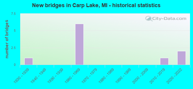
- New bridges - historical statistics
- 11930-1939
- 61960-1969
- 12010-2019
- 22020-2022


- Bridge Condition - Deck
- 16.7%Excellent
- 33.3%Very good
- 50.0%Good

- Bridge Condition - Superstructure
- 16.7%Excellent
- 33.3%Very good
- 16.7%Good
- 33.3%Satisfactory

- Bridge Condition - Substructure
- 16.7%Very good
- 50.0%Good
- 33.3%Satisfactory

- Bridge Condition - Channel
- 16.7%Good
- 33.3%Satisfactory
- 50.0%Fair

- Bridge Condition - Culverts
- 50.0%Fair
- 50.0%Poor
Find on map >> Show street view
Structure Number: 1517, Location: 4.4 MI S OF US-31 (Lat: 45.679108, Lng: -84.680547), Route carried "on" structure: County highway , Year Built: 1960, Status: Open, Structure Length: 8.96m (29.40ft), Average Daily Traffic: 40 (year 1997), Truck Traffic: 3%, Average Future Daily Traffic: 65 (year 2007), Design Load: H 15, Features Intersected: I-75, Facility Carried by Structure: HEBRON TOWN HALL R
Minimum Vertical Clearance: 30.48m (100.00ft), Kilometerpoint: 3.320, Lanes on structure: 2, Lanes under structure: 4, Owner: State Highway Agency, Approaching Roadway Width: 10.9m (35.8ft), Skew: 3 degrees, Material/Design: Concrete continuous, Design/Construction: Tee Beam, Number Of Spans In Main Unit: 4, Length of Maximum Span: 28.0m (91.9ft), Curb or Sidewalk Widths: Left: 0.7m (2.3ft), Right: 0.7m (2.3ft), Curb-To-Curb Width: 7.3m (24.0ft), Out-to-Out Width: 9.5m (31.2ft)
Condition: Deck: Good, Superstructure: Good, Substructure: Good, Operating Rating: 60.9 metric tons, Method Used To Determine Operating Rating: Load Factor (LF) rating reported by rating factor (RF) method using MS18 loading, Inventory Rating: 36.6 metric tons, Method Used To Determine Inventory Rating: Load Factor (LF) rating reported by rating factor (RF) method using MS18 loading, Structural Evaluation: Better than present minimum criteria, Deck Geometry: Equal to present minimum criteria, Underclear: Meets minimum limits, Approach Roadway Alignment: Somewhat better than minimum adequacy, Length Of Structure Improvement: 8.96m (29.40ft), Designated Inspection Frequency: Every 24 months, Inspection Date: April 2021, Bridge Improvement Cost: $101,000, Deck Structure Type: Concrete Cast-file-Place, Wearing Surface/Protective System: Wearing Surface: Epoxy Overlay
Find on map >> Show street view
Structure Number: 1518, Location: 0.6 MI S OF US-31 (Lat: 45.722956, Lng: -84.728214), Route carried "on" structure: County highway , Year Built: 1960, Status: Open, Structure Length: 7.34m (24.08ft), Average Daily Traffic: 60 (year 1997), Truck Traffic: 3%, Average Future Daily Traffic: 100 (year 2007), Design Load: H 15, Features Intersected: I-75, Facility Carried by Structure: POTTER RD
Minimum Vertical Clearance: 30.48m (100.00ft), Kilometerpoint: 0.293, Lanes on structure: 2, Lanes under structure: 4, Owner: State Highway Agency, Approaching Roadway Width: 11.8m (38.7ft), Skew: 2 degrees, Material/Design: Concrete continuous, Design/Construction: Tee Beam, Number Of Spans In Main Unit: 4, Length of Maximum Span: 22.8m (74.8ft), Curb or Sidewalk Widths: Left: 0.7m (2.3ft), Right: 0.7m (2.3ft), Curb-To-Curb Width: 7.3m (24.0ft), Out-to-Out Width: 9.5m (31.2ft)
Condition: Deck: Good, Superstructure: Satisfactory, Substructure: Satisfactory, Operating Rating: 60.6 metric tons, Method Used To Determine Operating Rating: Load Factor (LF) rating reported by rating factor (RF) method using MS18 loading, Inventory Rating: 36.3 metric tons, Method Used To Determine Inventory Rating: Load Factor (LF) rating reported by rating factor (RF) method using MS18 loading, Structural Evaluation: Equal to present minimum criteria, Deck Geometry: Equal to present minimum criteria, Underclear: Meets minimum limits, Approach Roadway Alignment: Somewhat better than minimum adequacy, Designated Inspection Frequency: Every 24 months, Inspection Date: April 2021, Deck Structure Type: Concrete Cast-file-Place, Wearing Surface/Protective System: Wearing Surface: Epoxy Overlay
Find on map >> Show street view
Structure Number: 245, Location: 4.1 MI SW CHEBOYGAN COL (Lat: 45.684208, Lng: -84.781397), Route carried "on" structure: US 31, Year Built: 1933, Status: Open, Structure Length: 0.94m (3.08ft), Average Daily Traffic: 4,661 (year 2007), Truck Traffic: 7%, Average Future Daily Traffic: 6,799 (year 2018), Design Load: H 15, Features Intersected: CARP LAKE RIVER
Minimum Vertical Clearance: 30.48m (100.00ft), Kilometerpoint: 44.701, Lanes on structure: 2, Base Highway Network: Yes (Inventory Route: 116, Subroute: 7), Owner: State Highway Agency, Approaching Roadway Width: 12.2m (40.0ft), Skew: 3 degrees, Material/Design: Concrete, Design/Construction: Tee Beam, Number Of Spans In Main Unit: 1, Length of Maximum Span: 9.4m (30.8ft), Curb-To-Curb Width: 11.0m (36.1ft), Out-to-Out Width: 11.6m (38.1ft)
Condition: Deck: Good, Superstructure: Satisfactory, Substructure: Satisfactory, Channel: Satisfactory, Operating Rating: 72.9 metric tons, Method Used To Determine Operating Rating: Load Factor (LF) rating reported by rating factor (RF) method using MS18 loading, Inventory Rating: 43.7 metric tons, Method Used To Determine Inventory Rating: Load Factor (LF) rating reported by rating factor (RF) method using MS18 loading, Structural Evaluation: Equal to present minimum criteria, Deck Geometry: Somewhat better than minimum adequacy, Waterway Adequacy: Equal to present desirable criteria, Approach Roadway Alignment: Equal to present desirable criteria, Designated Inspection Frequency: Every 24 months, Inspection Date: July 2021, Deck Structure Type: Concrete Cast-file-Place, Wearing Surface/Protective System: Wearing Surface: Bituminous
Find on map >> Show street view
Structure Number: 12795, Location: SEC. 29 WAWATAM TWP. (Lat: 45.745578, Lng: -84.829781), Route carried "on" structure: County highway 81, Year Built: 1968, Status: Open, Structure Length: 0.77m (2.53ft), Average Daily Traffic: 1,326 (year 2003), Truck Traffic: 7%, Average Future Daily Traffic: 711 (year 2023), Features Intersected: CARP RIVER, Facility Carried by Structure: WILDERNESS PARK DR
Minimum Vertical Clearance: 30.48m (100.00ft), Kilometerpoint: 11.589, Lanes on structure: 2, Owner: County Highway Agency, Approaching Roadway Width: 9.1m (29.9ft), Skew: 1 degrees, Material/Design: Steel, Design/Construction: Culvert, Number Of Spans In Main Unit: 2, Length of Maximum Span: 3.1m (10.2ft)
Condition: Channel: Satisfactory, Culverts: Fair, Operating Rating: 56.7 metric tons, Method Used To Determine Operating Rating: Load Factor (LF) rating reported by rating factor (RF) method using MS18 loading, Inventory Rating: 34.0 metric tons, Method Used To Determine Inventory Rating: Load Factor (LF) rating reported by rating factor (RF) method using MS18 loading, Structural Evaluation: Somewhat better than minimum adequacy, Waterway Adequacy: Equal to present desirable criteria, Approach Roadway Alignment: Equal to present desirable criteria, Designated Inspection Frequency: Every 24 months, Inspection Date: August 2020
Find on map >> Show street view
Structure Number: 12796, Location: SEC 21&22 CARP LAKE TWP. (Lat: 45.677039, Lng: -84.791939), Route carried "on" structure: County highway , Year Built: 2020, Status: Open, Structure Length: 0.80m (2.62ft), Average Daily Traffic: 50 (year 2020), Truck Traffic: 1%, Average Future Daily Traffic: 100 (year 2040), Design Load: HL 93, Features Intersected: CARP LAKE RIVER, Facility Carried by Structure: REED ROAD
Minimum Vertical Clearance: 30.48m (100.00ft), Kilometerpoint: 10.812, Lanes on structure: 2, Owner: County Highway Agency, Approaching Roadway Width: 9.1m (29.9ft), Skew: 2 degrees, Material/Design: Wood or Timber, Design/Construction: Slab, Number Of Spans In Main Unit: 1, Length of Maximum Span: 8.0m (26.2ft), Curb-To-Curb Width: 9.1m (29.9ft), Out-to-Out Width: 9.8m (32.2ft)
Condition: Deck: Excellent, Superstructure: Excellent, Substructure: Good, Channel: Fair, Operating Rating: 70.6 metric tons, Method Used To Determine Operating Rating: Load and Resistance Factor Rating (LRFR) rating reported by rating factor(RF) method using HL-93 loadings, Inventory Rating: 48.9 metric tons, Method Used To Determine Inventory Rating: Load and Resistance Factor Rating (LRFR) rating reported by rating factor(RF) method using HL-93 loadings, Structural Evaluation: Better than present minimum criteria, Deck Geometry: Better than present minimum criteria, Waterway Adequacy: Equal to present desirable criteria, Approach Roadway Alignment: Equal to present desirable criteria, Designated Inspection Frequency: Every 24 months, Inspection Date: December 2020, Bridge Improvement Cost: $60,000, Roadway Improvement Cost: $80,000, Total Project Cost: $180,000, Deck Structure Type: Wood or Timber, Wearing Surface/Protective System: Wearing Surface: Bituminous
Find on map >> Show street view
Structure Number: 13421, Location: HEBRON TWP SEC 19 (Lat: 45.678889, Lng: -84.722889), Route carried "on" structure: County highway , Year Built: 1963, Status: Posted for load, Structure Length: 1.01m (3.31ft), Average Daily Traffic: 100 (year 2007), Average Future Daily Traffic: 1,800 (year 2002), Design Load: HS 20, Features Intersected: MUD CREEK, Facility Carried by Structure: PARADISE LAKE ROAD
Minimum Vertical Clearance: 30.48m (100.00ft), Kilometerpoint: 2.639, Lanes on structure: 2, Owner: County Highway Agency, Approaching Roadway Width: 7.3m (24.0ft), Skew: 4 degrees, Material/Design: Steel, Design/Construction: Culvert, Number Of Spans In Main Unit: 3, Length of Maximum Span: 2.7m (8.9ft), Curb-To-Curb Width: 6.1m (20.0ft), Out-to-Out Width: 7.3m (24.0ft)
Condition: Channel: Fair, Culverts: Poor, Operating Rating: 12.1 metric tons, Method Used To Determine Operating Rating: Load Testing, Inventory Rating: 7.3 metric tons, Method Used To Determine Inventory Rating: Load Testing, Structural Evaluation: High priority of corrective action, Deck Geometry: Somewhat better than minimum adequacy, Waterway Adequacy: Somewhat better than minimum adequacy, Approach Roadway Alignment: Meets minimum limits, Bridge Posting: Required (Relationship of Operating Rating to Maximum Legal Load: > 39.9% below), Designated Inspection Frequency: Every 12 months, Inspection Date: July 2021, Wearing Surface/Protective System: Wearing Surface: Gravel
Find on map >> Show street view
Structure Number: 14322, Location: 1.2 MI W OF US-31 (Lat: 45.694519, Lng: -84.804806), Route carried "on" structure: County highway 2476, Year Built: 2019, Status: Open, Structure Length: 0.67m (2.20ft), Average Daily Traffic: 289 (year 2018), Average Future Daily Traffic: 332 (year 2038), Design Load: Greater than HL93, Features Intersected: CARP LAKE RIVER, Facility Carried by Structure: GILL RD
Minimum Vertical Clearance: 30.48m (100.00ft), Kilometerpoint: 10.392, Lanes on structure: 2, Owner: County Highway Agency, Approaching Roadway Width: 10.7m (35.1ft), Material/Design: Wood or Timber, Design/Construction: Slab, Number Of Spans In Main Unit: 1, Length of Maximum Span: 6.7m (22.0ft), Curb-To-Curb Width: 10.7m (35.1ft), Out-to-Out Width: 11.3m (37.1ft)
Condition: Deck: Very good, Superstructure: Very good, Substructure: Very good, Channel: Good, Operating Rating: 66.7 metric tons, Method Used To Determine Operating Rating: Load and Resistance Factor Rating (LRFR) rating reported by rating factor(RF) method using HL-93 loadings, Inventory Rating: 47.6 metric tons, Method Used To Determine Inventory Rating: Load and Resistance Factor Rating (LRFR) rating reported by rating factor(RF) method using HL-93 loadings, Structural Evaluation: Equal to present desirable criteria, Deck Geometry: Better than present minimum criteria, Waterway Adequacy: Equal to present desirable criteria, Approach Roadway Alignment: Better than present minimum criteria, Designated Inspection Frequency: Every 24 months, Inspection Date: August 2020, Deck Structure Type: Wood or Timber, Wearing Surface/Protective System: Wearing Surface: Bituminous
Find on map >> Show street view
Structure Number: 14385, Location: 1.05 MI W OF REED RD (Lat: 45.679986, Lng: -84.813733), Route carried "on" structure: County highway , Year Built: 2020, Status: Open, Structure Length: 0.86m (2.82ft), Average Daily Traffic: 50 (year 2020), Truck Traffic: 1%, Average Future Daily Traffic: 100 (year 2040), Design Load: HL 93, Features Intersected: CARP LAKE RIVER, Facility Carried by Structure: MUNGER RD
Minimum Vertical Clearance: 30.48m (100.00ft), Kilometerpoint: 7.514, Lanes on structure: 2, Owner: County Highway Agency, Approaching Roadway Width: 8.5m (27.9ft), Skew: 2 degrees, Material/Design: Wood or Timber, Design/Construction: Slab, Number Of Spans In Main Unit: 1, Length of Maximum Span: 8.6m (28.2ft), Curb-To-Curb Width: 8.5m (27.9ft), Out-to-Out Width: 8.9m (29.2ft)
Condition: Deck: Very good, Superstructure: Very good, Substructure: Good, Channel: Fair, Operating Rating: 70.0 metric tons, Method Used To Determine Operating Rating: Load and Resistance Factor Rating (LRFR) rating reported by rating factor(RF) method using HL-93 loadings, Inventory Rating: 48.6 metric tons, Method Used To Determine Inventory Rating: Load and Resistance Factor Rating (LRFR) rating reported by rating factor(RF) method using HL-93 loadings, Structural Evaluation: Better than present minimum criteria, Deck Geometry: Better than present minimum criteria, Waterway Adequacy: Equal to present desirable criteria, Approach Roadway Alignment: Equal to present minimum criteria, Designated Inspection Frequency: Every 24 months, Inspection Date: December 2020, Deck Structure Type: Wood or Timber, Wearing Surface/Protective System: Wearing Surface: Bituminous
Find on map >> Show street view
Structure Number: 1517, Location: 4.4 MI S OF US-31 (Lat: 45.679108, Lng: -84.680547), Route carried "under" structure: Interstate 75, Year Built: 1960, Structure Length: 0. m, Average Daily Traffic: 7,310 (year 2007), Truck Traffic: 14%, Features Intersected: I-75, Facility Carried by Structure: HEBRON TOWN HALL R
Minimum Vertical Clearance: 5.51m (18.08ft), Kilometerpoint: 57.658, Lanes on structure: 2, Lanes under structure: 4, Material/Design: Concrete continuous, Design/Construction: Tee Beam, Length of Maximum Span: 28.0m (91.9ft)
Find on map >> Show street view
Structure Number: 1518, Location: 0.6 MI S OF US-31 (Lat: 45.722956, Lng: -84.728214), Route carried "under" structure: Interstate 75, Year Built: 1960, Structure Length: 0. m, Average Daily Traffic: 7,310 (year 2007), Truck Traffic: 14%, Features Intersected: I-75, Facility Carried by Structure: POTTER RD
Minimum Vertical Clearance: 5.26m (17.26ft), Kilometerpoint: 64.175, Lanes on structure: 2, Lanes under structure: 4, Material/Design: Concrete continuous, Design/Construction: Tee Beam, Length of Maximum Span: 22.8m (74.8ft)