Bridge Statistics for Carol City, Florida (FL)
Condition, Traffic, Stress, Structural Evaluation, Project Costs
- National Bridge Inventory (NBI) Statistics
- 48Number of bridges
- 614ft / 187mTotal length
- $5,200,000Total costs
- 1,975,712Total average daily traffic
- 149,282Total average daily truck traffic
- National Bridge Inventory (NBI) Registered Bridges for Carol City
- No street view available for this location
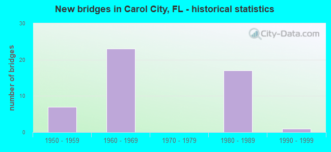
- New bridges - historical statistics
- 71950-1959
- 231960-1969
- 171980-1989
- 11990-1999

- Reconstructed bridges - Historical Statistics
- 71970-1979
- 31980-1989
- 01990-1999
- 22000-2009


- Bridge Condition - Deck
- 96.6%Good
- 3.4%Satisfactory

- Bridge Condition - Superstructure
- 20.7%Very good
- 48.3%Good
- 24.1%Satisfactory
- 6.9%Fair

- Bridge Condition - Substructure
- 6.9%Very good
- 93.1%Good

- Bridge Condition - Channel
- 9.1%Very good
- 63.6%Good
- 18.2%Satisfactory
- 9.1%Fair
Find on map >> Show street view
Structure Number: 870035, Location: 0.5 MI E OF SR 817 (Lat: 25.926658, Lng: -80.236633), Route carried "on" structure: State highway 826, Year Built: 1962, Year Reconstructed: 1978, Status: Open, Structure Length: 5.44m (17.85ft), Average Daily Traffic: 127,000 (year 2020), Truck Traffic: 7%, Average Future Daily Traffic: 220,345 (year 2042), Design Load: HS 20, Features Intersected: NW 22ND AVE
Minimum Vertical Clearance: 30+ m (98+ ft), Kilometerpoint: 36.188, Lanes on structure: 8, Lanes under structure: 6, Base Highway Network: Yes, Owner: State Highway Agency, Approaching Roadway Width: 39.6m (129.9ft), Skew: 30 degrees, Material/Design: Prestressed concrete, Design/Construction: Stringer/Multi-beam, Number Of Spans In Main Unit: 4, Length of Maximum Span: 16.5m (54.1ft), Curb-To-Curb Width: 39.6m (129.9ft), Out-to-Out Width: 41.1m (134.8ft)
Condition: Deck: Good, Superstructure: Good, Substructure: Good, Operating Rating: 50.8 metric tons, Method Used To Determine Operating Rating: Load Factor (LF), Inventory Rating: 30.4 metric tons, Method Used To Determine Inventory Rating: Load Factor (LF), Structural Evaluation: Better than present minimum criteria, Deck Geometry: Superior to present desirable criteria, Underclear: High priority of corrective action, Approach Roadway Alignment: Equal to present desirable criteria, Designated Inspection Frequency: Every 24 months, Inspection Date: April 2020, Deck Structure Type: Concrete Cast-file-Place
Find on map >> Show street view
Structure Number: 870045, Location: GOLDEN GLADES INTERCHANGE (Lat: 25.924917, Lng: -80.211756), Route carried "on" structure: Ramp State highway 91, Year Built: 1967, Year Reconstructed: 1986, Status: Open, Structure Length: 7.22m (23.69ft), Average Daily Traffic: 19,500 (year 2020), Truck Traffic: 17%, Average Future Daily Traffic: 33,832 (year 2042), Design Load: HS 20, Features Intersected: US-441
Minimum Vertical Clearance: 30+ m (98+ ft), Kilometerpoint: 0.819, Lanes on structure: 3, Lanes under structure: 5, Toll: On toll road, Owner: State Highway Agency, Approaching Roadway Width: 18.4m (60.4ft), Skew: 2 degrees, Material/Design: Prestressed concrete, Design/Construction: Stringer/Multi-beam, Number Of Spans In Main Unit: 4, Length of Maximum Span: 23.5m (77.1ft), Curb-To-Curb Width: 18.4m (60.4ft), Out-to-Out Width: 19.2m (63.0ft)
Condition: Deck: Good, Superstructure: Satisfactory, Substructure: Good, Operating Rating: 54.7 metric tons, Method Used To Determine Operating Rating: Load Factor (LF), Inventory Rating: 32.7 metric tons, Method Used To Determine Inventory Rating: Load Factor (LF), Structural Evaluation: Equal to present minimum criteria, Deck Geometry: Superior to present desirable criteria, Underclear: Somewhat better than minimum adequacy, Approach Roadway Alignment: Equal to present desirable criteria, Designated Inspection Frequency: Every 24 months, Inspection Date: Febuary 2021, Deck Structure Type: Concrete Cast-file-Place
Find on map >> Show street view
Structure Number: 870048, Location: 0.5MI W OF SR-817 (Lat: 25.926194, Lng: -80.252556), Route carried "on" structure: State highway 826, Year Built: 1965, Year Reconstructed: 1993, Status: Open, Structure Length: 5.46m (17.91ft), Average Daily Traffic: 73,500 (year 2019), Truck Traffic: 6%, Average Future Daily Traffic: 127,522 (year 2041), Design Load: HL 93, Features Intersected: NW 32ND AVE
Minimum Vertical Clearance: 30+ m (98+ ft), Kilometerpoint: 34.577, Lanes on structure: 3, Lanes under structure: 4, Base Highway Network: Yes, Toll: On toll road, Owner: State Highway Agency, Approaching Roadway Width: 16.1m (52.8ft), Material/Design: Prestressed concrete, Design/Construction: Stringer/Multi-beam, Number Of Spans In Main Unit: 4, Length of Maximum Span: 16.5m (54.1ft), Curb-To-Curb Width: 16.1m (52.8ft), Out-to-Out Width: 17.0m (55.8ft)
Condition: Deck: Good, Superstructure: Satisfactory, Substructure: Good, Operating Rating: 49.6 metric tons, Method Used To Determine Operating Rating: Load and Resistance Factor (LRFR), Inventory Rating: 34.7 metric tons, Method Used To Determine Inventory Rating: Load and Resistance Factor (LRFR), Structural Evaluation: Equal to present minimum criteria, Deck Geometry: Equal to present minimum criteria, Underclear: Somewhat better than minimum adequacy, Approach Roadway Alignment: Equal to present desirable criteria, Designated Inspection Frequency: Every 24 months, Inspection Date: April 2021, Deck Structure Type: Concrete Cast-file-Place
Find on map >> Show street view
Structure Number: 87005, Location: 0.7 Ml W OF GOLDEN GLADES (Lat: 25.927231, Lng: -80.221644), Route carried "on" structure: State highway 826, Year Built: 1965, Year Reconstructed: 1986, Status: Open, Structure Length: 4.31m (14.14ft), Average Daily Traffic: 144,000 (year 2021), Truck Traffic: 6%, Average Future Daily Traffic: 249,840 (year 2041), Design Load: HL 93, Features Intersected: NW 12TH & 13TH AVE.
Minimum Vertical Clearance: 30+ m (98+ ft), Kilometerpoint: 37.692, Lanes on structure: 8, Lanes under structure: 5, Base Highway Network: Yes, Owner: State Highway Agency, Approaching Roadway Width: 39.6m (129.9ft), Skew: 30 degrees, Material/Design: Prestressed concrete, Design/Construction: Stringer/Multi-beam, Number Of Spans In Main Unit: 3, Length of Maximum Span: 20.8m (68.2ft), Curb-To-Curb Width: 39.6m (129.9ft), Out-to-Out Width: 41.1m (134.8ft)
Condition: Deck: Good, Superstructure: Fair, Substructure: Good, Operating Rating: 36.9 metric tons, Method Used To Determine Operating Rating: Load and Resistance Factor (LRFR), Inventory Rating: 35.3 metric tons, Method Used To Determine Inventory Rating: Load and Resistance Factor (LRFR), Structural Evaluation: Somewhat better than minimum adequacy, Deck Geometry: Superior to present desirable criteria, Underclear: High priority of corrective action, Approach Roadway Alignment: Equal to present desirable criteria, Designated Inspection Frequency: Every 24 months, Inspection Date: August 2021, Deck Structure Type: Concrete Cast-file-Place
Find on map >> Show street view
Structure Number: 870051, Location: 1MI W OF NW 37TH AVE (Lat: 25.925306, Lng: -80.276500), Route carried "on" structure: State highway 826, Year Built: 1965, Year Reconstructed: 1977, Status: Open, Structure Length: 5.55m (18.21ft), Average Daily Traffic: 73,250 (year 2019), Truck Traffic: 6%, Average Future Daily Traffic: 127,089 (year 2041), Design Load: HS 20, Features Intersected: NW 47TH AVE
Minimum Vertical Clearance: 30+ m (98+ ft), Kilometerpoint: 32.164, Lanes on structure: 3, Lanes under structure: 6, Base Highway Network: Yes, Owner: State Highway Agency, Approaching Roadway Width: 16.0m (52.5ft), Material/Design: Prestressed concrete, Design/Construction: Stringer/Multi-beam, Number Of Spans In Main Unit: 4, Length of Maximum Span: 16.8m (55.1ft), Curb-To-Curb Width: 16.0m (52.5ft), Out-to-Out Width: 16.9m (55.4ft)
Condition: Deck: Good, Superstructure: Satisfactory, Substructure: Good, Operating Rating: 48.7 metric tons, Method Used To Determine Operating Rating: Load Factor (LF), Inventory Rating: 29.0 metric tons, Method Used To Determine Inventory Rating: Load Factor (LF), Structural Evaluation: Equal to present minimum criteria, Deck Geometry: Equal to present minimum criteria, Underclear: Meets minimum limits, Approach Roadway Alignment: Equal to present desirable criteria, Designated Inspection Frequency: Every 24 months, Inspection Date: April 2021, Deck Structure Type: Concrete Cast-file-Place
Find on map >> Show street view
Structure Number: 870104, Location: 1MI E OF SR817(NW27AVE) (Lat: 25.926889, Lng: -80.228472), Route carried "on" structure: State highway 826, Year Built: 1963, Year Reconstructed: 1978, Status: Open, Structure Length: 4.40m (14.44ft), Average Daily Traffic: 127,000 (year 2020), Truck Traffic: 7%, Average Future Daily Traffic: 220,345 (year 2042), Design Load: HS 20, Features Intersected: NW 17TH AVE
Minimum Vertical Clearance: 30+ m (98+ ft), Kilometerpoint: 37.008, Lanes on structure: 8, Lanes under structure: 4, Base Highway Network: Yes, Owner: State Highway Agency, Approaching Roadway Width: 39.8m (130.6ft), Skew: 30 degrees, Material/Design: Prestressed concrete, Design/Construction: Stringer/Multi-beam, Number Of Spans In Main Unit: 3, Length of Maximum Span: 22.2m (72.8ft), Curb-To-Curb Width: 39.8m (130.6ft), Out-to-Out Width: 41.3m (135.5ft)
Condition: Deck: Good, Superstructure: Satisfactory, Substructure: Good, Operating Rating: 50.1 metric tons, Method Used To Determine Operating Rating: Load Factor (LF), Inventory Rating: 30.0 metric tons, Method Used To Determine Inventory Rating: Load Factor (LF), Structural Evaluation: Equal to present minimum criteria, Deck Geometry: Superior to present desirable criteria, Underclear: Meets minimum limits, Approach Roadway Alignment: Equal to present desirable criteria, Designated Inspection Frequency: Every 24 months, Inspection Date: March 2021, Deck Structure Type: Concrete Cast-file-Place
Find on map >> Show street view
Structure Number: 870159, Location: GOLDEN GLADES INTERCHANGE (Lat: 25.926019, Lng: -80.211908), Route carried "on" structure: Ramp State highway 95, Year Built: 1964, Status: Open, Structure Length: 6.26m (20.54ft), Average Daily Traffic: 19,500 (year 2020), Truck Traffic: 17%, Average Future Daily Traffic: 33,832 (year 2042), Design Load: HS 20, Features Intersected: CSX RR
Minimum Vertical Clearance: 30+ m (98+ ft), Kilometerpoint: 0.711, Lanes on structure: 3, Owner: State Highway Agency, Approaching Roadway Width: 18.4m (60.4ft), Skew: 3 degrees, Material/Design: Prestressed concrete, Design/Construction: Stringer/Multi-beam, Number Of Spans In Main Unit: 3, Length of Maximum Span: 26.5m (86.9ft), Curb-To-Curb Width: 18.4m (60.4ft), Out-to-Out Width: 19.3m (63.3ft)
Condition: Deck: Good, Superstructure: Very good, Substructure: Good, Operating Rating: 42.5 metric tons, Method Used To Determine Operating Rating: Load and Resistance Factor (LRFR), Inventory Rating: 30.0 metric tons, Method Used To Determine Inventory Rating: Load and Resistance Factor (LRFR), Structural Evaluation: Better than present minimum criteria, Deck Geometry: Superior to present desirable criteria, Underclear: Meets minimum limits, Approach Roadway Alignment: Equal to present desirable criteria, Designated Inspection Frequency: Every 24 months, Inspection Date: July 2021, Deck Structure Type: Concrete Cast-file-Place, Wearing Surface/Protective System: Wearing Surface: Bituminous
Find on map >> Show street view
Structure Number: 870234, Location: AT NW 37TH AVE (Lat: 25.925694, Lng: -80.260667), Route carried "on" structure: State highway 826, Year Built: 1964, Year Reconstructed: 1977, Status: Open, Structure Length: 5.43m (17.81ft), Average Daily Traffic: 155,500 (year 2022), Truck Traffic: 6%, Average Future Daily Traffic: 269,792 (year 2042), Design Load: HS 20, Features Intersected: NW 37TH AVE
Minimum Vertical Clearance: 30+ m (98+ ft), Kilometerpoint: 33.775, Lanes on structure: 6, Lanes under structure: 6, Base Highway Network: Yes, Owner: State Highway Agency, Approaching Roadway Width: 32.5m (106.6ft), Skew: 30 degrees, Material/Design: Prestressed concrete, Design/Construction: Stringer/Multi-beam, Number Of Spans In Main Unit: 4, Length of Maximum Span: 16.2m (53.1ft), Curb-To-Curb Width: 32.5m (106.6ft), Out-to-Out Width: 34.1m (111.9ft)
Condition: Deck: Good, Superstructure: Fair, Substructure: Good, Operating Rating: 46.9 metric tons, Method Used To Determine Operating Rating: Load Factor (LF), Inventory Rating: 28.4 metric tons, Method Used To Determine Inventory Rating: Load Factor (LF), Structural Evaluation: Somewhat better than minimum adequacy, Deck Geometry: Superior to present desirable criteria, Underclear: Meets minimum limits, Approach Roadway Alignment: Equal to present desirable criteria, Designated Inspection Frequency: Every 24 months, Other Special Inspection Frequency: Every 12 months, Inspection Date: Febuary 2021, Other Special Inspection Date: Febuary 2022, Deck Structure Type: Concrete Cast-file-Place
Find on map >> Show street view
Structure Number: 870239, Location: NW 27TH AVE (Lat: 25.926333, Lng: -80.244611), Route carried "on" structure: State highway 826, Year Built: 1964, Year Reconstructed: 1978, Status: Open, Structure Length: 5.27m (17.29ft), Average Daily Traffic: 147,000 (year 2020), Truck Traffic: 6%, Average Future Daily Traffic: 255,045 (year 2042), Design Load: HS 20, Features Intersected: SR-817 (NW 27TH AVE)
Minimum Vertical Clearance: 30+ m (98+ ft), Kilometerpoint: 35.386, Lanes on structure: 6, Lanes under structure: 8, Base Highway Network: Yes, Owner: State Highway Agency, Approaching Roadway Width: 16.0m (52.5ft), Material/Design: Prestressed concrete, Design/Construction: Stringer/Multi-beam, Number Of Spans In Main Unit: 4, Length of Maximum Span: 16.2m (53.1ft), Curb-To-Curb Width: 32.1m (105.3ft), Out-to-Out Width: 33.6m (110.2ft)
Condition: Deck: Good, Superstructure: Satisfactory, Substructure: Good, Operating Rating: 60.0 metric tons, Method Used To Determine Operating Rating: Load Factor (LF), Inventory Rating: 36.5 metric tons, Method Used To Determine Inventory Rating: Load Factor (LF), Structural Evaluation: Equal to present minimum criteria, Deck Geometry: Superior to present desirable criteria, Underclear: High priority of corrective action, Approach Roadway Alignment: Equal to present desirable criteria, Designated Inspection Frequency: Every 24 months, Inspection Date: July 2021, Deck Structure Type: Concrete Cast-file-Place
Find on map >> Show street view
Structure Number: 870245, Location: GOLDEN GLADES INTERCHANGE (Lat: 25.925108, Lng: -80.211564), Route carried "on" structure: Ramp Interstate 95, Year Built: 1967, Status: Open, Structure Length: 7.22m (23.69ft), Average Daily Traffic: 47,000 (year 2020), Truck Traffic: 5%, Average Future Daily Traffic: 81,545 (year 2042), Design Load: HS 20, Features Intersected: US-441
Minimum Vertical Clearance: 30+ m (98+ ft), Kilometerpoint: 0.552, Lanes on structure: 3, Lanes under structure: 5, Toll: On toll road, Owner: State Highway Agency, Approaching Roadway Width: 12.1m (39.7ft), Skew: 1 degrees, Material/Design: Prestressed concrete, Design/Construction: Stringer/Multi-beam, Number Of Spans In Main Unit: 4, Length of Maximum Span: 23.5m (77.1ft), Curb-To-Curb Width: 12.1m (39.7ft), Out-to-Out Width: 14.0m (45.9ft)
Condition: Deck: Good, Superstructure: Satisfactory, Substructure: Good, Operating Rating: 51.4 metric tons, Method Used To Determine Operating Rating: Load Factor (LF), Inventory Rating: 31.8 metric tons, Method Used To Determine Inventory Rating: Load Factor (LF), Structural Evaluation: Equal to present minimum criteria, Deck Geometry: High priority of corrective action, Underclear: Somewhat better than minimum adequacy, Approach Roadway Alignment: Equal to present desirable criteria, Designated Inspection Frequency: Every 24 months, Inspection Date: Febuary 2021, Deck Structure Type: Concrete Cast-file-Place
Find on map >> Show street view
Structure Number: 870249, Location: 1.5 MILES E OF SR-823 (Lat: 25.925461, Lng: -80.268669), Route carried "on" structure: State highway 826, Year Built: 1965, Year Reconstructed: 1977, Status: Open, Structure Length: 5.43m (17.81ft), Average Daily Traffic: 155,500 (year 2022), Truck Traffic: 6%, Average Future Daily Traffic: 269,792 (year 2042), Design Load: HL 93, Features Intersected: NW 42ND AVE (LEJEUNE RD)
Minimum Vertical Clearance: 30+ m (98+ ft), Kilometerpoint: 32.971, Lanes on structure: 6, Lanes under structure: 4, Base Highway Network: Yes, Owner: State Highway Agency, Approaching Roadway Width: 32.0m (105.0ft), Material/Design: Prestressed concrete, Design/Construction: Stringer/Multi-beam, Number Of Spans In Main Unit: 4, Length of Maximum Span: 16.4m (53.8ft), Curb-To-Curb Width: 32.0m (105.0ft), Out-to-Out Width: 33.9m (111.2ft)
Condition: Deck: Good, Superstructure: Good, Substructure: Very good, Operating Rating: 48.4 metric tons, Method Used To Determine Operating Rating: Load and Resistance Factor (LRFR), Inventory Rating: 36.9 metric tons, Method Used To Determine Inventory Rating: Load and Resistance Factor (LRFR), Structural Evaluation: Better than present minimum criteria, Deck Geometry: Superior to present desirable criteria, Underclear: Meets minimum limits, Approach Roadway Alignment: Equal to present desirable criteria, Designated Inspection Frequency: Every 24 months, Inspection Date: Febuary 2022
Find on map >> Show street view
Structure Number: 870251, Location: 1MI W OF NW 37TH AVE (Lat: 25.925139, Lng: -80.276583), Route carried "on" structure: State highway 826, Year Built: 1965, Year Reconstructed: 1977, Status: Open, Structure Length: 5.55m (18.21ft), Average Daily Traffic: 73,250 (year 2019), Truck Traffic: 6%, Average Future Daily Traffic: 127,089 (year 2041), Design Load: HS 20, Features Intersected: NW 47TH AVE
Minimum Vertical Clearance: 30+ m (98+ ft), Kilometerpoint: 32.164, Lanes on structure: 3, Lanes under structure: 6, Base Highway Network: Yes, Toll: Toll bridge, Owner: State Highway Agency, Approaching Roadway Width: 16.0m (52.5ft), Material/Design: Prestressed concrete, Design/Construction: Stringer/Multi-beam, Number Of Spans In Main Unit: 4, Length of Maximum Span: 16.5m (54.1ft), Curb-To-Curb Width: 16.0m (52.5ft), Out-to-Out Width: 16.9m (55.4ft)
Condition: Deck: Good, Superstructure: Satisfactory, Substructure: Good, Operating Rating: 49.7 metric tons, Method Used To Determine Operating Rating: Load Factor (LF), Inventory Rating: 29.8 metric tons, Method Used To Determine Inventory Rating: Load Factor (LF), Structural Evaluation: Equal to present minimum criteria, Deck Geometry: Equal to present minimum criteria, Underclear: Meets minimum limits, Approach Roadway Alignment: Equal to present desirable criteria, Designated Inspection Frequency: Every 24 months, Inspection Date: April 2021, Deck Structure Type: Concrete Cast-file-Place
Find on map >> Show street view
Structure Number: 87038, Location: GOLDEN GLADES INTERCHANGE (Lat: 25.926056, Lng: -80.211739), Route carried "on" structure: Ramp State highway 95, Year Built: 1957, Year Reconstructed: 2011, Status: Open, Structure Length: 5.28m (17.32ft), Average Daily Traffic: 47,000 (year 2020), Truck Traffic: 5%, Average Future Daily Traffic: 81,545 (year 2042), Design Load: HL 93, Features Intersected: CSX RR
Minimum Vertical Clearance: 30+ m (98+ ft), Kilometerpoint: 0.676, Lanes on structure: 3, Owner: State Highway Agency, Approaching Roadway Width: 18.7m (61.4ft), Skew: 3 degrees, Material/Design: Prestressed concrete, Design/Construction: Stringer/Multi-beam, Number Of Spans In Main Unit: 3, Length of Maximum Span: 19.2m (63.0ft), Curb-To-Curb Width: 18.7m (61.4ft), Out-to-Out Width: 19.6m (64.3ft)
Condition: Deck: Good, Superstructure: Good, Substructure: Good, Operating Rating: 46.4 metric tons, Method Used To Determine Operating Rating: Load and Resistance Factor (LRFR), Inventory Rating: 35.9 metric tons, Method Used To Determine Inventory Rating: Load and Resistance Factor (LRFR), Structural Evaluation: Better than present minimum criteria, Deck Geometry: Superior to present desirable criteria, Underclear: Somewhat better than minimum adequacy, Approach Roadway Alignment: Equal to present desirable criteria, Designated Inspection Frequency: Every 24 months, Inspection Date: July 2021, Deck Structure Type: Concrete Cast-file-Place
Find on map >> Show street view
Structure Number: 870695, Location: 2.2 MILES N OF GOLD GLAD (Lat: 25.956142, Lng: -80.228997), Route carried "on" structure: State highway 91, Year Built: 1988, Status: Open, Structure Length: 5.73m (18.80ft), Average Daily Traffic: 48,300 (year 2020), Truck Traffic: 11%, Average Future Daily Traffic: 83,800 (year 2042), Design Load: HS 20+Mod, Features Intersected: NW 199 ST
Minimum Vertical Clearance: 30+ m (98+ ft), Kilometerpoint: 3.529, Lanes on structure: 3, Lanes under structure: 6, Base Highway Network: Yes, Toll: On toll road, Owner: State Toll Authority, Approaching Roadway Width: 17.7m (58.1ft), Material/Design: Prestressed concrete, Design/Construction: Stringer/Multi-beam, Number Of Spans In Main Unit: 3, Length of Maximum Span: 33.2m (108.9ft), Curb-To-Curb Width: 17.1m (56.1ft), Out-to-Out Width: 17.9m (58.7ft)
Condition: Deck: Good, Superstructure: Good, Substructure: Very good, Operating Rating: 49.4 metric tons, Method Used To Determine Operating Rating: Load Factor (LF), Inventory Rating: 29.6 metric tons, Method Used To Determine Inventory Rating: Load Factor (LF), Structural Evaluation: Better than present minimum criteria, Deck Geometry: Equal to present minimum criteria, Underclear: Equal to present minimum criteria, Approach Roadway Alignment: Equal to present desirable criteria, Designated Inspection Frequency: Every 24 months, Inspection Date: Febuary 2022, Deck Structure Type: Concrete Cast-file-Place
Find on map >> Show street view
Structure Number: 870696, Location: 2.2 MI N OF GOLDEN GLADE (Lat: 25.956147, Lng: -80.229261), Route carried "on" structure: State highway 91, Year Built: 1987, Status: Open, Structure Length: 5.73m (18.80ft), Average Daily Traffic: 48,300 (year 2020), Truck Traffic: 11%, Average Future Daily Traffic: 83,800 (year 2042), Design Load: HS 20+Mod, Features Intersected: NW 199 ST
Minimum Vertical Clearance: 30+ m (98+ ft), Kilometerpoint: 3.529, Lanes on structure: 5, Lanes under structure: 6, Base Highway Network: Yes, Toll: On toll road, Owner: State Toll Authority, Approaching Roadway Width: 21.9m (71.9ft), Material/Design: Prestressed concrete, Design/Construction: Stringer/Multi-beam, Number Of Spans In Main Unit: 3, Length of Maximum Span: 33.2m (108.9ft), Curb-To-Curb Width: 23.4m (76.8ft), Out-to-Out Width: 23.9m (78.4ft)
Condition: Deck: Good, Superstructure: Very good, Substructure: Good, Operating Rating: 45.6 metric tons, Method Used To Determine Operating Rating: Load Factor (LF), Inventory Rating: 27.3 metric tons, Method Used To Determine Inventory Rating: Load Factor (LF), Structural Evaluation: Equal to present minimum criteria, Deck Geometry: Equal to present minimum criteria, Underclear: Equal to present minimum criteria, Approach Roadway Alignment: Equal to present desirable criteria, Designated Inspection Frequency: Every 24 months, Inspection Date: Febuary 2022, Deck Structure Type: Concrete Cast-file-Place
Find on map >> Show street view
Structure Number: 870697, Location: RMP TO PRO PLAYER STADIUM (Lat: 25.956125, Lng: -80.228819), Route carried "on" structure: Ramp State highway 91, Year Built: 1988, Status: Open, Structure Length: 5.73m (18.80ft), Average Daily Traffic: 1,600 (year 2020), Truck Traffic: 11%, Average Future Daily Traffic: 2,776 (year 2042), Design Load: HS 20+Mod, Features Intersected: NW 199 ST
Minimum Vertical Clearance: 30+ m (98+ ft), Kilometerpoint: 0.386, Lanes on structure: 2, Lanes under structure: 6, Toll: On toll road, Owner: State Toll Authority, Approaching Roadway Width: 14.6m (47.9ft), Material/Design: Prestressed concrete, Design/Construction: Stringer/Multi-beam, Number Of Spans In Main Unit: 3, Length of Maximum Span: 33.2m (108.9ft), Curb-To-Curb Width: 14.6m (47.9ft), Out-to-Out Width: 15.4m (50.5ft)
Condition: Deck: Good, Superstructure: Very good, Substructure: Good, Operating Rating: 50.5 metric tons, Method Used To Determine Operating Rating: Load Factor (LF), Inventory Rating: 33.3 metric tons, Method Used To Determine Inventory Rating: Load Factor (LF), Structural Evaluation: Better than present minimum criteria, Deck Geometry: Superior to present desirable criteria, Underclear: Equal to present minimum criteria, Approach Roadway Alignment: Better than present minimum criteria, Designated Inspection Frequency: Every 24 months, Inspection Date: Febuary 2022, Deck Structure Type: Concrete Cast-file-Place
Find on map >> Show street view
Structure Number: 870698, Location: 0.3 MILES N OF NW 199TH (Lat: 25.960606, Lng: -80.229175), Route carried "on" structure: State highway 91, Year Built: 1988, Status: Open, Structure Length: 5.52m (18.11ft), Average Daily Traffic: 48,300 (year 2020), Truck Traffic: 11%, Average Future Daily Traffic: 83,800 (year 2042), Design Load: HS 20+Mod, Features Intersected: SNAKE CREEK CANAL C-9
Minimum Vertical Clearance: 30+ m (98+ ft), Kilometerpoint: 4.027, Lanes on structure: 3, Base Highway Network: Yes, Toll: On toll road, Owner: State Toll Authority, Approaching Roadway Width: 17.3m (56.8ft), Material/Design: Prestressed concrete, Design/Construction: Stringer/Multi-beam, Number Of Spans In Main Unit: 3, Length of Maximum Span: 18.3m (60.0ft), Curb-To-Curb Width: 17.1m (56.1ft), Out-to-Out Width: 18.0m (59.1ft)
Condition: Deck: Good, Superstructure: Good, Substructure: Good, Channel: Good, Operating Rating: 47.7 metric tons, Method Used To Determine Operating Rating: Load and Resistance Factor (LRFR), Inventory Rating: 38.2 metric tons, Method Used To Determine Inventory Rating: Load and Resistance Factor (LRFR), Structural Evaluation: Better than present minimum criteria, Deck Geometry: Equal to present minimum criteria, Waterway Adequacy: Equal to present desirable criteria, Approach Roadway Alignment: Equal to present desirable criteria, Designated Inspection Frequency: Every 24 months, Underwater Inspection Frequency: Every 24 months, Inspection Date: Febuary 2022, Underwater Inspection Date: Febuary 2022, Deck Structure Type: Concrete Cast-file-Place
Find on map >> Show street view
Structure Number: 870699, Location: 0.3 MILES N OF NW 199 ST (Lat: 25.960644, Lng: -80.229450), Route carried "on" structure: State highway 91, Year Built: 1987, Status: Open, Structure Length: 5.49m (18.01ft), Average Daily Traffic: 48,300 (year 2020), Truck Traffic: 11%, Average Future Daily Traffic: 83,800 (year 2042), Design Load: HS 20+Mod, Features Intersected: SNAKE CREEK CANAL C-9
Minimum Vertical Clearance: 30+ m (98+ ft), Kilometerpoint: 4.027, Lanes on structure: 3, Base Highway Network: Yes, Toll: On toll road, Owner: State Toll Authority, Approaching Roadway Width: 23.7m (77.8ft), Material/Design: Prestressed concrete, Design/Construction: Stringer/Multi-beam, Number Of Spans In Main Unit: 3, Length of Maximum Span: 18.3m (60.0ft), Curb-To-Curb Width: 23.3m (76.4ft), Out-to-Out Width: 24.1m (79.1ft)
Condition: Deck: Good, Superstructure: Very good, Substructure: Good, Channel: Good, Operating Rating: 44.1 metric tons, Method Used To Determine Operating Rating: Load and Resistance Factor (LRFR), Inventory Rating: 35.9 metric tons, Method Used To Determine Inventory Rating: Load and Resistance Factor (LRFR), Structural Evaluation: Better than present minimum criteria, Deck Geometry: Superior to present desirable criteria, Waterway Adequacy: Equal to present desirable criteria, Approach Roadway Alignment: Equal to present desirable criteria, Designated Inspection Frequency: Every 24 months, Underwater Inspection Frequency: Every 24 months, Inspection Date: Febuary 2022, Underwater Inspection Date: Febuary 2022, Deck Structure Type: Concrete Cast-file-Place
Find on map >> Show street view
Structure Number: 8707, Location: 0.3 MILES N OF NW 199 ST (Lat: 25.960647, Lng: -80.229836), Route carried "on" structure: Ramp State highway 91, Year Built: 1988, Status: Open, Structure Length: 6.71m (22.01ft), Average Daily Traffic: 5,450 (year 2020), Truck Traffic: 11%, Average Future Daily Traffic: 9,456 (year 2042), Design Load: HS 20+Mod, Features Intersected: SNAKE CREEK CANAL C-9
Minimum Vertical Clearance: 30+ m (98+ ft), Kilometerpoint: 0.103, Lanes on structure: 2, Toll: On toll road, Owner: State Toll Authority, Approaching Roadway Width: 12.8m (42.0ft), Material/Design: Prestressed concrete, Design/Construction: Stringer/Multi-beam, Number Of Spans In Main Unit: 3, Length of Maximum Span: 28.3m (92.8ft), Curb-To-Curb Width: 12.5m (41.0ft), Out-to-Out Width: 13.0m (42.7ft)
Condition: Deck: Good, Superstructure: Good, Substructure: Good, Channel: Good, Operating Rating: 38.8 metric tons, Method Used To Determine Operating Rating: Load and Resistance Factor (LRFR), Inventory Rating: 30.0 metric tons, Method Used To Determine Inventory Rating: Load and Resistance Factor (LRFR), Structural Evaluation: Better than present minimum criteria, Deck Geometry: Superior to present desirable criteria, Waterway Adequacy: Equal to present desirable criteria, Approach Roadway Alignment: Equal to present minimum criteria, Designated Inspection Frequency: Every 24 months, Underwater Inspection Frequency: Every 24 months, Inspection Date: Febuary 2022, Underwater Inspection Date: Febuary 2022, Deck Structure Type: Concrete Cast-file-Place
Find on map >> Show street view
Structure Number: 870701, Location: 0.5M N OF NW 199 ST (Lat: 25.959769, Lng: -80.229242), Route carried "on" structure: Ramp State highway 91, Year Built: 1988, Status: Open, Structure Length: 23.87m (78.31ft), Average Daily Traffic: 5,450 (year 2021), Truck Traffic: 11%, Average Future Daily Traffic: 9,456 (year 2042), Design Load: HS 20, Features Intersected: SR 91 TPK & CANAL
Minimum Vertical Clearance: 6.28m (20.60ft), Kilometerpoint: 0.735, Lanes on structure: 1, Lanes under structure: 7, Toll: On toll road, Owner: State Toll Authority, Approaching Roadway Width: 12.2m (40.0ft), Material/Design: Steel continuous, Design/Construction: Stringer/Multi-beam, Number Of Spans In Main Unit: 5, Length of Maximum Span: 49.4m (162.1ft), Curb-To-Curb Width: 12.2m (40.0ft), Out-to-Out Width: 13.1m (43.0ft)
Condition: Deck: Good, Superstructure: Good, Substructure: Good, Channel: Very good, Operating Rating: 76.2 metric tons, Method Used To Determine Operating Rating: Load Factor (LF), Inventory Rating: 45.7 metric tons, Method Used To Determine Inventory Rating: Load Factor (LF), Structural Evaluation: Better than present minimum criteria, Deck Geometry: Superior to present desirable criteria, Underclear: Meets minimum limits, Waterway Adequacy: Equal to present desirable criteria, Approach Roadway Alignment: Equal to present minimum criteria, Designated Inspection Frequency: Every 24 months, Inspection Date: October 2021, Bridge Improvement Cost: $1,800,000, Total Project Cost: $1,800,000, Deck Structure Type: Concrete Cast-file-Place
Find on map >> Show street view
Structure Number: 870702, Location: RAMP N TO W (N NW 199 ST) (Lat: 25.959547, Lng: -80.229464), Route carried "on" structure: Ramp State highway 91, Year Built: 1988, Status: Open, Structure Length: 36.55m (119.91ft), Average Daily Traffic: 1,600 (year 2021), Truck Traffic: 11%, Average Future Daily Traffic: 2,776 (year 2042), Design Load: HS 20, Features Intersected: SR 91 TPK (DOLPHIN INT)
Minimum Vertical Clearance: 30+ m (98+ ft), Kilometerpoint: 0.661, Lanes on structure: 2, Lanes under structure: 11, Toll: On toll road, Owner: State Toll Authority, Approaching Roadway Width: 14.6m (47.9ft), Material/Design: Steel continuous, Design/Construction: Stringer/Multi-beam, Number Of Spans In Main Unit: 6, Length of Maximum Span: 62.2m (204.1ft), Curb-To-Curb Width: 14.6m (47.9ft), Out-to-Out Width: 15.5m (50.9ft)
Condition: Deck: Satisfactory, Superstructure: Good, Substructure: Good, Operating Rating: 70.6 metric tons, Method Used To Determine Operating Rating: Load Factor (LF), Inventory Rating: 42.4 metric tons, Method Used To Determine Inventory Rating: Load Factor (LF), Structural Evaluation: Better than present minimum criteria, Deck Geometry: Superior to present desirable criteria, Underclear: Meets minimum limits, Approach Roadway Alignment: Better than present minimum criteria, Designated Inspection Frequency: Every 24 months, Inspection Date: October 2021, Bridge Improvement Cost: $3,400,000, Total Project Cost: $3,400,000, Deck Structure Type: Concrete Cast-file-Place
Find on map >> Show street view
Structure Number: 870707, Location: 0.3M N OF NW 199 ST (Lat: 25.960089, Lng: -80.230392), Route carried "on" structure: Ramp State highway 91, Year Built: 1988, Status: Open, Structure Length: 2.19m (7.19ft), Average Daily Traffic: 5,450 (year 2020), Truck Traffic: 11%, Average Future Daily Traffic: 9,456 (year 2042), Design Load: HS 20+Mod, Features Intersected: FRONTAGE RD
Minimum Vertical Clearance: 30+ m (98+ ft), Kilometerpoint: 0.204, Lanes on structure: 2, Lanes under structure: 1, Toll: On toll road, Owner: State Toll Authority, Approaching Roadway Width: 12.5m (41.0ft), Material/Design: Prestressed concrete, Design/Construction: Stringer/Multi-beam, Number Of Spans In Main Unit: 1, Length of Maximum Span: 21.9m (71.9ft), Curb-To-Curb Width: 12.5m (41.0ft), Out-to-Out Width: 12.9m (42.3ft)
Condition: Deck: Good, Superstructure: Good, Substructure: Good, Operating Rating: 34.7 metric tons, Method Used To Determine Operating Rating: Load and Resistance Factor (LRFR), Inventory Rating: 32.0 metric tons, Method Used To Determine Inventory Rating: Load and Resistance Factor (LRFR), Structural Evaluation: Better than present minimum criteria, Deck Geometry: Superior to present desirable criteria, Underclear: High priority of corrective action, Approach Roadway Alignment: Equal to present minimum criteria, Designated Inspection Frequency: Every 24 months, Inspection Date: Febuary 2022, Deck Structure Type: Concrete Cast-file-Place
Find on map >> Show street view
Structure Number: 874005, Location: 80Ft. W of NW 47th Avenue (Lat: 25.970822, Lng: -80.278675), Route carried "on" structure: County highway , Year Built: 1955, Status: Open, Structure Length: 1.11m (3.64ft), Average Daily Traffic: 563 (year 2021), Truck Traffic: 50%, Average Future Daily Traffic: 885 (year 2042), Design Load: HS 20, Features Intersected: Palm Avenue Canal, Facility Carried by Structure: NW 215th Street
Minimum Vertical Clearance: 30+ m (98+ ft), Kilometerpoint: 0.000, Lanes on structure: 2, Owner: County Highway Agency, Approaching Roadway Width: 6.1m (20.0ft), Material/Design: Concrete, Design/Construction: Tee Beam, Number Of Spans In Main Unit: 2, Length of Maximum Span: 5.2m (17.1ft), Curb or Sidewalk Widths: Left: 0.5m (1.6ft), Right: 0.5m (1.6ft), Curb-To-Curb Width: 7.3m (24.0ft), Out-to-Out Width: 8.5m (27.9ft)
Condition: Deck: Good, Superstructure: Good, Substructure: Good, Channel: Good, Operating Rating: 69.0 metric tons, Method Used To Determine Operating Rating: Load Factor (LF), Inventory Rating: 41.3 metric tons, Method Used To Determine Inventory Rating: Load Factor (LF), Structural Evaluation: Better than present minimum criteria, Deck Geometry: Meets minimum limits, Waterway Adequacy: Equal to present minimum criteria, Approach Roadway Alignment: Somewhat better than minimum adequacy, Designated Inspection Frequency: Every 24 months, Underwater Inspection Frequency: Every 24 months, Inspection Date: July 2021, Underwater Inspection Date: July 2021, Deck Structure Type: Concrete Precast Panels, Wearing Surface/Protective System: Wearing Surface: Bituminous
Find on map >> Show street view
Structure Number: 874017, Location: 200Ft. E of NW 39th Ct. (Lat: 25.947447, Lng: -80.265519), Route carried "on" structure: County highway , Year Built: 1957, Status: Open, Structure Length: 2.49m (8.17ft), Average Daily Traffic: 1,415 (year 2020), Truck Traffic: 2%, Average Future Daily Traffic: 2,415 (year 2042), Design Load: HS 20, Features Intersected: Carol City Canal, Facility Carried by Structure: NW 191st Street
Minimum Vertical Clearance: 30+ m (98+ ft), Kilometerpoint: 1.363, Lanes on structure: 2, Owner: County Highway Agency, Approaching Roadway Width: 7.0m (23.0ft), Material/Design: Prestressed concrete, Design/Construction: Stringer/Multi-beam, Number Of Spans In Main Unit: 2, Length of Maximum Span: 12.4m (40.7ft), Curb or Sidewalk Widths: Left: 1.2m (3.9ft), Right: 1.2m (3.9ft), Curb-To-Curb Width: 8.1m (26.6ft), Out-to-Out Width: 10.5m (34.4ft)
Condition: Deck: Good, Superstructure: Very good, Substructure: Good, Channel: Good, Operating Rating: 77.8 metric tons, Method Used To Determine Operating Rating: Load Factor (LF), Inventory Rating: 37.0 metric tons, Method Used To Determine Inventory Rating: Load Factor (LF), Structural Evaluation: Better than present minimum criteria, Deck Geometry: Meets minimum limits, Waterway Adequacy: Equal to present desirable criteria, Approach Roadway Alignment: Equal to present minimum criteria, Designated Inspection Frequency: Every 24 months, Underwater Inspection Frequency: Every 24 months, Inspection Date: July 2021, Underwater Inspection Date: July 2021, Deck Structure Type: Concrete Cast-file-Place, Wearing Surface/Protective System: Wearing Surface: Monolithic Concrete
Find on map >> Show street view
Structure Number: 874021, Location: 0.25Mi N of NW 173rd St (Lat: 25.934558, Lng: -80.285208), Route carried "on" structure: City street , Year Built: 1957, Status: Open, Structure Length: 2.48m (8.14ft), Average Daily Traffic: 1,485 (year 2020), Truck Traffic: 1%, Average Future Daily Traffic: 2,672 (year 2042), Design Load: HS 20, Features Intersected: Carol City Canal, Facility Carried by Structure: NW 52nd Avenue
Minimum Vertical Clearance: 30+ m (98+ ft), Kilometerpoint: 0.978, Lanes on structure: 2, Owner: County Highway Agency, Approaching Roadway Width: 6.7m (22.0ft), Material/Design: Prestressed concrete, Design/Construction: Stringer/Multi-beam, Number Of Spans In Main Unit: 2, Length of Maximum Span: 11.2m (36.7ft), Curb or Sidewalk Widths: Left: 1.2m (3.9ft), Right: 1.2m (3.9ft), Curb-To-Curb Width: 8.0m (26.2ft), Out-to-Out Width: 10.4m (34.1ft)
Condition: Deck: Good, Superstructure: Good, Substructure: Good, Channel: Fair, Operating Rating: 66.0 metric tons, Method Used To Determine Operating Rating: Load Factor (LF), Inventory Rating: 32.2 metric tons, Method Used To Determine Inventory Rating: Load Factor (LF), Structural Evaluation: Better than present minimum criteria, Deck Geometry: Meets minimum limits, Waterway Adequacy: Better than present minimum criteria, Approach Roadway Alignment: Better than present minimum criteria, Designated Inspection Frequency: Every 24 months, Underwater Inspection Frequency: Every 24 months, Inspection Date: October 2021, Underwater Inspection Date: October 2021, Deck Structure Type: Concrete Cast-file-Place, Wearing Surface/Protective System: Wearing Surface: Monolithic Concrete
Find on map >> Show street view
Structure Number: 874023, Location: 0.1Mile N of NW 177th St. (Lat: 25.936642, Lng: -80.269225), Route carried "on" structure: City street , Year Built: 1957, Year Reconstructed: 2012, Status: Open, Structure Length: 2.49m (8.17ft), Average Daily Traffic: 2,101 (year 2020), Truck Traffic: 4%, Average Future Daily Traffic: 3,894 (year 2042), Design Load: HL 93, Features Intersected: Carol City Canal, Facility Carried by Structure: NW 42nd Avenue
Minimum Vertical Clearance: 30+ m (98+ ft), Kilometerpoint: 2.308, Lanes on structure: 2, Owner: City or Municipal Highway Agency, Approaching Roadway Width: 8.5m (27.9ft), Material/Design: Prestressed concrete, Design/Construction: Tee Beam, Number Of Spans In Main Unit: 2, Length of Maximum Span: 12.4m (40.7ft), Curb or Sidewalk Widths: Left: 1.8m (5.9ft), Right: 3.0m (9.8ft), Curb-To-Curb Width: 8.5m (27.9ft), Out-to-Out Width: 14.9m (48.9ft)
Condition: Deck: Good, Superstructure: Very good, Substructure: Good, Channel: Satisfactory, Operating Rating: 77.4 metric tons, Method Used To Determine Operating Rating: Load and Resistance Factor (LRFR), Inventory Rating: 59.8 metric tons, Method Used To Determine Inventory Rating: Load and Resistance Factor (LRFR), Structural Evaluation: Better than present minimum criteria, Deck Geometry: Meets minimum limits, Waterway Adequacy: Better than present minimum criteria, Approach Roadway Alignment: Equal to present desirable criteria, Designated Inspection Frequency: Every 24 months, Underwater Inspection Frequency: Every 24 months, Inspection Date: August 2020, Underwater Inspection Date: August 2020, Deck Structure Type: Concrete Cast-file-Place, Wearing Surface/Protective System: Wearing Surface: Monolithic Concrete
Find on map >> Show street view
Structure Number: 874024, Location: At NW 42nd Avenue (Lat: 25.932750, Lng: -80.269308), Route carried "on" structure: City street , Year Built: 1955, Status: Open, Structure Length: 2.32m (7.61ft), Average Daily Traffic: 1,086 (year 2020), Truck Traffic: 5%, Average Future Daily Traffic: 1,950 (year 2042), Design Load: H 15, Features Intersected: Carol City Canal A-4, Facility Carried by Structure: NW 175th Street
Minimum Vertical Clearance: 30+ m (98+ ft), Kilometerpoint: 2.469, Lanes on structure: 2, Owner: County Highway Agency, Approaching Roadway Width: 8.2m (26.9ft), Material/Design: Concrete, Design/Construction: Tee Beam, Number Of Spans In Main Unit: 3, Length of Maximum Span: 7.6m (24.9ft), Curb-To-Curb Width: 8.2m (26.9ft), Out-to-Out Width: 9.1m (29.9ft)
Condition: Deck: Good, Superstructure: Good, Substructure: Good, Channel: Satisfactory, Operating Rating: 35.3 metric tons, Method Used To Determine Operating Rating: Load Factor (LF), Inventory Rating: 21.2 metric tons, Method Used To Determine Inventory Rating: Load Factor (LF), Structural Evaluation: Somewhat better than minimum adequacy, Deck Geometry: Meets minimum limits, Waterway Adequacy: Better than present minimum criteria, Approach Roadway Alignment: Better than present minimum criteria, Designated Inspection Frequency: Every 24 months, Underwater Inspection Frequency: Every 24 months, Inspection Date: November 2021, Underwater Inspection Date: November 2021, Deck Structure Type: Concrete Cast-file-Place, Wearing Surface/Protective System: Wearing Surface: Bituminous
Find on map >> Show street view
Structure Number: 874032, Location: 0.2 Mi. N of NW 151st St (Lat: 25.915211, Lng: -80.252231), Route carried "on" structure: City street , Year Built: 1956, Status: Open, Structure Length: 2.50m (8.20ft), Average Daily Traffic: 5,250 (year 2020), Truck Traffic: 5%, Average Future Daily Traffic: 9,100 (year 2042), Design Load: HS 20, Features Intersected: Biscayne Canal C-8, Facility Carried by Structure: NW 32nd Avenue
Minimum Vertical Clearance: 30+ m (98+ ft), Kilometerpoint: 0.398, Lanes on structure: 2, Owner: County Highway Agency, Approaching Roadway Width: 7.6m (24.9ft), Material/Design: Prestressed concrete, Design/Construction: Slab, Number Of Spans In Main Unit: 4, Length of Maximum Span: 6.1m (20.0ft), Curb or Sidewalk Widths: Left: 0.9m (3.0ft), Right: 0.9m (3.0ft), Curb-To-Curb Width: 8.5m (27.9ft), Out-to-Out Width: 11.4m (37.4ft)
Condition: Deck: Good, Superstructure: Good, Substructure: Good, Channel: Good, Operating Rating: 66.8 metric tons, Method Used To Determine Operating Rating: Load Factor (LF), Inventory Rating: 46.4 metric tons, Method Used To Determine Inventory Rating: Load Factor (LF), Structural Evaluation: Better than present minimum criteria, Deck Geometry: High priority of replacement, Waterway Adequacy: Better than present minimum criteria, Approach Roadway Alignment: Equal to present desirable criteria, Designated Inspection Frequency: Every 24 months, Underwater Inspection Frequency: Every 24 months, Inspection Date: November 2021, Underwater Inspection Date: November 2021, Deck Structure Type: Concrete Precast Panels, Wearing Surface/Protective System: Wearing Surface: Bituminous
Find on map >> Show street view
Structure Number: 874114, Location: 0.1 Mile S of NW 207th Dr (Lat: 25.961689, Lng: -80.262222), Route carried "on" structure: County highway , Year Built: 1996, Status: Open, Structure Length: 3.29m (10.79ft), Average Daily Traffic: 11,332 (year 2020), Truck Traffic: 5%, Average Future Daily Traffic: 16,636 (year 2042), Design Load: HS 25 or greater, Features Intersected: Snake Creek Canal, Facility Carried by Structure: NW 37th Avenue
Minimum Vertical Clearance: 30+ m (98+ ft), Kilometerpoint: 0.776, Lanes on structure: 5, Owner: County Highway Agency, Approaching Roadway Width: 18.1m (59.4ft), Material/Design: Concrete continuous, Design/Construction: Slab, Number Of Spans In Main Unit: 3, Length of Maximum Span: 11.0m (36.1ft), Curb or Sidewalk Widths: Left: 1.9m (6.2ft), Right: 1.8m (5.9ft), Curb-To-Curb Width: 18.1m (59.4ft), Out-to-Out Width: 23.1m (75.8ft)
Condition: Deck: Good, Superstructure: Good, Substructure: Good, Channel: Good, Operating Rating: 81.4 metric tons, Method Used To Determine Operating Rating: Load Factor (LF), Inventory Rating: 49.2 metric tons, Method Used To Determine Inventory Rating: Load Factor (LF), Structural Evaluation: Better than present minimum criteria, Deck Geometry: High priority of replacement, Waterway Adequacy: Better than present minimum criteria, Approach Roadway Alignment: Equal to present desirable criteria, Designated Inspection Frequency: Every 24 months, Underwater Inspection Frequency: Every 24 months, Inspection Date: June 2020, Underwater Inspection Date: June 2020, Deck Structure Type: Concrete Cast-file-Place
Find on map >> Show street view
Structure Number: 870035, Location: 0.5 MI E OF SR 817 (Lat: 25.926658, Lng: -80.236633), Route carried "under" structure: City street , Year Built: 1962, Structure Length: 0. m, Average Daily Traffic: 28,800 (year 2016), Truck Traffic: 5%, Features Intersected: NW 22ND AVE, Facility Carried by Structure: SR826 PALMETTO EXP
Minimum Vertical Clearance: 4.33m (14.21ft), Kilometerpoint: 0.000, Lanes on structure: 8, Lanes under structure: 6, Material/Design: Prestressed concrete, Design/Construction: Stringer/Multi-beam, Length of Maximum Span: 16.5m (54.1ft)
Find on map >> Show street view
Structure Number: 870045, Location: GOLDEN GLADES INTERCHANGE (Lat: 25.924917, Lng: -80.211756), Route carried "under" structure: US 441, Year Built: 1967, Structure Length: 0. m, Average Daily Traffic: 20,000 (year 2020), Truck Traffic: 5%, Features Intersected: US-441, Facility Carried by Structure: SR91/826 TO I-95SB
Minimum Vertical Clearance: 5.97m (19.59ft), Kilometerpoint: 1.059, Lanes on structure: 3, Lanes under structure: 5, Material/Design: Prestressed concrete, Design/Construction: Stringer/Multi-beam, Length of Maximum Span: 23.5m (77.1ft)
Find on map >> Show street view
Structure Number: 870048, Location: 0.5MI W OF SR-817 (Lat: 25.926194, Lng: -80.252556), Route carried "under" structure: City street , Year Built: 1965, Structure Length: 0. m, Average Daily Traffic: 8,400 (year 2020), Truck Traffic: 6%, Features Intersected: NW 32ND AVE, Facility Carried by Structure: SR-826 WB (870248)
Minimum Vertical Clearance: 4.35m (14.27ft), Kilometerpoint: 0.000, Lanes on structure: 3, Lanes under structure: 4, Material/Design: Prestressed concrete, Design/Construction: Stringer/Multi-beam, Length of Maximum Span: 16.5m (54.1ft)
Find on map >> Show street view
Structure Number: 87005, Location: 0.7 Ml W OF GOLDEN GLADES (Lat: 25.927231, Lng: -80.221644), Route carried "under" structure: City street , Year Built: 1965, Structure Length: 0. m, Average Daily Traffic: 6,900 (year 2021), Truck Traffic: 7%, Features Intersected: NW 12TH & 13TH AVE., Facility Carried by Structure: SR-826 PALMETTO
Minimum Vertical Clearance: 4.30m (14.11ft), Kilometerpoint: 0.000, Lanes on structure: 8, Lanes under structure: 5, Material/Design: Prestressed concrete, Design/Construction: Stringer/Multi-beam, Length of Maximum Span: 20.8m (68.2ft)
Find on map >> Show street view
Structure Number: 870051, Location: 1MI W OF NW 37TH AVE (Lat: 25.925306, Lng: -80.276500), Route carried "under" structure: City street 847, Year Built: 1965, Structure Length: 0. m, Average Daily Traffic: 23,500 (year 2020), Truck Traffic: 5%, Features Intersected: NW 47TH AVE, Facility Carried by Structure: SR-826 WB (870251)
Minimum Vertical Clearance: 4.33m (14.21ft), Kilometerpoint: 0.010, Lanes on structure: 3, Lanes under structure: 6, Material/Design: Prestressed concrete, Design/Construction: Stringer/Multi-beam, Length of Maximum Span: 16.8m (55.1ft)
Find on map >> Show street view
Structure Number: 870104, Location: 1MI E OF SR817(NW27AVE) (Lat: 25.926889, Lng: -80.228472), Route carried "under" structure: City street , Year Built: 1963, Structure Length: 0. m, Average Daily Traffic: 10,600 (year 2018), Truck Traffic: 6%, Features Intersected: NW 17TH AVE, Facility Carried by Structure: SR-826
Minimum Vertical Clearance: 4.36m (14.30ft), Kilometerpoint: 1.051, Lanes on structure: 8, Lanes under structure: 4, Material/Design: Prestressed concrete, Design/Construction: Stringer/Multi-beam, Length of Maximum Span: 22.2m (72.8ft)
Find on map >> Show street view
Structure Number: 870234, Location: AT NW 37TH AVE (Lat: 25.925694, Lng: -80.260667), Route carried "under" structure: City street , Year Built: 1964, Structure Length: 0. m, Average Daily Traffic: 32,000 (year 2022), Truck Traffic: 6%, Features Intersected: NW 37TH AVE, Facility Carried by Structure: SR-826
Minimum Vertical Clearance: 4.30m (14.11ft), Kilometerpoint: 0.018, Lanes on structure: 6, Lanes under structure: 6, Material/Design: Prestressed concrete, Design/Construction: Stringer/Multi-beam, Length of Maximum Span: 16.2m (53.1ft)
Find on map >> Show street view
Structure Number: 870239, Location: NW 27TH AVE (Lat: 25.926333, Lng: -80.244611), Route carried "under" structure: State highway 817, Year Built: 1964, Structure Length: 0. m, Average Daily Traffic: 43,000 (year 2020), Truck Traffic: 7%, Features Intersected: SR-817 (NW 27TH AVE), Facility Carried by Structure: SR-826
Minimum Vertical Clearance: 4.33m (14.21ft), Kilometerpoint: 2.778, Lanes on structure: 6, Lanes under structure: 8, Material/Design: Prestressed concrete, Design/Construction: Stringer/Multi-beam, Length of Maximum Span: 16.2m (53.1ft)
Find on map >> Show street view
Structure Number: 870245, Location: GOLDEN GLADES INTERCHANGE (Lat: 25.925108, Lng: -80.211564), Route carried "under" structure: US 9, Year Built: 1967, Structure Length: 0. m, Average Daily Traffic: 20,000 (year 2020), Truck Traffic: 5%, Features Intersected: US-441
Minimum Vertical Clearance: 6.11m (20.05ft), Kilometerpoint: 1.041, Lanes on structure: 3, Lanes under structure: 5, Material/Design: Prestressed concrete, Design/Construction: Stringer/Multi-beam, Length of Maximum Span: 23.5m (77.1ft)
Find on map >> Show street view
Structure Number: 870249, Location: 1.5 MILES E OF SR-823 (Lat: 25.925461, Lng: -80.268669), Route carried "under" structure: City street , Year Built: 1965, Structure Length: 0. m, Average Daily Traffic: 2,880 (year 2022), Truck Traffic: 5%, Features Intersected: NW 42ND AVE (LEJEUNE RD), Facility Carried by Structure: SR-826
Minimum Vertical Clearance: 4.27m (14.01ft), Kilometerpoint: 0.000, Lanes on structure: 6, Lanes under structure: 4, Material/Design: Prestressed concrete, Design/Construction: Stringer/Multi-beam, Length of Maximum Span: 16.4m (53.8ft)
Find on map >> Show street view
Structure Number: 870251, Location: 1MI W OF NW 37TH AVE (Lat: 25.925139, Lng: -80.276583), Route carried "under" structure: City street 847, Year Built: 1965, Structure Length: 0. m, Average Daily Traffic: 23,500 (year 2020), Truck Traffic: 5%, Features Intersected: NW 47TH AVE, Facility Carried by Structure: SR-826 EB (870051)
Minimum Vertical Clearance: 4.31m (14.14ft), Kilometerpoint: 0.000, Lanes on structure: 3, Lanes under structure: 6, Material/Design: Prestressed concrete, Design/Construction: Stringer/Multi-beam, Length of Maximum Span: 16.5m (54.1ft)
Find on map >> Show street view
Structure Number: 870695, Location: 2.2 MILES N OF GOLD GLAD (Lat: 25.956142, Lng: -80.228997), Route carried "under" structure: City street , Year Built: 1988, Structure Length: 0. m, Average Daily Traffic: 48,300 (year 2020), Truck Traffic: 11%, Features Intersected: NW 199 ST, Facility Carried by Structure: SR91 NB TPK 2.22
Minimum Vertical Clearance: 5.21m (17.09ft), Kilometerpoint: 3.529, Lanes on structure: 3, Lanes under structure: 6, Material/Design: Prestressed concrete, Design/Construction: Stringer/Multi-beam, Length of Maximum Span: 33.2m (108.9ft)
Find on map >> Show street view
Structure Number: 870696, Location: 2.2 MI N OF GOLDEN GLADE (Lat: 25.956147, Lng: -80.229261), Route carried "under" structure: City street , Year Built: 1987, Structure Length: 0. m, Average Daily Traffic: 48,300 (year 2020), Truck Traffic: 11%, Features Intersected: NW 199 ST, Facility Carried by Structure: SR91 SB TPK 2.22
Minimum Vertical Clearance: 5.21m (17.09ft), Kilometerpoint: 3.529, Lanes on structure: 5, Lanes under structure: 6, Material/Design: Prestressed concrete, Design/Construction: Stringer/Multi-beam, Length of Maximum Span: 33.2m (108.9ft)
Find on map >> Show street view
Structure Number: 870697, Location: RMP TO PRO PLAYER STADIUM (Lat: 25.956125, Lng: -80.228819), Route carried "under" structure: City street , Year Built: 1988, Structure Length: 0. m, Average Daily Traffic: 5,000 (year 2020), Features Intersected: NW 199 ST, Facility Carried by Structure: SR91 NB TPK 2.22
Minimum Vertical Clearance: 5.21m (17.09ft), Kilometerpoint: 0.377, Lanes on structure: 2, Lanes under structure: 6, Material/Design: Prestressed concrete, Design/Construction: Stringer/Multi-beam, Length of Maximum Span: 33.2m (108.9ft)
Find on map >> Show street view
Structure Number: 870701, Location: 0.5M N OF NW 199 ST (Lat: 25.959769, Lng: -80.229242), Route carried "under" structure: State highway 91, Year Built: 1988, Structure Length: 0. m, Average Daily Traffic: 96,600 (year 2021), Truck Traffic: 11%, Features Intersected: SR 91 TPK & CANAL
Minimum Vertical Clearance: 5.33m (17.49ft), Kilometerpoint: 3.948, Lanes on structure: 1, Lanes under structure: 7, Toll: On toll road, Material/Design: Steel continuous, Design/Construction: Stringer/Multi-beam, Length of Maximum Span: 49.4m (162.1ft)
Find on map >> Show street view
Structure Number: 870702, Location: RAMP N TO W (N NW 199 ST) (Lat: 25.959547, Lng: -80.229464), Route carried "under" structure: Ramp State highway 91, Year Built: 1988, Structure Length: 0. m, Average Daily Traffic: 5,450 (year 2021), Truck Traffic: 11%, Features Intersected: SR 91 TPK (DOLPHIN INT)
Minimum Vertical Clearance: 5.27m (17.29ft), Kilometerpoint: 0.735, Lanes on structure: 2, Lanes under structure: 1, Toll: On toll road, Material/Design: Steel continuous, Design/Construction: Stringer/Multi-beam, Length of Maximum Span: 62.2m (204.1ft)
Find on map >> Show street view
Structure Number: 870702, Location: RAMP N TO W (N NW 199 ST) (Lat: 25.959547, Lng: -80.229464), Route carried "under" structure: Ramp State highway 91, Year Built: 1988, Structure Length: 0. m, Average Daily Traffic: 5,450 (year 2021), Truck Traffic: 11%, Features Intersected: SR 91 TPK (DOLPHIN INT)
Minimum Vertical Clearance: 6.92m (22.70ft), Kilometerpoint: 0.227, Lanes on structure: 2, Lanes under structure: 2, Toll: On toll road, Material/Design: Steel continuous, Design/Construction: Stringer/Multi-beam, Length of Maximum Span: 62.2m (204.1ft)
Find on map >> Show street view
Structure Number: 870702, Location: RAMP N TO W (N NW 199 ST) (Lat: 25.959547, Lng: -80.229464), Route carried "under" structure: State highway 91, Year Built: 1988, Structure Length: 0. m, Average Daily Traffic: 96,600 (year 2021), Truck Traffic: 11%, Features Intersected: SR 91 TPK (DOLPHIN INT)
Minimum Vertical Clearance: 10.97m (35.99ft), Kilometerpoint: 3.901, Lanes on structure: 2, Lanes under structure: 7, Toll: On toll road, Material/Design: Steel continuous, Design/Construction: Stringer/Multi-beam, Length of Maximum Span: 62.2m (204.1ft)
Find on map >> Show street view
Structure Number: 870707, Location: 0.3M N OF NW 199 ST (Lat: 25.960089, Lng: -80.230392), Route carried "under" structure: ServiceCity street , Year Built: 1988, Structure Length: 0. m, Average Daily Traffic: 5,450 (year 2020), Truck Traffic: 11%, Features Intersected: FRONTAGE RD, Facility Carried by Structure: SR91 SB TPK 2.514
Minimum Vertical Clearance: 4.21m (13.81ft), Kilometerpoint: 0.204, Lanes on structure: 2, Lanes under structure: 1, Material/Design: Prestressed concrete, Design/Construction: Stringer/Multi-beam, Length of Maximum Span: 21.9m (71.9ft)