Bridge Statistics for Capac, Michigan (MI)
Condition, Traffic, Stress, Structural Evaluation, Project Costs
- National Bridge Inventory (NBI) Statistics
- 13Number of bridges
- 161ft / 48.8mTotal length
- $134,000Total costs
- 95,393Total average daily traffic
- 18,996Total average daily truck traffic
- National Bridge Inventory (NBI) Registered Bridges for Capac
- No street view available for this location
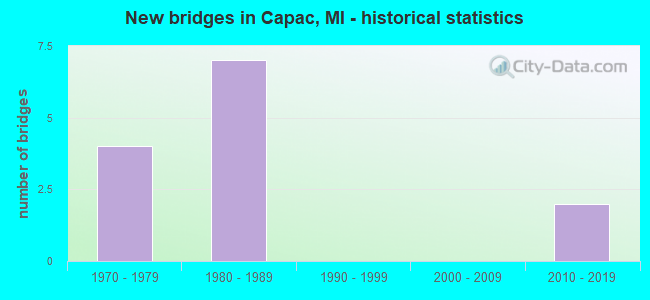
- New bridges - historical statistics
- 41970-1979
- 71980-1989
- 22010-2019


- Bridge Condition - Deck
- 14.3%Very good
- 14.3%Good
- 57.1%Satisfactory
- 14.3%Fair

- Bridge Condition - Superstructure
- 14.3%Very good
- 85.7%Good

- Bridge Condition - Substructure
- 57.1%Good
- 42.9%Satisfactory

- Bridge Condition - Channel
- 40.0%Very good
- 20.0%Good
- 40.0%Satisfactory

- Bridge Condition - Culverts
- 50.0%Very good
- 50.0%Good
Find on map >> Show street view
Structure Number: 9945, Location: 2.7 MI E OF CAPAC (Lat: 42.987192, Lng: -82.873578), Route carried "on" structure: Interstate 69, Year Built: 1982, Status: Open, Structure Length: 2.43m (7.97ft), Average Daily Traffic: 7,134 (year 2007), Truck Traffic: 22%, Average Future Daily Traffic: 9,683 (year 2018), Design Load: HS 25 or greater, Features Intersected: COX-DOTY DRAIN
Minimum Vertical Clearance: 30.48m (100.00ft), Kilometerpoint: 9.391, Lanes on structure: 2, Base Highway Network: Yes (Inventory Route: 96, Subroute: 6), Owner: State Highway Agency, Approaching Roadway Width: 13.4m (44.0ft), Skew: 1 degrees, Material/Design: Prestressed concrete, Design/Construction: Stringer/Multi-beam, Number Of Spans In Main Unit: 1, Length of Maximum Span: 24.3m (79.7ft), Curb-To-Curb Width: 13.4m (44.0ft), Out-to-Out Width: 14.6m (47.9ft)
Condition: Deck: Satisfactory, Superstructure: Good, Substructure: Good, Channel: Satisfactory, Operating Rating: 77.8 metric tons, Method Used To Determine Operating Rating: Load Factor (LF) rating reported by rating factor (RF) method using MS18 loading, Inventory Rating: 44.4 metric tons, Method Used To Determine Inventory Rating: Load Factor (LF) rating reported by rating factor (RF) method using MS18 loading, Structural Evaluation: Better than present minimum criteria, Deck Geometry: Superior to present desirable criteria, Waterway Adequacy: Equal to present desirable criteria, Approach Roadway Alignment: Equal to present desirable criteria, Designated Inspection Frequency: Every 24 months, Inspection Date: December 2021, Deck Structure Type: Concrete Cast-file-Place, Wearing Surface/Protective System: Deck Protection: Epoxy Coated Reinforcing
Find on map >> Show street view
Structure Number: 9946, Location: 2.7 MI SE OF CAPAC (Lat: 42.987528, Lng: -82.873425), Route carried "on" structure: Interstate 69, Year Built: 1982, Status: Open, Structure Length: 2.43m (7.97ft), Average Daily Traffic: 7,134 (year 2007), Truck Traffic: 22%, Average Future Daily Traffic: 9,683 (year 2018), Design Load: HS 20, Features Intersected: COX-DOTY DRAIN
Minimum Vertical Clearance: 30.48m (100.00ft), Kilometerpoint: 9.405, Lanes on structure: 2, Base Highway Network: Yes (Inventory Route: 96, Subroute: 2), Owner: State Highway Agency, Approaching Roadway Width: 13.4m (44.0ft), Skew: 1 degrees, Material/Design: Prestressed concrete, Design/Construction: Stringer/Multi-beam, Number Of Spans In Main Unit: 1, Length of Maximum Span: 24.3m (79.7ft), Curb-To-Curb Width: 13.4m (44.0ft), Out-to-Out Width: 14.6m (47.9ft)
Condition: Deck: Satisfactory, Superstructure: Good, Substructure: Good, Channel: Satisfactory, Operating Rating: 78.1 metric tons, Method Used To Determine Operating Rating: Load Factor (LF) rating reported by rating factor (RF) method using MS18 loading, Inventory Rating: 46.7 metric tons, Method Used To Determine Inventory Rating: Load Factor (LF) rating reported by rating factor (RF) method using MS18 loading, Structural Evaluation: Better than present minimum criteria, Deck Geometry: Superior to present desirable criteria, Waterway Adequacy: Better than present minimum criteria, Approach Roadway Alignment: Equal to present desirable criteria, Designated Inspection Frequency: Every 24 months, Inspection Date: December 2021, Deck Structure Type: Concrete Cast-file-Place, Wearing Surface/Protective System: Wearing Surface: Monolithic Concrete, Deck Protection: Epoxy Coated Reinforcing
Find on map >> Show street view
Structure Number: 9947, Location: 2.1 MI SW OF CAPAC (Lat: 42.993336, Lng: -82.967478), Route carried "on" structure: County highway , Year Built: 1978, Status: Open, Structure Length: 8.26m (27.10ft), Average Daily Traffic: 260 (year 1995), Truck Traffic: 2%, Average Future Daily Traffic: 299 (year 2015), Design Load: H 20, Features Intersected: I-69, Facility Carried by Structure: MARTIN ROAD
Minimum Vertical Clearance: 30.48m (100.00ft), Kilometerpoint: 0.356, Lanes on structure: 2, Lanes under structure: 4, Owner: State Highway Agency, Approaching Roadway Width: 10.3m (33.8ft), Skew: 1 degrees, Material/Design: Steel continuous, Design/Construction: Stringer/Multi-beam, Number Of Spans In Main Unit: 2, Length of Maximum Span: 43.2m (141.7ft), Curb-To-Curb Width: 11.4m (37.4ft), Out-to-Out Width: 12.1m (39.7ft)
Condition: Deck: Satisfactory, Superstructure: Good, Substructure: Satisfactory, Operating Rating: 71.6 metric tons, Method Used To Determine Operating Rating: Load Factor (LF) rating reported by rating factor (RF) method using MS18 loading, Inventory Rating: 43.1 metric tons, Method Used To Determine Inventory Rating: Load Factor (LF) rating reported by rating factor (RF) method using MS18 loading, Structural Evaluation: Equal to present minimum criteria, Deck Geometry: Superior to present desirable criteria, Underclear: Equal to present minimum criteria, Approach Roadway Alignment: Equal to present desirable criteria, Length Of Structure Improvement: 8.26m (27.10ft), Designated Inspection Frequency: Every 24 months, Inspection Date: December 2021, Bridge Improvement Cost: $223,000, Roadway Improvement Cost: $11,000, Total Project Cost: $134,000, Deck Structure Type: Concrete Cast-file-Place, Wearing Surface/Protective System: Wearing Surface: Monolithic Concrete
Find on map >> Show street view
Structure Number: 9948, Location: 2.5 MI S OF CAPAC (Lat: 42.986503, Lng: -82.927733), Route carried "on" structure: County highway 7707, Year Built: 1979, Status: Open, Structure Length: 8.23m (27.00ft), Average Daily Traffic: 5,850 (year 1990), Truck Traffic: 4%, Average Future Daily Traffic: 6,728 (year 2010), Design Load: H 20, Features Intersected: I-69, Facility Carried by Structure: CAPAC ROAD
Minimum Vertical Clearance: 30.48m (100.00ft), Kilometerpoint: 11.432, Lanes on structure: 2, Lanes under structure: 4, Owner: State Highway Agency, Approaching Roadway Width: 12.2m (40.0ft), Material/Design: Steel continuous, Design/Construction: Stringer/Multi-beam, Number Of Spans In Main Unit: 2, Length of Maximum Span: 41.7m (136.8ft), Curb-To-Curb Width: 13.1m (43.0ft), Out-to-Out Width: 13.9m (45.6ft)
Condition: Deck: Fair, Superstructure: Good, Substructure: Satisfactory, Operating Rating: 77.4 metric tons, Method Used To Determine Operating Rating: Load Factor (LF) rating reported by rating factor (RF) method using MS18 loading, Inventory Rating: 46.3 metric tons, Method Used To Determine Inventory Rating: Load Factor (LF) rating reported by rating factor (RF) method using MS18 loading, Structural Evaluation: Equal to present minimum criteria, Deck Geometry: Somewhat better than minimum adequacy, Underclear: Somewhat better than minimum adequacy, Approach Roadway Alignment: Equal to present desirable criteria, Designated Inspection Frequency: Every 24 months, Inspection Date: December 2021, Deck Structure Type: Concrete Cast-file-Place, Wearing Surface/Protective System: Wearing Surface: Monolithic Concrete
Find on map >> Show street view
Structure Number: 9949, Location: 5 MI SE OF CAPAC (Lat: 42.987286, Lng: -82.868589), Route carried "on" structure: County highway , Year Built: 1982, Status: Open, Structure Length: 8.20m (26.90ft), Average Daily Traffic: 80 (year 1987), Truck Traffic: 2%, Average Future Daily Traffic: 92 (year 2007), Design Load: HS 20, Features Intersected: I-69, Facility Carried by Structure: MILLER RD
Minimum Vertical Clearance: 30.48m (100.00ft), Kilometerpoint: 0.364, Lanes on structure: 2, Lanes under structure: 4, Owner: State Highway Agency, Approaching Roadway Width: 10.3m (33.8ft), Material/Design: Steel continuous, Design/Construction: Stringer/Multi-beam, Number Of Spans In Main Unit: 2, Length of Maximum Span: 41.1m (134.8ft), Curb-To-Curb Width: 11.0m (36.1ft), Out-to-Out Width: 12.2m (40.0ft)
Condition: Deck: Satisfactory, Superstructure: Good, Substructure: Good, Operating Rating: 69.0 metric tons, Method Used To Determine Operating Rating: Load Factor (LF) rating reported by rating factor (RF) method using MS18 loading, Inventory Rating: 41.5 metric tons, Method Used To Determine Inventory Rating: Load Factor (LF) rating reported by rating factor (RF) method using MS18 loading, Structural Evaluation: Better than present minimum criteria, Deck Geometry: Superior to present desirable criteria, Underclear: Somewhat better than minimum adequacy, Approach Roadway Alignment: Equal to present desirable criteria, Designated Inspection Frequency: Every 24 months, Inspection Date: November 2021, Deck Structure Type: Concrete Cast-file-Place, Wearing Surface/Protective System: Wearing Surface: Epoxy Overlay, Deck Protection: Epoxy Coated Reinforcing
Find on map >> Show street view
Structure Number: 995, Location: 6.0 MI SE OF CAPAC (Lat: 42.984303, Lng: -82.851814), Route carried "on" structure: County highway , Year Built: 1982, Status: Open, Structure Length: 14.54m (47.70ft), Average Daily Traffic: 450 (year 1987), Truck Traffic: 2%, Average Future Daily Traffic: 518 (year 2007), Design Load: HS 20, Features Intersected: I-69, Facility Carried by Structure: BURT RD
Minimum Vertical Clearance: 30.48m (100.00ft), Kilometerpoint: 10.925, Lanes on structure: 2, Lanes under structure: 4, Owner: State Highway Agency, Approaching Roadway Width: 13.4m (44.0ft), Skew: 5 degrees, Material/Design: Steel continuous, Design/Construction: Stringer/Multi-beam, Number Of Spans In Main Unit: 2, Length of Maximum Span: 72.2m (236.9ft), Curb-To-Curb Width: 12.8m (42.0ft), Out-to-Out Width: 14.0m (45.9ft)
Condition: Deck: Good, Superstructure: Good, Substructure: Satisfactory, Operating Rating: 51.5 metric tons, Method Used To Determine Operating Rating: Load Factor (LF) rating reported by rating factor (RF) method using MS18 loading, Inventory Rating: 30.8 metric tons, Method Used To Determine Inventory Rating: Load Factor (LF) rating reported by rating factor (RF) method using MS18 loading, Structural Evaluation: Equal to present minimum criteria, Deck Geometry: Superior to present desirable criteria, Underclear: Somewhat better than minimum adequacy, Approach Roadway Alignment: Equal to present desirable criteria, Designated Inspection Frequency: Every 24 months, Inspection Date: November 2021, Deck Structure Type: Concrete Cast-file-Place, Wearing Surface/Protective System: Wearing Surface: Epoxy Overlay, Deck Protection: Epoxy Coated Reinforcing
Find on map >> Show street view
Structure Number: 1008, Location: SEC. 9 BERLIN TWP. (Lat: 42.964386, Lng: -82.937767), Route carried "on" structure: County highway 7707, Year Built: 1984, Year Reconstructed: 2014, Status: Open, Structure Length: 2.93m (9.61ft), Average Daily Traffic: 5,800 (year 2012), Truck Traffic: 8%, Average Future Daily Traffic: 8,620 (year 2032), Design Load: Greater than HL93, Features Intersected: BELLE RIVER, Facility Carried by Structure: CAPAC ROAD
Minimum Vertical Clearance: 30.48m (100.00ft), Kilometerpoint: 8.811, Lanes on structure: 2, Base Highway Network: Yes (Inventory Route: 421, Subroute: 3), Owner: County Highway Agency, Approaching Roadway Width: 11.0m (36.1ft), Skew: 1 degrees, Material/Design: Prestressed concrete, Design/Construction: Stringer/Multi-beam, Number Of Spans In Main Unit: 3, Length of Maximum Span: 9.7m (31.8ft), Curb-To-Curb Width: 12.2m (40.0ft), Out-to-Out Width: 13.2m (43.3ft)
Condition: Deck: Very good, Superstructure: Very good, Substructure: Good, Channel: Good, Operating Rating: 66.4 metric tons, Method Used To Determine Operating Rating: Load and Resistance Factor Rating (LRFR) rating reported by rating factor(RF) method using HL-93 loadings, Inventory Rating: 50.5 metric tons, Method Used To Determine Inventory Rating: Load and Resistance Factor Rating (LRFR) rating reported by rating factor(RF) method using HL-93 loadings, Structural Evaluation: Better than present minimum criteria, Deck Geometry: Somewhat better than minimum adequacy, Waterway Adequacy: Equal to present desirable criteria, Approach Roadway Alignment: Equal to present desirable criteria, Designated Inspection Frequency: Every 24 months, Inspection Date: November 2020, Deck Structure Type: Concrete Cast-file-Place, Wearing Surface/Protective System: Wearing Surface: Monolithic Concrete, Deck Protection: Epoxy Coated Reinforcing
Find on map >> Show street view
Structure Number: 10114, Location: SEC 12 BERLIN TWP (Lat: 42.962678, Lng: -82.872289), Route carried "on" structure: ServiceCounty highway , Year Built: 2011, Status: Open, Structure Length: 1.10m (3.61ft), Average Daily Traffic: 105 (year 1994), Average Future Daily Traffic: 120 (year 2014), Features Intersected: COX-DOTY DRAIN, Facility Carried by Structure: HUNT ROAD
Minimum Vertical Clearance: 30.48m (100.00ft), Kilometerpoint: 2.746, Lanes on structure: 2, Owner: County Highway Agency, Approaching Roadway Width: 5.4m (17.7ft), Material/Design: Concrete, Design/Construction: Culvert, Number Of Spans In Main Unit: 1, Length of Maximum Span: 11.0m (36.1ft), Curb-To-Curb Width: 9.3m (30.5ft), Out-to-Out Width: 9.8m (32.2ft)
Condition: Channel: Very good, Culverts: Good, Operating Rating: 62.2 metric tons, Method Used To Determine Operating Rating: Load and Resistance Factor Rating (LRFR) rating reported by rating factor(RF) method using HL-93 loadings, Inventory Rating: 48.0 metric tons, Method Used To Determine Inventory Rating: Load and Resistance Factor Rating (LRFR) rating reported by rating factor(RF) method using HL-93 loadings, Structural Evaluation: Better than present minimum criteria, Deck Geometry: Equal to present minimum criteria, Waterway Adequacy: Better than present minimum criteria, Approach Roadway Alignment: Equal to present minimum criteria, Designated Inspection Frequency: Every 24 months, Inspection Date: January 2021, Deck Structure Type: Concrete Precast Panels, Wearing Surface/Protective System: Wearing Surface: Gravel
Find on map >> Show street view
Structure Number: 13871, Location: 340 FT S OF DONALD ROAD (Lat: 42.997083, Lng: -82.928111), Route carried "on" structure: County highway , Year Built: 2015, Status: Open, Structure Length: 0.63m (2.07ft), Average Daily Traffic: 7,208 (year 2014), Truck Traffic: 19%, Average Future Daily Traffic: 10,753 (year 2034), Design Load: Greater than HL93, Features Intersected: CAPAC DRAIN, Facility Carried by Structure: CAPAC ROAD
Minimum Vertical Clearance: 30.48m (100.00ft), Kilometerpoint: 12.606, Lanes on structure: 2, Owner: County Highway Agency, Approaching Roadway Width: 11.0m (36.1ft), Skew: 1 degrees, Material/Design: Aluminum, Iron, Design/Construction: Culvert, Number Of Spans In Main Unit: 1, Length of Maximum Span: 6.3m (20.7ft), Curb-To-Curb Width: 12.2m (40.0ft), Out-to-Out Width: 16.6m (54.5ft)
Condition: Channel: Very good, Culverts: Very good, Operating Rating: 97.2 metric tons, Method Used To Determine Operating Rating: Load and Resistance Factor Rating (LRFR) rating reported by rating factor(RF) method using HL-93 loadings, Inventory Rating: 97.2 metric tons, Method Used To Determine Inventory Rating: Load and Resistance Factor Rating (LRFR) rating reported by rating factor(RF) method using HL-93 loadings, Structural Evaluation: Equal to present desirable criteria, Deck Geometry: Somewhat better than minimum adequacy, Waterway Adequacy: Better than present minimum criteria, Approach Roadway Alignment: Equal to present desirable criteria, Designated Inspection Frequency: Every 24 months, Inspection Date: January 2022, Wearing Surface/Protective System: Wearing Surface: Bituminous
Find on map >> Show street view
Structure Number: 9947, Location: 2.1 MI SW OF CAPAC (Lat: 42.993336, Lng: -82.967478), Route carried "under" structure: Interstate 69, Year Built: 1978, Structure Length: 0. m, Average Daily Traffic: 13,836 (year 2007), Truck Traffic: 24%, Features Intersected: I-69, Facility Carried by Structure: MARTIN ROAD
Minimum Vertical Clearance: 5.23m (17.16ft), Kilometerpoint: 1.642, Lanes on structure: 2, Lanes under structure: 4, Material/Design: Steel continuous, Design/Construction: Stringer/Multi-beam, Length of Maximum Span: 43.2m (141.7ft)
Find on map >> Show street view
Structure Number: 9948, Location: 2.5 MI S OF CAPAC (Lat: 42.986503, Lng: -82.927733), Route carried "under" structure: Interstate 69, Year Built: 1979, Structure Length: 0. m, Average Daily Traffic: 14,268 (year 2007), Truck Traffic: 22%, Features Intersected: I-69, Facility Carried by Structure: CAPAC ROAD
Minimum Vertical Clearance: 5.18m (16.99ft), Kilometerpoint: 4.973, Lanes on structure: 2, Lanes under structure: 4, Material/Design: Steel continuous, Design/Construction: Stringer/Multi-beam, Length of Maximum Span: 41.7m (136.8ft)
Find on map >> Show street view
Structure Number: 9949, Location: 5 MI SE OF CAPAC (Lat: 42.987286, Lng: -82.868589), Route carried "under" structure: Interstate 69, Year Built: 1982, Structure Length: 0. m, Average Daily Traffic: 14,268 (year 2007), Truck Traffic: 22%, Features Intersected: I-69, Facility Carried by Structure: MILLER RD
Minimum Vertical Clearance: 5.33m (17.49ft), Kilometerpoint: 9.798, Lanes on structure: 2, Lanes under structure: 4, Material/Design: Steel continuous, Design/Construction: Stringer/Multi-beam, Length of Maximum Span: 41.1m (134.8ft)
Find on map >> Show street view
Structure Number: 995, Location: 6.0 MI SE OF CAPAC (Lat: 42.984303, Lng: -82.851814), Route carried "under" structure: Interstate 69, Year Built: 1982, Structure Length: 0. m, Average Daily Traffic: 19,000 (year 2009), Truck Traffic: 22%, Features Intersected: I-69, Facility Carried by Structure: BURT RD
Minimum Vertical Clearance: 5.18m (16.99ft), Kilometerpoint: 11.171, Lanes on structure: 2, Lanes under structure: 4, Material/Design: Steel continuous, Design/Construction: Stringer/Multi-beam, Length of Maximum Span: 72.2m (236.9ft)