Bridge Statistics for Canton, New York (NY)
Condition, Traffic, Stress, Structural Evaluation, Project Costs
- National Bridge Inventory (NBI) Statistics
- 17Number of bridges
- 148ft / 45.2mTotal length
- $22,605,000Total costs
- 65,819Total average daily traffic
- 4,076Total average daily truck traffic
- National Bridge Inventory (NBI) Registered Bridges for Canton
- No street view available for this location
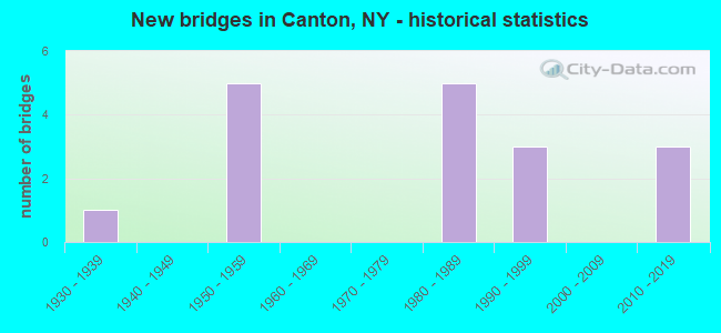
- New bridges - historical statistics
- 11930-1939
- 51950-1959
- 51980-1989
- 31990-1999
- 32010-2019
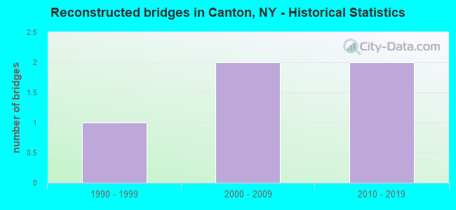
- Reconstructed bridges - Historical Statistics
- 11990-1999
- 22000-2009
- 22010-2019
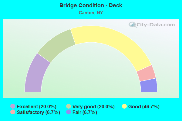
- Bridge Condition - Deck
- 20.0%Excellent
- 20.0%Very good
- 46.7%Good
- 6.7%Satisfactory
- 6.7%Fair
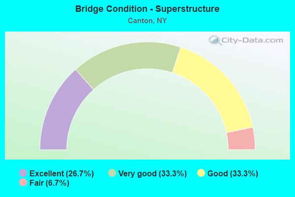
- Bridge Condition - Superstructure
- 26.7%Excellent
- 33.3%Very good
- 33.3%Good
- 6.7%Fair
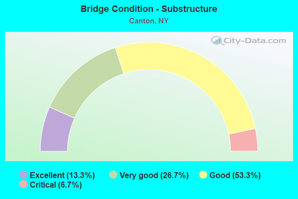
- Bridge Condition - Substructure
- 13.3%Excellent
- 26.7%Very good
- 53.3%Good
- 6.7%Critical
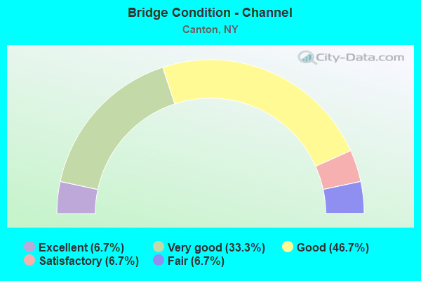
- Bridge Condition - Channel
- 6.7%Excellent
- 33.3%Very good
- 46.7%Good
- 6.7%Satisfactory
- 6.7%Fair
Find on map >> Show street view
Structure Number: 100877, Location: VIL CANTON-.1 MI E JCT68W (Lat: 44.595131, Lng: -75.175078), Route carried "on" structure: State highway 11, Year Built: 1981, Year Reconstructed: 2017, Status: Open, Structure Length: 4.36m (14.30ft), Average Daily Traffic: 13,965 (year 2014), Truck Traffic: 8%, Average Future Daily Traffic: 14,030 (year 2040), Design Load: HS 20, Features Intersected: GRASSE RIVER
Minimum Vertical Clearance: 30+ m (98+ ft), Kilometerpoint: 49.139, Lanes on structure: 4, Base Highway Network: Yes, Owner: State Highway Agency, Approaching Roadway Width: 17.7m (58.1ft), Skew: 22 degrees, Material/Design: Steel, Design/Construction: Stringer/Multi-beam, Number Of Spans In Main Unit: 1, Length of Maximum Span: 42.6m (139.8ft), Curb or Sidewalk Widths: Left: 1.5m (4.9ft), Right: 1.5m (4.9ft), Curb-To-Curb Width: 17.8m (58.4ft), Out-to-Out Width: 21.3m (69.9ft)
Condition: Deck: Very good, Superstructure: Very good, Substructure: Good, Channel: Very good, Inventory Rating: 71.7 metric tons, Method Used To Determine Inventory Rating: Load Factor (LF), Structural Evaluation: Better than present minimum criteria, Deck Geometry: Somewhat better than minimum adequacy, Waterway Adequacy: Equal to present minimum criteria, Approach Roadway Alignment: Equal to present desirable criteria, Length Of Structure Improvement: 4.35m (14.27ft), Designated Inspection Frequency: Every 24 months, Inspection Date: July 2021, Bridge Improvement Cost: $2,157,000, Roadway Improvement Cost: $1,263,000, Total Project Cost: $3,421,000 ( Estimate for 2021), Deck Structure Type: Concrete Cast-file-Place, Wearing Surface/Protective System: Wearing Surface: Integral Concrete, Deck Protection: Epoxy Coated Reinforcing
Find on map >> Show street view
Structure Number: 100878, Location: VIL CANTON-.3 MI E JCT68W (Lat: 44.595247, Lng: -75.173842), Route carried "on" structure: US 11, Year Built: 1981, Year Reconstructed: 2017, Status: Open, Structure Length: 6.98m (22.90ft), Average Daily Traffic: 13,965 (year 2014), Truck Traffic: 8%, Average Future Daily Traffic: 14,030 (year 2040), Design Load: HS 20, Features Intersected: GRASSE RIVER
Minimum Vertical Clearance: 30+ m (98+ ft), Kilometerpoint: 49.251, Lanes on structure: 4, Base Highway Network: Yes, Owner: State Highway Agency, Approaching Roadway Width: 17.7m (58.1ft), Skew: 21 degrees, Material/Design: Steel continuous, Design/Construction: Stringer/Multi-beam, Number Of Spans In Main Unit: 2, Length of Maximum Span: 34.4m (112.9ft), Curb or Sidewalk Widths: Left: 1.5m (4.9ft), Right: 1.5m (4.9ft), Curb-To-Curb Width: 17.8m (58.4ft), Out-to-Out Width: 21.3m (69.9ft)
Condition: Deck: Very good, Superstructure: Very good, Substructure: Very good, Channel: Very good, Operating Rating: 76.2 metric tons, Method Used To Determine Operating Rating: Load Factor (LF), Inventory Rating: 45.4 metric tons, Method Used To Determine Inventory Rating: Load Factor (LF), Structural Evaluation: Equal to present desirable criteria, Deck Geometry: Somewhat better than minimum adequacy, Waterway Adequacy: Equal to present minimum criteria, Approach Roadway Alignment: Equal to present desirable criteria, Length Of Structure Improvement: 6.97m (22.87ft), Designated Inspection Frequency: Every 24 months, Inspection Date: July 2021, Bridge Improvement Cost: $3,010,000, Roadway Improvement Cost: $1,763,000, Total Project Cost: $4,772,000 ( Estimate for 2021), Deck Structure Type: Concrete Cast-file-Place, Wearing Surface/Protective System: Wearing Surface: Integral Concrete, Deck Protection: Epoxy Coated Reinforcing
Find on map >> Show street view
Structure Number: 10088, Location: 3.5 MI NE JCT US11 &SH310 (Lat: 44.626194, Lng: -75.092617), Route carried "on" structure: US 11, Year Built: 1981, Year Reconstructed: 2006, Status: Open, Structure Length: 1.34m (4.40ft), Average Daily Traffic: 7,828 (year 2020), Truck Traffic: 9%, Average Future Daily Traffic: 7,902 (year 2040), Design Load: HL 93, Features Intersected: TROUT BROOK
Minimum Vertical Clearance: 30+ m (98+ ft), Kilometerpoint: 56.782, Lanes on structure: 2, Base Highway Network: Yes, Owner: State Highway Agency, Approaching Roadway Width: 13.4m (44.0ft), Material/Design: Prestressed concrete, Design/Construction: Box Beam or Girders - Multiple, Number Of Spans In Main Unit: 1, Length of Maximum Span: 12.3m (40.4ft), Curb-To-Curb Width: 13.4m (44.0ft), Out-to-Out Width: 14.0m (45.9ft)
Condition: Deck: Good, Superstructure: Excellent, Substructure: Good, Channel: Good, Operating Rating: 83.5 metric tons, Method Used To Determine Operating Rating: Load Factor (LF), Inventory Rating: 49.0 metric tons, Method Used To Determine Inventory Rating: Load Factor (LF), Structural Evaluation: Better than present minimum criteria, Deck Geometry: Equal to present minimum criteria, Waterway Adequacy: Somewhat better than minimum adequacy, Approach Roadway Alignment: Equal to present desirable criteria, Length Of Structure Improvement: 1.34m (4.40ft), Designated Inspection Frequency: Every 24 months, Inspection Date: July 2020, Bridge Improvement Cost: $531,000, Roadway Improvement Cost: $311,000, Total Project Cost: $843,000 ( Estimate for 2021), Wearing Surface/Protective System: Wearing Surface: Monolithic Concrete
Find on map >> Show street view
Structure Number: 102931, Location: 0.6 MI SE JCT RTS 68 + 11 (Lat: 44.591750, Lng: -75.137581), Route carried "on" structure: State highway 68, Year Built: 1959, Status: Open, Structure Length: 0.98m (3.22ft), Average Daily Traffic: 1,696 (year 2020), Truck Traffic: 6%, Average Future Daily Traffic: 2,060 (year 2040), Design Load: H 20, Features Intersected: TRACY BROOK
Minimum Vertical Clearance: 30+ m (98+ ft), Kilometerpoint: 35.398, Lanes on structure: 2, Base Highway Network: Yes, Owner: State Highway Agency, Approaching Roadway Width: 7.9m (25.9ft), Material/Design: Concrete, Design/Construction: Slab, Number Of Spans In Main Unit: 1, Length of Maximum Span: 9.1m (29.9ft), Curb-To-Curb Width: 8.6m (28.2ft), Out-to-Out Width: 9.6m (31.5ft)
Condition: Deck: Good, Superstructure: Good, Substructure: Good, Channel: Good, Operating Rating: 46.7 metric tons, Method Used To Determine Operating Rating: Load and Resistance Factor Rating (LRFR) rating reported by rating factor(RF) method using HL-93 loadings, Inventory Rating: 36.0 metric tons, Method Used To Determine Inventory Rating: Load and Resistance Factor Rating (LRFR) rating reported by rating factor(RF) method using HL-93 loadings, Structural Evaluation: Better than present minimum criteria, Deck Geometry: Somewhat better than minimum adequacy, Waterway Adequacy: Equal to present desirable criteria, Approach Roadway Alignment: Meets minimum limits, Length Of Structure Improvement: 0.97m (3.18ft), Designated Inspection Frequency: Every 24 months, Inspection Date: May 2020, Bridge Improvement Cost: $419,000, Roadway Improvement Cost: $245,000, Total Project Cost: $664,000 ( Estimate for 2021), Deck Structure Type: Concrete Cast-file-Place, Wearing Surface/Protective System: Wearing Surface: Bituminous
Find on map >> Show street view
Structure Number: 102932, Location: 2.0 MI SE JCT RTS 68 + 11 (Lat: 44.581683, Lng: -75.117422), Route carried "on" structure: State highway 68, Year Built: 1959, Year Reconstructed: 2012, Status: Open, Structure Length: 1.52m (4.99ft), Average Daily Traffic: 1,696 (year 2020), Truck Traffic: 6%, Average Future Daily Traffic: 1,706 (year 2040), Design Load: H 20, Features Intersected: GRANNIS BROOK
Minimum Vertical Clearance: 30+ m (98+ ft), Kilometerpoint: 37.377, Lanes on structure: 2, Base Highway Network: Yes, Owner: State Highway Agency, Approaching Roadway Width: 8.8m (28.9ft), Skew: 3 degrees, Material/Design: Steel, Design/Construction: Stringer/Multi-beam, Number Of Spans In Main Unit: 1, Length of Maximum Span: 14.6m (47.9ft), Curb-To-Curb Width: 9.1m (29.9ft), Out-to-Out Width: 10.1m (33.1ft)
Condition: Deck: Good, Superstructure: Very good, Substructure: Good, Channel: Good, Inventory Rating: 64.4 metric tons, Method Used To Determine Inventory Rating: Load Factor (LF), Structural Evaluation: Better than present minimum criteria, Deck Geometry: Somewhat better than minimum adequacy, Waterway Adequacy: Somewhat better than minimum adequacy, Approach Roadway Alignment: Meets minimum limits, Length Of Structure Improvement: 1.52m (4.99ft), Designated Inspection Frequency: Every 24 months, Inspection Date: September 2020, Bridge Improvement Cost: $679,000, Roadway Improvement Cost: $398,000, Total Project Cost: $1,077,000 ( Estimate for 2021), Deck Structure Type: Concrete Cast-file-Place, Wearing Surface/Protective System: Wearing Surface: Integral Concrete, Deck Protection: Epoxy Coated Reinforcing
Find on map >> Show street view
Structure Number: 102933, Location: 4.3 MI SE JCT RTS 68 + 11 (Lat: 44.572486, Lng: -75.086458), Route carried "on" structure: State highway 68, Year Built: 1959, Status: Open, Structure Length: 0.98m (3.22ft), Average Daily Traffic: 1,696 (year 2020), Truck Traffic: 6%, Average Future Daily Traffic: 1,706 (year 2040), Design Load: H 20, Features Intersected: BOYDEN BROOK
Minimum Vertical Clearance: 30+ m (98+ ft), Kilometerpoint: 40.193, Lanes on structure: 2, Base Highway Network: Yes, Owner: State Highway Agency, Approaching Roadway Width: 7.6m (24.9ft), Material/Design: Concrete, Design/Construction: Slab, Number Of Spans In Main Unit: 1, Length of Maximum Span: 9.1m (29.9ft), Curb-To-Curb Width: 8.5m (27.9ft), Out-to-Out Width: 9.5m (31.2ft)
Condition: Deck: Good, Superstructure: Good, Substructure: Good, Channel: Good, Operating Rating: 37.3 metric tons, Method Used To Determine Operating Rating: Load and Resistance Factor Rating (LRFR) rating reported by rating factor(RF) method using HL-93 loadings, Inventory Rating: 28.8 metric tons, Method Used To Determine Inventory Rating: Load and Resistance Factor Rating (LRFR) rating reported by rating factor(RF) method using HL-93 loadings, Structural Evaluation: Better than present minimum criteria, Deck Geometry: Somewhat better than minimum adequacy, Waterway Adequacy: Equal to present minimum criteria, Approach Roadway Alignment: Meets minimum limits, Length Of Structure Improvement: 0.97m (3.18ft), Designated Inspection Frequency: Every 24 months, Inspection Date: April 2020, Bridge Improvement Cost: $338,000, Roadway Improvement Cost: $198,000, Total Project Cost: $535,000 ( Estimate for 2021), Wearing Surface/Protective System: Wearing Surface: Bituminous, Membrane: Other
Find on map >> Show street view
Structure Number: 222161, Location: 4.0 MI NW OF CRARY MILLS (Lat: 44.629439, Lng: -75.082928), Route carried "on" structure: Other road , Year Built: 1950, Status: Posted for load, Structure Length: 0.79m (2.59ft), Average Daily Traffic: 283 (year 2016), Truck Traffic: 5%, Average Future Daily Traffic: 396 (year 2036), Features Intersected: TROUT BROOK, Facility Carried by Structure: AMES ROAD
Minimum Vertical Clearance: 30+ m (98+ ft), Kilometerpoint: 4.409, Lanes on structure: 2, Owner: Town or Township Highway Agency, Approaching Roadway Width: 5.2m (17.1ft), Material/Design: Steel, Design/Construction: Girder and Floorbeam System, Number Of Spans In Main Unit: 1, Length of Maximum Span: 6.7m (22.0ft), Curb-To-Curb Width: 6.8m (22.3ft), Out-to-Out Width: 7.1m (23.3ft)
Condition: Deck: Fair, Superstructure: Fair, Substructure: Critical, Channel: Fair, Operating Rating: 30.8 metric tons, Method Used To Determine Operating Rating: Load Factor (LF), Inventory Rating: 17.2 metric tons, Method Used To Determine Inventory Rating: Load Factor (LF), Structural Evaluation: High priority of replacement, Deck Geometry: Meets minimum limits, Waterway Adequacy: Better than present minimum criteria, Approach Roadway Alignment: Somewhat better than minimum adequacy, Bridge Posting: Required (Relationship of Operating Rating to Maximum Legal Load: > 39.9% below), Length Of Structure Improvement: 0.76m (2.49ft), Designated Inspection Frequency: Every 12 months, Inspection Date: April 2021, Bridge Improvement Cost: $193,000, Roadway Improvement Cost: $113,000, Total Project Cost: $305,000 ( Estimate for 2021), Deck Structure Type: Concrete Cast-file-Place, Wearing Surface/Protective System: Wearing Surface: Bituminous
Find on map >> Show street view
Structure Number: 322094, Location: 1.2 MI EAST OF CANTON (Lat: 44.586664, Lng: -75.131556), Route carried "on" structure: Other road , Year Built: 2011, Status: Open, Structure Length: 2.83m (9.28ft), Average Daily Traffic: 2,424 (year 2018), Truck Traffic: 8%, Average Future Daily Traffic: 3,394 (year 2038), Design Load: HL 93, Features Intersected: LITTLE RIVER, Facility Carried by Structure: PIKE ROAD
Minimum Vertical Clearance: 30+ m (98+ ft), Kilometerpoint: 16.154, Lanes on structure: 2, Owner: County Highway Agency, Approaching Roadway Width: 11.6m (38.1ft), Material/Design: Prestressed concrete, Design/Construction: Box Beam or Girders - Multiple, Number Of Spans In Main Unit: 1, Length of Maximum Span: 26.8m (87.9ft), Curb-To-Curb Width: 9.2m (30.2ft), Out-to-Out Width: 10.2m (33.5ft)
Condition: Deck: Excellent, Superstructure: Excellent, Substructure: Very good, Channel: Very good, Operating Rating: 88.0 metric tons, Method Used To Determine Operating Rating: Load Factor (LF), Inventory Rating: 70.8 metric tons, Method Used To Determine Inventory Rating: Load Factor (LF), Structural Evaluation: Equal to present desirable criteria, Deck Geometry: Meets minimum limits, Waterway Adequacy: Equal to present desirable criteria, Approach Roadway Alignment: Equal to present desirable criteria, Length Of Structure Improvement: 2.83m (9.28ft), Designated Inspection Frequency: Every 24 months, Inspection Date: July 2021, Bridge Improvement Cost: $578,000, Roadway Improvement Cost: $338,000, Total Project Cost: $916,000 ( Estimate for 2021), Wearing Surface/Protective System: Wearing Surface: Bituminous, Membrane: Other
Find on map >> Show street view
Structure Number: 334062, Location: .3 MI NW OF PYRITES (Lat: 44.523394, Lng: -75.192728), Route carried "on" structure: County highway , Year Built: 1994, Status: Open, Structure Length: 4.45m (14.60ft), Average Daily Traffic: 1,101 (year 2019), Truck Traffic: 8%, Average Future Daily Traffic: 1,541 (year 2039), Design Load: HS 25 or greater, Features Intersected: GRASSE RIVER, Facility Carried by Structure: CO RD 21
Minimum Vertical Clearance: 30+ m (98+ ft), Kilometerpoint: 6.661, Lanes on structure: 2, Owner: County Highway Agency, Approaching Roadway Width: 9.1m (29.9ft), Material/Design: Steel, Design/Construction: Stringer/Multi-beam, Number Of Spans In Main Unit: 1, Length of Maximum Span: 43.2m (141.7ft), Curb-To-Curb Width: 9.1m (29.9ft), Out-to-Out Width: 9.8m (32.2ft)
Condition: Deck: Very good, Superstructure: Very good, Substructure: Very good, Channel: Very good, Operating Rating: 83.5 metric tons, Method Used To Determine Operating Rating: Load Factor (LF), Inventory Rating: 49.9 metric tons, Method Used To Determine Inventory Rating: Load Factor (LF), Structural Evaluation: Equal to present desirable criteria, Deck Geometry: Somewhat better than minimum adequacy, Waterway Adequacy: Better than present minimum criteria, Approach Roadway Alignment: Equal to present desirable criteria, Length Of Structure Improvement: 4.45m (14.60ft), Designated Inspection Frequency: Every 24 months, Inspection Date: May 2020, Bridge Improvement Cost: $1,028,000, Roadway Improvement Cost: $602,000, Total Project Cost: $1,629,000 ( Estimate for 2021), Deck Structure Type: Concrete Cast-file-Place, Wearing Surface/Protective System: Wearing Surface: Bituminous, Deck Protection: Epoxy Coated Reinforcing
Find on map >> Show street view
Structure Number: 334063, Location: 3 MI SE OF CANTON (Lat: 44.556322, Lng: -75.113406), Route carried "on" structure: County highway , Year Built: 1986, Year Reconstructed: 1997, Status: Open, Structure Length: 2.74m (8.99ft), Average Daily Traffic: 1,811 (year 2018), Truck Traffic: 6%, Average Future Daily Traffic: 1,889 (year 2040), Design Load: HS 25 or greater, Features Intersected: LITTLE RIVER, Facility Carried by Structure: CR 27, FINE CTN L
Minimum Vertical Clearance: 30+ m (98+ ft), Kilometerpoint: 40.145, Lanes on structure: 2, Owner: County Highway Agency, Approaching Roadway Width: 6.1m (20.0ft), Material/Design: Steel, Design/Construction: Stringer/Multi-beam, Number Of Spans In Main Unit: 1, Length of Maximum Span: 26.5m (86.9ft), Curb-To-Curb Width: 9.2m (30.2ft), Out-to-Out Width: 10.1m (33.1ft)
Condition: Deck: Satisfactory, Superstructure: Good, Substructure: Good, Channel: Satisfactory, Operating Rating: 60.6 metric tons, Method Used To Determine Operating Rating: Load and Resistance Factor Rating (LRFR) rating reported by rating factor(RF) method using HL-93 loadings, Inventory Rating: 46.7 metric tons, Method Used To Determine Inventory Rating: Load and Resistance Factor Rating (LRFR) rating reported by rating factor(RF) method using HL-93 loadings, Structural Evaluation: Better than present minimum criteria, Deck Geometry: Somewhat better than minimum adequacy, Waterway Adequacy: Somewhat better than minimum adequacy, Approach Roadway Alignment: Equal to present minimum criteria, Length Of Structure Improvement: 2.74m (8.99ft), Designated Inspection Frequency: Every 24 months, Inspection Date: July 2021, Bridge Improvement Cost: $689,000, Roadway Improvement Cost: $404,000, Total Project Cost: $1,093,000 ( Estimate for 2021), Deck Structure Type: Concrete Cast-file-Place, Wearing Surface/Protective System: Wearing Surface: Bituminous, Deck Protection: Epoxy Coated Reinforcing
Find on map >> Show street view
Structure Number: 334064, Location: 0.2 MI SE OF CANTON (Lat: 44.584292, Lng: -75.158117), Route carried "on" structure: County highway , Year Built: 1994, Status: Open, Structure Length: 4.24m (13.91ft), Average Daily Traffic: 3,702 (year 2019), Truck Traffic: 8%, Average Future Daily Traffic: 3,861 (year 2040), Design Load: HS 25 or greater, Features Intersected: LITTLE RIVER, Facility Carried by Structure: CR27FNE-CNTN-LSBN
Minimum Vertical Clearance: 5.48m (17.98ft), Kilometerpoint: 44.988, Lanes on structure: 2, Owner: County Highway Agency, Approaching Roadway Width: 10.4m (34.1ft), Material/Design: Wood or Timber, Design/Construction: Arch - Thru, Number Of Spans In Main Unit: 1, Length of Maximum Span: 38.7m (127.0ft), Curb or Sidewalk Widths: Left: 1.5m (4.9ft), Right: 1.5m (4.9ft), Curb-To-Curb Width: 9.9m (32.5ft), Out-to-Out Width: 10.1m (33.1ft)
Condition: Deck: Good, Superstructure: Good, Substructure: Very good, Channel: Very good, Operating Rating: 58.1 metric tons, Method Used To Determine Operating Rating: Load Factor (LF), Inventory Rating: 40.8 metric tons, Method Used To Determine Inventory Rating: Load Factor (LF), Structural Evaluation: Better than present minimum criteria, Deck Geometry: Meets minimum limits, Waterway Adequacy: Equal to present desirable criteria, Approach Roadway Alignment: Equal to present desirable criteria, Length Of Structure Improvement: 4.23m (13.88ft), Designated Inspection Frequency: Every 24 months, Critical Feature Inspection Frequency: Every 24 months, Inspection Date: August 2020, Critical Feature Inspection Date: August 2020, Bridge Improvement Cost: $2,095,000, Roadway Improvement Cost: $1,227,000, Total Project Cost: $3,321,000 ( Estimate for 2021), Deck Structure Type: Wood or Timber, Wearing Surface/Protective System: Wearing Surface: Bituminous
Find on map >> Show street view
Structure Number: 334065, Location: 2 MI NE OF CANTON (Lat: 44.610394, Lng: -75.117628), Route carried "on" structure: Other road , Year Built: 1959, Status: Open, Structure Length: 0.94m (3.08ft), Average Daily Traffic: 609 (year 2018), Truck Traffic: 6%, Average Future Daily Traffic: 853 (year 2038), Features Intersected: TRACY BROOK, Facility Carried by Structure: COWAN ROAD
Minimum Vertical Clearance: 30+ m (98+ ft), Kilometerpoint: 2.848, Lanes on structure: 2, Owner: County Highway Agency, Approaching Roadway Width: 5.2m (17.1ft), Material/Design: Steel, Design/Construction: Stringer/Multi-beam, Number Of Spans In Main Unit: 1, Length of Maximum Span: 8.8m (28.9ft), Curb-To-Curb Width: 7.1m (23.3ft), Out-to-Out Width: 7.9m (25.9ft)
Condition: Deck: Good, Superstructure: Good, Substructure: Good, Channel: Good, Operating Rating: 36.6 metric tons, Method Used To Determine Operating Rating: Load and Resistance Factor Rating (LRFR) rating reported by rating factor(RF) method using HL-93 loadings, Inventory Rating: 28.2 metric tons, Method Used To Determine Inventory Rating: Load and Resistance Factor Rating (LRFR) rating reported by rating factor(RF) method using HL-93 loadings, Structural Evaluation: Better than present minimum criteria, Deck Geometry: Meets minimum limits, Waterway Adequacy: Meets minimum limits, Approach Roadway Alignment: Equal to present desirable criteria, Length Of Structure Improvement: 0.94m (3.08ft), Designated Inspection Frequency: Every 24 months, Inspection Date: April 2021, Bridge Improvement Cost: $190,000, Roadway Improvement Cost: $111,000, Total Project Cost: $302,000 ( Estimate for 2021), Deck Structure Type: Concrete Cast-file-Place, Wearing Surface/Protective System: Wearing Surface: Bituminous
Find on map >> Show street view
Structure Number: 334067, Location: 3.5 MILES NE OF PYRITES (Lat: 44.540133, Lng: -75.128006), Route carried "on" structure: Other road , Year Built: 2018, Status: Open, Structure Length: 2.03m (6.66ft), Average Daily Traffic: 168 (year 2018), Truck Traffic: 1%, Average Future Daily Traffic: 235 (year 2038), Features Intersected: LITTLE RIVER, Facility Carried by Structure: LITTLE RIVER ROAD
Minimum Vertical Clearance: 30+ m (98+ ft), Kilometerpoint: 0.418, Lanes on structure: 2, Owner: County Highway Agency, Approaching Roadway Width: 4.3m (14.1ft), Material/Design: Steel, Design/Construction: Stringer/Multi-beam, Number Of Spans In Main Unit: 1, Length of Maximum Span: 18.9m (62.0ft), Curb-To-Curb Width: 7.1m (23.3ft), Out-to-Out Width: 7.3m (24.0ft)
Condition: Deck: Excellent, Superstructure: Excellent, Substructure: Excellent, Channel: Excellent, Operating Rating: 89.4 metric tons, Method Used To Determine Operating Rating: Load and Resistance Factor Rating (LRFR) rating reported by rating factor(RF) method using HL-93 loadings, Inventory Rating: 69.0 metric tons, Method Used To Determine Inventory Rating: Load and Resistance Factor Rating (LRFR) rating reported by rating factor(RF) method using HL-93 loadings, Structural Evaluation: Superior to present desirable criteria, Deck Geometry: Meets minimum limits, Waterway Adequacy: Somewhat better than minimum adequacy, Approach Roadway Alignment: Better than present minimum criteria, Length Of Structure Improvement: 2.03m (6.66ft), Designated Inspection Frequency: Every 24 months, Inspection Date: June 2020, Bridge Improvement Cost: $504,000, Roadway Improvement Cost: $295,000, Total Project Cost: $799,000 ( Estimate for 2021), Deck Structure Type: Other, Wearing Surface/Protective System: Wearing Surface: Bituminous, Membrane: Other
Find on map >> Show street view
Structure Number: 334071, Location: 1 MI SOUTH RT11 IN CANTON (Lat: 44.582747, Lng: -75.167014), Route carried "on" structure: County highway , Year Built: 1991, Status: Open, Structure Length: 8.47m (27.79ft), Average Daily Traffic: 913 (year 2019), Truck Traffic: 6%, Average Future Daily Traffic: 922 (year 2040), Design Load: HS 20+Mod, Features Intersected: GRASSE RIVER, Facility Carried by Structure: MINER STREET
Minimum Vertical Clearance: 30+ m (98+ ft), Kilometerpoint: 7.546, Lanes on structure: 2, Owner: County Highway Agency, Approaching Roadway Width: 10.4m (34.1ft), Material/Design: Prestressed concrete continuous, Design/Construction: Box Beam or Girders - Multiple, Number Of Spans In Main Unit: 3, Length of Maximum Span: 27.7m (90.9ft), Curb-To-Curb Width: 9.8m (32.2ft), Out-to-Out Width: 10.4m (34.1ft)
Condition: Deck: Good, Superstructure: Very good, Substructure: Good, Channel: Good, Operating Rating: 89.8 metric tons, Method Used To Determine Operating Rating: Load Factor (LF), Inventory Rating: 67.1 metric tons, Method Used To Determine Inventory Rating: Load Factor (LF), Structural Evaluation: Better than present minimum criteria, Deck Geometry: Equal to present minimum criteria, Waterway Adequacy: Equal to present minimum criteria, Approach Roadway Alignment: Equal to present desirable criteria, Length Of Structure Improvement: 8.47m (27.79ft), Designated Inspection Frequency: Every 24 months, Inspection Date: June 2020, Bridge Improvement Cost: $1,438,000, Roadway Improvement Cost: $842,000, Total Project Cost: $2,280,000 ( Estimate for 2021), Wearing Surface/Protective System: Wearing Surface: Bituminous
Find on map >> Show street view
Structure Number: 33416, Location: 4.0 MI S OF WEST POTSDAM (Lat: 44.639361, Lng: -75.090222), Route carried "on" structure: County highway , Year Built: 2019, Status: Open, Structure Length: 2.59m (8.50ft), Average Daily Traffic: 566 (year 2017), Truck Traffic: 8%, Average Future Daily Traffic: 792 (year 2037), Design Load: HS 20, Features Intersected: TROUT BROOK, Facility Carried by Structure: CR35CRRYMLLS-NRWD
Minimum Vertical Clearance: 30+ m (98+ ft), Kilometerpoint: 0.949, Lanes on structure: 2, Owner: County Highway Agency, Approaching Roadway Width: 6.4m (21.0ft), Material/Design: Prestressed concrete continuous, Design/Construction: Box Beam or Girders - Multiple, Number Of Spans In Main Unit: 1, Length of Maximum Span: 24.7m (81.0ft), Curb-To-Curb Width: 9.2m (30.2ft), Out-to-Out Width: 10.2m (33.5ft)
Condition: Deck: Excellent, Superstructure: Excellent, Substructure: Excellent, Channel: Good, Inventory Rating: 60.8 metric tons, Method Used To Determine Inventory Rating: Load Factor (LF), Structural Evaluation: Superior to present desirable criteria, Deck Geometry: Equal to present minimum criteria, Waterway Adequacy: Better than present minimum criteria, Approach Roadway Alignment: Equal to present desirable criteria, Length Of Structure Improvement: 2.59m (8.50ft), Designated Inspection Frequency: Every 24 months, Inspection Date: September 2021, Bridge Improvement Cost: $409,000, Roadway Improvement Cost: $239,000, Total Project Cost: $648,000 ( Estimate for 2021), Deck Structure Type: Other, Wearing Surface/Protective System: Wearing Surface: Bituminous, Membrane: Other
Find on map >> Show street view
Structure Number: 700876, Location: .08 MI.SW JCT RTS 11 & 68 (Lat: 44.587528, Lng: -75.178669), Route carried "under" structure: US 11, Year Built: 1985, Structure Length: 0. m, Average Daily Traffic: 5,304 (year 2000), Features Intersected: RTE 11, Facility Carried by Structure: CSX TRANSPRTATION
Minimum Vertical Clearance: 4.67m (15.32ft), Kilometerpoint: 48.318, Lanes under structure: 2, Material/Design: Steel, Design/Construction: Girder and Floorbeam System, Length of Maximum Span: 29.2m (95.8ft)
Find on map >> Show street view
Structure Number: 700879, Location: .7 MI NE JCT RTS 11 + 68 (Lat: 44.603425, Lng: -75.135639), Route carried "under" structure: US 11, Year Built: 1931, Structure Length: 0. m, Average Daily Traffic: 8,092 (year 2000), Features Intersected: RTE 11, Facility Carried by Structure: CSX TRANSPRTATION
Minimum Vertical Clearance: 4.39m (14.40ft), Kilometerpoint: 52.534, Lanes under structure: 2, Material/Design: Steel, Design/Construction: Girder and Floorbeam System, Length of Maximum Span: 17.9m (58.7ft)