Bridge Statistics for Cannon Beach, Oregon (OR)
Condition, Traffic, Stress, Structural Evaluation, Project Costs
- National Bridge Inventory (NBI) Statistics
- 12Number of bridges
- 102ft / 31.3mTotal length
- $1,729,000Total costs
- 59,836Total average daily traffic
- 6,324Total average daily truck traffic
- National Bridge Inventory (NBI) Registered Bridges for Cannon Beach
- No street view available for this location
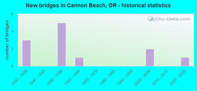
- New bridges - historical statistics
- 31930-1939
- 51950-1959
- 11960-1969
- 22000-2009
- 12020-2022


- Bridge Condition - Deck
- 12.5%Very good
- 37.5%Good
- 37.5%Satisfactory
- 12.5%Fair

- Bridge Condition - Superstructure
- 12.5%Very good
- 62.5%Good
- 25.0%Satisfactory

- Bridge Condition - Substructure
- 12.5%Very good
- 25.0%Good
- 50.0%Satisfactory
- 12.5%Poor

- Bridge Condition - Channel
- 75.0%Good
- 25.0%Satisfactory
Find on map >> Show street view
Structure Number: 1720 009F0287, Location: N.CANNON BEACH,5TH & 101 (Lat: 45.902150, Lng: -123.957931), Route carried "on" structure: City street , Year Built: 1964, Status: Open, Structure Length: 6.43m (21.10ft), Average Daily Traffic: 6,466 (year 2020), Truck Traffic: 10%, Average Future Daily Traffic: 10,250 (year 2025), Design Load: HS 20, Features Intersected: ECOLA CR. BR., Facility Carried by Structure: ALTERNATE HWY 101
Minimum Vertical Clearance: 30+ m (98+ ft), Kilometerpoint: 0.000, Lanes on structure: 2, Owner: City or Municipal Highway Agency, Approaching Roadway Width: 10.4m (34.1ft), Material/Design: Prestressed concrete, Design/Construction: Slab, Number Of Spans In Main Unit: 7, Length of Maximum Span: 9.1m (29.9ft), Curb or Sidewalk Widths: Left: 1.5m (4.9ft), Right: 1.5m (4.9ft), Curb-To-Curb Width: 9.8m (32.2ft), Out-to-Out Width: 13.4m (44.0ft)
Condition: Deck: Good, Superstructure: Good, Substructure: Good, Channel: Satisfactory, Operating Rating: 46.0 metric tons, Method Used To Determine Operating Rating: Load and Resistance Factor Rating (LRFR) rating reported by rating factor(RF) method using HL-93 loadings, Inventory Rating: 27.9 metric tons, Method Used To Determine Inventory Rating: Load and Resistance Factor Rating (LRFR) rating reported by rating factor(RF) method using HL-93 loadings, Structural Evaluation: Better than present minimum criteria, Deck Geometry: Meets minimum limits, Waterway Adequacy: Equal to present desirable criteria, Approach Roadway Alignment: Equal to present desirable criteria, Designated Inspection Frequency: Every 24 months, Underwater Inspection Frequency: Every 60 months, Inspection Date: April 2021, Underwater Inspection Date: August 2019, Deck Structure Type: Other, Wearing Surface/Protective System: Wearing Surface: Bituminous, Membrane: Preformed Fabric
Find on map >> Show street view
Structure Number: 1797 009 03557, Location: 001 MI N ARCH CAPE TUNNEL (Lat: 45.803269, Lng: -123.964769), Route carried "on" structure: US 101, Year Built: 1937, Status: Open, Structure Length: 5.06m (16.60ft), Average Daily Traffic: 4,523 (year 2020), Truck Traffic: 13%, Average Future Daily Traffic: 5,400 (year 2040), Design Load: H 15, Features Intersected: Arch Cape Creek
Minimum Vertical Clearance: 30+ m (98+ ft), Kilometerpoint: 57.244, Lanes on structure: 2, Lanes under structure: 1, Base Highway Network: Yes, Owner: State Highway Agency, Approaching Roadway Width: 7.9m (25.9ft), Material/Design: Wood or Timber, Design/Construction: Stringer/Multi-beam, Number Of Spans In Main Unit: 6, Length of Maximum Span: 8.8m (28.9ft), Curb or Sidewalk Widths: Left: 1.1m (3.6ft), Right: 1.1m (3.6ft), Curb-To-Curb Width: 7.9m (25.9ft), Out-to-Out Width: 10.8m (35.4ft)
Condition: Deck: Satisfactory, Superstructure: Good, Substructure: Satisfactory, Channel: Good, Operating Rating: 30.8 metric tons, Method Used To Determine Operating Rating: Load and Resistance Factor Rating (LRFR) rating reported by rating factor(RF) method using HL-93 loadings, Inventory Rating: 23.7 metric tons, Method Used To Determine Inventory Rating: Load and Resistance Factor Rating (LRFR) rating reported by rating factor(RF) method using HL-93 loadings, Structural Evaluation: Equal to present minimum criteria, Deck Geometry: High priority of corrective action, Underclear: Meets minimum limits, Waterway Adequacy: Equal to present desirable criteria, Approach Roadway Alignment: Equal to present desirable criteria, Length Of Structure Improvement: 5.10m (16.73ft), Designated Inspection Frequency: Every 24 months, Inspection Date: October 2021, Bridge Improvement Cost: $532,000, Roadway Improvement Cost: $53,000, Total Project Cost: $850,000, Deck Structure Type: Concrete Cast-file-Place, Wearing Surface/Protective System: Wearing Surface: Bituminous, Membrane: Preformed Fabric
Find on map >> Show street view
Structure Number: 1878 009 03405, Location: 015 MI N ARCH CAPE TUNNEL (Lat: 45.824900, Lng: -123.961000), Route carried "on" structure: US 101, Year Built: 1933, Status: Open, Structure Length: 4.05m (13.29ft), Average Daily Traffic: 4,523 (year 2020), Truck Traffic: 13%, Average Future Daily Traffic: 5,400 (year 2040), Design Load: H 15, Features Intersected: Austins Point
Minimum Vertical Clearance: 30+ m (98+ ft), Kilometerpoint: 54.798, Lanes on structure: 2, Base Highway Network: Yes, Owner: State Highway Agency, Approaching Roadway Width: 9.0m (29.5ft), Material/Design: Wood or Timber, Design/Construction: Stringer/Multi-beam, Number Of Spans In Main Unit: 6, Length of Maximum Span: 7.2m (23.6ft), Curb or Sidewalk Widths: Left: 0.0m, Right: 1.1m (3.6ft), Curb-To-Curb Width: 9.0m (29.5ft), Out-to-Out Width: 9.0m (29.5ft)
Condition: Deck: Satisfactory, Superstructure: Good, Substructure: Satisfactory, Operating Rating: 34.3 metric tons, Method Used To Determine Operating Rating: Load and Resistance Factor Rating (LRFR) rating reported by rating factor(RF) method using HL-93 loadings, Inventory Rating: 26.6 metric tons, Method Used To Determine Inventory Rating: Load and Resistance Factor Rating (LRFR) rating reported by rating factor(RF) method using HL-93 loadings, Structural Evaluation: Equal to present minimum criteria, Deck Geometry: Meets minimum limits, Approach Roadway Alignment: Equal to present desirable criteria, Designated Inspection Frequency: Every 24 months, Inspection Date: October 2021, Deck Structure Type: Concrete Cast-file-Place, Wearing Surface/Protective System: Wearing Surface: Bituminous
Find on map >> Show street view
Structure Number: 6713 009 0287, Location: 037 MI S CANNON BEACH JCT (Lat: 45.899389, Lng: -123.953889), Route carried "on" structure: US 101, Year Built: 1952, Status: Open, Structure Length: 4.75m (15.58ft), Average Daily Traffic: 6,003 (year 2020), Truck Traffic: 13%, Average Future Daily Traffic: 6,900 (year 2040), Design Load: HS 20, Features Intersected: Ecola Creek
Minimum Vertical Clearance: 30+ m (98+ ft), Kilometerpoint: 46.188, Lanes on structure: 2, Base Highway Network: Yes, Owner: State Highway Agency, Approaching Roadway Width: 11.6m (38.1ft), Material/Design: Concrete continuous, Design/Construction: Slab, Number Of Spans In Main Unit: 8, Length of Maximum Span: 6.1m (20.0ft), Curb-To-Curb Width: 11.6m (38.1ft), Out-to-Out Width: 13.0m (42.7ft)
Condition: Deck: Satisfactory, Superstructure: Satisfactory, Substructure: Poor, Channel: Good, Operating Rating: 32.7 metric tons, Method Used To Determine Operating Rating: Load Factor (LF), Inventory Rating: 20.0 metric tons, Method Used To Determine Inventory Rating: Load Factor (LF), Structural Evaluation: Meets minimum limits, Deck Geometry: Somewhat better than minimum adequacy, Waterway Adequacy: Equal to present desirable criteria, Approach Roadway Alignment: Equal to present desirable criteria, Length Of Structure Improvement: 5.20m (17.06ft), Designated Inspection Frequency: Every 24 months, Underwater Inspection Frequency: Every 36 months, Inspection Date: October 2021, Underwater Inspection Date: November 2021, Bridge Improvement Cost: $549,000, Roadway Improvement Cost: $55,000, Total Project Cost: $879,000, Deck Structure Type: Concrete Cast-file-Place, Wearing Surface/Protective System: Wearing Surface: Bituminous
Find on map >> Show street view
Structure Number: 7226 009 02953, Location: 0.43M S CANNON BEACH JCT. (Lat: 45.887661, Lng: -123.958111), Route carried "on" structure: US 101, Year Built: 1952, Status: Open, Structure Length: 3.05m (10.01ft), Average Daily Traffic: 6,866 (year 2020), Truck Traffic: 13%, Average Future Daily Traffic: 7,400 (year 2040), Design Load: HS 20, Features Intersected: Sunset Blvd.
Minimum Vertical Clearance: 30+ m (98+ ft), Kilometerpoint: 47.524, Lanes on structure: 2, Lanes under structure: 2, Base Highway Network: Yes, Owner: State Highway Agency, Approaching Roadway Width: 11.6m (38.1ft), Material/Design: Concrete continuous, Design/Construction: Tee Beam, Number Of Spans In Main Unit: 3, Length of Maximum Span: 12.2m (40.0ft), Curb-To-Curb Width: 11.6m (38.1ft), Out-to-Out Width: 12.9m (42.3ft)
Condition: Deck: Fair, Superstructure: Good, Substructure: Satisfactory, Operating Rating: 36.3 metric tons, Method Used To Determine Operating Rating: Load Factor (LF), Inventory Rating: 21.8 metric tons, Method Used To Determine Inventory Rating: Load Factor (LF), Structural Evaluation: Somewhat better than minimum adequacy, Deck Geometry: Somewhat better than minimum adequacy, Underclear: Meets minimum limits, Approach Roadway Alignment: Equal to present desirable criteria, Designated Inspection Frequency: Every 24 months, Inspection Date: October 2021, Deck Structure Type: Concrete Cast-file-Place, Wearing Surface/Protective System: Wearing Surface: Bituminous
Find on map >> Show street view
Structure Number: 7405 009 03062, Location: 050 MI N ARCH CAPE TUNNEL (Lat: 45.872239, Lng: -123.958139), Route carried "on" structure: US 101, Year Built: 1952, Status: Open, Structure Length: 3.05m (10.01ft), Average Daily Traffic: 4,592 (year 2020), Truck Traffic: 13%, Average Future Daily Traffic: 6,300 (year 2040), Design Load: HS 20, Features Intersected: Warren Street
Minimum Vertical Clearance: 30+ m (98+ ft), Kilometerpoint: 49.278, Lanes on structure: 2, Lanes under structure: 2, Base Highway Network: Yes, Owner: State Highway Agency, Approaching Roadway Width: 11.6m (38.1ft), Material/Design: Concrete continuous, Design/Construction: Tee Beam, Number Of Spans In Main Unit: 3, Length of Maximum Span: 12.2m (40.0ft), Curb-To-Curb Width: 11.6m (38.1ft), Out-to-Out Width: 12.9m (42.3ft)
Condition: Deck: Good, Superstructure: Satisfactory, Substructure: Satisfactory, Operating Rating: 52.6 metric tons, Method Used To Determine Operating Rating: Load Factor (LF), Inventory Rating: 31.8 metric tons, Method Used To Determine Inventory Rating: Load Factor (LF), Structural Evaluation: Equal to present minimum criteria, Deck Geometry: Somewhat better than minimum adequacy, Underclear: Meets minimum limits, Approach Roadway Alignment: Equal to present desirable criteria, Designated Inspection Frequency: Every 24 months, Inspection Date: October 2021, Deck Structure Type: Concrete Cast-file-Place, Wearing Surface/Protective System: Wearing Surface: Bituminous
Find on map >> Show street view
Structure Number: 18658 009 02837, Location: N CANNON BEACH INTCH (Lat: 45.904061, Lng: -123.953611), Route carried "on" structure: US 101, Year Built: 2003, Status: Open, Structure Length: 3.60m (11.81ft), Average Daily Traffic: 6,003 (year 2020), Truck Traffic: 13%, Average Future Daily Traffic: 6,900 (year 2040), Design Load: HL 93, Features Intersected: US 101 (Hwy 9) Conn.
Minimum Vertical Clearance: 30+ m (98+ ft), Kilometerpoint: 45.657, Lanes on structure: 2, Lanes under structure: 1, Base Highway Network: Yes, Owner: State Highway Agency, Approaching Roadway Width: 13.2m (43.3ft), Skew: 3 degrees, Material/Design: Prestressed concrete, Design/Construction: Box Beam or Girders - Multiple, Number Of Spans In Main Unit: 1, Length of Maximum Span: 36.0m (118.1ft), Curb-To-Curb Width: 13.2m (43.3ft), Out-to-Out Width: 14.0m (45.9ft)
Condition: Deck: Good, Superstructure: Good, Substructure: Good, Operating Rating: 72.3 metric tons, Method Used To Determine Operating Rating: Load and Resistance Factor Rating (LRFR) rating reported by rating factor(RF) method using HL-93 loadings, Inventory Rating: 55.7 metric tons, Method Used To Determine Inventory Rating: Load and Resistance Factor Rating (LRFR) rating reported by rating factor(RF) method using HL-93 loadings, Structural Evaluation: Better than present minimum criteria, Deck Geometry: Somewhat better than minimum adequacy, Underclear: Meets minimum limits, Approach Roadway Alignment: Equal to present desirable criteria, Designated Inspection Frequency: Every 24 months, Inspection Date: October 2021, Deck Structure Type: Concrete Cast-file-Place, Wearing Surface/Protective System: Wearing Surface: Latex Concrete
Find on map >> Show street view
Structure Number: 23885, Location: Ecola St. Park (Lat: 45.930489, Lng: -123.973547), Route carried "on" structure: ServiceState lands road , Year Built: 2020, Status: Open, Structure Length: 1.31m (4.30ft), Average Daily Traffic: 10 (year 2010), Average Future Daily Traffic: 15 (year 2030), Design Load: HL 93, Features Intersected: Canyon Creek, Facility Carried by Structure: Ecola Park Road
Minimum Vertical Clearance: 30+ m (98+ ft), Kilometerpoint: 0.000, Lanes on structure: 2, Owner: State Park, Forest, or Reservation Agency, Approaching Roadway Width: 6.1m (20.0ft), Skew: 3 degrees, Material/Design: Prestressed concrete, Design/Construction: Slab, Number Of Spans In Main Unit: 1, Length of Maximum Span: 13.1m (43.0ft), Curb-To-Curb Width: 6.1m (20.0ft), Out-to-Out Width: 6.6m (21.7ft)
Condition: Deck: Very good, Superstructure: Very good, Substructure: Very good, Channel: Good, Operating Rating: 75.2 metric tons, Method Used To Determine Operating Rating: Load and Resistance Factor Rating (LRFR) rating reported by rating factor(RF) method using HL-93 loadings, Inventory Rating: 58.0 metric tons, Method Used To Determine Inventory Rating: Load and Resistance Factor Rating (LRFR) rating reported by rating factor(RF) method using HL-93 loadings, Structural Evaluation: Equal to present desirable criteria, Deck Geometry: Somewhat better than minimum adequacy, Waterway Adequacy: Equal to present desirable criteria, Approach Roadway Alignment: Equal to present desirable criteria, Designated Inspection Frequency: Every 24 months, Inspection Date: October 2021, Wearing Surface/Protective System: Wearing Surface: Bituminous
Find on map >> Show street view
Structure Number: 1797 009 03557, Location: 001 MI N ARCH CAPE TUNNEL (Lat: 45.803269, Lng: -123.964769), Route carried "under" structure: ServiceCity street , Year Built: 1937, Structure Length: 0. m, Average Daily Traffic: 50 (year 2010), Features Intersected: Arch Cape Creek, Facility Carried by Structure: US101 (Hwy 9)
Minimum Vertical Clearance: 5.79m (19.00ft), Kilometerpoint: 57.244, Lanes on structure: 2, Lanes under structure: 1, Material/Design: Wood or Timber, Design/Construction: Stringer/Multi-beam, Length of Maximum Span: 8.8m (28.9ft)
Find on map >> Show street view
Structure Number: 7226 009 02953, Location: 0.43M S CANNON BEACH JCT. (Lat: 45.887661, Lng: -123.958111), Route carried "under" structure: County highway , Year Built: 1952, Structure Length: 0. m, Average Daily Traffic: 6,200 (year 2010), Truck Traffic: 7%, Features Intersected: Sunset Blvd., Facility Carried by Structure: US101 (Hwy 9)
Minimum Vertical Clearance: 4.62m (15.16ft), Kilometerpoint: 47.524, Lanes on structure: 2, Lanes under structure: 2, Material/Design: Concrete continuous, Design/Construction: Tee Beam, Length of Maximum Span: 12.2m (40.0ft)
Find on map >> Show street view
Structure Number: 7405 009 03062, Location: 050 MI N ARCH CAPE TUNNEL (Lat: 45.872239, Lng: -123.958139), Route carried "under" structure: ServiceCity street , Year Built: 1952, Structure Length: 0. m, Average Daily Traffic: 5,400 (year 2010), Truck Traffic: 7%, Features Intersected: Warren Street, Facility Carried by Structure: US101 (Hwy 9)
Minimum Vertical Clearance: 4.90m (16.08ft), Kilometerpoint: 49.278, Lanes on structure: 2, Lanes under structure: 2, Material/Design: Concrete continuous, Design/Construction: Tee Beam, Length of Maximum Span: 12.2m (40.0ft)
Find on map >> Show street view
Structure Number: 18658 009 02837, Location: N CANNON BEACH INTCH (Lat: 45.904061, Lng: -123.953611), Route carried "under" structure: Ramp US 101, Year Built: 2003, Structure Length: 0. m, Average Daily Traffic: 9,200 (year 2010), Truck Traffic: 7%, Features Intersected: US 101 (Hwy 9) Conn.
Minimum Vertical Clearance: 5.25m (17.22ft), Kilometerpoint: 45.657, Lanes on structure: 2, Lanes under structure: 1, Material/Design: Prestressed concrete, Design/Construction: Box Beam or Girders - Multiple, Length of Maximum Span: 36.0m (118.1ft)