Bridge Statistics for Camp Verde, Arizona (AZ)
Condition, Traffic, Stress, Structural Evaluation, Project Costs
- National Bridge Inventory (NBI) Statistics
- 40Number of bridges
- 577ft / 176mTotal length
- $6,000Total costs
- 387,347Total average daily traffic
- 47,118Total average daily truck traffic
- National Bridge Inventory (NBI) Registered Bridges for Camp Verde
- No street view available for this location
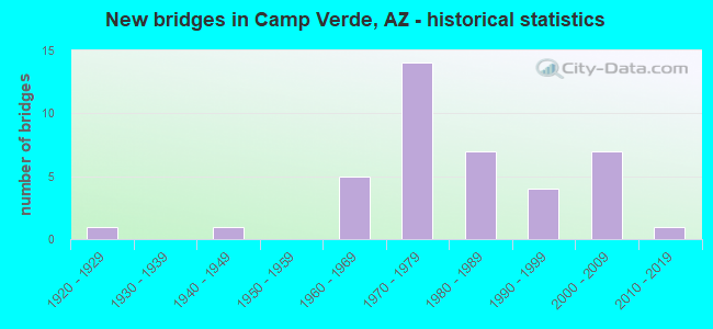
- New bridges - historical statistics
- 11920-1929
- 11940-1949
- 51960-1969
- 141970-1979
- 71980-1989
- 41990-1999
- 72000-2009
- 12010-2019
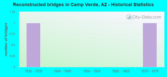
- Reconstructed bridges - Historical Statistics
- 11930-1939
- 01940-1949
- 01950-1959
- 01960-1969
- 11970-1979
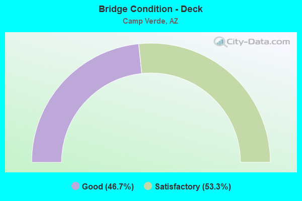
- Bridge Condition - Deck
- 46.7%Good
- 53.3%Satisfactory
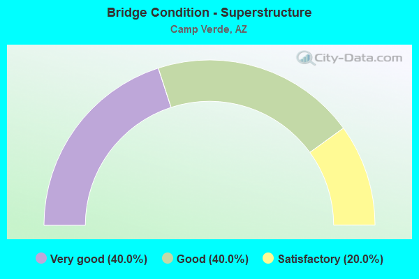
- Bridge Condition - Superstructure
- 40.0%Very good
- 40.0%Good
- 20.0%Satisfactory
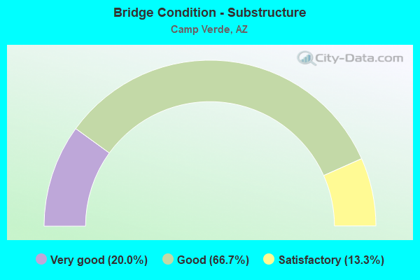
- Bridge Condition - Substructure
- 20.0%Very good
- 66.7%Good
- 13.3%Satisfactory
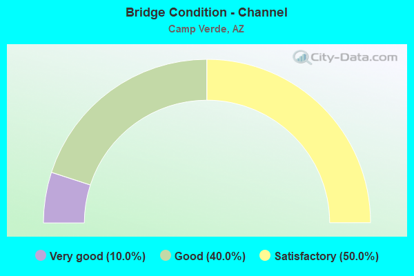
- Bridge Condition - Channel
- 10.0%Very good
- 40.0%Good
- 50.0%Satisfactory
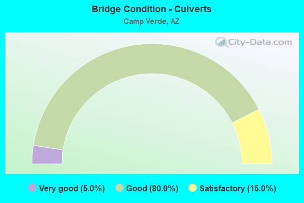
- Bridge Condition - Culverts
- 5.0%Very good
- 80.0%Good
- 15.0%Satisfactory
Find on map >> Show street view
Structure Number: H68601B0236, Location: 0.9 KM NW HWY 89A (Lat: 34.768944, Lng: -112.069361), Route carried "on" structure: Federal lands road 105, Year Built: 1980, Status: Open, Structure Length: 0.71m (2.33ft), Average Daily Traffic: 50 (year 2021), Truck Traffic: 1%, Average Future Daily Traffic: 59 (year 2039), Design Load: HS 20, Features Intersected: BITTER CREEK
Minimum Vertical Clearance: 99.90m (327.76ft), Kilometerpoint: 0.050, Lanes on structure: 2, Owner: Bureau of Indian Affairs, Approaching Roadway Width: 8.9m (29.2ft), Skew: 2 degrees, Material/Design: Concrete, Design/Construction: Culvert, Number Of Spans In Main Unit: 2, Length of Maximum Span: 3.4m (11.2ft), Curb or Sidewalk Widths: Left: 0.5m (1.6ft), Right: 0.5m (1.6ft), Curb-To-Curb Width: 9.7m (31.8ft), Out-to-Out Width: 10.7m (35.1ft)
Condition: Channel: Satisfactory, Culverts: Satisfactory, Operating Rating: 44.2 metric tons, Method Used To Determine Operating Rating: Load Factor (LF), Inventory Rating: 32.4 metric tons, Method Used To Determine Inventory Rating: Load Factor (LF), Structural Evaluation: Equal to present minimum criteria, Deck Geometry: Better than present minimum criteria, Waterway Adequacy: Superior to present desirable criteria, Approach Roadway Alignment: Equal to present desirable criteria, Designated Inspection Frequency: Every 24 months, Inspection Date: December 2021
Find on map >> Show street view
Structure Number: H68601B0237, Location: 100 M SE OF TRIBAL HDQRS (Lat: 34.626500, Lng: -111.891833), Route carried "on" structure: Federal lands road 102, Year Built: 2008, Status: Open, Structure Length: 1.01m (3.31ft), Average Daily Traffic: 100 (year 2021), Truck Traffic: 10%, Average Future Daily Traffic: 120 (year 2039), Design Load: HS 20, Features Intersected: WASH
Minimum Vertical Clearance: 99.90m (327.76ft), Kilometerpoint: 0.740, Lanes on structure: 2, Owner: Bureau of Indian Affairs, Approaching Roadway Width: 7.8m (25.6ft), Skew: 1 degrees, Material/Design: Concrete, Design/Construction: Culvert, Number Of Spans In Main Unit: 3, Length of Maximum Span: 3.2m (10.5ft), Curb-To-Curb Width: 7.9m (25.9ft), Out-to-Out Width: 7.9m (25.9ft)
Condition: Channel: Very good, Culverts: Good, Operating Rating: 44.2 metric tons, Method Used To Determine Operating Rating: Allowable Stress (AS), Inventory Rating: 32.4 metric tons, Method Used To Determine Inventory Rating: Allowable Stress (AS), Structural Evaluation: Better than present minimum criteria, Deck Geometry: Equal to present minimum criteria, Waterway Adequacy: Better than present minimum criteria, Approach Roadway Alignment: Equal to present desirable criteria, Designated Inspection Frequency: Every 24 months, Inspection Date: December 2021
Find on map >> Show street view
Structure Number: H68601B0238, Location: SW OF TRIBAL ADMIN HDQRS (Lat: 34.625944, Lng: -111.893139), Route carried "on" structure: Federal lands road 102, Year Built: 2008, Status: Open, Structure Length: 1.17m (3.84ft), Average Daily Traffic: 40 (year 2021), Truck Traffic: 1%, Average Future Daily Traffic: 45 (year 2039), Design Load: HS 20, Features Intersected: WASH
Minimum Vertical Clearance: 30+ m (98+ ft), Kilometerpoint: 0.130, Lanes on structure: 2, Owner: Bureau of Indian Affairs, Approaching Roadway Width: 9.3m (30.5ft), Skew: 3 degrees, Material/Design: Concrete, Design/Construction: Culvert, Number Of Spans In Main Unit: 3, Length of Maximum Span: 3.8m (12.5ft), Curb-To-Curb Width: 9.3m (30.5ft), Out-to-Out Width: 9.3m (30.5ft)
Condition: Channel: Very good, Culverts: Good, Operating Rating: 44.2 metric tons, Method Used To Determine Operating Rating: Allowable Stress (AS), Inventory Rating: 32.4 metric tons, Method Used To Determine Inventory Rating: Allowable Stress (AS), Structural Evaluation: Better than present minimum criteria, Deck Geometry: Better than present minimum criteria, Waterway Adequacy: Better than present minimum criteria, Approach Roadway Alignment: Equal to present desirable criteria, Designated Inspection Frequency: Every 24 months, Inspection Date: December 2021
Find on map >> Show street view
Structure Number: H68601B0239, Location: 0.8 KM E OF HWY 260 (Lat: 34.610222, Lng: -111.903472), Route carried "on" structure: Federal lands road 111, Year Built: 1990, Status: Open, Structure Length: 1.69m (5.54ft), Average Daily Traffic: 20 (year 2021), Truck Traffic: 1%, Average Future Daily Traffic: 25 (year 2039), Design Load: HS 20, Features Intersected: WASH
Minimum Vertical Clearance: 99.90m (327.76ft), Kilometerpoint: 0.600, Lanes on structure: 2, Owner: Bureau of Indian Affairs, Approaching Roadway Width: 9.9m (32.5ft), Skew: 1 degrees, Material/Design: Concrete, Design/Construction: Culvert, Number Of Spans In Main Unit: 5, Length of Maximum Span: 3.1m (10.2ft), Curb-To-Curb Width: 9.9m (32.5ft), Out-to-Out Width: 9.9m (32.5ft)
Condition: Channel: Satisfactory, Culverts: Good, Operating Rating: 44.2 metric tons, Method Used To Determine Operating Rating: Load Factor (LF), Inventory Rating: 32.4 metric tons, Method Used To Determine Inventory Rating: Load Factor (LF), Structural Evaluation: Better than present minimum criteria, Deck Geometry: Superior to present desirable criteria, Waterway Adequacy: Equal to present desirable criteria, Approach Roadway Alignment: Equal to present desirable criteria, Designated Inspection Frequency: Every 24 months, Inspection Date: December 2021
Find on map >> Show street view
Structure Number: 236, Location: 7.0 mi E Jct SR 92 (Lat: 31.416081, Lng: -109.793531), Route carried "on" structure: State highway 80, Year Built: 1920, Year Reconstructed: 1936, Status: Open, Structure Length: 1.46m (4.79ft), Average Daily Traffic: 4,474 (year 2017), Truck Traffic: 10%, Average Future Daily Traffic: 4,484 (year 2038), Design Load: HS 20, Features Intersected: Wash
Minimum Vertical Clearance: 30+ m (98+ ft), Kilometerpoint: 564.429, Lanes on structure: 2, Owner: State Highway Agency, Approaching Roadway Width: 11.0m (36.1ft), Material/Design: Concrete continuous, Design/Construction: Slab, Number Of Spans In Main Unit: 3, Length of Maximum Span: 4.9m (16.1ft), Curb-To-Curb Width: 11.0m (36.1ft), Out-to-Out Width: 12.9m (42.3ft)
Condition: Deck: Satisfactory, Superstructure: Satisfactory, Substructure: Satisfactory, Channel: Good, Operating Rating: 53.5 metric tons, Method Used To Determine Operating Rating: Load Factor (LF), Inventory Rating: 32.7 metric tons, Method Used To Determine Inventory Rating: Load Factor (LF), Structural Evaluation: Equal to present minimum criteria, Deck Geometry: Somewhat better than minimum adequacy, Waterway Adequacy: Equal to present desirable criteria, Approach Roadway Alignment: Equal to present desirable criteria, Designated Inspection Frequency: Every 24 months, Inspection Date: May 2020, Deck Structure Type: Concrete Cast-file-Place, Wearing Surface/Protective System: Wearing Surface: Bituminous
Find on map >> Show street view
Structure Number: 505, Location: 0.6 mi N Jct SR 260 (Lat: 34.586200, Lng: -111.879900), Route carried "on" structure: Interstate 17, Year Built: 1961, Status: Open, Structure Length: 16.00m (52.49ft), Average Daily Traffic: 16,022 (year 2019), Truck Traffic: 13%, Average Future Daily Traffic: 16,032 (year 2039), Design Load: HS 20, Features Intersected: Verde River
Minimum Vertical Clearance: 30+ m (98+ ft), Kilometerpoint: 463.555, Lanes on structure: 2, Owner: State Highway Agency, Approaching Roadway Width: 12.2m (40.0ft), Skew: 2 degrees, Material/Design: Steel continuous, Design/Construction: Stringer/Multi-beam, Number Of Spans In Main Unit: 7, Length of Maximum Span: 26.2m (86.0ft), Curb-To-Curb Width: 12.8m (42.0ft), Out-to-Out Width: 13.8m (45.3ft)
Condition: Deck: Good, Superstructure: Satisfactory, Substructure: Satisfactory, Channel: Satisfactory, Operating Rating: 55.3 metric tons, Method Used To Determine Operating Rating: Load Factor (LF), Inventory Rating: 32.7 metric tons, Method Used To Determine Inventory Rating: Load Factor (LF), Structural Evaluation: Equal to present minimum criteria, Deck Geometry: Equal to present desirable criteria, Waterway Adequacy: Equal to present desirable criteria, Approach Roadway Alignment: Equal to present desirable criteria, Designated Inspection Frequency: Every 24 months, Inspection Date: September 2020, Deck Structure Type: Concrete Cast-file-Place, Wearing Surface/Protective System: Wearing Surface: Monolithic Concrete, Deck Protection: Epoxy Coated Reinforcing
Find on map >> Show street view
Structure Number: 1662, Location: 1.8 mi S Jct SR 260 (Lat: 34.559800, Lng: -111.906600), Route carried "on" structure: Interstate 17, Year Built: 1975, Status: Open, Structure Length: 4.42m (14.50ft), Average Daily Traffic: 16,823 (year 2018), Truck Traffic: 14%, Average Future Daily Traffic: 16,833 (year 2040), Design Load: HS 20, Features Intersected: General Crook Trail
Minimum Vertical Clearance: 30+ m (98+ ft), Kilometerpoint: 459.419, Lanes on structure: 3, Lanes under structure: 2, Owner: State Highway Agency, Approaching Roadway Width: 11.6m (38.1ft), Material/Design: Concrete continuous, Design/Construction: Box Beam or Girders - Single/Spread, Number Of Spans In Main Unit: 3, Length of Maximum Span: 21.9m (71.9ft), Curb-To-Curb Width: 18.9m (62.0ft), Out-to-Out Width: 19.7m (64.6ft)
Condition: Deck: Satisfactory, Superstructure: Good, Substructure: Good, Operating Rating: 65.3 metric tons, Method Used To Determine Operating Rating: Load Factor (LF), Inventory Rating: 39.0 metric tons, Method Used To Determine Inventory Rating: Load Factor (LF), Structural Evaluation: Better than present minimum criteria, Deck Geometry: Superior to present desirable criteria, Underclear: Superior to present desirable criteria, Approach Roadway Alignment: Equal to present desirable criteria, Designated Inspection Frequency: Every 24 months, Inspection Date: July 2020, Deck Structure Type: Concrete Cast-file-Place, Wearing Surface/Protective System: Wearing Surface: Bituminous
Find on map >> Show street view
Structure Number: 1663, Location: 1.8 mi S Jct SR 260 (Lat: 34.559000, Lng: -111.904500), Route carried "on" structure: Interstate 17, Year Built: 1975, Status: Open, Structure Length: 4.42m (14.50ft), Average Daily Traffic: 17,581 (year 2018), Truck Traffic: 14%, Average Future Daily Traffic: 17,591 (year 2040), Design Load: HS 20, Features Intersected: General Crook Trail
Minimum Vertical Clearance: 30+ m (98+ ft), Kilometerpoint: 459.419, Lanes on structure: 2, Lanes under structure: 2, Owner: State Highway Agency, Approaching Roadway Width: 11.6m (38.1ft), Skew: 1 degrees, Material/Design: Concrete continuous, Design/Construction: Box Beam or Girders - Single/Spread, Number Of Spans In Main Unit: 3, Length of Maximum Span: 21.9m (71.9ft), Curb-To-Curb Width: 12.8m (42.0ft), Out-to-Out Width: 13.6m (44.6ft)
Condition: Deck: Satisfactory, Superstructure: Good, Substructure: Good, Operating Rating: 65.3 metric tons, Method Used To Determine Operating Rating: Load Factor (LF), Inventory Rating: 39.0 metric tons, Method Used To Determine Inventory Rating: Load Factor (LF), Structural Evaluation: Better than present minimum criteria, Deck Geometry: Equal to present desirable criteria, Underclear: Superior to present desirable criteria, Approach Roadway Alignment: Equal to present desirable criteria, Designated Inspection Frequency: Every 24 months, Inspection Date: July 2020, Deck Structure Type: Concrete Cast-file-Place, Wearing Surface/Protective System: Wearing Surface: Bituminous
Find on map >> Show street view
Structure Number: 1731, Location: 0.6 mi N Jct SR 260 (Lat: 34.586000, Lng: -111.879600), Route carried "on" structure: Interstate 17, Year Built: 1979, Status: Open, Structure Length: 15.97m (52.40ft), Average Daily Traffic: 16,022 (year 2019), Truck Traffic: 13%, Average Future Daily Traffic: 16,032 (year 2039), Design Load: HS 20, Features Intersected: Verde River
Minimum Vertical Clearance: 30+ m (98+ ft), Kilometerpoint: 463.475, Lanes on structure: 2, Owner: State Highway Agency, Approaching Roadway Width: 11.6m (38.1ft), Skew: 2 degrees, Material/Design: Steel continuous, Design/Construction: Stringer/Multi-beam, Number Of Spans In Main Unit: 7, Length of Maximum Span: 26.2m (86.0ft), Curb-To-Curb Width: 12.8m (42.0ft), Out-to-Out Width: 13.6m (44.6ft)
Condition: Deck: Satisfactory, Superstructure: Satisfactory, Substructure: Good, Channel: Satisfactory, Operating Rating: 57.2 metric tons, Method Used To Determine Operating Rating: Load Factor (LF), Inventory Rating: 34.5 metric tons, Method Used To Determine Inventory Rating: Load Factor (LF), Structural Evaluation: Equal to present minimum criteria, Deck Geometry: Equal to present desirable criteria, Waterway Adequacy: Equal to present desirable criteria, Approach Roadway Alignment: Equal to present desirable criteria, Designated Inspection Frequency: Every 24 months, Inspection Date: September 2020, Deck Structure Type: Concrete Cast-file-Place, Wearing Surface/Protective System: Wearing Surface: Epoxy Overlay
Find on map >> Show street view
Structure Number: 1732, Location: 1.6 mi N Jct SR 260 (Lat: 34.599600, Lng: -111.873100), Route carried "on" structure: County highway , Year Built: 1978, Status: Open, Structure Length: 8.32m (27.30ft), Average Daily Traffic: 900 (year 2019), Truck Traffic: 1%, Average Future Daily Traffic: 910 (year 2039), Design Load: HS 20, Features Intersected: I-17, Facility Carried by Structure: Arena Del Loma
Minimum Vertical Clearance: 30+ m (98+ ft), Kilometerpoint: 0.000, Lanes on structure: 2, Lanes under structure: 4, Owner: State Highway Agency, Approaching Roadway Width: 10.4m (34.1ft), Material/Design: Steel continuous, Design/Construction: Stringer/Multi-beam, Number Of Spans In Main Unit: 2, Length of Maximum Span: 41.1m (134.8ft), Curb-To-Curb Width: 11.6m (38.1ft), Out-to-Out Width: 12.4m (40.7ft)
Condition: Deck: Satisfactory, Superstructure: Good, Substructure: Good, Operating Rating: 74.4 metric tons, Method Used To Determine Operating Rating: Load Factor (LF), Inventory Rating: 44.5 metric tons, Method Used To Determine Inventory Rating: Load Factor (LF), Structural Evaluation: Better than present minimum criteria, Deck Geometry: Better than present minimum criteria, Underclear: Better than present minimum criteria, Approach Roadway Alignment: Equal to present minimum criteria, Designated Inspection Frequency: Every 24 months, Inspection Date: July 2021, Deck Structure Type: Concrete Cast-file-Place, Wearing Surface/Protective System: Wearing Surface: Monolithic Concrete
Find on map >> Show street view
Structure Number: 1733, Location: 2.7 mi N Jct SR 260 (Lat: 34.611500, Lng: -111.861900), Route carried "on" structure: County highway , Year Built: 1978, Status: Open, Structure Length: 8.32m (27.30ft), Average Daily Traffic: 2,875 (year 2019), Truck Traffic: 7%, Average Future Daily Traffic: 2,885 (year 2039), Design Load: HS 20, Features Intersected: I-17, Facility Carried by Structure: Middle Verde Road
Minimum Vertical Clearance: 30+ m (98+ ft), Kilometerpoint: 0.000, Lanes on structure: 2, Lanes under structure: 4, Owner: State Highway Agency, Approaching Roadway Width: 12.2m (40.0ft), Material/Design: Steel continuous, Design/Construction: Stringer/Multi-beam, Number Of Spans In Main Unit: 2, Length of Maximum Span: 41.1m (134.8ft), Curb-To-Curb Width: 13.4m (44.0ft), Out-to-Out Width: 14.2m (46.6ft)
Condition: Deck: Satisfactory, Superstructure: Good, Substructure: Good, Operating Rating: 74.4 metric tons, Method Used To Determine Operating Rating: Load Factor (LF), Inventory Rating: 44.5 metric tons, Method Used To Determine Inventory Rating: Load Factor (LF), Structural Evaluation: Better than present minimum criteria, Deck Geometry: Better than present minimum criteria, Underclear: Somewhat better than minimum adequacy, Approach Roadway Alignment: Equal to present minimum criteria, Designated Inspection Frequency: Every 24 months, Inspection Date: August 2021, Deck Structure Type: Concrete Cast-file-Place, Wearing Surface/Protective System: Wearing Surface: Monolithic Concrete
Find on map >> Show street view
Structure Number: 2299, Location: 3.5 mi E Jct I-17 (Lat: 34.551700, Lng: -111.852200), Route carried "on" structure: State highway 260, Year Built: 1982, Status: Open, Structure Length: 19.81m (64.99ft), Average Daily Traffic: 4,397 (year 2018), Truck Traffic: 13%, Average Future Daily Traffic: 4,407 (year 2040), Design Load: HS 20, Features Intersected: Verde River
Minimum Vertical Clearance: 30+ m (98+ ft), Kilometerpoint: 356.615, Lanes on structure: 2, Owner: State Highway Agency, Approaching Roadway Width: 10.4m (34.1ft), Skew: 20 degrees, Material/Design: Prestressed concrete continuous, Design/Construction: Box Beam or Girders - Single/Spread, Number Of Spans In Main Unit: 4, Length of Maximum Span: 55.2m (181.1ft), Curb or Sidewalk Widths: Left: 0.0m, Right: 3.7m (12.1ft), Curb-To-Curb Width: 10.4m (34.1ft), Out-to-Out Width: 15.3m (50.2ft)
Condition: Deck: Good, Superstructure: Very good, Substructure: Good, Channel: Satisfactory, Operating Rating: 89.8 metric tons, Method Used To Determine Operating Rating: Load Factor (LF), Inventory Rating: 34.5 metric tons, Method Used To Determine Inventory Rating: Load Factor (LF), Structural Evaluation: Better than present minimum criteria, Deck Geometry: Somewhat better than minimum adequacy, Waterway Adequacy: Equal to present desirable criteria, Approach Roadway Alignment: Equal to present desirable criteria, Designated Inspection Frequency: Every 24 months, Inspection Date: July 2020, Deck Structure Type: Concrete Cast-file-Place, Wearing Surface/Protective System: Wearing Surface: Monolithic Concrete
Find on map >> Show street view
Structure Number: 23, Location: 6.7 mi E Jct I-17 (Lat: 34.532300, Lng: -111.811000), Route carried "on" structure: State highway 260, Year Built: 1981, Status: Open, Structure Length: 3.26m (10.70ft), Average Daily Traffic: 4,812 (year 2018), Truck Traffic: 12%, Average Future Daily Traffic: 4,822 (year 2040), Design Load: HS 20, Features Intersected: Wickiup Wash
Minimum Vertical Clearance: 30+ m (98+ ft), Kilometerpoint: 361.185, Lanes on structure: 2, Owner: State Highway Agency, Approaching Roadway Width: 10.4m (34.1ft), Skew: 1 degrees, Material/Design: Prestressed concrete, Design/Construction: Stringer/Multi-beam, Number Of Spans In Main Unit: 1, Length of Maximum Span: 31.7m (104.0ft), Curb-To-Curb Width: 10.4m (34.1ft), Out-to-Out Width: 11.2m (36.7ft)
Condition: Deck: Good, Superstructure: Very good, Substructure: Good, Channel: Satisfactory, Operating Rating: 89.8 metric tons, Method Used To Determine Operating Rating: Load Factor (LF), Inventory Rating: 36.3 metric tons, Method Used To Determine Inventory Rating: Load Factor (LF), Structural Evaluation: Better than present minimum criteria, Deck Geometry: Somewhat better than minimum adequacy, Waterway Adequacy: Equal to present desirable criteria, Approach Roadway Alignment: Equal to present desirable criteria, Length Of Structure Improvement: 4.08m (13.39ft), Designated Inspection Frequency: Every 24 months, Inspection Date: July 2020, Total Project Cost: $1,000 ( Estimate for 2020), Deck Structure Type: Concrete Cast-file-Place, Wearing Surface/Protective System: Wearing Surface: Monolithic Concrete
Find on map >> Show street view
Structure Number: 2301, Location: 9.5 mi E Jct I-17 (Lat: 34.519300, Lng: -111.775000), Route carried "on" structure: State highway 260, Year Built: 1981, Status: Open, Structure Length: 9.14m (29.99ft), Average Daily Traffic: 2,464 (year 2018), Truck Traffic: 9%, Average Future Daily Traffic: 2,474 (year 2040), Design Load: HS 20, Features Intersected: West Clear Creek
Minimum Vertical Clearance: 30+ m (98+ ft), Kilometerpoint: 365.402, Lanes on structure: 2, Owner: State Highway Agency, Approaching Roadway Width: 10.4m (34.1ft), Material/Design: Prestressed concrete continuous, Design/Construction: Stringer/Multi-beam, Number Of Spans In Main Unit: 3, Length of Maximum Span: 30.5m (100.1ft), Curb-To-Curb Width: 10.4m (34.1ft), Out-to-Out Width: 11.2m (36.7ft)
Condition: Deck: Satisfactory, Superstructure: Good, Substructure: Very good, Channel: Good, Operating Rating: 68.0 metric tons, Method Used To Determine Operating Rating: Load Factor (LF), Inventory Rating: 32.7 metric tons, Method Used To Determine Inventory Rating: Load Factor (LF), Structural Evaluation: Better than present minimum criteria, Deck Geometry: Somewhat better than minimum adequacy, Waterway Adequacy: Equal to present desirable criteria, Approach Roadway Alignment: Equal to present desirable criteria, Length Of Structure Improvement: 10.15m (33.30ft), Designated Inspection Frequency: Every 24 months, Inspection Date: July 2020, Bridge Improvement Cost: $1,000, Total Project Cost: $2,000 ( Estimate for 2020), Deck Structure Type: Concrete Cast-file-Place, Wearing Surface/Protective System: Wearing Surface: Monolithic Concrete
Find on map >> Show street view
Structure Number: 236, Location: 0.6 mi NE of Jct SR 260 (Lat: 34.721200, Lng: -111.991800), Route carried "on" structure: Alternate State highway 89, Year Built: 1992, Status: Open, Structure Length: 13.93m (45.70ft), Average Daily Traffic: 20,991 (year 2019), Truck Traffic: 6%, Average Future Daily Traffic: 21,001 (year 2039), Design Load: HS 20, Features Intersected: Verde River
Minimum Vertical Clearance: 30+ m (98+ ft), Kilometerpoint: 572.605, Lanes on structure: 5, Owner: State Highway Agency, Approaching Roadway Width: 20.7m (67.9ft), Material/Design: Prestressed concrete continuous, Design/Construction: Stringer/Multi-beam, Number Of Spans In Main Unit: 6, Length of Maximum Span: 23.2m (76.1ft), Curb or Sidewalk Widths: Left: 2.0m (6.6ft), Right: 2.0m (6.6ft), Curb-To-Curb Width: 20.7m (67.9ft), Out-to-Out Width: 25.2m (82.7ft)
Condition: Deck: Good, Superstructure: Good, Substructure: Good, Channel: Satisfactory, Operating Rating: 89.8 metric tons, Method Used To Determine Operating Rating: Load Factor (LF), Inventory Rating: 33.6 metric tons, Method Used To Determine Inventory Rating: Load Factor (LF), Structural Evaluation: Better than present minimum criteria, Deck Geometry: Somewhat better than minimum adequacy, Waterway Adequacy: Better than present minimum criteria, Approach Roadway Alignment: Equal to present desirable criteria, Designated Inspection Frequency: Every 24 months, Inspection Date: August 2021, Deck Structure Type: Concrete Cast-file-Place, Wearing Surface/Protective System: Wearing Surface: Monolithic Concrete
Find on map >> Show street view
Structure Number: 2571, Location: 3.7 mi N Jct I-17 (Lat: 34.619600, Lng: -111.921300), Route carried "on" structure: State highway 260, Year Built: 2018, Status: Open, Structure Length: 9.05m (29.69ft), Average Daily Traffic: 5,365 (year 2018), Truck Traffic: 8%, Average Future Daily Traffic: 5,375 (year 2040), Design Load: HL 93, Features Intersected: Cherry Creek
Minimum Vertical Clearance: 30+ m (98+ ft), Kilometerpoint: 346.089, Lanes on structure: 2, Owner: State Highway Agency, Approaching Roadway Width: 11.6m (38.1ft), Material/Design: Prestressed concrete continuous, Design/Construction: Stringer/Multi-beam, Number Of Spans In Main Unit: 3, Length of Maximum Span: 29.9m (98.1ft), Curb-To-Curb Width: 12.8m (42.0ft), Out-to-Out Width: 13.7m (44.9ft)
Condition: Deck: Good, Superstructure: Very good, Substructure: Very good, Channel: Very good, Operating Rating: 88.9 metric tons, Method Used To Determine Operating Rating: Load Factor (LF), Inventory Rating: 37.2 metric tons, Method Used To Determine Inventory Rating: Load Factor (LF), Structural Evaluation: Equal to present desirable criteria, Deck Geometry: Equal to present desirable criteria, Waterway Adequacy: Equal to present desirable criteria, Approach Roadway Alignment: Equal to present desirable criteria, Designated Inspection Frequency: Every 24 months, Inspection Date: June 2020, Deck Structure Type: Concrete Cast-file-Place, Wearing Surface/Protective System: Wearing Surface: Monolithic Concrete
Find on map >> Show street view
Structure Number: 2574, Location: 3.5 mi E Jct I-17 (Lat: 34.552778, Lng: -111.852778), Route carried "on" structure: State highway 260, Year Built: 2003, Status: Open, Structure Length: 19.81m (64.99ft), Average Daily Traffic: 3,702 (year 2018), Truck Traffic: 8%, Average Future Daily Traffic: 3,712 (year 2040), Design Load: HS 20, Features Intersected: Verde River
Minimum Vertical Clearance: 30+ m (98+ ft), Kilometerpoint: 356.615, Lanes on structure: 2, Owner: State Highway Agency, Approaching Roadway Width: 10.4m (34.1ft), Material/Design: Steel continuous, Design/Construction: Stringer/Multi-beam, Number Of Spans In Main Unit: 4, Length of Maximum Span: 55.2m (181.1ft), Curb or Sidewalk Widths: Left: 1.8m (5.9ft), Right: 0.0m, Curb-To-Curb Width: 10.4m (34.1ft), Out-to-Out Width: 13.4m (44.0ft)
Condition: Deck: Good, Superstructure: Very good, Substructure: Good, Channel: Satisfactory, Operating Rating: 89.8 metric tons, Method Used To Determine Operating Rating: Load Factor (LF), Inventory Rating: 55.3 metric tons, Method Used To Determine Inventory Rating: Load Factor (LF), Structural Evaluation: Better than present minimum criteria, Deck Geometry: Somewhat better than minimum adequacy, Waterway Adequacy: Equal to present desirable criteria, Approach Roadway Alignment: Equal to present desirable criteria, Designated Inspection Frequency: Every 24 months, Inspection Date: October 2020, Deck Structure Type: Concrete Cast-file-Place, Wearing Surface/Protective System: Wearing Surface: Monolithic Concrete
Find on map >> Show street view
Structure Number: 2575, Location: Jct SR 260 (Lat: 34.578400, Lng: -111.884300), Route carried "on" structure: State highway 260, Year Built: 2003, Status: Open, Structure Length: 9.11m (29.89ft), Average Daily Traffic: 15,211 (year 2017), Truck Traffic: 8%, Average Future Daily Traffic: 15,221 (year 2038), Design Load: HS 20, Features Intersected: I-17
Minimum Vertical Clearance: 30+ m (98+ ft), Kilometerpoint: 351.449, Lanes on structure: 6, Lanes under structure: 4, Owner: State Highway Agency, Approaching Roadway Width: 25.6m (84.0ft), Skew: 23 degrees, Material/Design: Prestressed concrete continuous, Design/Construction: Stringer/Multi-beam, Number Of Spans In Main Unit: 2, Length of Maximum Span: 44.2m (145.0ft), Curb or Sidewalk Widths: Left: 0.0m, Right: 1.9m (6.2ft), Curb-To-Curb Width: 24.4m (80.1ft), Out-to-Out Width: 28.6m (93.8ft)
Condition: Deck: Good, Superstructure: Very good, Substructure: Very good, Operating Rating: 89.8 metric tons, Method Used To Determine Operating Rating: Load Factor (LF), Inventory Rating: 37.2 metric tons, Method Used To Determine Inventory Rating: Load Factor (LF), Structural Evaluation: Equal to present desirable criteria, Deck Geometry: Somewhat better than minimum adequacy, Underclear: Better than present minimum criteria, Approach Roadway Alignment: Equal to present minimum criteria, Designated Inspection Frequency: Every 24 months, Inspection Date: September 2020, Deck Structure Type: Concrete Cast-file-Place, Wearing Surface/Protective System: Wearing Surface: Monolithic Concrete
Find on map >> Show street view
Structure Number: 5116, Location: 1.0 mi N Jct I 17 (Lat: 34.592100, Lng: -111.889600), Route carried "on" structure: State highway 260, Year Built: 1967, Status: Open, Structure Length: 0.76m (2.49ft), Average Daily Traffic: 15,211 (year 2017), Truck Traffic: 8%, Average Future Daily Traffic: 15,221 (year 2037), Design Load: HS 20, Features Intersected: Wash
Minimum Vertical Clearance: 30+ m (98+ ft), Kilometerpoint: 350.419, Lanes on structure: 2, Owner: State Highway Agency, Approaching Roadway Width: 15.8m (51.8ft), Material/Design: Concrete continuous, Design/Construction: Culvert, Number Of Spans In Main Unit: 2, Length of Maximum Span: 3.7m (12.1ft)
Condition: Channel: Satisfactory, Culverts: Good, Operating Rating: 89.8 metric tons, Method Used To Determine Operating Rating: Load Factor (LF), Inventory Rating: 89.8 metric tons, Method Used To Determine Inventory Rating: Load Factor (LF), Structural Evaluation: Better than present minimum criteria, Waterway Adequacy: Equal to present desirable criteria, Approach Roadway Alignment: Better than present minimum criteria, Designated Inspection Frequency: Every 48 months, Inspection Date: August 2018
Find on map >> Show street view
Structure Number: 5117, Location: 2.5 mi N Jct I 17 (Lat: 34.605600, Lng: -111.909200), Route carried "on" structure: State highway 260, Year Built: 1967, Status: Open, Structure Length: 0.76m (2.49ft), Average Daily Traffic: 15,211 (year 2017), Truck Traffic: 8%, Average Future Daily Traffic: 15,221 (year 2037), Design Load: HS 20, Features Intersected: Wash
Minimum Vertical Clearance: 9.14m (29.99ft), Kilometerpoint: 347.988, Lanes on structure: 2, Owner: State Highway Agency, Approaching Roadway Width: 12.2m (40.0ft), Material/Design: Concrete continuous, Design/Construction: Culvert, Number Of Spans In Main Unit: 2, Length of Maximum Span: 3.7m (12.1ft)
Condition: Channel: Good, Culverts: Good, Operating Rating: 89.8 metric tons, Method Used To Determine Operating Rating: Load Factor (LF), Inventory Rating: 71.7 metric tons, Method Used To Determine Inventory Rating: Load Factor (LF), Structural Evaluation: Better than present minimum criteria, Waterway Adequacy: Equal to present desirable criteria, Approach Roadway Alignment: Equal to present minimum criteria, Designated Inspection Frequency: Every 48 months, Inspection Date: August 2018
Find on map >> Show street view
Structure Number: 5118, Location: 5.0 mi N Jct I 17 (Lat: 34.632500, Lng: -111.937800), Route carried "on" structure: State highway 260, Year Built: 1967, Status: Open, Structure Length: 0.64m (2.10ft), Average Daily Traffic: 19,373 (year 2017), Truck Traffic: 7%, Average Future Daily Traffic: 19,383 (year 2037), Design Load: HS 20, Features Intersected: Wash
Minimum Vertical Clearance: 30+ m (98+ ft), Kilometerpoint: 344.029, Lanes on structure: 3, Owner: State Highway Agency, Approaching Roadway Width: 15.8m (51.8ft), Material/Design: Concrete continuous, Design/Construction: Culvert, Number Of Spans In Main Unit: 2, Length of Maximum Span: 3.0m (9.8ft)
Condition: Channel: Good, Culverts: Satisfactory, Operating Rating: 89.8 metric tons, Method Used To Determine Operating Rating: Load Factor (LF), Inventory Rating: 68.9 metric tons, Method Used To Determine Inventory Rating: Load Factor (LF), Structural Evaluation: Equal to present minimum criteria, Waterway Adequacy: Equal to present desirable criteria, Approach Roadway Alignment: Equal to present desirable criteria, Length Of Structure Improvement: 1.37m (4.49ft), Designated Inspection Frequency: Every 48 months, Inspection Date: August 2018, Total Project Cost: $1,000 ( Estimate for 2014)
Find on map >> Show street view
Structure Number: 5119, Location: 5.4 mi N Jct I 17 (Lat: 34.636400, Lng: -111.942000), Route carried "on" structure: State highway 260, Year Built: 1967, Status: Open, Structure Length: 1.49m (4.89ft), Average Daily Traffic: 19,373 (year 2017), Truck Traffic: 11%, Average Future Daily Traffic: 19,383 (year 2037), Design Load: HS 20, Features Intersected: Wash
Minimum Vertical Clearance: 30+ m (98+ ft), Kilometerpoint: 343.466, Lanes on structure: 2, Owner: State Highway Agency, Approaching Roadway Width: 12.2m (40.0ft), Skew: 3 degrees, Material/Design: Concrete continuous, Design/Construction: Culvert, Number Of Spans In Main Unit: 4, Length of Maximum Span: 3.0m (9.8ft)
Condition: Channel: Good, Culverts: Good, Operating Rating: 89.8 metric tons, Method Used To Determine Operating Rating: Load Factor (LF), Inventory Rating: 76.2 metric tons, Method Used To Determine Inventory Rating: Load Factor (LF), Structural Evaluation: Better than present minimum criteria, Waterway Adequacy: Equal to present desirable criteria, Approach Roadway Alignment: Equal to present desirable criteria, Designated Inspection Frequency: Every 48 months, Inspection Date: August 2018
Find on map >> Show street view
Structure Number: 6681, Location: Jct SR 279 (Lat: 34.576600, Lng: -111.885000), Route carried "on" structure: Interstate 17, Year Built: 1978, Status: Open, Structure Length: 0.76m (2.49ft), Average Daily Traffic: 26,999 (year 2017), Truck Traffic: 24%, Average Future Daily Traffic: 27,009 (year 2038), Design Load: HS 20, Features Intersected: Gaddis Wash
Minimum Vertical Clearance: 30+ m (98+ ft), Kilometerpoint: 462.316, Lanes on structure: 5, Owner: State Highway Agency, Approaching Roadway Width: 11.6m (38.1ft), Skew: 33 degrees, Material/Design: Steel, Design/Construction: Culvert, Number Of Spans In Main Unit: 2, Length of Maximum Span: 3.0m (9.8ft)
Condition: Channel: Good, Culverts: Good, Operating Rating: 89.8 metric tons, Method Used To Determine Operating Rating: Load Factor (LF), Inventory Rating: 89.8 metric tons, Method Used To Determine Inventory Rating: Load Factor (LF), Structural Evaluation: Better than present minimum criteria, Waterway Adequacy: Equal to present desirable criteria, Approach Roadway Alignment: Equal to present desirable criteria, Designated Inspection Frequency: Every 48 months, Inspection Date: September 2018
Find on map >> Show street view
Structure Number: 6682, Location: Jct SR 260 (Lat: 34.578000, Lng: -111.882400), Route carried "on" structure: Ramp Interstate 17, Year Built: 1978, Status: Open, Structure Length: 0.91m (2.99ft), Average Daily Traffic: 1,500 (year 2018), Truck Traffic: 10%, Average Future Daily Traffic: 1,510 (year 2038), Design Load: HS 20, Features Intersected: Gaddis Wash
Minimum Vertical Clearance: 30+ m (98+ ft), Kilometerpoint: 462.542, Lanes on structure: 1, Owner: State Highway Agency, Approaching Roadway Width: 6.7m (22.0ft), Skew: 4 degrees, Material/Design: Steel, Design/Construction: Culvert, Number Of Spans In Main Unit: 2, Length of Maximum Span: 3.0m (9.8ft)
Condition: Channel: Good, Culverts: Good, Operating Rating: 89.8 metric tons, Method Used To Determine Operating Rating: Load Factor (LF), Inventory Rating: 89.8 metric tons, Method Used To Determine Inventory Rating: Load Factor (LF), Structural Evaluation: Better than present minimum criteria, Waterway Adequacy: Equal to present desirable criteria, Approach Roadway Alignment: Equal to present desirable criteria, Designated Inspection Frequency: Every 48 months, Inspection Date: September 2018
Find on map >> Show street view
Structure Number: 6683, Location: Jct I 17 at E side (Lat: 34.583333, Lng: -111.883333), Route carried "on" structure: State highway 260, Year Built: 1978, Status: Open, Structure Length: 0.70m (2.30ft), Average Daily Traffic: 15,211 (year 2017), Truck Traffic: 8%, Average Future Daily Traffic: 15,221 (year 2037), Design Load: HS 20, Features Intersected: Gaddis Wash
Minimum Vertical Clearance: 30+ m (98+ ft), Kilometerpoint: 351.690, Lanes on structure: 6, Owner: State Highway Agency, Approaching Roadway Width: 12.2m (40.0ft), Skew: 11 degrees, Material/Design: Steel, Design/Construction: Culvert, Number Of Spans In Main Unit: 2, Length of Maximum Span: 3.0m (9.8ft), Out-to-Out Width: 79.9m (262.1ft)
Condition: Channel: Good, Culverts: Good, Operating Rating: 89.8 metric tons, Method Used To Determine Operating Rating: Load Factor (LF), Inventory Rating: 89.8 metric tons, Method Used To Determine Inventory Rating: Load Factor (LF), Structural Evaluation: Better than present minimum criteria, Waterway Adequacy: Better than present minimum criteria, Approach Roadway Alignment: Equal to present desirable criteria, Designated Inspection Frequency: Every 48 months, Inspection Date: August 2018
Find on map >> Show street view
Structure Number: 6857, Location: 5.1 mi East of Jct I 17 (Lat: 34.547900, Lng: -111.836300), Route carried "on" structure: State highway 260, Year Built: 1948, Year Reconstructed: 1981, Status: Open, Structure Length: 0.64m (2.10ft), Average Daily Traffic: 6,118 (year 2017), Truck Traffic: 8%, Average Future Daily Traffic: 6,128 (year 2038), Design Load: HS 20, Features Intersected: Desert Wash
Minimum Vertical Clearance: 30+ m (98+ ft), Kilometerpoint: 359.334, Lanes on structure: 2, Owner: State Highway Agency, Approaching Roadway Width: 11.6m (38.1ft), Material/Design: Concrete continuous, Design/Construction: Culvert, Number Of Spans In Main Unit: 2, Length of Maximum Span: 3.0m (9.8ft)
Condition: Channel: Satisfactory, Culverts: Good, Operating Rating: 89.8 metric tons, Method Used To Determine Operating Rating: Load Factor (LF), Inventory Rating: 72.6 metric tons, Method Used To Determine Inventory Rating: Load Factor (LF), Structural Evaluation: Better than present minimum criteria, Waterway Adequacy: Equal to present minimum criteria, Approach Roadway Alignment: Equal to present desirable criteria, Designated Inspection Frequency: Every 48 months, Inspection Date: July 2018
Find on map >> Show street view
Structure Number: 6858, Location: 8.5 mi E of Jct I 17 (Lat: 34.529600, Lng: -111.784000), Route carried "on" structure: State highway 260, Year Built: 1981, Status: Open, Structure Length: 0.82m (2.69ft), Average Daily Traffic: 2,406 (year 2017), Truck Traffic: 8%, Average Future Daily Traffic: 2,416 (year 2038), Design Load: HS 20, Features Intersected: Desert Wash
Minimum Vertical Clearance: 30+ m (98+ ft), Kilometerpoint: 364.227, Lanes on structure: 2, Owner: State Highway Agency, Approaching Roadway Width: 11.6m (38.1ft), Skew: 2 degrees, Material/Design: Steel, Design/Construction: Culvert, Number Of Spans In Main Unit: 2, Length of Maximum Span: 3.4m (11.2ft)
Condition: Channel: Good, Culverts: Good, Operating Rating: 89.8 metric tons, Method Used To Determine Operating Rating: Load Factor (LF), Inventory Rating: 89.8 metric tons, Method Used To Determine Inventory Rating: Load Factor (LF), Structural Evaluation: Better than present minimum criteria, Waterway Adequacy: Equal to present desirable criteria, Approach Roadway Alignment: Better than present minimum criteria, Designated Inspection Frequency: Every 48 months, Inspection Date: July 2018
Find on map >> Show street view
Structure Number: 7213, Location: 0.4 mi E Jct I-17 (Lat: 34.575000, Lng: -111.888889), Route carried "on" structure: State highway 260, Year Built: 2004, Status: Open, Structure Length: 0.79m (2.59ft), Average Daily Traffic: 11,432 (year 2017), Truck Traffic: 8%, Average Future Daily Traffic: 11,442 (year 2037), Design Load: HS 20, Features Intersected: Wash
Minimum Vertical Clearance: 30+ m (98+ ft), Kilometerpoint: 352.350, Lanes on structure: 5, Owner: State Highway Agency, Approaching Roadway Width: 18.3m (60.0ft), Skew: 10 degrees, Material/Design: Concrete continuous, Design/Construction: Culvert, Number Of Spans In Main Unit: 3, Length of Maximum Span: 2.4m (7.9ft)
Condition: Channel: Good, Culverts: Good, Operating Rating: 89.8 metric tons, Method Used To Determine Operating Rating: Load Factor (LF), Inventory Rating: 89.8 metric tons, Method Used To Determine Inventory Rating: Load Factor (LF), Structural Evaluation: Better than present minimum criteria, Waterway Adequacy: Equal to present desirable criteria, Approach Roadway Alignment: Equal to present desirable criteria, Length Of Structure Improvement: 1.52m (4.99ft), Designated Inspection Frequency: Every 48 months, Inspection Date: August 2018, Total Project Cost: $1,000 ( Estimate for 2014)
Find on map >> Show street view
Structure Number: 7214, Location: .35 mi E Jct I-17 (Lat: 34.569444, Lng: -111.886111), Route carried "on" structure: State highway 260, Year Built: 2004, Status: Open, Structure Length: 1.37m (4.49ft), Average Daily Traffic: 11,432 (year 2017), Truck Traffic: 8%, Average Future Daily Traffic: 11,442 (year 2037), Design Load: HS 20, Features Intersected: Wash
Minimum Vertical Clearance: 30+ m (98+ ft), Kilometerpoint: 352.897, Lanes on structure: 4, Owner: State Highway Agency, Approaching Roadway Width: 14.6m (47.9ft), Skew: 10 degrees, Material/Design: Concrete continuous, Design/Construction: Culvert, Number Of Spans In Main Unit: 11, Length of Maximum Span: 0.9m (3.0ft)
Condition: Channel: Good, Culverts: Very good, Operating Rating: 89.8 metric tons, Method Used To Determine Operating Rating: Load Factor (LF), Inventory Rating: 89.8 metric tons, Method Used To Determine Inventory Rating: Load Factor (LF), Structural Evaluation: Equal to present desirable criteria, Waterway Adequacy: Equal to present desirable criteria, Approach Roadway Alignment: Equal to present desirable criteria, Length Of Structure Improvement: 2.13m (6.99ft), Designated Inspection Frequency: Every 48 months, Inspection Date: August 2018, Total Project Cost: $1,000
Find on map >> Show street view
Structure Number: 84, Location: 1.3 mi SW Jct SR 260 (Lat: 34.550300, Lng: -111.874000), Route carried "on" structure: City street , Year Built: 1979, Status: Open, Structure Length: 1.62m (5.31ft), Average Daily Traffic: 600 (year 2020), Truck Traffic: 2%, Average Future Daily Traffic: 610 (year 2040), Design Load: HS 20, Features Intersected: Copper Canyon, Facility Carried by Structure: Salt Mine Rd
Minimum Vertical Clearance: 30+ m (98+ ft), Kilometerpoint: 0.000, Lanes on structure: 2, Owner: Town or Township Highway Agency, Approaching Roadway Width: 7.9m (25.9ft), Skew: 1 degrees, Material/Design: Concrete continuous, Design/Construction: Culvert, Number Of Spans In Main Unit: 4, Length of Maximum Span: 3.7m (12.1ft), Curb-To-Curb Width: 15.3m (50.2ft), Out-to-Out Width: 15.9m (52.2ft)
Condition: Channel: Good, Culverts: Good, Operating Rating: 53.5 metric tons, Method Used To Determine Operating Rating: Load Factor (LF), Inventory Rating: 31.8 metric tons, Method Used To Determine Inventory Rating: Load Factor (LF), Structural Evaluation: Better than present minimum criteria, Deck Geometry: Superior to present desirable criteria, Waterway Adequacy: Equal to present desirable criteria, Approach Roadway Alignment: Equal to present desirable criteria, Designated Inspection Frequency: Every 48 months, Inspection Date: August 2020, Deck Structure Type: Concrete Cast-file-Place, Wearing Surface/Protective System: Wearing Surface: Bituminous
Find on map >> Show street view
Structure Number: 9298, Location: 0.6 mi N Jct Finnie Fl Rd (Lat: 34.573700, Lng: -111.857500), Route carried "on" structure: City street , Year Built: 1975, Status: Open, Structure Length: 11.06m (36.29ft), Average Daily Traffic: 9,000 (year 2020), Truck Traffic: 5%, Average Future Daily Traffic: 9,010 (year 2040), Design Load: HS 20, Features Intersected: Verde River, Facility Carried by Structure: Montezuma Castl Rd
Minimum Vertical Clearance: 7.62m (25.00ft), Kilometerpoint: 0.000, Lanes on structure: 2, Owner: Town or Township Highway Agency, Approaching Roadway Width: 12.2m (40.0ft), Material/Design: Prestressed concrete, Design/Construction: Stringer/Multi-beam, Number Of Spans In Main Unit: 5, Length of Maximum Span: 21.9m (71.9ft), Curb or Sidewalk Widths: Left: 1.5m (4.9ft), Right: 0.0m, Curb-To-Curb Width: 13.4m (44.0ft), Out-to-Out Width: 15.7m (51.5ft)
Condition: Deck: Satisfactory, Superstructure: Very good, Substructure: Good, Channel: Satisfactory, Operating Rating: 74.4 metric tons, Method Used To Determine Operating Rating: Load Factor (LF), Inventory Rating: 32.7 metric tons, Method Used To Determine Inventory Rating: Load Factor (LF), Structural Evaluation: Better than present minimum criteria, Deck Geometry: Equal to present minimum criteria, Waterway Adequacy: Equal to present desirable criteria, Approach Roadway Alignment: Equal to present minimum criteria, Designated Inspection Frequency: Every 24 months, Inspection Date: August 2020, Deck Structure Type: Concrete Cast-file-Place, Wearing Surface/Protective System: Wearing Surface: Monolithic Concrete
Find on map >> Show street view
Structure Number: 10451, Location: 3 mi W Jct I-17 (Lat: 34.636800, Lng: -111.901800), Route carried "on" structure: City street , Year Built: 1997, Status: Open, Structure Length: 2.19m (7.19ft), Average Daily Traffic: 1,200 (year 2020), Truck Traffic: 2%, Average Future Daily Traffic: 1,210 (year 2040), Design Load: HS 20, Features Intersected: Grandpa Wash, Facility Carried by Structure: W Middle Verde Rd
Minimum Vertical Clearance: 30+ m (98+ ft), Kilometerpoint: 0.000, Lanes on structure: 2, Owner: Town or Township Highway Agency, Approaching Roadway Width: 8.5m (27.9ft), Skew: 2 degrees, Material/Design: Concrete continuous, Design/Construction: Culvert, Number Of Spans In Main Unit: 6, Length of Maximum Span: 3.0m (9.8ft)
Condition: Channel: Satisfactory, Culverts: Good, Operating Rating: 89.8 metric tons, Method Used To Determine Operating Rating: Load Factor (LF), Inventory Rating: 71.7 metric tons, Method Used To Determine Inventory Rating: Load Factor (LF), Structural Evaluation: Better than present minimum criteria, Waterway Adequacy: Equal to present desirable criteria, Approach Roadway Alignment: Equal to present desirable criteria, Designated Inspection Frequency: Every 48 months, Inspection Date: August 2020
Find on map >> Show street view
Structure Number: 10617, Location: 0.5 mi E Jct SR 260 (Lat: 34.565600, Lng: -111.869300), Route carried "on" structure: City street , Year Built: 1997, Status: Open, Structure Length: 2.04m (6.69ft), Average Daily Traffic: 7,500 (year 2020), Truck Traffic: 5%, Average Future Daily Traffic: 7,510 (year 2040), Design Load: HS 20, Features Intersected: Faulkner Wash, Facility Carried by Structure: Finnie Flat Rd
Minimum Vertical Clearance: 30+ m (98+ ft), Kilometerpoint: 0.000, Lanes on structure: 2, Owner: Town or Township Highway Agency, Approaching Roadway Width: 12.2m (40.0ft), Skew: 5 degrees, Material/Design: Concrete continuous, Design/Construction: Culvert, Number Of Spans In Main Unit: 4, Length of Maximum Span: 3.0m (9.8ft)
Condition: Channel: Satisfactory, Culverts: Good, Operating Rating: 51.7 metric tons, Method Used To Determine Operating Rating: Load Factor (LF), Inventory Rating: 30.8 metric tons, Method Used To Determine Inventory Rating: Load Factor (LF), Structural Evaluation: Better than present minimum criteria, Waterway Adequacy: Equal to present minimum criteria, Approach Roadway Alignment: Equal to present desirable criteria, Designated Inspection Frequency: Every 48 months, Inspection Date: August 2020
Find on map >> Show street view
Structure Number: 10736, Location: 150 ft E Jct Salt Mine Rd (Lat: 34.475972, Lng: -111.829972), Route carried "on" structure: County highway , Year Built: 1985, Status: Open, Structure Length: 0.85m (2.79ft), Average Daily Traffic: 100 (year 2015), Truck Traffic: 1%, Average Future Daily Traffic: 110 (year 2039), Design Load: HS 20, Features Intersected: Wash, Facility Carried by Structure: Camp Verde Acres R
Minimum Vertical Clearance: 30+ m (98+ ft), Kilometerpoint: 0.000, Lanes on structure: 2, Owner: County Highway Agency, Approaching Roadway Width: 7.3m (24.0ft), Skew: 3 degrees, Material/Design: Steel, Design/Construction: Culvert, Number Of Spans In Main Unit: 3, Length of Maximum Span: 1.8m (5.9ft)
Condition: Channel: Satisfactory, Culverts: Good, Operating Rating: 89.8 metric tons, Method Used To Determine Operating Rating: Load Factor (LF), Inventory Rating: 89.8 metric tons, Method Used To Determine Inventory Rating: Load Factor (LF), Structural Evaluation: Better than present minimum criteria, Waterway Adequacy: Better than present minimum criteria, Approach Roadway Alignment: Equal to present desirable criteria, Designated Inspection Frequency: Every 48 months, Inspection Date: August 2019
Find on map >> Show street view
Structure Number: 10737, Location: 3.4 mi S of Jct SR 260 (Lat: 34.527500, Lng: -111.853300), Route carried "on" structure: County highway , Year Built: 1985, Status: Open, Structure Length: 0.94m (3.08ft), Average Daily Traffic: 877 (year 2014), Truck Traffic: 1%, Average Future Daily Traffic: 887 (year 2039), Design Load: HS 20, Features Intersected: Wash, Facility Carried by Structure: Salt Mine Rd
Minimum Vertical Clearance: 30+ m (98+ ft), Kilometerpoint: 0.000, Lanes on structure: 2, Owner: County Highway Agency, Approaching Roadway Width: 7.3m (24.0ft), Material/Design: Steel, Design/Construction: Culvert, Number Of Spans In Main Unit: 4, Length of Maximum Span: 1.8m (5.9ft)
Condition: Channel: Satisfactory, Culverts: Satisfactory, Operating Rating: 64.4 metric tons, Method Used To Determine Operating Rating: Load Factor (LF), Inventory Rating: 37.2 metric tons, Method Used To Determine Inventory Rating: Load Factor (LF), Structural Evaluation: Equal to present minimum criteria, Waterway Adequacy: Better than present minimum criteria, Approach Roadway Alignment: Equal to present minimum criteria, Designated Inspection Frequency: Every 48 months, Inspection Date: August 2019
Find on map >> Show street view
Structure Number: 1662, Location: 1.8 mi S Jct SR 260 (Lat: 34.559800, Lng: -111.906600), Route carried "under" structure: County highway , Year Built: 1975, Structure Length: 0. m, Average Daily Traffic: 500 (year 2020), Truck Traffic: 1%, Features Intersected: General Crook Trail, Facility Carried by Structure: I-17 SB
Minimum Vertical Clearance: 5.04m (16.54ft), Kilometerpoint: 0.000, Lanes on structure: 3, Lanes under structure: 2, Material/Design: Concrete continuous, Design/Construction: Box Beam or Girders - Single/Spread, Length of Maximum Span: 21.9m (71.9ft)
Find on map >> Show street view
Structure Number: 1663, Location: 1.8 mi S Jct SR 260 (Lat: 34.559000, Lng: -111.904500), Route carried "under" structure: County highway , Year Built: 1975, Structure Length: 0. m, Average Daily Traffic: 500 (year 2020), Truck Traffic: 1%, Features Intersected: General Crook Trail, Facility Carried by Structure: I-17 NB
Minimum Vertical Clearance: 5.09m (16.70ft), Kilometerpoint: 0.000, Lanes on structure: 2, Lanes under structure: 2, Material/Design: Concrete continuous, Design/Construction: Box Beam or Girders - Single/Spread, Length of Maximum Span: 21.9m (71.9ft)
Find on map >> Show street view
Structure Number: 1732, Location: 1.6 mi N Jct SR 260 (Lat: 34.599600, Lng: -111.873100), Route carried "under" structure: Interstate 17, Year Built: 1978, Structure Length: 0. m, Average Daily Traffic: 32,044 (year 2019), Truck Traffic: 13%, Features Intersected: I-17, Facility Carried by Structure: Arena Del Loma
Minimum Vertical Clearance: 5.12m (16.80ft), Kilometerpoint: 464.923, Lanes on structure: 2, Lanes under structure: 2, Material/Design: Steel continuous, Design/Construction: Stringer/Multi-beam, Length of Maximum Span: 41.1m (134.8ft)
Find on map >> Show street view
Structure Number: 1733, Location: 2.7 mi N Jct SR 260 (Lat: 34.611500, Lng: -111.861900), Route carried "under" structure: Interstate 17, Year Built: 1978, Structure Length: 0. m, Average Daily Traffic: 31,912 (year 2019), Truck Traffic: 16%, Features Intersected: I-17, Facility Carried by Structure: Middle Verde Road
Minimum Vertical Clearance: 5.52m (18.11ft), Kilometerpoint: 466.661, Lanes on structure: 2, Lanes under structure: 2, Material/Design: Steel continuous, Design/Construction: Stringer/Multi-beam, Length of Maximum Span: 41.1m (134.8ft)
Find on map >> Show street view
Structure Number: 2575, Location: Jct SR 260 (Lat: 34.578400, Lng: -111.884300), Route carried "under" structure: Interstate 17, Year Built: 2003, Structure Length: 0. m, Average Daily Traffic: 26,999 (year 2017), Truck Traffic: 24%, Features Intersected: I-17, Facility Carried by Structure: SR 260
Minimum Vertical Clearance: 5.81m (19.06ft), Kilometerpoint: 462.316, Lanes on structure: 6, Lanes under structure: 4, Material/Design: Prestressed concrete continuous, Design/Construction: Stringer/Multi-beam, Length of Maximum Span: 44.2m (145.0ft)