Bridge Statistics for Callahan, Florida (FL)
Condition, Traffic, Stress, Structural Evaluation, Project Costs
- National Bridge Inventory (NBI) Statistics
- 14Number of bridges
- 115ft / 35.1mTotal length
- $687,000Total costs
- 77,732Total average daily traffic
- 13,373Total average daily truck traffic
- 134,868Total future (year 2042) average daily traffic
- National Bridge Inventory (NBI) Registered Bridges for Callahan
- No street view available for this location
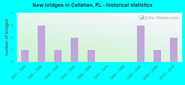
- New bridges - historical statistics
- 11920-1929
- 31930-1939
- 11940-1949
- 21950-1959
- 11960-1969
- 31990-1999
- 12000-2009
- 22010-2019

- Reconstructed bridges - Historical Statistics
- 21970-1979
- 21980-1989


- Bridge Condition - Deck
- 80.0%Good
- 10.0%Satisfactory
- 10.0%Fair

- Bridge Condition - Superstructure
- 10.0%Very good
- 70.0%Good
- 10.0%Satisfactory
- 10.0%Fair

- Bridge Condition - Substructure
- 60.0%Good
- 20.0%Satisfactory
- 20.0%Fair

- Bridge Condition - Channel
- 15.4%Very good
- 38.5%Good
- 38.5%Satisfactory
- 7.7%Fair
Find on map >> Show street view
Structure Number: 740014, Location: 1.9 MI. N. OF SR-200 (Lat: 30.588411, Lng: -81.830203), Route carried "on" structure: US 1, Year Built: 1924, Year Reconstructed: 1989, Status: Open, Structure Length: 1.28m (4.20ft), Average Daily Traffic: 5,300 (year 2020), Truck Traffic: 16%, Average Future Daily Traffic: 9,196 (year 2042), Design Load: H 15, Features Intersected: CAR SEAT CREEK
Minimum Vertical Clearance: 30+ m (98+ ft), Kilometerpoint: 10.440, Lanes on structure: 2, Base Highway Network: Yes, Owner: State Highway Agency, Approaching Roadway Width: 9.1m (29.9ft), Material/Design: Concrete, Design/Construction: Slab, Number Of Spans In Main Unit: 2, Length of Maximum Span: 6.1m (20.0ft), Curb-To-Curb Width: 9.1m (29.9ft), Out-to-Out Width: 17.4m (57.1ft)
Condition: Deck: Good, Superstructure: Good, Substructure: Satisfactory, Channel: Satisfactory, Operating Rating: 62.0 metric tons, Method Used To Determine Operating Rating: Load Factor (LF), Inventory Rating: 37.2 metric tons, Method Used To Determine Inventory Rating: Load Factor (LF), Structural Evaluation: Equal to present minimum criteria, Deck Geometry: Meets minimum limits, Waterway Adequacy: Equal to present desirable criteria, Approach Roadway Alignment: Equal to present desirable criteria, Designated Inspection Frequency: Every 24 months, Inspection Date: June 2020, Deck Structure Type: Concrete Cast-file-Place, Wearing Surface/Protective System: Wearing Surface: Bituminous
Find on map >> Show street view
Structure Number: 740043, Location: 0.5 MI. E. OF CALLAHAN (Lat: 30.559914, Lng: -81.819472), Route carried "on" structure: State highway 115, Year Built: 1948, Status: Open, Structure Length: 3.20m (10.50ft), Average Daily Traffic: 9,900 (year 2020), Truck Traffic: 6%, Average Future Daily Traffic: 17,176 (year 2042), Design Load: HS 20, Features Intersected: CUSHING CREEK
Minimum Vertical Clearance: 30+ m (98+ ft), Kilometerpoint: 7.588, Lanes on structure: 2, Owner: State Highway Agency, Approaching Roadway Width: 10.8m (35.4ft), Material/Design: Concrete, Design/Construction: Slab, Number Of Spans In Main Unit: 7, Length of Maximum Span: 4.6m (15.1ft), Curb-To-Curb Width: 8.4m (27.6ft), Out-to-Out Width: 9.6m (31.5ft)
Condition: Deck: Good, Superstructure: Good, Substructure: Satisfactory, Channel: Satisfactory, Operating Rating: 32.7 metric tons, Method Used To Determine Operating Rating: Load Factor (LF), Inventory Rating: 19.0 metric tons, Method Used To Determine Inventory Rating: Load Factor (LF), Structural Evaluation: Meets minimum limits, Deck Geometry: High priority of replacement, Waterway Adequacy: Equal to present desirable criteria, Approach Roadway Alignment: Equal to present desirable criteria, Length Of Structure Improvement: 3.20m (10.50ft), Designated Inspection Frequency: Every 24 months, Inspection Date: April 2021, Bridge Improvement Cost: $141,000, Roadway Improvement Cost: $14,000, Total Project Cost: $215,000, Deck Structure Type: Concrete Cast-file-Place
Find on map >> Show street view
Structure Number: 740046, Location: 1.3 MI NORTHWEST OF US 1 (Lat: 30.581472, Lng: -81.850000), Route carried "on" structure: County highway 115, Year Built: 1954, Status: Open, Structure Length: 1.19m (3.90ft), Average Daily Traffic: 2,500 (year 2020), Truck Traffic: 4%, Average Future Daily Traffic: 4,338 (year 2042), Features Intersected: LITTLE MILLS CREEK
Minimum Vertical Clearance: 30+ m (98+ ft), Kilometerpoint: 25.246, Lanes on structure: 2, Owner: County Highway Agency, Approaching Roadway Width: 5.6m (18.4ft), Material/Design: Steel, Design/Construction: Culvert, Number Of Spans In Main Unit: 3, Length of Maximum Span: 3.6m (11.8ft)
Condition: Channel: Satisfactory, Culverts: Satisfactory, Inventory Rating: 73.9 metric tons, Method Used To Determine Inventory Rating: Load Factor (LF), Structural Evaluation: Equal to present minimum criteria, Waterway Adequacy: Equal to present desirable criteria, Approach Roadway Alignment: Better than present minimum criteria, Designated Inspection Frequency: Every 24 months, Inspection Date: June 2020
Find on map >> Show street view
Structure Number: 740056, Location: 1.8 MI. N. OF SR-200 (Lat: 30.587019, Lng: -81.830561), Route carried "on" structure: US 1, Year Built: 1954, Year Reconstructed: 1989, Status: Open, Structure Length: 0.76m (2.49ft), Average Daily Traffic: 10,600 (year 2020), Truck Traffic: 16%, Average Future Daily Traffic: 18,391 (year 2042), Design Load: H 15, Features Intersected: KATIE CREEK
Minimum Vertical Clearance: 30+ m (98+ ft), Kilometerpoint: 10.285, Lanes on structure: 4, Base Highway Network: Yes, Owner: State Highway Agency, Approaching Roadway Width: 18.9m (62.0ft), Skew: 10 degrees, Material/Design: Concrete, Design/Construction: Culvert, Number Of Spans In Main Unit: 3, Length of Maximum Span: 2.4m (7.9ft)
Condition: Channel: Good, Culverts: Satisfactory, Operating Rating: 49.0 metric tons, Method Used To Determine Operating Rating: Load Factor (LF), Inventory Rating: 29.4 metric tons, Method Used To Determine Inventory Rating: Load Factor (LF), Structural Evaluation: Equal to present minimum criteria, Waterway Adequacy: Equal to present minimum criteria, Approach Roadway Alignment: Equal to present desirable criteria, Designated Inspection Frequency: Every 24 months, Inspection Date: June 2020
Find on map >> Show street view
Structure Number: 740073, Location: 2.3 MI NW OF US 1 (Lat: 30.591611, Lng: -81.860972), Route carried "on" structure: County highway 115, Year Built: 1938, Status: Open, Structure Length: 0.63m (2.07ft), Average Daily Traffic: 2,500 (year 2020), Truck Traffic: 4%, Average Future Daily Traffic: 4,338 (year 2042), Features Intersected: LITTLE MILLS CREEK
Minimum Vertical Clearance: 30+ m (98+ ft), Kilometerpoint: 23.617, Lanes on structure: 2, Owner: County Highway Agency, Approaching Roadway Width: 5.6m (18.4ft), Material/Design: Concrete, Design/Construction: Culvert, Number Of Spans In Main Unit: 2, Length of Maximum Span: 3.1m (10.2ft)
Condition: Channel: Fair, Culverts: Satisfactory, Operating Rating: 63.0 metric tons, Method Used To Determine Operating Rating: Load and Resistance Factor (LRFR), Inventory Rating: 40.5 metric tons, Method Used To Determine Inventory Rating: Load and Resistance Factor (LRFR), Structural Evaluation: Equal to present minimum criteria, Waterway Adequacy: Better than present minimum criteria, Approach Roadway Alignment: Equal to present desirable criteria, Designated Inspection Frequency: Every 24 months, Underwater Inspection Frequency: Every 24 months, Inspection Date: June 2020, Underwater Inspection Date: June 2020
Find on map >> Show street view
Structure Number: 740079, Location: 1.9 MI. N. OF SR-200 (Lat: 30.588375, Lng: -81.830036), Route carried "on" structure: US 1, Year Built: 1960, Status: Open, Structure Length: 1.31m (4.30ft), Average Daily Traffic: 5,300 (year 2020), Truck Traffic: 16%, Average Future Daily Traffic: 9,196 (year 2042), Design Load: H 15, Features Intersected: CAR SEAT CREEK
Minimum Vertical Clearance: 30+ m (98+ ft), Kilometerpoint: 10.440, Lanes on structure: 2, Base Highway Network: Yes, Owner: State Highway Agency, Approaching Roadway Width: 9.4m (30.8ft), Material/Design: Concrete, Design/Construction: Culvert, Number Of Spans In Main Unit: 4, Length of Maximum Span: 3.0m (9.8ft)
Condition: Channel: Satisfactory, Culverts: Satisfactory, Operating Rating: 55.2 metric tons, Method Used To Determine Operating Rating: Load and Resistance Factor (LRFR), Inventory Rating: 42.5 metric tons, Method Used To Determine Inventory Rating: Load and Resistance Factor (LRFR), Structural Evaluation: Equal to present minimum criteria, Waterway Adequacy: Better than present minimum criteria, Approach Roadway Alignment: Equal to present desirable criteria, Designated Inspection Frequency: Every 24 months, Inspection Date: June 2020
Find on map >> Show street view
Structure Number: 740102, Location: US-301/CSXRR IN CALLAHAN (Lat: 30.557869, Lng: -81.835903), Route carried "on" structure: US 301, Year Built: 2000, Status: Open, Structure Length: 5.18m (16.99ft), Average Daily Traffic: 6,700 (year 2020), Truck Traffic: 33%, Average Future Daily Traffic: 11,624 (year 2042), Design Load: HS 20+Mod, Features Intersected: CSXRR
Minimum Vertical Clearance: 30+ m (98+ ft), Kilometerpoint: 0.521, Lanes on structure: 4, Base Highway Network: Yes, Owner: State Highway Agency, Approaching Roadway Width: 20.7m (67.9ft), Skew: 1 degrees, Material/Design: Prestressed concrete, Design/Construction: Stringer/Multi-beam, Number Of Spans In Main Unit: 3, Length of Maximum Span: 19.2m (63.0ft), Curb or Sidewalk Widths: Left: 1.8m (5.9ft), Right: 1.8m (5.9ft), Curb-To-Curb Width: 20.7m (67.9ft), Out-to-Out Width: 25.3m (83.0ft)
Condition: Deck: Good, Superstructure: Very good, Substructure: Good, Operating Rating: 48.7 metric tons, Method Used To Determine Operating Rating: Load and Resistance Factor (LRFR), Inventory Rating: 37.6 metric tons, Method Used To Determine Inventory Rating: Load and Resistance Factor (LRFR), Structural Evaluation: Better than present minimum criteria, Deck Geometry: Superior to present desirable criteria, Underclear: Superior to present desirable criteria, Approach Roadway Alignment: Equal to present desirable criteria, Designated Inspection Frequency: Every 24 months, Inspection Date: June 2020, Deck Structure Type: Concrete Cast-file-Place
Find on map >> Show street view
Structure Number: 740103, Location: CALLAHAN N. CITY LIMITS (Lat: 30.566411, Lng: -81.833378), Route carried "on" structure: US 1, Year Built: 1992, Status: Open, Structure Length: 5.06m (16.60ft), Average Daily Traffic: 18,100 (year 2020), Truck Traffic: 18%, Average Future Daily Traffic: 31,404 (year 2042), Design Load: HS 20, Features Intersected: ALLIGATOR CREEK
Minimum Vertical Clearance: 30+ m (98+ ft), Kilometerpoint: 7.852, Lanes on structure: 4, Base Highway Network: Yes, Owner: State Highway Agency, Approaching Roadway Width: 18.4m (60.4ft), Material/Design: Concrete, Design/Construction: Slab, Number Of Spans In Main Unit: 7, Length of Maximum Span: 7.6m (24.9ft), Curb or Sidewalk Widths: Left: 2.1m (6.9ft), Right: 2.1m (6.9ft), Curb-To-Curb Width: 19.5m (64.0ft), Out-to-Out Width: 24.7m (81.0ft)
Condition: Deck: Good, Superstructure: Good, Substructure: Good, Channel: Good, Operating Rating: 70.8 metric tons, Method Used To Determine Operating Rating: Load Factor (LF), Inventory Rating: 42.6 metric tons, Method Used To Determine Inventory Rating: Load Factor (LF), Structural Evaluation: Better than present minimum criteria, Deck Geometry: Better than present minimum criteria, Waterway Adequacy: Equal to present desirable criteria, Approach Roadway Alignment: Equal to present desirable criteria, Designated Inspection Frequency: Every 24 months, Inspection Date: April 2021, Deck Structure Type: Concrete Cast-file-Place
Find on map >> Show street view
Structure Number: 740108, Location: 0.8 MILE N. OF US-301 (Lat: 30.577697, Lng: -81.833633), Route carried "on" structure: US 1, Year Built: 1998, Status: Open, Structure Length: 2.93m (9.61ft), Average Daily Traffic: 5,300 (year 2020), Truck Traffic: 16%, Average Future Daily Traffic: 9,196 (year 2042), Design Load: HS 20, Features Intersected: LITTLE MILLS CREEK
Minimum Vertical Clearance: 30+ m (98+ ft), Kilometerpoint: 9.199, Lanes on structure: 2, Base Highway Network: Yes, Owner: State Highway Agency, Approaching Roadway Width: 9.8m (32.2ft), Material/Design: Concrete continuous, Design/Construction: Slab, Number Of Spans In Main Unit: 4, Length of Maximum Span: 7.4m (24.3ft), Curb-To-Curb Width: 12.0m (39.4ft), Out-to-Out Width: 12.9m (42.3ft)
Condition: Deck: Good, Superstructure: Good, Substructure: Good, Channel: Good, Operating Rating: 81.6 metric tons, Method Used To Determine Operating Rating: Load Factor (LF), Inventory Rating: 48.9 metric tons, Method Used To Determine Inventory Rating: Load Factor (LF), Structural Evaluation: Better than present minimum criteria, Deck Geometry: Better than present minimum criteria, Waterway Adequacy: Equal to present desirable criteria, Approach Roadway Alignment: Equal to present desirable criteria, Designated Inspection Frequency: Every 24 months, Inspection Date: April 2021, Deck Structure Type: Concrete Cast-file-Place
Find on map >> Show street view
Structure Number: 740109, Location: 0.8 MILE N. OF US-301 (Lat: 30.577675, Lng: -81.833461), Route carried "on" structure: US 1, Year Built: 1998, Status: Open, Structure Length: 2.93m (9.61ft), Average Daily Traffic: 5,300 (year 2020), Truck Traffic: 16%, Average Future Daily Traffic: 9,196 (year 2042), Design Load: HS 20, Features Intersected: LITTLE MILLS CREEK
Minimum Vertical Clearance: 30+ m (98+ ft), Kilometerpoint: 9.199, Lanes on structure: 2, Base Highway Network: Yes, Owner: State Highway Agency, Approaching Roadway Width: 9.8m (32.2ft), Material/Design: Concrete continuous, Design/Construction: Slab, Number Of Spans In Main Unit: 4, Length of Maximum Span: 7.4m (24.3ft), Curb-To-Curb Width: 12.0m (39.4ft), Out-to-Out Width: 12.9m (42.3ft)
Condition: Deck: Good, Superstructure: Good, Substructure: Good, Channel: Good, Operating Rating: 81.6 metric tons, Method Used To Determine Operating Rating: Load Factor (LF), Inventory Rating: 48.9 metric tons, Method Used To Determine Inventory Rating: Load Factor (LF), Structural Evaluation: Better than present minimum criteria, Deck Geometry: Better than present minimum criteria, Waterway Adequacy: Equal to present desirable criteria, Approach Roadway Alignment: Equal to present desirable criteria, Designated Inspection Frequency: Every 24 months, Inspection Date: April 2021, Deck Structure Type: Concrete Cast-file-Place
Find on map >> Show street view
Structure Number: 740123, Location: 2 MI. S. OF US-1 (Lat: 30.546361, Lng: -81.847250), Route carried "on" structure: US 301, Year Built: 2015, Status: Open, Structure Length: 3.51m (11.52ft), Average Daily Traffic: 3,050 (year 2020), Truck Traffic: 33%, Average Future Daily Traffic: 5,292 (year 2042), Design Load: HL 93, Features Intersected: FUNKS CREEK
Minimum Vertical Clearance: 30+ m (98+ ft), Kilometerpoint: 22.557, Lanes on structure: 2, Base Highway Network: Yes, Owner: State Highway Agency, Approaching Roadway Width: 9.9m (32.5ft), Skew: 4 degrees, Material/Design: Concrete, Design/Construction: Slab, Number Of Spans In Main Unit: 3, Length of Maximum Span: 11.8m (38.7ft), Curb-To-Curb Width: 12.2m (40.0ft), Out-to-Out Width: 13.1m (43.0ft)
Condition: Deck: Good, Superstructure: Good, Substructure: Good, Channel: Very good, Operating Rating: 44.5 metric tons, Method Used To Determine Operating Rating: Load and Resistance Factor (LRFR), Inventory Rating: 34.4 metric tons, Method Used To Determine Inventory Rating: Load and Resistance Factor (LRFR), Structural Evaluation: Better than present minimum criteria, Deck Geometry: Better than present minimum criteria, Waterway Adequacy: Equal to present desirable criteria, Approach Roadway Alignment: Equal to present desirable criteria, Designated Inspection Frequency: Every 24 months, Underwater Inspection Frequency: Every 24 months, Inspection Date: January 2022, Underwater Inspection Date: January 2022, Deck Structure Type: Concrete Cast-file-Place
Find on map >> Show street view
Structure Number: 740124, Location: 2 MI. S. OF US-1 (Lat: 30.546122, Lng: -81.847114), Route carried "on" structure: US 301, Year Built: 2015, Status: Open, Structure Length: 3.51m (11.52ft), Average Daily Traffic: 3,050 (year 2020), Truck Traffic: 33%, Average Future Daily Traffic: 5,292 (year 2042), Design Load: HL 93, Features Intersected: FUNKS CREEK
Minimum Vertical Clearance: 30+ m (98+ ft), Kilometerpoint: 22.557, Lanes on structure: 2, Base Highway Network: Yes, Owner: State Highway Agency, Approaching Roadway Width: 9.9m (32.5ft), Skew: 4 degrees, Material/Design: Concrete, Design/Construction: Slab, Number Of Spans In Main Unit: 3, Length of Maximum Span: 11.8m (38.7ft), Curb-To-Curb Width: 12.2m (40.0ft), Out-to-Out Width: 13.1m (43.0ft)
Condition: Deck: Good, Superstructure: Good, Substructure: Good, Channel: Very good, Operating Rating: 44.5 metric tons, Method Used To Determine Operating Rating: Load and Resistance Factor (LRFR), Inventory Rating: 34.4 metric tons, Method Used To Determine Inventory Rating: Load and Resistance Factor (LRFR), Structural Evaluation: Better than present minimum criteria, Deck Geometry: Better than present minimum criteria, Waterway Adequacy: Equal to present desirable criteria, Approach Roadway Alignment: Equal to present desirable criteria, Designated Inspection Frequency: Every 24 months, Underwater Inspection Frequency: Every 24 months, Inspection Date: January 2022, Underwater Inspection Date: January 2022, Deck Structure Type: Concrete Cast-file-Place
Find on map >> Show street view
Structure Number: 744006, Location: 0.1 MI N OF ROBERTS RD (Lat: 30.577889, Lng: -81.837000), Route carried "on" structure: County highway , Year Built: 1931, Year Reconstructed: 1982, Status: Posted for load-capacity, Structure Length: 1.22m (4.00ft), Average Daily Traffic: 31 (year 2020), Average Future Daily Traffic: 54 (year 2042), Features Intersected: LITTLE MILLS CREEK, Facility Carried by Structure: HILL ROAD
Minimum Vertical Clearance: 30+ m (98+ ft), Kilometerpoint: 0.200, Lanes on structure: 2, Owner: County Highway Agency, Approaching Roadway Width: 4.5m (14.8ft), Skew: 4 degrees, Material/Design: Wood or Timber, Design/Construction: Slab, Number Of Spans In Main Unit: 2, Length of Maximum Span: 6.1m (20.0ft), Curb or Sidewalk Widths: Left: 0.1m (0.3ft), Right: 0.1m (0.3ft), Curb-To-Curb Width: 6.9m (22.6ft), Out-to-Out Width: 7.3m (24.0ft)
Condition: Deck: Satisfactory, Superstructure: Satisfactory, Substructure: Fair, Channel: Satisfactory, Operating Rating: 71.6 metric tons, Method Used To Determine Operating Rating: Allowable Stress (AS), Inventory Rating: 52.7 metric tons, Method Used To Determine Inventory Rating: Allowable Stress (AS), Structural Evaluation: Somewhat better than minimum adequacy, Deck Geometry: Somewhat better than minimum adequacy, Waterway Adequacy: Equal to present minimum criteria, Approach Roadway Alignment: Equal to present minimum criteria, Length Of Structure Improvement: 0.91m (2.99ft), Designated Inspection Frequency: Every 24 months, Inspection Date: June 2020, Bridge Improvement Cost: $18,000, Roadway Improvement Cost: $2,000, Total Project Cost: $22,000, Deck Structure Type: Wood or Timber
Find on map >> Show street view
Structure Number: 74401, Location: 0.2 MI EAST OF SR 200 (Lat: 30.568444, Lng: -81.821111), Route carried "on" structure: County highway , Year Built: 1931, Year Reconstructed: 1977, Status: Posted for load-capacity, Structure Length: 2.44m (8.01ft), Average Daily Traffic: 101 (year 2020), Truck Traffic: 10%, Average Future Daily Traffic: 175 (year 2042), Design Load: HL 93, Features Intersected: CUSHING CREEK, Facility Carried by Structure: STRATTON ROAD
Minimum Vertical Clearance: 30+ m (98+ ft), Kilometerpoint: 0.409, Lanes on structure: 2, Owner: County Highway Agency, Approaching Roadway Width: 5.7m (18.7ft), Material/Design: Prestressed concrete, Design/Construction: Slab, Number Of Spans In Main Unit: 4, Length of Maximum Span: 6.1m (20.0ft), Curb-To-Curb Width: 6.1m (20.0ft), Out-to-Out Width: 7.0m (23.0ft)
Condition: Deck: Fair, Superstructure: Fair, Substructure: Fair, Channel: Good, Operating Rating: 30.0 metric tons, Method Used To Determine Operating Rating: Load and Resistance Factor (LRFR), Inventory Rating: 18.6 metric tons, Method Used To Determine Inventory Rating: Load and Resistance Factor (LRFR), Structural Evaluation: Somewhat better than minimum adequacy, Deck Geometry: Meets minimum limits, Waterway Adequacy: Equal to present desirable criteria, Approach Roadway Alignment: Equal to present desirable criteria, Length Of Structure Improvement: 3.25m (10.66ft), Designated Inspection Frequency: Every 24 months, Underwater Inspection Frequency: Every 24 months, Inspection Date: June 2020, Underwater Inspection Date: June 2020, Bridge Improvement Cost: $300,000, Roadway Improvement Cost: $30,000, Total Project Cost: $450,000, Deck Structure Type: Concrete Precast Panels, Wearing Surface/Protective System: Wearing Surface: Bituminous