Bridge Statistics for Calhan, Colorado (CO)
Condition, Traffic, Stress, Structural Evaluation, Project Costs
- National Bridge Inventory (NBI) Statistics
- 16Number of bridges
- 102ft / 31.5mTotal length
- $137,000Total costs
- 56,021Total average daily traffic
- 4,069Total average daily truck traffic
- 68,388Total future (year 2040) average daily traffic
- National Bridge Inventory (NBI) Registered Bridges for Calhan
- No street view available for this location
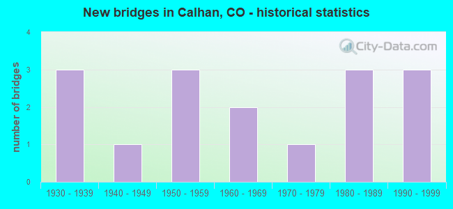
- New bridges - historical statistics
- 31930-1939
- 11940-1949
- 31950-1959
- 21960-1969
- 11970-1979
- 31980-1989
- 31990-1999

- Reconstructed bridges - Historical Statistics
- 11980-1989
- 11990-1999


- Bridge Condition - Deck
- 8.3%Very good
- 16.7%Good
- 66.7%Satisfactory
- 8.3%Serious

- Bridge Condition - Superstructure
- 8.3%Very good
- 83.3%Satisfactory
- 8.3%Poor

- Bridge Condition - Substructure
- 8.3%Very good
- 58.3%Satisfactory
- 25.0%Fair
- 8.3%Poor

- Bridge Condition - Channel
- 26.7%Very good
- 33.3%Good
- 40.0%Satisfactory

- Bridge Condition - Culverts
- 50.0%Good
- 25.0%Fair
- 25.0%Poor
Find on map >> Show street view
Structure Number: CALHAN-8TH ST., Location: WEST OF BIJOU AVENUE (Lat: 39.033997, Lng: -104.303275), Route carried "on" structure: City street , Year Built: 1949, Status: Open, Structure Length: 0.82m (2.69ft), Average Daily Traffic: 205 (year 2020), Truck Traffic: 5%, Average Future Daily Traffic: 268 (year 2040), Features Intersected: BIG SANDY CREEK TRIB, Facility Carried by Structure: 8TH STREET
Minimum Vertical Clearance: 30+ m (98+ ft), Kilometerpoint: 0.756, Lanes on structure: 2, Owner: City or Municipal Highway Agency, Approaching Roadway Width: 7.9m (25.9ft), Material/Design: Concrete, Design/Construction: Tee Beam, Number Of Spans In Main Unit: 1, Length of Maximum Span: 7.3m (24.0ft), Curb or Sidewalk Widths: Left: 1.5m (4.9ft), Right: 0.0m, Curb-To-Curb Width: 9.7m (31.8ft), Out-to-Out Width: 11.2m (36.7ft)
Condition: Deck: Satisfactory, Superstructure: Satisfactory, Substructure: Fair, Channel: Good, Operating Rating: 36.3 metric tons, Method Used To Determine Operating Rating: Field evaluation and documented engineering judgment, Inventory Rating: 32.7 metric tons, Method Used To Determine Inventory Rating: Field evaluation and documented engineering judgment, Structural Evaluation: Somewhat better than minimum adequacy, Deck Geometry: Equal to present minimum criteria, Waterway Adequacy: Equal to present desirable criteria, Approach Roadway Alignment: Equal to present desirable criteria, Designated Inspection Frequency: Every 24 months, Inspection Date: Febuary 2022, Deck Structure Type: Concrete Cast-file-Place, Wearing Surface/Protective System: Wearing Surface: Bituminous
Find on map >> Show street view
Structure Number: EPC0046-01.60A, Location: 0.4 MILES NORTH OF CALHAN (Lat: 39.040833, Lng: -104.300833), Route carried "on" structure: County highway , Year Built: 1984, Status: Open, Structure Length: 1.24m (4.07ft), Average Daily Traffic: 350 (year 2020), Truck Traffic: 4%, Average Future Daily Traffic: 458 (year 2040), Features Intersected: BIG SANDY CREEK TRIB, Facility Carried by Structure: MCCLASKEY ROAD
Minimum Vertical Clearance: 30+ m (98+ ft), Kilometerpoint: 0.169, Lanes on structure: 2, Owner: County Highway Agency, Approaching Roadway Width: 7.6m (24.9ft), Material/Design: Concrete, Design/Construction: Culvert, Number Of Spans In Main Unit: 5, Length of Maximum Span: 2.1m (6.9ft), Curb-To-Curb Width: 9.1m (29.9ft), Out-to-Out Width: 11.0m (36.1ft)
Condition: Channel: Satisfactory, Culverts: Poor, Operating Rating: 43.9 metric tons, Method Used To Determine Operating Rating: Load Factor (LF), Inventory Rating: 26.3 metric tons, Method Used To Determine Inventory Rating: Load Factor (LF), Structural Evaluation: Meets minimum limits, Deck Geometry: Equal to present minimum criteria, Waterway Adequacy: Better than present minimum criteria, Approach Roadway Alignment: Equal to present desirable criteria, Designated Inspection Frequency: Every 24 months, Inspection Date: Febuary 2022
Find on map >> Show street view
Structure Number: EPC0129-09.07, Location: 1.6 MI S OF CALHAN (Lat: 39.013611, Lng: -104.293889), Route carried "on" structure: County highway , Year Built: 1975, Status: Posted for load, Structure Length: 2.95m (9.68ft), Average Daily Traffic: 707 (year 2021), Truck Traffic: 9%, Average Future Daily Traffic: 926 (year 2041), Features Intersected: BIG SANDY CREEK TRIB., Facility Carried by Structure: CALHAN HIGHWAY
Minimum Vertical Clearance: 30+ m (98+ ft), Kilometerpoint: 14.726, Lanes on structure: 2, Base Highway Network: Yes, Owner: County Highway Agency, Approaching Roadway Width: 7.3m (24.0ft), Material/Design: Prestressed concrete, Design/Construction: Tee Beam, Number Of Spans In Main Unit: 2, Length of Maximum Span: 14.3m (46.9ft), Curb-To-Curb Width: 9.0m (29.5ft), Out-to-Out Width: 9.1m (29.9ft)
Condition: Deck: Serious, Superstructure: Poor, Substructure: Poor, Channel: Good, Operating Rating: 18.1 metric tons, Method Used To Determine Operating Rating: Load Factor (LF), Inventory Rating: 10.8 metric tons, Method Used To Determine Inventory Rating: Load Factor (LF), Structural Evaluation: High priority of corrective action, Deck Geometry: Somewhat better than minimum adequacy, Waterway Adequacy: Equal to present desirable criteria, Approach Roadway Alignment: Equal to present desirable criteria, Designated Inspection Frequency: Every 12 months, Inspection Date: Febuary 2022, Deck Structure Type: Other, Wearing Surface/Protective System: Wearing Surface: Bituminous
Find on map >> Show street view
Structure Number: EPC0129-12.20A, Location: 1.5 MI N OF CALHAN (Lat: 39.059167, Lng: -104.293333), Route carried "on" structure: County highway , Year Built: 1986, Status: Open, Structure Length: 1.86m (6.10ft), Average Daily Traffic: 2,780 (year 2020), Truck Traffic: 2%, Average Future Daily Traffic: 3,641 (year 2040), Features Intersected: BIG SANDY CREEK, Facility Carried by Structure: CALHAN HWY
Minimum Vertical Clearance: 30+ m (98+ ft), Kilometerpoint: 2.159, Lanes on structure: 2, Owner: County Highway Agency, Approaching Roadway Width: 7.5m (24.6ft), Material/Design: Steel continuous, Design/Construction: Stringer/Multi-beam, Number Of Spans In Main Unit: 2, Length of Maximum Span: 8.8m (28.9ft), Curb-To-Curb Width: 12.1m (39.7ft), Out-to-Out Width: 12.2m (40.0ft)
Condition: Deck: Very good, Superstructure: Satisfactory, Substructure: Satisfactory, Channel: Good, Operating Rating: 49.8 metric tons, Method Used To Determine Operating Rating: Load Factor (LF), Inventory Rating: 29.8 metric tons, Method Used To Determine Inventory Rating: Load Factor (LF), Structural Evaluation: Equal to present minimum criteria, Deck Geometry: Somewhat better than minimum adequacy, Waterway Adequacy: Better than present minimum criteria, Approach Roadway Alignment: Equal to present desirable criteria, Designated Inspection Frequency: Every 24 months, Inspection Date: Febuary 2022, Deck Structure Type: Corrugated Steel, Wearing Surface/Protective System: Wearing Surface: Bituminous
Find on map >> Show street view
Structure Number: EPC0129-13.93, Location: 3.0 MI N OF CALHAN (Lat: 39.083056, Lng: -104.293056), Route carried "on" structure: County highway , Year Built: 1955, Status: Open, Structure Length: 3.63m (11.91ft), Average Daily Traffic: 2,753 (year 2020), Truck Traffic: 2%, Average Future Daily Traffic: 3,606 (year 2040), Features Intersected: BIG SANDY CREEK, Facility Carried by Structure: CALHAN HWY
Minimum Vertical Clearance: 30+ m (98+ ft), Kilometerpoint: 4.831, Lanes on structure: 2, Owner: County Highway Agency, Approaching Roadway Width: 7.6m (24.9ft), Material/Design: Steel continuous, Design/Construction: Stringer/Multi-beam, Number Of Spans In Main Unit: 6, Length of Maximum Span: 5.9m (19.4ft), Curb-To-Curb Width: 9.0m (29.5ft), Out-to-Out Width: 9.1m (29.9ft)
Condition: Deck: Satisfactory, Superstructure: Satisfactory, Substructure: Satisfactory, Channel: Satisfactory, Inventory Rating: 70.1 metric tons, Method Used To Determine Inventory Rating: Load Factor (LF), Structural Evaluation: Equal to present minimum criteria, Deck Geometry: Meets minimum limits, Waterway Adequacy: Equal to present minimum criteria, Approach Roadway Alignment: Equal to present desirable criteria, Designated Inspection Frequency: Every 24 months, Inspection Date: Febuary 2020, Deck Structure Type: Corrugated Steel, Wearing Surface/Protective System: Wearing Surface: Bituminous
Find on map >> Show street view
Structure Number: EPC0129-14.9, Location: 4.1 MI N OF CALHAN (Lat: 39.096944, Lng: -104.293056), Route carried "on" structure: County highway , Year Built: 1965, Year Reconstructed: 1996, Status: Open, Structure Length: 0.91m (2.99ft), Average Daily Traffic: 2,879 (year 2020), Truck Traffic: 2%, Average Future Daily Traffic: 3,772 (year 2040), Features Intersected: BIG SANDY CREEK TRIB., Facility Carried by Structure: CALHAN HIGHWAY
Minimum Vertical Clearance: 30+ m (98+ ft), Kilometerpoint: 6.260, Lanes on structure: 2, Owner: County Highway Agency, Approaching Roadway Width: 7.3m (24.0ft), Material/Design: Steel, Design/Construction: Stringer/Multi-beam, Number Of Spans In Main Unit: 1, Length of Maximum Span: 8.5m (27.9ft), Curb-To-Curb Width: 9.1m (29.9ft), Out-to-Out Width: 9.1m (29.9ft)
Condition: Deck: Satisfactory, Superstructure: Satisfactory, Substructure: Satisfactory, Channel: Good, Operating Rating: 68.1 metric tons, Method Used To Determine Operating Rating: Load Factor (LF), Inventory Rating: 40.9 metric tons, Method Used To Determine Inventory Rating: Load Factor (LF), Structural Evaluation: Equal to present minimum criteria, Deck Geometry: Meets minimum limits, Waterway Adequacy: Equal to present desirable criteria, Approach Roadway Alignment: Equal to present desirable criteria, Designated Inspection Frequency: Every 24 months, Inspection Date: Febuary 2020, Deck Structure Type: Corrugated Steel, Wearing Surface/Protective System: Wearing Surface: Bituminous
Find on map >> Show street view
Structure Number: EPC0503-01.44, Location: 1.3 MI S OF DZURIS ROAD (Lat: 39.077778, Lng: -104.348889), Route carried "on" structure: County highway , Year Built: 1957, Year Reconstructed: 1994, Status: Open, Structure Length: 2.47m (8.10ft), Average Daily Traffic: 167 (year 2020), Average Future Daily Traffic: 219 (year 2040), Features Intersected: BIG SANDY CREEK, Facility Carried by Structure: FAIRPLAY ROAD
Minimum Vertical Clearance: 30+ m (98+ ft), Kilometerpoint: 2.529, Lanes on structure: 2, Owner: County Highway Agency, Approaching Roadway Width: 6.7m (22.0ft), Material/Design: Steel continuous, Design/Construction: Stringer/Multi-beam, Number Of Spans In Main Unit: 5, Length of Maximum Span: 5.9m (19.4ft), Curb-To-Curb Width: 5.9m (19.4ft), Out-to-Out Width: 6.1m (20.0ft)
Condition: Deck: Good, Superstructure: Satisfactory, Substructure: Satisfactory, Channel: Satisfactory, Inventory Rating: 66.2 metric tons, Method Used To Determine Inventory Rating: Load Factor (LF), Structural Evaluation: Equal to present minimum criteria, Deck Geometry: High priority of corrective action, Waterway Adequacy: Equal to present desirable criteria, Approach Roadway Alignment: Equal to present desirable criteria, Designated Inspection Frequency: Every 24 months, Inspection Date: January 2022, Deck Structure Type: Corrugated Steel, Wearing Surface/Protective System: Wearing Surface: Gravel
Find on map >> Show street view
Structure Number: EPC0503-01.65, Location: 1.2 MI S OF DZURIS ROAD (Lat: 39.079722, Lng: -104.348889), Route carried "on" structure: County highway , Year Built: 1994, Status: Open, Structure Length: 1.04m (3.41ft), Average Daily Traffic: 169 (year 2020), Average Future Daily Traffic: 221 (year 2040), Features Intersected: BIG SANDY CREEK, Facility Carried by Structure: FAIRPLAY ROAD
Minimum Vertical Clearance: 30+ m (98+ ft), Kilometerpoint: 2.686, Lanes on structure: 2, Owner: County Highway Agency, Approaching Roadway Width: 7.0m (23.0ft), Material/Design: Steel, Design/Construction: Stringer/Multi-beam, Number Of Spans In Main Unit: 1, Length of Maximum Span: 10.0m (32.8ft), Curb-To-Curb Width: 6.0m (19.7ft), Out-to-Out Width: 6.1m (20.0ft)
Condition: Deck: Satisfactory, Superstructure: Satisfactory, Substructure: Satisfactory, Channel: Satisfactory, Operating Rating: 61.5 metric tons, Method Used To Determine Operating Rating: Load Factor (LF), Inventory Rating: 36.9 metric tons, Method Used To Determine Inventory Rating: Load Factor (LF), Structural Evaluation: Equal to present minimum criteria, Deck Geometry: High priority of corrective action, Waterway Adequacy: Equal to present desirable criteria, Approach Roadway Alignment: Equal to present desirable criteria, Length Of Structure Improvement: 1.04m (3.41ft), Designated Inspection Frequency: Every 24 months, Inspection Date: January 2022, Bridge Improvement Cost: $125,000, Roadway Improvement Cost: $12,000, Total Project Cost: $137,000 ( Estimate for 2014), Deck Structure Type: Corrugated Steel, Wearing Surface/Protective System: Wearing Surface: Gravel
Find on map >> Show street view
Structure Number: EPC0515-01.87A, Location: 1.87 MI N OF MCCLASKEY RD (Lat: 39.067222, Lng: -104.311944), Route carried "on" structure: County highway , Year Built: 1995, Status: Open, Structure Length: 0.84m (2.76ft), Average Daily Traffic: 60 (year 2020), Average Future Daily Traffic: 78 (year 2040), Design Load: HS 20, Features Intersected: BIG SANDY CREEK TRIB, Facility Carried by Structure: EURICH ROAD
Minimum Vertical Clearance: 30+ m (98+ ft), Kilometerpoint: 2.931, Lanes on structure: 2, Owner: County Highway Agency, Approaching Roadway Width: 7.6m (24.9ft), Material/Design: Steel, Design/Construction: Culvert, Number Of Spans In Main Unit: 4, Length of Maximum Span: 1.5m (4.9ft), Out-to-Out Width: 20.2m (66.3ft)
Condition: Channel: Good, Culverts: Good, Structural Evaluation: Better than present minimum criteria, Waterway Adequacy: Better than present minimum criteria, Approach Roadway Alignment: Equal to present desirable criteria, Designated Inspection Frequency: Every 24 months, Inspection Date: Febuary 2022
Find on map >> Show street view
Structure Number: EPC0515-02.87A, Location: 2.87 MI N OF MCCLASKEY RD (Lat: 39.081944, Lng: -104.311667), Route carried "on" structure: County highway , Year Built: 1995, Status: Open, Structure Length: 1.37m (4.49ft), Average Daily Traffic: 51 (year 2020), Average Future Daily Traffic: 67 (year 2040), Design Load: HS 20, Features Intersected: BIG SANDY CREEK, Facility Carried by Structure: EURICH ROAD
Minimum Vertical Clearance: 30+ m (98+ ft), Kilometerpoint: 4.631, Lanes on structure: 2, Owner: County Highway Agency, Approaching Roadway Width: 7.6m (24.9ft), Material/Design: Steel, Design/Construction: Culvert, Number Of Spans In Main Unit: 6, Length of Maximum Span: 1.5m (4.9ft), Out-to-Out Width: 20.3m (66.6ft)
Condition: Channel: Satisfactory, Culverts: Fair, Structural Evaluation: Somewhat better than minimum adequacy, Waterway Adequacy: Better than present minimum criteria, Approach Roadway Alignment: Equal to present desirable criteria, Designated Inspection Frequency: Every 24 months, Inspection Date: Febuary 2020
Find on map >> Show street view
Structure Number: H-03-BB, Location: 7.5 MI W OF JCT SH 65 (Lat: 39.117819, Lng: -108.359161), Route carried "on" structure: Interstate 70A, Year Built: 1963, Status: Open, Structure Length: 3.92m (12.86ft), Average Daily Traffic: 11,500 (year 2020), Truck Traffic: 13%, Average Future Daily Traffic: 15,410 (year 2040), Design Load: HS 20, Features Intersected: COUNTY ROAD 37.5, Facility Carried by Structure: I 70 ML WBND
Minimum Vertical Clearance: 30+ m (98+ ft), Kilometerpoint: 66.957, Lanes on structure: 2, Lanes under structure: 2, Base Highway Network: Yes, Owner: State Highway Agency, Approaching Roadway Width: 11.6m (38.1ft), Skew: 10 degrees, Material/Design: Concrete, Design/Construction: Tee Beam, Number Of Spans In Main Unit: 3, Length of Maximum Span: 15.3m (50.2ft), Curb-To-Curb Width: 11.6m (38.1ft), Out-to-Out Width: 12.8m (42.0ft)
Condition: Deck: Satisfactory, Superstructure: Satisfactory, Substructure: Satisfactory, Operating Rating: 58.5 metric tons, Method Used To Determine Operating Rating: Load Factor (LF), Inventory Rating: 35.0 metric tons, Method Used To Determine Inventory Rating: Load Factor (LF), Structural Evaluation: Equal to present minimum criteria, Deck Geometry: Equal to present minimum criteria, Underclear: Better than present minimum criteria, Approach Roadway Alignment: Equal to present desirable criteria, Designated Inspection Frequency: Every 24 months, Inspection Date: March 2020, Deck Structure Type: Concrete Cast-file-Place, Wearing Surface/Protective System: Wearing Surface: Bituminous
Find on map >> Show street view
Structure Number: H-03-BO, Location: IN CLIFTON (Lat: 39.079050, Lng: -108.459303), Route carried "on" structure: US 141B, Year Built: 1984, Status: Open, Structure Length: 1.89m (6.20ft), Average Daily Traffic: 15,000 (year 2020), Truck Traffic: 4%, Average Future Daily Traffic: 15,750 (year 2040), Design Load: HS 20+Mod, Features Intersected: GRAND VALLEY CANAL, Facility Carried by Structure: SH 141 ML
Minimum Vertical Clearance: 30+ m (98+ ft), Kilometerpoint: 7.686, Lanes on structure: 5, Base Highway Network: Yes, Owner: State Highway Agency, Approaching Roadway Width: 25.6m (84.0ft), Material/Design: Steel, Design/Construction: Stringer/Multi-beam, Number Of Spans In Main Unit: 1, Length of Maximum Span: 18.0m (59.1ft), Curb or Sidewalk Widths: Left: 1.4m (4.6ft), Right: 1.4m (4.6ft), Curb-To-Curb Width: 25.6m (84.0ft), Out-to-Out Width: 29.1m (95.5ft)
Condition: Deck: Good, Superstructure: Very good, Substructure: Very good, Channel: Very good, Operating Rating: 56.2 metric tons, Method Used To Determine Operating Rating: Load Factor (LF), Inventory Rating: 33.6 metric tons, Method Used To Determine Inventory Rating: Load Factor (LF), Structural Evaluation: Equal to present desirable criteria, Deck Geometry: Superior to present desirable criteria, Waterway Adequacy: Equal to present desirable criteria, Approach Roadway Alignment: Equal to present desirable criteria, Designated Inspection Frequency: Every 48 months, Inspection Date: Febuary 2020, Deck Structure Type: Concrete Cast-file-Place, Wearing Surface/Protective System: Wearing Surface: Bituminous, Membrane: Preformed Fabric
Find on map >> Show street view
Structure Number: H-19-J, Location: 1.4 MI E OF CALHAN (Lat: 39.040608, Lng: -104.277047), Route carried "on" structure: US 24G, Year Built: 1935, Status: Open, Structure Length: 2.27m (7.45ft), Average Daily Traffic: 4,200 (year 2020), Truck Traffic: 10%, Average Future Daily Traffic: 5,166 (year 2040), Design Load: H 15, Features Intersected: DRAW, Facility Carried by Structure: US 24 ML
Minimum Vertical Clearance: 30.45m (99.90ft), Kilometerpoint: 48.348, Lanes on structure: 2, Base Highway Network: Yes, Owner: State Highway Agency, Approaching Roadway Width: 12.2m (40.0ft), Material/Design: Wood or Timber, Design/Construction: Stringer/Multi-beam, Number Of Spans In Main Unit: 3, Length of Maximum Span: 8.2m (26.9ft), Curb-To-Curb Width: 8.8m (28.9ft), Out-to-Out Width: 9.1m (29.9ft)
Condition: Deck: Satisfactory, Superstructure: Satisfactory, Substructure: Fair, Channel: Very good, Operating Rating: 32.3 metric tons, Method Used To Determine Operating Rating: Load Factor (LF), Inventory Rating: 21.6 metric tons, Method Used To Determine Inventory Rating: Load Factor (LF), Structural Evaluation: Somewhat better than minimum adequacy, Deck Geometry: Meets minimum limits, Waterway Adequacy: Equal to present desirable criteria, Approach Roadway Alignment: Equal to present desirable criteria, Designated Inspection Frequency: Every 24 months, Inspection Date: Febuary 2021, Deck Structure Type: Wood or Timber, Wearing Surface/Protective System: Wearing Surface: Bituminous
Find on map >> Show street view
Structure Number: H-19-M, Location: 6.3 MI E OF PEYTON (Lat: 39.026186, Lng: -104.362869), Route carried "on" structure: US 24G, Year Built: 1959, Status: Open, Structure Length: 0.64m (2.10ft), Average Daily Traffic: 5,500 (year 2020), Truck Traffic: 8%, Average Future Daily Traffic: 6,820 (year 2040), Design Load: HS 20, Features Intersected: DRAW, Facility Carried by Structure: US 24 ML
Minimum Vertical Clearance: 30.45m (99.90ft), Kilometerpoint: 40.485, Lanes on structure: 2, Base Highway Network: Yes, Owner: State Highway Agency, Approaching Roadway Width: 13.4m (44.0ft), Material/Design: Concrete, Design/Construction: Culvert, Number Of Spans In Main Unit: 2, Length of Maximum Span: 3.0m (9.8ft), Out-to-Out Width: 19.8m (65.0ft)
Condition: Channel: Very good, Culverts: Good, Operating Rating: 81.6 metric tons, Method Used To Determine Operating Rating: Field evaluation and documented engineering judgment, Inventory Rating: 81.6 metric tons, Method Used To Determine Inventory Rating: Field evaluation and documented engineering judgment, Structural Evaluation: Better than present minimum criteria, Waterway Adequacy: Equal to present desirable criteria, Approach Roadway Alignment: Equal to present desirable criteria, Designated Inspection Frequency: Every 24 months, Inspection Date: Febuary 2021
Find on map >> Show street view
Structure Number: H-19-P, Location: 1.8 MI E OF CALHAN (Lat: 39.043631, Lng: -104.271394), Route carried "on" structure: US 24G, Year Built: 1935, Status: Open, Structure Length: 3.47m (11.38ft), Average Daily Traffic: 4,200 (year 2020), Truck Traffic: 10%, Average Future Daily Traffic: 5,166 (year 2040), Design Load: H 15, Features Intersected: DRAW, Facility Carried by Structure: US 24 ML
Minimum Vertical Clearance: 30.45m (99.90ft), Kilometerpoint: 49.621, Lanes on structure: 2, Base Highway Network: Yes, Owner: State Highway Agency, Approaching Roadway Width: 12.2m (40.0ft), Skew: 2 degrees, Material/Design: Wood or Timber, Design/Construction: Stringer/Multi-beam, Number Of Spans In Main Unit: 5, Length of Maximum Span: 6.9m (22.6ft), Curb-To-Curb Width: 8.8m (28.9ft), Out-to-Out Width: 9.1m (29.9ft)
Condition: Deck: Satisfactory, Superstructure: Satisfactory, Substructure: Fair, Channel: Satisfactory, Operating Rating: 40.8 metric tons, Method Used To Determine Operating Rating: Allowable Stress (AS), Inventory Rating: 27.8 metric tons, Method Used To Determine Inventory Rating: Allowable Stress (AS), Structural Evaluation: Somewhat better than minimum adequacy, Deck Geometry: Meets minimum limits, Waterway Adequacy: Equal to present desirable criteria, Approach Roadway Alignment: Equal to present desirable criteria, Designated Inspection Frequency: Every 24 months, Inspection Date: Febuary 2021, Deck Structure Type: Wood or Timber, Wearing Surface/Protective System: Wearing Surface: Bituminous
Find on map >> Show street view
Structure Number: H-19-Q, Location: CALHAN (Lat: 39.035908, Lng: -104.303011), Route carried "on" structure: US 24G, Year Built: 1935, Status: Open, Structure Length: 2.15m (7.05ft), Average Daily Traffic: 5,500 (year 2020), Truck Traffic: 8%, Average Future Daily Traffic: 6,820 (year 2040), Design Load: H 15, Features Intersected: DRAW, Facility Carried by Structure: US 24 ML
Minimum Vertical Clearance: 30.45m (99.90ft), Kilometerpoint: 46.000, Lanes on structure: 2, Base Highway Network: Yes, Owner: State Highway Agency, Approaching Roadway Width: 18.0m (59.1ft), Skew: 1 degrees, Material/Design: Wood or Timber, Design/Construction: Stringer/Multi-beam, Number Of Spans In Main Unit: 3, Length of Maximum Span: 7.1m (23.3ft), Curb or Sidewalk Widths: Left: 1.5m (4.9ft), Right: 1.5m (4.9ft), Curb-To-Curb Width: 9.1m (29.9ft), Out-to-Out Width: 12.2m (40.0ft)
Condition: Deck: Satisfactory, Superstructure: Satisfactory, Substructure: Satisfactory, Channel: Very good, Operating Rating: 38.5 metric tons, Method Used To Determine Operating Rating: Allowable Stress (AS), Inventory Rating: 26.1 metric tons, Method Used To Determine Inventory Rating: Allowable Stress (AS), Structural Evaluation: Equal to present minimum criteria, Deck Geometry: High priority of corrective action, Waterway Adequacy: Equal to present desirable criteria, Approach Roadway Alignment: Better than present minimum criteria, Designated Inspection Frequency: Every 24 months, Inspection Date: Febuary 2021, Deck Structure Type: Wood or Timber, Wearing Surface/Protective System: Wearing Surface: Bituminous